 Block
From the record
One of 43 National Register listings published here for Umatilla County · listed in 1994 · category: Building.
Sources: the case file at the National Archives · the National Register database, National Park Service
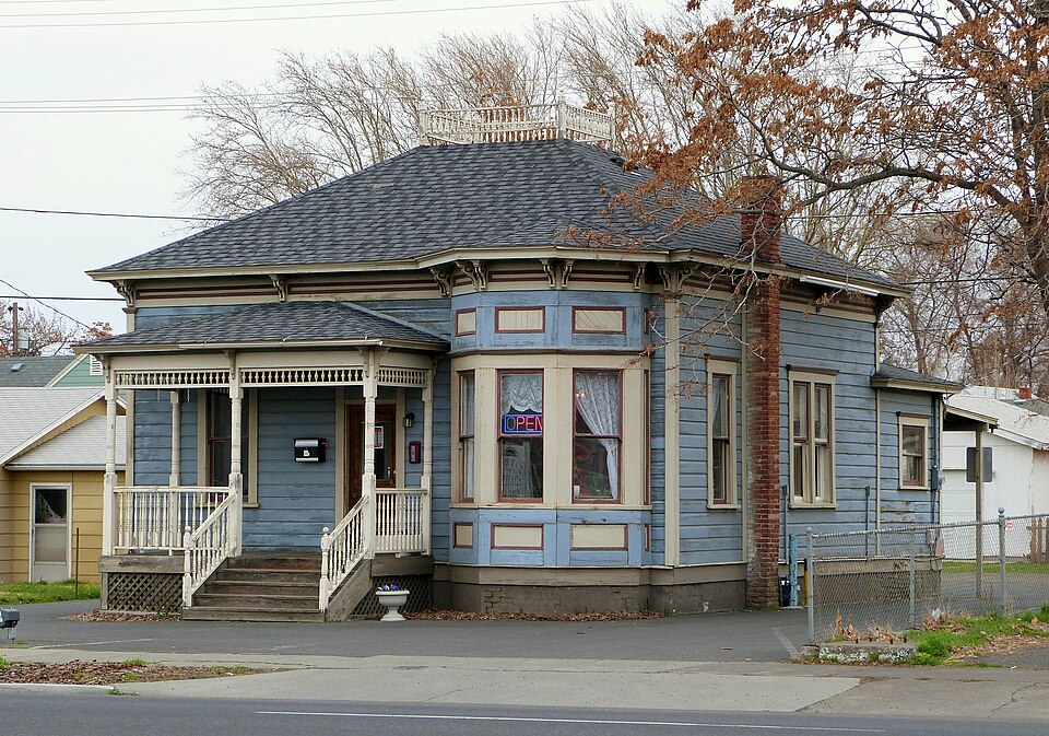
Listed on the National Register of Historic Places in 1994.
One of 43 National Register listings published here for Umatilla County · listed in 1994 · category: Building.
Sources: the case file at the National Archives · the National Register database, National Park Service
Regional context, not property-specific evidence. The federal wildfire occurrence database lists 5 fires within 5 miles of Sarah E. Ireland House between 1992 and 2018, burning about 2,502 acres in total. 1 started naturally. None was recorded as arson. Distance is straight-line from the map coordinates, so a fire counted here may appear on a neighbouring settlement's page as well.
| Reported cause | Fires |
|---|---|
| Missing data/not specified/undetermined | 2 |
| Recreation and ceremony | 1 |
| Equipment and vehicle use | 1 |
| Natural | 1 |
The most recent of them, most recent first, with the day each was reported and the service that recorded it.
| Date | Cause | Size | Reported by | Name on the report |
|---|---|---|---|---|
| 9 September 2006 | Missing data/not specified/undetermined | under an acre | Wallowa-Whitman National Forest | MANN |
| 5 September 2011 | Natural | under an acre | Wallowa-Whitman National Forest | INC 858 |
| 3 August 1992 | Equipment and vehicle use | 80 acres | Pendleton Unit | BOWLUS HILL |
| 17 July 2005 | Recreation and ceremony | 362 acres | Pendleton Unit | NORTH FORK OF WALLA WALL |
| 13 July 2018 | Missing data/not specified/undetermined | 2,060 acres | Umatilla Agency | MILTON-FREEWATER ASSIST |
Regional context, not property-specific evidence. The federal mineral resources record lists 34 workings within 5 miles of Sarah E. Ireland House: 24 past producers, 10 producers. 10 still produce. What was taken out: Sand and Gravel, Construction, Stone, Crushed/Broken, Stone, Geothermal. Distance is straight-line from the map coordinates, so a quarry counted here may appear on a neighbouring settlement's page as well.
| Where | Site | Commodity | Status | Recorded |
|---|---|---|---|---|
| Mf Pit and Plant | Stone | Past Producer | ||
| Unnamed Well | Geothermal | Producer | ||
| Blue Mtn Station | Stone, Crushed/Broken | Producer | ||
| Casper Quarry | Stone, Crushed/Broken | Producer | ||
| Komen Pit | Stone, Crushed/Broken | Producer | ||
| Mf Pit and Plant | Stone, Crushed/Broken | Producer | ||
| Blue Mtn Station | Sand and Gravel, Construction | Past Producer | Sedimentary | |
| Casper Quarry | Sand and Gravel, Construction | Past Producer | Sedimentary | |
| Eastside Pit | Sand and Gravel, Construction | Past Producer | ||
| Eastside Pit | Sand and Gravel, Construction | Past Producer | Sedimentary |
Regional context, not property-specific evidence. The National Weather Service names Milton--Freewater, the town this property stands in, in 10 storm reports between 2004 and 2022: 4 thunderstorm wind, 3 hail, 1 funnel cloud, 1 heavy rain. The reports record 1 death. Each account below is quoted exactly as the forecast office filed it, from the NOAA Storm Events Database, and each date opens the federal record of that event.
| When | Event | Place named | Harm | What the report says |
|---|---|---|---|---|
| February 2020 | Flood | Milton Freewater | 1 killed, $39,700,000 | Umatilla County There was record flooding along the entire reach of the Umatilla River. There was extensive damage to areas along the river, including homes, roads including Interstate 84, railroads as well as other public facilities such as parks and sports complexes. Along the upper reaches of the river, roads were washed out with homes damaged or destroyed. One resident was swept away by flood waters and died. A number of residents had to be evacuated via helicopter or 4 wheeler with 70 homes on the Umatilla Indian Reservation damaged. The Riverview Mobile Home Park at Pendleton was inundated. There was minimal to no damage through Pendleton, due to the levee, but the Bob White Baseball field had extensive damage as water overtopped a low wall. Adjacent to Pendleton, the levee was damaged and overtopped with water flowing through the Keystone RV Manufacturing plant and the Colby Pipe Company. Several bridges and roads downstream from Reith to Echo were damaged or washed out with a number of homes damaged. Downstream from Echo to the confluence of Columbia River, the river rose out of the banks and flooded Interstate 84 between Highway 395 and Highway 208. Several semi-trucks were stranded in the flood waters with extensive damage to the highway. Numerous pastures and buildings along the river through Stanfield were flooded with extensive damage to Oxbow Park in Hermiston and to a sports complex in Umatilla. There was extensive flooding as well as on the Walla Walla River from the headwaters through Milton Freewater and on the upper reaches of Mill Creek. Numerous levees along the Umatilla and Walla Walla Rivers were damaged or overtopped including near Milton Freewater, several locations on the Umatilla Indian Reservation and adjacent to Pendleton. Damage is estimated at 1.3 million dollars to private property on the Umatilla Indian Reservation, with damage for public infrastructure for the entire county at 39.7 million dollars.||Umatilla at Pendleton Flood stage is 12.3 feet. The river rose above flood stage on February 6th 1230 pm, crested at 19.18 feet on February 6th at 10 pm, then fell below flood stage on February 8th at 11am. This was a record peak flow of 19,400 cfs. Highway 11(major access way to Pendleton) was closed due to water flowing over the road. Several bridges and roads downstream from Reith to Echo were damaged or washed out with a number of homes damaged. Umatilla near Gibbon Flood Stage is 7.0 feet. The river rose above flood stage on February 6th, at 2 am, crested at 12.14 feet on February 6th, at 130 pm, then fell below flood stage on February 8th at 645 pm. This was a record peak flow of 13,900 cfs. There was extensive damage along the upstream portions of the river with over 70 homes damaged, roads and railroad tracks washed out, levee damaged or washed out. |
| August 2022 | Thunderstorm Wind | Milton Freewater | - | A NWS Storm Survey conducted the day after the event revealed areas of isolated down trees and tree branches, where one of the downed trees had landed on a home. There was also an area of corn crops that had been blown over in a unidirectional manner. |
| August 2022 | Thunderstorm Wind | Milton Freewater | - | A downburst occurred from a strong thunderstorm that affected several unoccupied, parked mobile homes. One of the mobile homes was lifted 30 feet into a neighboring mobile home, destroying the lifted mobile home. Other mobile homes suffered some roof and other structural damage, as evidenced from broken glass and insulation around the site. |
| September 2013 | Thunderstorm Wind | Milton Freewater | - | Spotter reported 10 inch diameter tree down. |
| September 2013 | Thunderstorm Wind | Milton Freewater | - | Spotter reported many cottonwood trees on the neighbors property damaged with tops broken off from high winds. |
| June 2010 | Heavy Rain | Milton Freewater | - | Late frost and heavy rainfall caused at $3.5 million loss to the cherry crop around Milton-Freewater. |
| April 2006 | Funnel Cloud | Milton Freewater | - | Resident observed funnel cloud form and dissipate over golf course. |
| June 2004 | Hail | Milton Freewater | - | no account filed |
| August 2004 | Hail | Milton Freewater | - | no account filed |
| August 2004 | Hail | Milton Freewater | - | no account filed |
No historic map-sheet match is published for this property yet. That does not mean no map exists. This record needs a coordinate-quality review before it can be joined to a sheet boundary. Browse the county's mapped places while that work is pending.
Other National Register properties close enough to walk or drive between, ordered by distance from this one. Both positions come from the same geocoding pass that matched these properties to their map sheets.
| Photograph | Property | Distance | Listed |
|---|---|---|---|
 | Still-Perkins House | 0.2 miles | 1993 |
 | Central School | 0.2 miles | 2010 |
 | Columbia College | 0.3 miles | 2004 |
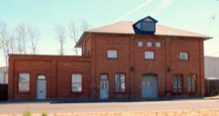 | Walla Walla Valley Traction Company Passenger Station and Powerhouse | 0.7 miles | 1993 |
| Williams Frazier Farmstead | 0.8 miles | 1986 | |
| J.L. Elam Bank | 0.9 miles | 2024 |
| National Archives record | The nomination case file for reference 93001500 in Record Group 79. |
| Umatilla County | All 43 listed properties in this county. |