Listed on the National Register of Historic Places in
1973. A historic map-sheet match is not published yet. The record needs a coordinate-quality review before it can be joined to a sheet boundary.
From the record
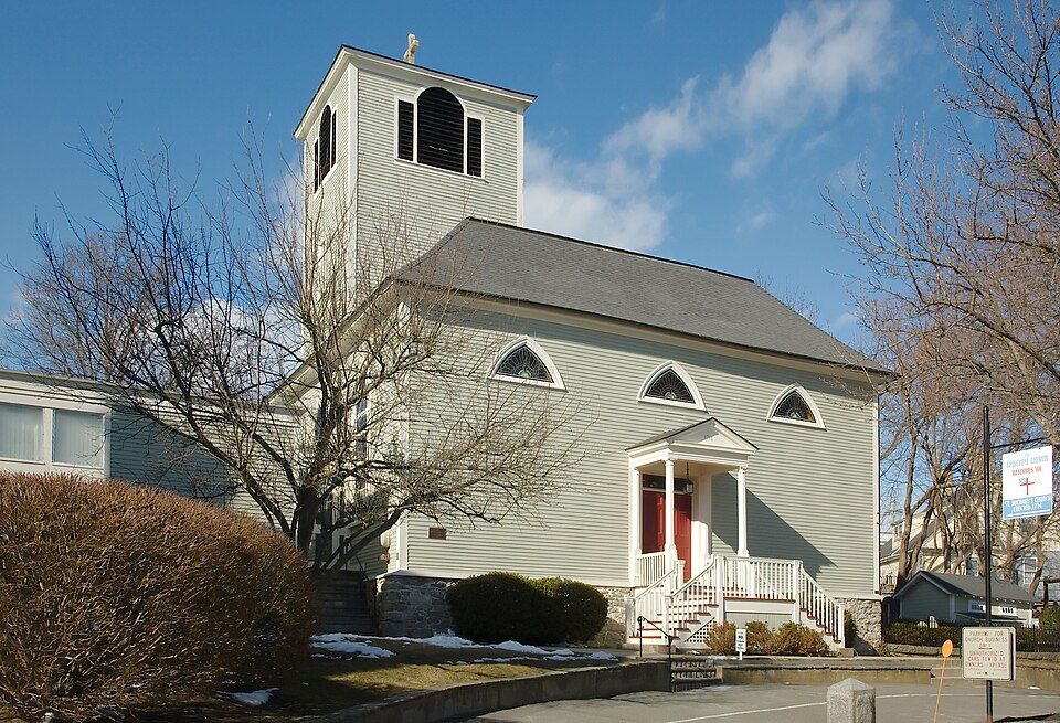
“Michael's Church is an historic Episcopal church in Marblehead, Massachusetts. Built in 1714, it is New England's oldest Episcopal church building on its original site.”
Wikipedia article St. Michael's Church (Marblehead, Massachusetts), CC BY-SA 4.0.
one of 350 National Register listings in Essex County · listed in 1973 · category: Building · one of 2 National Historic Landmarks in Essex County.
National Register reference number.73000305- the number the National Park Service assigned this property when it was listed, and the key its nomination file is catalogued under at the National Archives.
Fires near this property
28 since 2014
Regional context, not property-specific
evidence. The
federal wildfire occurrence database
lists 28 fires within 5 miles of St. Michael's Church between
2014 and 2020, burning about 154 acres in total. None started naturally. None was recorded as arson.
Distance is straight-line from the map coordinates, so a fire counted
here may appear on a neighbouring settlement's page as well.
Reported cause
Fires
Recreation and ceremony
11
Smoking
5
Equipment and vehicle use
5
Debris and open burning
3
Fireworks
1
Missing data/not specified/undetermined
1
Railroad operations and maintenance
1
Misuse of fire by a minor
1
The most recent of
them, most recent first, with the day each was reported and the service
that recorded it.
Regional context, not property-specific
evidence. Museums hold 8,213 specimens
collected within 10 miles of St. Michael's Church between 1800 and
1975: 3,279 Plantae, 2,188 Animalia, 1,139 Fungi, 925 Chromista, 482 Unrecorded, 138 Bacteria, 62 Protozoa. 12 distinct Species records are shown.
Collected by A H HIGGINSON, A. A. Eaton, A. B. Hervey and others. Each is a
physical object with a catalogue
number, and each entry opens the museum's record. This is what was
collected and kept, not a survey of what lives here - nothing can be
concluded from a species being absent.
Regional context, not property-specific
evidence. The federal mineral resources record lists
6 workings within 5 miles of St. Michael's Church: 3 plants, 1 unknown, 1 producer, 1 past producer.
4 still produce. What was taken out: Stone, Crushed/Broken, Zirconium, Mercury, Silver, Gold, REE. Distance is straight-line from the
map coordinates, so a quarry counted here may appear on a neighbouring
settlement's page as well.
Regional context, not property-specific
evidence. The National Weather Service names
Marblehead, the town this property stands in, in 12 storm reports between 1998 and 2016: 6 thunderstorm wind, 4 lightning, 1 heavy rain, 1 flash flood.
No death or injury is recorded in these reports. Each account below is quoted exactly as the forecast office
filed it, from the NOAA Storm Events Database, and each date
opens the federal record of that event.
Numerous streets were closed due to flooding. Approximately 500 houses experienced some sort of flooding, 100 of these houses had to have the electricity cut off to prevent further problems related to basement flooding. Water levels in houses were reported to be between 4 and 9 feet deep. Six houses on Elmwood Road had at least 8 feet of water on the 1st floor. On Paradise Road between the 300 block and 1000 block, 90 percent of the businesses had water damage. Orchard, Bradley, and Elmwood Roads, Humphrey, Burrill, New Ocean, and Columbia Streets, Shepard and Atlantic Avenues, and Sculpin Way were still closed around 2pm because of flooding, several hours after rain had stopped. One elementary school was closed, while other schools in the area delayed opening because of the flooding. In Lynn, Chatham Street was closed due to flooding and approximately 180 homes experienced severe flooding in the basements. Seven city buildings sustained water damage, the worst being Harrington Elementary and Marshall Middle School with water coming in from below and through the roof.
No historic map-sheet match is published
for this property yet. That does not mean no map exists. This record needs
a coordinate-quality review before it can be joined to a sheet boundary.
Browse the county's mapped places while that work is
pending.
From the nomination file
2,657 words on record
When this property was proposed for the
National Register, someone wrote the case for it: what the building is,
and why it matters. That document is a federal record in the public domain.
It is quoted below word for word, never summarised. The text was read off the scanned case file by machine, so the
occasional stray character is the recogniser's and the 1970s
typewriter's.
Description of the property
I Michael's Church, 26 Pleasant Street, is situated on a knoll and, before later construction and landscaping surrounded it, was a prominent landmark when seen from the harbor. The church land extends north from Summer Street to Pleasant Street with a small area on Washington Street to the east. main entrance faces Summer Street and is reached by a semi-circular drive surrounded by lawn and large trees. To the east of the building is a small, early graveyard. The recent parish house is to the west of the church on a lower level and is connected to it by a passageway. Typical of old Marble- head, the nearby houses have all been built in close proximity to the church and each other. Built in 1714-15, the church is of narrow clapboard with a foundation of native stone.
Originally the building was forty-eight feet square; in 1728 it was extended by fifteen feet on the north side. When built the church was of an unusual design, apparently unique among contemporary meeting houses in New England, varying from them in roof design, plan, vaulting, and location of steeple. Concealed under the present massive hip roof, added in 1728, is the structure of the original roof, a parallel series of three elongated hipped roofs running in the east-west direction, joined to one another by means of a single ridge set perpendicularly along the north-south axis.
Heavy beams were hollowed out to form a system of open wooden gutters, set at a steep pitch in the valleys, and designed to provide adequate drainage» The steeple was placed off-center over the central bay on the western side.
St. Michael's Church in Marblehead is believed to be the oldest Episcopal Church still in use in New England."It was conceived as a feturn to the Anglican religion in 1714 by dissenters rebelling against the rule of Puritans and other independent religions. The "Benefactors" included thirty captains of vessels with the main contributor Colonel Nicholson, colonial governor of New York, Maryland and Virginia. An initial four hundred and sixteen pounds was raised to establish the church. Shortly thereafter a group of forty one contributed an additional three hundred and seventy three pounds for the building of a "Handsome Church in the Town of Marblehead". The church was completed in June, 1715 and its first minister, William Shaw, arrived from England a month later.
Difficulties soon developed in this predominately Congregational town, where the Anglican parish was forced to contribute to the support of other churches and "meetings", until a ruling was obtained from Governor Shute making such contributions voluntary. As the parish was poor and had extended itself too far in building the church, it was slow in acquiring the necessary church appointments. A bell was acquired in 1717, the communion service was given in 1724 and the chan- delier in 1732. The ministers put out constant appeals for prayer books. Tradition has it that the bell was later cracked from continuous ringing to celebrate the news of the Declaration of Independence. The bell was recast in 1818 by Paul Revere and is still in use.
The congregation increased for a period, its new affluence allowing, in 1728, the purchase of contiguous land and a fifteen foot addition to the building. After his visit in July 1744, Dr. Alexander Hamilton described the church's appointments in enthusiastic detail.
Quoted from the National Register nomination
for reference 73000305, 12 pages, held by the National Archives in Record
Group 79. See the
catalogue record.
Listed places nearby
6 within 8 miles
Other National Register properties close
enough to walk or drive between, ordered by distance from this one. Both
positions come from the same geocoding pass that matched these properties
to their map sheets.
Listing record. National Park Service National Register of Historic Places, listed-properties dataset, current to 2026-05-22.
Map join. Address geocoded through the United States Census geocoder, then tested against the published boundary of every sheet in the USGS Historical Topographic Map Collection.
How this page is made. Listing fields come from federal records; map-sheet coverage is a labelled coordinate-to-boundary calculation, not a source-field claim.
Wildfire. Short, Karen C. 2022. Spatial wildfire occurrence data for the United States, 1992-2020 [FPA_FOD_20221014]. 6th Edition. Fort Collins, CO: Forest Service Research Data Archive. https://doi.org/10.2737/RDS-2013-0009.6 Collected with United States Government funding and usable without additional permissions or fees.
Specimens. Global Biodiversity Information Facility (GBIF), https://www.gbif.org/. Only records licensed CC0 or CC BY are used. Records licensed CC BY-NC are excluded because this site carries advertising. Images are checked individually and any whose licence is non-commercial, no-derivatives or unreadable is refused.
Mines and quarries. USGS Mineral Resources Data System (MRDS) https://mrdata.usgs.gov/mrds/ A work of the United States government, no copyright under 17 U.S.C. 105.
Storms. NOAA National Centers for Environmental Information, Storm Events Database https://www.ncei.noaa.gov/stormevents/ A work of the United States government, no copyright under 17 U.S.C. 105. Narratives are quoted verbatim from the National Weather Service report and are not edited or summarised.
 Block
Block