Built in 1826. Listed on the National Register of Historic Places in
1973. A historic map-sheet match is not published yet. The record needs a coordinate-quality review before it can be joined to a sheet boundary.
From the record
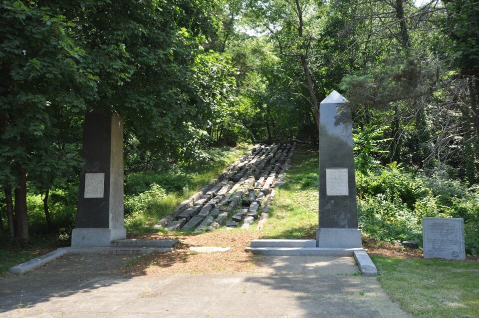
“The Granite Railway was one of the first railroads in the United States, built to carry granite from Quincy, Massachusetts, to a dock on the Neponset River in Milton. From there boats carried the heavy stone to Charlestown for construction of the Bunker Hill Monument.”
Wikipedia article Granite Railway, CC BY-SA 4.0.
one of 249 National Register listings in Norfolk County · listed in 1973 · category: Structure · built in 1826 · one of 2 National Historic Landmarks in Norfolk County.
National Register reference number.73000309- the number the National Park Service assigned this property when it was listed, and the key its nomination file is catalogued under at the National Archives.
Fires near this property
250 since 2015
Regional context, not property-specific
evidence. The
federal wildfire occurrence database
lists 250 fires within 5 miles of Quincy Granite Railway between
2015 and 2020, burning about 145 acres in total. None started naturally. None was recorded as arson.
Distance is straight-line from the map coordinates, so a fire counted
here may appear on a neighbouring settlement's page as well.
Reported cause
Fires
Recreation and ceremony
180
Smoking
40
Missing data/not specified/undetermined
23
Debris and open burning
3
Equipment and vehicle use
2
Fireworks
1
Railroad operations and maintenance
1
The most recent of
them, most recent first, with the day each was reported and the service
that recorded it.
Regional context, not property-specific
evidence. Museums hold 9,694 specimens
collected within 10 miles of Quincy Granite Railway between 1810 and
1975: 4,643 Plantae, 2,765 Animalia, 1,938 Fungi, 144 Chromista, 141 Protozoa, 45 Unrecorded, 18 Bacteria. 12 distinct Species records are shown.
Collected by (MARSDEN, H W), ?, A C Gibson and others. Each is a
physical object with a catalogue
number, and each entry opens the museum's record. This is what was
collected and kept, not a survey of what lives here - nothing can be
concluded from a species being absent.
Regional context, not property-specific
evidence. The federal mineral resources record lists
5 workings within 5 miles of Quincy Granite Railway: 3 producers, 2 past producers.
3 still produce. What was taken out: Sand and Gravel, Construction, Granite, Stone, Crushed/Broken. Distance is straight-line from the
map coordinates, so a quarry counted here may appear on a neighbouring
settlement's page as well.
Regional context, not property-specific
evidence. The National Weather Service names
Quincy, the town this property stands in, in 29 storm reports between 1995 and 2025: 10 thunderstorm wind, 8 flood, 5 flash flood, 3 hail.
No death or injury is recorded in these reports. Each account below is quoted exactly as the forecast office
filed it, from the NOAA Storm Events Database, and each date
opens the federal record of that event.
Several streets in the area of Quincy, Braintree, and Milton were flooded with one to two feet of water. One car was stuck in flood waters at Granite and Chickatawbut Roads in Quincy.
In Quincy, a tree was down on a car at the intersection of Evans Street and West Squantum Street. A person was trapped and extricated, but fortunately was uninjured. Police report relayed by amateur radio.
No historic map-sheet match is published
for this property yet. That does not mean no map exists. This record needs
a coordinate-quality review before it can be joined to a sheet boundary.
Browse the county's mapped places while that work is
pending.
From the nomination file
2,429 words on record
When this property was proposed for the
National Register, someone wrote the case for it: what the building is,
and why it matters. That document is a federal record in the public domain.
It is quoted below word for word, never summarised. The text was read off the scanned case file by machine, so the
occasional stray character is the recogniser's and the 1970s
typewriter's.
Description of the property
The extant portion of the Granite Railway in Quincy is located 120' north of the termination of Bunker Hill Lane. The area is also littered with boulders, the remnants of once productive quarries. A dirt path, commencing at the north end of Bunker Hill Lane, leads to the railway and the defunct Bunker Hill Quarry. "The railway begins at the base of the quarry and runs in a northeast direction for 250'. The line, constructed in 1826, was laid on a road bed 1' - 4' deep to eliminate damage from frost. The bed was filled with stone and the rail structure was constructed in the following manner: 16 Stone sleepers were laid across the track eight feet > apart. Upon these, wooden rails, six inches thick and RECEIVED twelve inches high, were placed.
Upon the top of these Ozails, iron plates, three inches wide and one-fourth of an inch thick, were fastened with spikes; but at all the APR 4 1973 ccrossings of public roads and driftways stone rails were NATIONAL used intead of wood. On top of these were placed iron REGISTER Toplates four inches wide and half an inch thick, being firmly bolted to the stone. the wooden rails began to decay, they were replaced with stone There are no rails left today. The granite sleepers were cut to a size 7' long, 8" - 14" across the top, and 12" - 18" deep. Each sleeper had a round, hand-drilled and centered hole about 1½" in diameter and 12" from each end of the sleeper. The holes were Today, the granite sleepers are the most prominent part of the railway.
Beginning at the base of the quarry, on the south side of the dirt path, is located perhaps the first sleeper and the beginning of the railway.
In a sense, the Battle of Bunker Hill is responsible for the first commercial railway in the United States. In 1823, the Bunker Hill Memorial Association was formed and the patriotic zeal of its organizers brought together engineers, architects and financiers to commemorate the historic battle. Once a suitable design for the monument, an obelisk, was decided upon, its architect and master builder, Solomon Willard, located a quarry of granite in West Quincy to supply the construction material. The next problem was how to transport the granite to the monument site, a distance of twelve miles. Gridley Bryant, a thirty-six year old engineer, proposed a railway from the quarry to the Neponset River, where barges could then transport the granite to the monument site.
The idea was considered quixotic. Never- theless, Thomas Hanasyd Perkins, the merchant prince of Boston, provided the financial backing for Bryant's scheme and the Massachusetts General Court, amid the cries of "what do we know about railroads", approved the petition for incorporation. On October 7, 1826, a horse drawn railway car traversed the three mile distance to the Neponset River. At a time when canals were considered the most efficient mode of transportation, the railway was met with skepticism. Daniel Webster, returning from the funeral of John Adams, inspected Bryant's work and concluded that the future of such a mode of transportation was dubious. However, Webster had not recognized the remarkable engineering genius of Bryant.
In the period of just seven months, from the receipt of the incorporating charter to the opening of the railway, Bryant had perfected machinery fundamental to the early development of the railroad, such as the eight wheeled car, the turn- table, the portable derrick, the switch, and the turnout.
Quoted from the National Register nomination
for reference 73000309, 11 pages, held by the National Archives in Record
Group 79. See the
catalogue record.
Listed places nearby
6 within 8 miles
Other National Register properties close
enough to walk or drive between, ordered by distance from this one. Both
positions come from the same geocoding pass that matched these properties
to their map sheets.
Listing record. National Park Service National Register of Historic Places, listed-properties dataset, current to 2026-05-22.
Map join. Address geocoded through the United States Census geocoder, then tested against the published boundary of every sheet in the USGS Historical Topographic Map Collection.
How this page is made. Listing fields come from federal records; map-sheet coverage is a labelled coordinate-to-boundary calculation, not a source-field claim.
Wildfire. Short, Karen C. 2022. Spatial wildfire occurrence data for the United States, 1992-2020 [FPA_FOD_20221014]. 6th Edition. Fort Collins, CO: Forest Service Research Data Archive. https://doi.org/10.2737/RDS-2013-0009.6 Collected with United States Government funding and usable without additional permissions or fees.
Specimens. Global Biodiversity Information Facility (GBIF), https://www.gbif.org/. Only records licensed CC0 or CC BY are used. Records licensed CC BY-NC are excluded because this site carries advertising. Images are checked individually and any whose licence is non-commercial, no-derivatives or unreadable is refused.
Mines and quarries. USGS Mineral Resources Data System (MRDS) https://mrdata.usgs.gov/mrds/ A work of the United States government, no copyright under 17 U.S.C. 105.
Storms. NOAA National Centers for Environmental Information, Storm Events Database https://www.ncei.noaa.gov/stormevents/ A work of the United States government, no copyright under 17 U.S.C. 105. Narratives are quoted verbatim from the National Weather Service report and are not edited or summarised.
 Block
Block