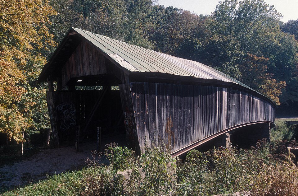
Built in 1874. Listed on the National Register of Historic Places in
1973. A historic map-sheet match is not published yet. The record needs a coordinate-quality review before it can be joined to a sheet boundary.
From the record
“The Ponn Humpback Covered Bridge was a historic covered bridge in the southeastern part of the U.S. state of Ohio. Located near the village of Wilkesville in Vinton County, it bore a name derived from its unusual shape: the bridge was arched in the middle, rather than being flat like a typical covered bridge.”
Wikipedia article Ponn Humpback Covered Bridge, CC BY-SA 4.0.
one of 6 National Register listings in Vinton County · listed in 1973 · category: Structure · built in 1874.
National Register reference number.73001545- the number the National Park Service assigned this property when it was listed, and the key its nomination file is catalogued under at the National Archives.
Fires near this property
22 since 2007
Regional context, not property-specific
evidence. The
federal wildfire occurrence database
lists 22 fires within 5 miles of Ponn Humpback Covered Bridge between
2007 and 2019, burning about 65 acres in total. None started naturally. None was recorded as arson.
Distance is straight-line from the map coordinates, so a fire counted
here may appear on a neighbouring settlement's page as well.
Reported cause
Fires
Debris and open burning
12
Missing data/not specified/undetermined
8
Recreation and ceremony
1
Equipment and vehicle use
1
The most recent of
them, most recent first, with the day each was reported and the service
that recorded it.
Regional context, not property-specific
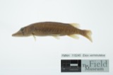
evidence. Museums hold 45 specimens
collected within 10 miles of Ponn Humpback Covered Bridge between 1929 and
1972: 24 Animalia, 19 Plantae, 2 Fungi. 12 distinct Species records are shown.
Collected by C. F. Reed, C. H. Jones, Collector(s): Woodrow W. Goodpaster; Preparator(s): Woodrow W. Goodpaster and others. Each is a
physical object with a catalogue
number, and each entry opens the museum's record. This is what was
collected and kept, not a survey of what lives here - nothing can be
concluded from a species being absent.
Regional context, not property-specific
evidence. The National Weather Service names
Wilkesville, the town this property stands in, in 18 storm reports between 1996 and 2025: 11 thunderstorm wind, 3 hail, 2 flood, 1 flash flood.
No death or injury is recorded in these reports. Each account below is quoted exactly as the forecast office
filed it, from the NOAA Storm Events Database, and each date
opens the federal record of that event.
A brief tornado touchdown occurred along Ohio 124 1.5 miles WNW of Wilkesville. A new double-wide mobile home was shifted off the block foundation and turned in a westerly direction. Another nearby mobile home was blown a few feet off of its foundation in a southerly direction. Clear rotation was also evident in the direction several uprooted trees were laying and in debris scattered across the property.
Along Covered Bridge Road, several mobile homes were shifted off of their foundations and were damaged. Numerous trees were also downed along the road.
No historic map-sheet match is published
for this property yet. That does not mean no map exists. This record needs
a coordinate-quality review before it can be joined to a sheet boundary.
Browse the county's mapped places while that work is
pending.
From the nomination file
1,030 words on record
When this property was proposed for the
National Register, someone wrote the case for it: what the building is,
and why it matters. That document is a federal record in the public domain.
It is quoted below word for word, never summarised. The text was read off the scanned case file by machine, so the
occasional stray character is the recogniser's and the 1970s
typewriter's.
Description of the property
The Ponn "Humpback" Covered Bridge is located in Wilkesville of the information about it originates with the office of James E. Lee, Vinton County Engineer. The bridge was built by Martin E. McGrath and Lyman Wells, local queen post construction. The slight arch, or hump, of the bridge was apparently for structural, rather than navigational reasons; that is, to allow for a relatively long, uninterrupted span over a boats passing below. the Champion Bridge Company of Wilmington, Ohio reinforced the under- These run the entire underside of the bridge on both sides. channels are visible just below the exterior siding, but hardly it did originally, with allowance for wear and tear.
It is functional CONDITION NATIONAL Excellent REGISTER Ruins relatively deep gorge, rather than to allow additional headroom for Township,Geer Road over Raccoon Creek in Vinton County.Most architecture is of wooden truss construction with Burr arches, NOV 20 1972 contractors. It was completed and accepted by the county commissioners are two sandstone piers about twenty-four feet from each end of entire operation cost $1194 in labor and materials. in December, 1874. It is 165 feet long and 14 feet wide. There the bridge, which serve as intermediate supports. The interior There and cars passing along Geer Road may drive through it. RECEIVED change the appearance of the bridge.Essentially it must look as Fair The steel - Pre-Columbian!
- 20th Century SPECIFIC DATE(S) (If Applicable and Known) AREAS OF
Statement of significance
Ponn Bridge, with its "humpbacked" construction, is one of the longest and most unusual covered bridges in Ohio. It is one of five covered bridges in Vinton County. One other of them, the Eakin Mill or McLaughlin Bridge, is of similar construction, though will probably not be repaired, making the Ponn Bridge even more another contribution to its worth. 1874 Engineering Commerce Conservation Communications Transportation Aboriginal Architecture Landscape Science Literature REGISTER NATIONAL Prehistoric SIGNIFICANCE itarian Agriculture Invention Social/Human- Music Sculpture Political Religion/Phi NOV 20 1972 Theater PERIOD (Check One or More as Appropriate) shorter in length. However, it has been severely damaged and precious.
Its beautiful setting, over Raccoon Creek, is losophy Art RECEIVED
Quoted from the National Register nomination
for reference 73001545, 8 pages, held by the National Archives in Record
Group 79. See the
catalogue record.
Listing record. National Park Service National Register of Historic Places, listed-properties dataset, current to 2026-05-22.
Map join. Address geocoded through the United States Census geocoder, then tested against the published boundary of every sheet in the USGS Historical Topographic Map Collection.
How this page is made. Listing fields come from federal records; map-sheet coverage is a labelled coordinate-to-boundary calculation, not a source-field claim.
Wildfire. Short, Karen C. 2022. Spatial wildfire occurrence data for the United States, 1992-2020 [FPA_FOD_20221014]. 6th Edition. Fort Collins, CO: Forest Service Research Data Archive. https://doi.org/10.2737/RDS-2013-0009.6 Collected with United States Government funding and usable without additional permissions or fees.
Specimens. Global Biodiversity Information Facility (GBIF), https://www.gbif.org/. Only records licensed CC0 or CC BY are used. Records licensed CC BY-NC are excluded because this site carries advertising. Images are checked individually and any whose licence is non-commercial, no-derivatives or unreadable is refused.
Storms. NOAA National Centers for Environmental Information, Storm Events Database https://www.ncei.noaa.gov/stormevents/ A work of the United States government, no copyright under 17 U.S.C. 105. Narratives are quoted verbatim from the National Weather Service report and are not edited or summarised.
 Block
Block