Listed on the National Register of Historic Places in
1974. A historic map-sheet match is not published yet. The record needs a coordinate-quality review before it can be joined to a sheet boundary.
From the record
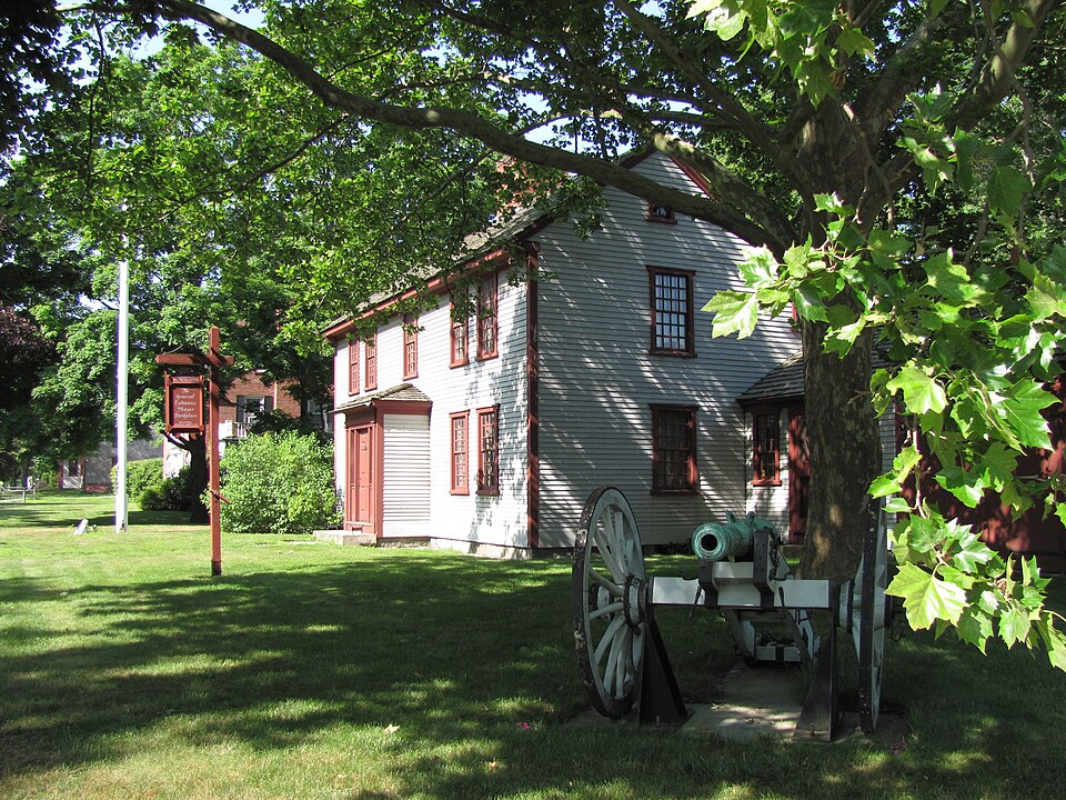
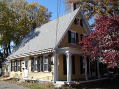
“Sylvanus Thayer House, also known as the Sylvanus Thayer Birthplace, is an historic house at 786 Washington Street in Braintree, Massachusetts. It is operated by the Braintree Historical Society as the Thayer House Museum, which is open year-round.”
Wikipedia article Gen. Sylvanus Thayer House, CC BY-SA 4.0.
one of 249 National Register listings in Norfolk County · listed in 1974 · category: Building · one of 2 National Historic Landmarks in Norfolk County.
National Register reference number.74000372- the number the National Park Service assigned this property when it was listed, and the key its nomination file is catalogued under at the National Archives.
Fires near this property
317 since 2015
Regional context, not property-specific
evidence. The
federal wildfire occurrence database
lists 317 fires within 5 miles of Thayer, Gen. Sylvanus, House between
2015 and 2020, burning about 193 acres in total. None started naturally. None was recorded as arson.
Distance is straight-line from the map coordinates, so a fire counted
here may appear on a neighbouring settlement's page as well.
Reported cause
Fires
Recreation and ceremony
218
Smoking
55
Missing data/not specified/undetermined
30
Debris and open burning
9
Equipment and vehicle use
3
Fireworks
1
Railroad operations and maintenance
1
The most recent of
them, most recent first, with the day each was reported and the service
that recorded it.
Regional context, not property-specific
evidence. Museums hold 7,308 specimens
collected within 10 miles of Thayer, Gen. Sylvanus, House between 1815 and
1975: 3,630 Plantae, 2,079 Animalia, 1,441 Fungi, 75 Protozoa, 45 Chromista, 28 Unrecorded, 10 Bacteria. 12 distinct Species records are shown.
Collected by (MARSDEN, H W), A C Gibson, A Phelps Wyman and others. Each is a
physical object with a catalogue
number, and each entry opens the museum's record. This is what was
collected and kept, not a survey of what lives here - nothing can be
concluded from a species being absent.
Regional context, not property-specific
evidence. The federal mineral resources record lists
18 workings within 5 miles of Thayer, Gen. Sylvanus, House: 10 producers, 8 past producers.
10 still produce. What was taken out: Sand and Gravel, Construction, Granite, Stone, Crushed/Broken. Distance is straight-line from the
map coordinates, so a quarry counted here may appear on a neighbouring
settlement's page as well.
Regional context, not property-specific
evidence. The National Weather Service names
Braintree, the town this property stands in, in 21 storm reports between 1998 and 2025: 8 thunderstorm wind, 5 flood, 3 lightning, 3 hail.
No death or injury is recorded in these reports. Each account below is quoted exactly as the forecast office
filed it, from the NOAA Storm Events Database, and each date
opens the federal record of that event.
A house on Central Avenue caught fire after being struck by lightning. The fire spread quickly turning into a three alarm fire and causing substantial damage to the house. No one was home at the time of the fire.
A trained spotter reported a wind gust to 62 mph. Numerous trees and wires across Braintree and Holbrook were downed by thunderstorm winds. One of these trees landed on a car on Roseway Street in Holbrook.
Heavy rain resulted in street flooding in several communities across Norfolk County. In Walpole, 50 to 75 feet of Pleasant Street was closed because of water four feet deep in the street. In Norwood, a vehicle was stuck in flood waters with the road impassable. And in Braintree, Union Street was flooded from poor drainage overflow where it crosses under the MBTA railroad bridge.
In Braintree at 605 PM EDT, a resident reported a 64 mph wind gust on their home anemometer. Damage in the immediate area was mostly downed tree limbs.
Route 37 was flooded near 275 Hancock Street. Traffic was diverted down Washington Street to Jefferson Street. Common Street from Granite to Washington was closed due to flooding.
Three to five inches of rain fell across the south Boston metro area. Grossman Drive and the underpass for the MBTA train tracks were flooded in Braintree. Also, Forbes Road near the bus terminal was flooded. In Holbrook, several roads flooded including South Franklin Street, Clara and Loud Roads, and Abington Avenue between Weymouth Street and White Road.
No historic map-sheet match is published
for this property yet. That does not mean no map exists. This record needs
a coordinate-quality review before it can be joined to a sheet boundary.
Browse the county's mapped places while that work is
pending.
From the nomination file
1,987 words on record
When this property was proposed for the
National Register, someone wrote the case for it: what the building is,
and why it matters. That document is a federal record in the public domain.
It is quoted below word for word, never summarised. The text was read off the scanned case file by machine, so the
occasional stray character is the recogniser's and the 1970s
typewriter's.
Description of the property
XX Moved - Unexposed (Check One) - Original Site The Gen.Sylvanus Thayer Birthplace was originally located at 1505 Washington Street and was moved to its present location at 786 Washington Street in 1958. The original 1720 structure was a 2-story 8-room center chimney ridge roof house, 5 bays wide and 1 deep. C.1760 a rear lean-to was added and the central chimney was altered to make the large fireplace in the kitchen. Double hung windows replaced the original front leaded windows and clapboards were added over the exposed siding boards of the exterior. C. 1800 a closed hip-roof entrance porch was added to the facade, the door flanked by side lights and Doric pilasters. Between 1800 and 1820 the interior beams and corner posts were boxed in and the wallpapers changed.
C.1846 a 1½ story salt box shed, 5 bays by 3 bays, was added to the southern gable end of the structure. This extension was slightly enlarged for caretaker's quarters c.1960. The house is covered with unpainted clapboard and red trim. The interior retains its original sheathing, panelling and fireplaces. Origi- nal wallpaper has been found and duplicated. In the Keeping Room is the most unusual architectural feature of the house- a sunken Buttery with brick floor, brick cooling tank, and shelves lining the four sides. The house sits on a broad residential street and is well landscaped with trees and shrubs. A split rail fence surrounds the back yard where a period herbal. garden has been planted. RECÊiVED JUL 2 9 1974 NATIONAL REGISTER <6 :00 M RUCTIONS -
Quoted from the National Register nomination
for reference 74000372, 11 pages, held by the National Archives in Record
Group 79. See the
catalogue record.
Listed places nearby
6 within 8 miles
Other National Register properties close
enough to walk or drive between, ordered by distance from this one. Both
positions come from the same geocoding pass that matched these properties
to their map sheets.
Listing record. National Park Service National Register of Historic Places, listed-properties dataset, current to 2026-05-22.
Map join. Address geocoded through the United States Census geocoder, then tested against the published boundary of every sheet in the USGS Historical Topographic Map Collection.
How this page is made. Listing fields come from federal records; map-sheet coverage is a labelled coordinate-to-boundary calculation, not a source-field claim.
Wildfire. Short, Karen C. 2022. Spatial wildfire occurrence data for the United States, 1992-2020 [FPA_FOD_20221014]. 6th Edition. Fort Collins, CO: Forest Service Research Data Archive. https://doi.org/10.2737/RDS-2013-0009.6 Collected with United States Government funding and usable without additional permissions or fees.
Specimens. Global Biodiversity Information Facility (GBIF), https://www.gbif.org/. Only records licensed CC0 or CC BY are used. Records licensed CC BY-NC are excluded because this site carries advertising. Images are checked individually and any whose licence is non-commercial, no-derivatives or unreadable is refused.
Mines and quarries. USGS Mineral Resources Data System (MRDS) https://mrdata.usgs.gov/mrds/ A work of the United States government, no copyright under 17 U.S.C. 105.
Storms. NOAA National Centers for Environmental Information, Storm Events Database https://www.ncei.noaa.gov/stormevents/ A work of the United States government, no copyright under 17 U.S.C. 105. Narratives are quoted verbatim from the National Weather Service report and are not edited or summarised.
 Block
Block