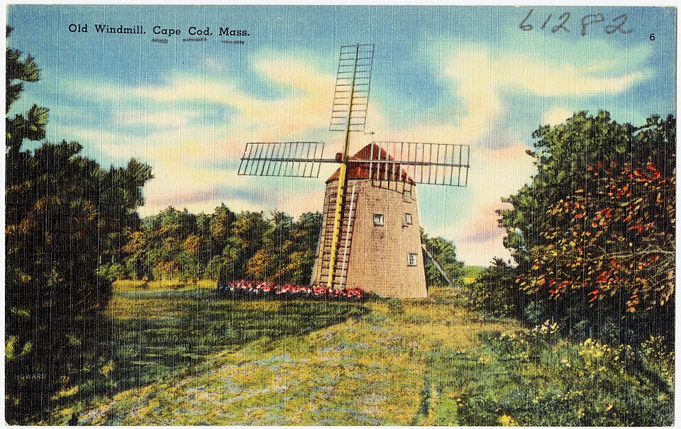
Photograph by Pub. by H. L. Moore Co., West Yarmouth, Mass. Tichnor Bros. Inc., Boston, Mass, Public domain. Via
Wikimedia Commons.
Old Higgins Farm Windmill
Built in 1750. Listed on the National Register of Historic Places in
1975. A historic map-sheet match is not published yet. The record needs a coordinate-quality review before it can be joined to a sheet boundary.
From the record
“Old Higgins Farm Windmill is a historic Smock windmill off of Old King's Highway at Drummer Boy Park in Brewster on Cape Cod in Massachusetts.”
Wikipedia article Old Higgins Farm Windmill, CC BY-SA 4.0.
one of 145 National Register listings in Barnstable County · listed in 1975 · category: Structure · built in 1750.
National Register reference number.75000240- the number the National Park Service assigned this property when it was listed, and the key its nomination file is catalogued under at the National Archives.
Regional context, not property-specific
evidence. The
federal wildfire occurrence database
lists 45 fires within 5 miles of Old Higgins Farm Windmill between
2015 and 2020, burning about 15 acres in total. 3 started naturally. 4 were recorded as arson.
Distance is straight-line from the map coordinates, so a fire counted
here may appear on a neighbouring settlement's page as well.
Reported cause
Fires
Missing data/not specified/undetermined
19
Debris and open burning
12
Arson/incendiarism
4
Recreation and ceremony
4
Natural
3
Equipment and vehicle use
2
Smoking
1
The most recent of
them, most recent first, with the day each was reported and the service
that recorded it.
Regional context, not property-specific
evidence. Museums hold 4,734 specimens
collected within 10 miles of Old Higgins Farm Windmill between 1819 and
1975: 2,878 Animalia, 1,382 Plantae, 251 Fungi, 135 Chromista, 60 Bacteria, 27 Unrecorded, 1 Protozoa. 12 distinct Species records are shown.
Collected by A. B. Seymour, A. R. Hodgdon, A. R. Hodgdon and others. Each is a
physical object with a catalogue
number, and each entry opens the museum's record. This is what was
collected and kept, not a survey of what lives here - nothing can be
concluded from a species being absent.
Regional context, not property-specific
evidence. The National Weather Service names
Brewster, the town this property stands in, in 10 storm reports between 2006 and 2019: 3 thunderstorm wind, 3 flood, 2 lightning, 1 hail.
No death or injury is recorded in these reports. Each account below is quoted exactly as the forecast office
filed it, from the NOAA Storm Events Database, and each date
opens the federal record of that event.
In Brewster, a large tree was down on Stony Brook Road. A tree and power lines were down on Run Hill Road. Numerous other trees were down throughout the town.
At 1139 PM EST, a basement was flooded on Robbins Hill Road in Brewster. At 1215 AM EST, the Ocean Edge Mansion on Main Street had flooding in the parking lot and the west wing of the building. At 1220 AM EST, a basement was reported flooded on Endicott Lane. At 1 AM EST, a basement was flooded on Lunds Farm Way.
No historic map-sheet match is published
for this property yet. That does not mean no map exists. This record needs
a coordinate-quality review before it can be joined to a sheet boundary.
Browse the county's mapped places while that work is
pending.
From the nomination file
3,268 words on record
When this property was proposed for the
National Register, someone wrote the case for it: what the building is,
and why it matters. That document is a federal record in the public domain.
It is quoted below word for word, never summarised. The text was read off the scanned case file by machine, so the
occasional stray character is the recogniser's and the 1970s
typewriter's.
Description of the property
Ihe Old Higgins Farm Windmill is a 30 Ieet high, shingled structure with a fixed octagonal base 20 feet across, and a revolving shingled cap constructed of framing members curved like the hull of a ship. The windshaft, 20 feet long and 16 inches in diameter, is original. A 48 feet tail pole, used to move the cap around, travels in a circle 110 feet in diameter, but due to its rotted condition it will have to be replaced. The sails have been lost and will have to be reconstructed, but 85% of the rest of the structure is original. The windmill has three levels and contains remarkably engineered wooden moving parts. The moveable cap, whose shaft is turned by windpower, contains a large wooden gear called the bread wheel, which turns the upright shaft in the middle of the tower.
This shaft turns the upper and lower grindstones in the middle level of the windmill. A hopper and trough above the grindstones are filled with corn, which feeds out to be ground by the two grindstones. The ground meal is forced down a long shute to the meal trough on the first level. The first level contains a sturdy wooden frame to support the weight of the stones above, as well as a corn cob cracker which grinds cobs into animal feed. The wooden moving parts of the windmill are still extant, and with the planned restoration work the mill will be able to function again very soon. As well as containing remarkable moving parts, the windmill has some unusual carvns an decrations reminiscent i scrimshaw.
These decorations, as well as the boat-like construction methods (curved cap, mast-like windshaft, pegged floor and all wooden materials), gave rise to the local belief that the mill was constructed by ship builders.
/ARCHITECT STATEMENT OF SIGNIFICANCE The Old Higgins Farm Windmill is significant as one of the few remaining windmills of the type once so numerous on Cape Cod, and as the only extant one in Brewster. The design, common in 17th century England, has a fixed base and moveable cap. Because the base is not permanently attached to a foundation, but rests on top of the ground, it, and others of its type, were often moved around. The mill was used to grind corn, the main export crop of Cape Cod in the 19th century, and after the Civil War, when the demand for corn diminished, this mill, and others like it on the Cape, were used with less frequency. The mill is in remarkable condition, with all of its moving parts extant except for the arms and sails.
The interior 'scrimshawe' carvings also add to the windmill's significance. The windmill is now being restored to its original working condition. The windmill has been in the same general location since the late eighteenth . century. In 1795 there were three mills in the area, one of which stood on land belonging to the Crosby family. By 1845, Assessor records show that the Crosby's windmill was the only one in Brewster. At that time, of it was owned jointly by "Higgins and Crosby", I by Nathan Crosby and 1 by Isaac Hopkins. Interest in the mill passed through many hands, but the property never passed entirely out of Crosby ownership. The windmill was probably moved several times during the nineteenth century, but never far from its original location.
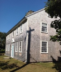
Around 1890 it was moved to the nearby estate of Roland Crosby Nickerson, where it served for many years as a club house at the ninth hole of his private golf course.
Quoted from the National Register nomination
for reference 75000240, 18 pages, held by the National Archives in Record
Group 79. See the
catalogue record.
Listed places nearby
6 within 8 miles
Other National Register properties close
enough to walk or drive between, ordered by distance from this one. Both
positions come from the same geocoding pass that matched these properties
to their map sheets.
Listing record. National Park Service National Register of Historic Places, listed-properties dataset, current to 2026-05-22.
Map join. Address geocoded through the United States Census geocoder, then tested against the published boundary of every sheet in the USGS Historical Topographic Map Collection.
How this page is made. Listing fields come from federal records; map-sheet coverage is a labelled coordinate-to-boundary calculation, not a source-field claim.
Wildfire. Short, Karen C. 2022. Spatial wildfire occurrence data for the United States, 1992-2020 [FPA_FOD_20221014]. 6th Edition. Fort Collins, CO: Forest Service Research Data Archive. https://doi.org/10.2737/RDS-2013-0009.6 Collected with United States Government funding and usable without additional permissions or fees.
Specimens. Global Biodiversity Information Facility (GBIF), https://www.gbif.org/. Only records licensed CC0 or CC BY are used. Records licensed CC BY-NC are excluded because this site carries advertising. Images are checked individually and any whose licence is non-commercial, no-derivatives or unreadable is refused.
Storms. NOAA National Centers for Environmental Information, Storm Events Database https://www.ncei.noaa.gov/stormevents/ A work of the United States government, no copyright under 17 U.S.C. 105. Narratives are quoted verbatim from the National Weather Service report and are not edited or summarised.
 Block
Block