Listed on the National Register of Historic Places in
1976. A historic map-sheet match is not published yet. The record needs a coordinate-quality review before it can be joined to a sheet boundary.
From the record
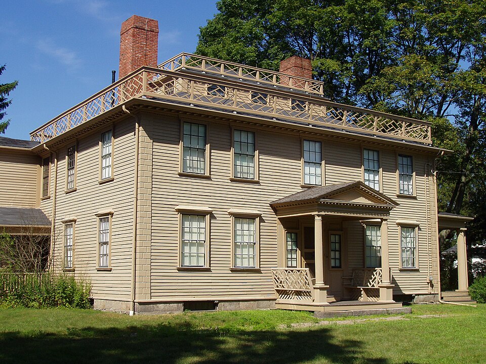
“The Josiah Quincy House, located at 20 Muirhead Street in the Wollaston neighborhood of Quincy, Massachusetts, was the country home of Revolutionary War soldier Colonel Josiah Quincy I, the first in a line of six men named Josiah Quincy that included three Boston mayors and a president of Harvard University.”
Wikipedia article Josiah Quincy House, CC BY-SA 4.0.
one of 249 National Register listings in Norfolk County · listed in 1976 · category: Building · one of 2 National Historic Landmarks in Norfolk County.
National Register reference number.76000285- the number the National Park Service assigned this property when it was listed, and the key its nomination file is catalogued under at the National Archives.
Fires near this property
221 since 2015
Regional context, not property-specific
evidence. The
federal wildfire occurrence database
lists 221 fires within 5 miles of Quincy, Josiah, House between
2015 and 2020, burning about 102 acres in total. None started naturally. None was recorded as arson.
Distance is straight-line from the map coordinates, so a fire counted
here may appear on a neighbouring settlement's page as well.
Reported cause
Fires
Recreation and ceremony
145
Smoking
34
Missing data/not specified/undetermined
20
Debris and open burning
18
Fireworks
2
Misuse of fire by a minor
1
Equipment and vehicle use
1
The most recent of
them, most recent first, with the day each was reported and the service
that recorded it.
Regional context, not property-specific
evidence. Museums hold 11,821 specimens
collected within 10 miles of Quincy, Josiah, House between 1810 and
1975: 5,710 Plantae, 2,735 Fungi, 2,709 Animalia, 400 Chromista, 182 Protozoa, 55 Unrecorded, 30 Bacteria. 12 distinct Species records are shown.
Collected by (MARSDEN, H W), ?, A C Gibson and others. Each is a
physical object with a catalogue
number, and each entry opens the museum's record. This is what was
collected and kept, not a survey of what lives here - nothing can be
concluded from a species being absent.
Regional context, not property-specific
evidence. The federal mineral resources record lists
3 workings within 5 miles of Quincy, Josiah, House: 2 producers, 1 past producer.
2 still produce. What was taken out: Granite, Stone, Crushed/Broken, Sand and Gravel, Construction. Distance is straight-line from the
map coordinates, so a quarry counted here may appear on a neighbouring
settlement's page as well.
Regional context, not property-specific
evidence. The National Weather Service names
Quincy, the town this property stands in, in 29 storm reports between 1995 and 2025: 10 thunderstorm wind, 8 flood, 5 flash flood, 3 hail.
No death or injury is recorded in these reports. Each account below is quoted exactly as the forecast office
filed it, from the NOAA Storm Events Database, and each date
opens the federal record of that event.
Several streets in the area of Quincy, Braintree, and Milton were flooded with one to two feet of water. One car was stuck in flood waters at Granite and Chickatawbut Roads in Quincy.
In Quincy, a tree was down on a car at the intersection of Evans Street and West Squantum Street. A person was trapped and extricated, but fortunately was uninjured. Police report relayed by amateur radio.
No historic map-sheet match is published
for this property yet. That does not mean no map exists. This record needs
a coordinate-quality review before it can be joined to a sheet boundary.
Browse the county's mapped places while that work is
pending.
From the nomination file
3,480 words on record
When this property was proposed for the
National Register, someone wrote the case for it: what the building is,
and why it matters. That document is a federal record in the public domain.
It is quoted below word for word, never summarised. The text was read off the scanned case file by machine, so the
occasional stray character is the recogniser's and the 1970s
typewriter's.
Description of the property
The Josiah Quincy House is situated in the residential Wollaston section of Quincy. Until the end of the nineteenth century the Quincy House was surrounded by an extensive estate with an uninterrupted view to the water's edge. Its site is now reduced to a three-quarter acre lot, and is surrounded by late nineteenth and twentieth century deve lopment. The 1770 house, facing southwest on Muirhead Streef, is a two-story structure surmounted by a three-bay monitor containing four small rooms. A two-story ell for servants ex- tends from the northwest end. A number of outbuildings, including a glass works, a salt works, a windmill and two barns were once on the property; none of them is extant. A garage now stands on or near the site of a former barn.
The house, of frame con- struction with yellow clapboards, has rusticated quoins painted white on both the main structure and the monitor. Local granite was used for its foundation. The house plan, elevation, and construction are typical New England Georgian design of the third quarter of the eighteenth century. In plan, four rooms are symmetrically disposed on each of two similar floors. A nine foot wide central hall contains a staircase with elaborately carved balusters and newel post. The staircase is approached from the rear of the hall, an unusual feature of the house. On each side of the hall pairs of rooms share interior chimneys with back-to-back fireplaces. Each is flanked by doors to allow maximum circulation.
The symmetrical elevation of the Quincy House is composed of five bays, with 6/6 sash windows. A central entrance flanked by half length sidelights of 4/4 sash is monumen- talized by a pedimented portico with dentilled cornice, supported by two fluted Doric columns.
/ARCHITECT Deacon Edward Pierce The Josiah Quincy House is distinguished for its architectural merit in addition to its historic interest as the residence of succeeding generations of the Quincy family until 1893. Since its acquisition in 1937 by SPNEA, it has functioned as a house museum. The present structure was erected in 1770 on land which was originally purchased by Edmund Quincy from the Indian Sachem of Moswechusett in 1636. It replaced the previous house, built in 1750 for Col. Josiah Quincy, which was subsequently destroyed by fire in 1769. Col. Josiah Quincy is generally attributed with the design of the new house. Records indicate that the construction was undertaken by a Dorchester carpenter, Deacon Edward Pierce (1735-1818). The earliest of five extant letters from Col.
Josiah Quincy to Edward Pierce, dated December 19, 1769, enlists the help of the Dorchester carpenter. "I beg this Favour you woud dine with me Tomorrow, or on Thursday, and assist me in projecting a Plan of such a House as I want, making a Schedule of Materials to be collected for the Purpose, and an Estimate of the Cost." (Copy - SPNEA: Permanent File) Architecturally, the Quincy House is a fine example of New England Georgian design in which an advancing classicism characterized by eighteenth century Palladian and chin- oiserie influence is joined together with an indigenous carpentry tradition. TO3 S. 5.) AEIOTC: Eaucco The interior of the Josiah Quincy House is furnished to a large extent with items that have Quincy family associations.
Some of these, like the English settee and the japanned high chest, were brought to the house by Col. Josiah Quincy; these items are also men- tioned in his inventory of 1784. Others were brought to the house or accumulated by family members through the eighteenth and nineteenth centuries.
Quoted from the National Register nomination
for reference 76000285, 14 pages, held by the National Archives in Record
Group 79. See the
catalogue record.
Listed places nearby
6 within 8 miles
Other National Register properties close
enough to walk or drive between, ordered by distance from this one. Both
positions come from the same geocoding pass that matched these properties
to their map sheets.
Listing record. National Park Service National Register of Historic Places, listed-properties dataset, current to 2026-05-22.
Map join. Address geocoded through the United States Census geocoder, then tested against the published boundary of every sheet in the USGS Historical Topographic Map Collection.
How this page is made. Listing fields come from federal records; map-sheet coverage is a labelled coordinate-to-boundary calculation, not a source-field claim.
Wildfire. Short, Karen C. 2022. Spatial wildfire occurrence data for the United States, 1992-2020 [FPA_FOD_20221014]. 6th Edition. Fort Collins, CO: Forest Service Research Data Archive. https://doi.org/10.2737/RDS-2013-0009.6 Collected with United States Government funding and usable without additional permissions or fees.
Specimens. Global Biodiversity Information Facility (GBIF), https://www.gbif.org/. Only records licensed CC0 or CC BY are used. Records licensed CC BY-NC are excluded because this site carries advertising. Images are checked individually and any whose licence is non-commercial, no-derivatives or unreadable is refused.
Mines and quarries. USGS Mineral Resources Data System (MRDS) https://mrdata.usgs.gov/mrds/ A work of the United States government, no copyright under 17 U.S.C. 105.
Storms. NOAA National Centers for Environmental Information, Storm Events Database https://www.ncei.noaa.gov/stormevents/ A work of the United States government, no copyright under 17 U.S.C. 105. Narratives are quoted verbatim from the National Weather Service report and are not edited or summarised.
 Block
Block