Built in 1887 in the Stick style. Listed on the National Register of Historic Places in
1978. A historic map-sheet match is not published yet. The record needs a coordinate-quality review before it can be joined to a sheet boundary.
From the record
“Chatham station is a former railroad station located on Depot Road in Chatham, Massachusetts. In use from 1887 to 1937, it has housed the Chatham Railroad Museum since 1960.”
Wikipedia article Chatham station (Massachusetts), CC BY-SA 4.0.
one of 145 National Register listings in Barnstable County · listed in 1978 · category: Building · built in 1887, Stick style.
Architectural style. Stick style, Queen Anne style architecture in the United States
National Register reference number.78000422- the number the National Park Service assigned this property when it was listed, and the key its nomination file is catalogued under at the National Archives.
Regional context, not property-specific
evidence. The
federal wildfire occurrence database
lists 49 fires within 5 miles of Chatham Railroad Depot between
2003 and 2020, burning about 14 acres in total. 3 started naturally. 6 were recorded as arson.
Distance is straight-line from the map coordinates, so a fire counted
here may appear on a neighbouring settlement's page as well.
Reported cause
Fires
Missing data/not specified/undetermined
21
Debris and open burning
7
Arson/incendiarism
6
Equipment and vehicle use
5
Recreation and ceremony
3
Natural
3
Smoking
2
Fireworks
1
Power generation/transmission/distribution
1
The most recent of
them, most recent first, with the day each was reported and the service
that recorded it.
Regional context, not property-specific
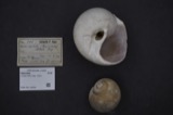
evidence. Museums hold 1,853 specimens
collected within 10 miles of Chatham Railroad Depot between 1840 and
1975: 800 Plantae, 793 Animalia, 163 Fungi, 44 Bacteria, 40 Unrecorded, 13 Chromista. 12 distinct Species records are shown.
Collected by A. B. Seymour, A. Pealey, A. R. Hodgdon and others. Each is a
physical object with a catalogue
number, and each entry opens the museum's record. This is what was
collected and kept, not a survey of what lives here - nothing can be
concluded from a species being absent.
Regional context, not property-specific
evidence. The federal mineral resources record lists
2 workings within 5 miles of Chatham Railroad Depot: 1 past producer, 1 producer.
1 still produces. What was taken out: Sand and Gravel, Construction. Distance is straight-line from the
map coordinates, so a quarry counted here may appear on a neighbouring
settlement's page as well.
Regional context, not property-specific
evidence. The National Weather Service names
Chatham, the town this property stands in, in 5 storm reports between 1999 and 2019: 2 flood, 1 heavy rain, 1 flash flood, 1 thunderstorm wind.
No death or injury is recorded in these reports. Each account below is quoted exactly as the forecast office
filed it, from the NOAA Storm Events Database, and each date
opens the federal record of that event.
In Chatham, a NWS survey found numerous large trees uprooted, consistent with 90+ mph microburst straight line winds, which is what remained after the Harwich tornado lifted. Two utility poles were leaning on Morris Island Road with one snapped in half and wires hanging low to the ground. A mesonet site reported a gust to 85 mph at 1115 AM EST (1215 PM EDT). Emergency management cited $426,000 in costs for the town to clean debris from roadways. Total damage estimates are much higher, accounting for individual homeowner and business claims.
At 112 AM EST, the Chatham Town Hall basement and parking lot were reported to be flooded. At 300 AM EST, the Automated Surface Observation platform at Chatham Airport reported storm total rainfall of 5.27 inches.
Several roads experienced street flooding, closing the roads. These included: Orleans Road at Frost Fish Road, Stepping Stones at Heritage Lane, Commerce Park South, Main Street near the Chatham Motel, and Route 28 near Stoney Hill Road.
No historic map-sheet match is published
for this property yet. That does not mean no map exists. This record needs
a coordinate-quality review before it can be joined to a sheet boundary.
Browse the county's mapped places while that work is
pending.
From the nomination file
2,036 words on record
When this property was proposed for the
National Register, someone wrote the case for it: what the building is,
and why it matters. That document is a federal record in the public domain.
It is quoted below word for word, never summarised. The text was read off the scanned case file by machine, so the
occasional stray character is the recogniser's and the 1970s
typewriter's.
Description of the property
The Chatham Railroad Depot is located on Depot Road on the outskirts of Chatham. The building sits on its original site and is presently surrounded by contemporary structures. A low hedge separates the ¼ acre of property from the street. The Queen Anne/Stick Style depot was constructed in 1887. It is a 1½ story, gable root, rectangular structure with a hexagonal tower rising from the north (rear) elevation. The symmetrical building is painted yellow with maroon trim. A molded stringcourse ties the window cornices together and defines the difference in exterior sheathing. The lower portion of the building is clapboards; the upper is flat boards. The overhanging eaves are supported by large brackets, which are flanked by a boss creating an unusual and ornamental entablature.
The roof is covered with cedar shingles. Fenestration is 2/2 framed by wide, flat architraves. The south facade has a centrally located, one-story projection with a shed roof. Ihis small section has four windows and is flanked by a five panel entrance door to either side on the main body of the building. These doors are headed by single light transoms. A single window stands at either end of the facade. The east and west elevations each have a double window on the first story and a small triple arched window in the gable. The north (rear) elevation is identical to the facade with the addition of the central tower. The ground level of the tower is a three-sided bay. Four windows occupy the bay, each with a molded panel below. These windows are headed by the Chatham Depot sign.
The portion of the tower rising from the buiiding roof is divided into four sections. The first is sheathed in a clapboard-diapered shingle-clapboard pattern.
/ARCHITECT David Howes, Builder The Chatham Railroad Depot is significant as the only remaining railroad station on Cape Cod in its original condition, and as a good example of late 19th century Queen Anne/Stick Style architecture. The depot was constructed by David Howes, builder, for the Chatham Railroad Company and Old Colony Railroad Company in 1887. The establishment of a rail line to Chatham increased both the infant tourist trade and the amount of commercial goods shipped to and from the town. The railroad contributed largely to the gradual shift in Chatham's economy from one dependent on salt water trades and agriculture to one dependent on tourism and construction.
Despite numerous attempts to attract a railroad to Chatham prior to 1887, no company was willing to underwrite a small branch line to only one town. The Chatham Railroad Co. was organized by several citizens with the support of town officials in the winter of 1886-87. The main purpose of the organization was to raise funds to build a line connecting with the main line of the Old Colony Railroad that ran through Harwich center. The company was open to anyone who wished to buy shares in it. The majority of shareholders were a few individuals; the town of Chatham was the largest single shareholder. The Chatham Railroad Co. purchased land for the line, but the actual railroad was built by the Old Colony Co. between May and November 1887.
The line opened for business in November 1887 and ran a distance of seven miles. The Chatham Railroad Co. owned the depot and railyard with a repair shop, turntable and watertower. They also owned a small station at South Chatham, but they never owned any rolling stock; they rented the land from the Old Colony Co. which provided all services.
Quoted from the National Register nomination
for reference 78000422, 12 pages, held by the National Archives in Record
Group 79. See the
catalogue record.
Listed places nearby
6 within 8 miles
Other National Register properties close
enough to walk or drive between, ordered by distance from this one. Both
positions come from the same geocoding pass that matched these properties
to their map sheets.
Listing record. National Park Service National Register of Historic Places, listed-properties dataset, current to 2026-05-22.
Map join. Address geocoded through the United States Census geocoder, then tested against the published boundary of every sheet in the USGS Historical Topographic Map Collection.
How this page is made. Listing fields come from federal records; map-sheet coverage is a labelled coordinate-to-boundary calculation, not a source-field claim.
Wildfire. Short, Karen C. 2022. Spatial wildfire occurrence data for the United States, 1992-2020 [FPA_FOD_20221014]. 6th Edition. Fort Collins, CO: Forest Service Research Data Archive. https://doi.org/10.2737/RDS-2013-0009.6 Collected with United States Government funding and usable without additional permissions or fees.
Specimens. Global Biodiversity Information Facility (GBIF), https://www.gbif.org/. Only records licensed CC0 or CC BY are used. Records licensed CC BY-NC are excluded because this site carries advertising. Images are checked individually and any whose licence is non-commercial, no-derivatives or unreadable is refused.
Mines and quarries. USGS Mineral Resources Data System (MRDS) https://mrdata.usgs.gov/mrds/ A work of the United States government, no copyright under 17 U.S.C. 105.
Storms. NOAA National Centers for Environmental Information, Storm Events Database https://www.ncei.noaa.gov/stormevents/ A work of the United States government, no copyright under 17 U.S.C. 105. Narratives are quoted verbatim from the National Weather Service report and are not edited or summarised.
 Block
Block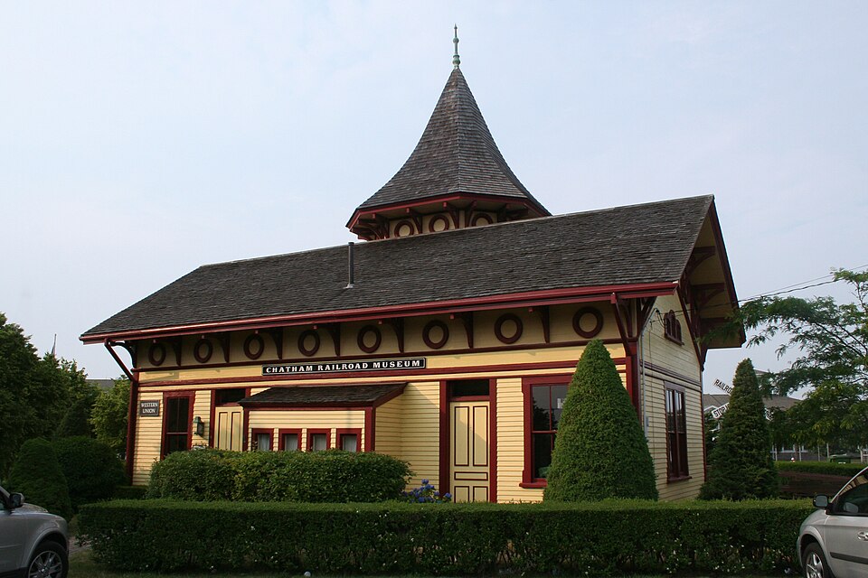


.jpeg)