Listed on the National Register of Historic Places in
1979. A historic map-sheet match is not published yet. The record needs a coordinate-quality review before it can be joined to a sheet boundary.
From the record
“The first goods sold in this town were by John Wheeler, who was for many years engaged in merchandising at Bladensburg. He took great delight in tlie militia trainings, being a captain ; in the Christian church, being an elder ; in the Whig party, being a committee-man.”
A History of Knox County, Ohio, from 1779 to 1862 Inclusive; Comprising Biographical Sketches, Anecdotes .. (1862). Machine-read text.
one of 35 National Register listings in Knox County · listed in 1979 · category: Structure.
National Register reference number.79001869- the number the National Park Service assigned this property when it was listed, and the key its nomination file is catalogued under at the National Archives.
In 1816, there were 35 voters. Jacob Lepley was the first lister, and Abraham Carpenter first appraiser. This, the south-eastern township of the countv, is watered bv the Wakatomika ; the ground is generally rolling, but quite productive. In 1830 the inhabitants numbered 626 ; in 1810, 991 ; in 1850, 1,080 ; in 1860, 960. The only town and post-office is Bladensburg ; it contains 200 inhabitants.
The first goods sold in this town were by John Wheeler, who was for many years engaged in merchandising at Bladensburg. He took great delight in tlie militia trainings, being a captain ; in the Christian church, being an elder ; in the Whig party, being a committee-man. In all respects, long was John Wheeler a good citizen ; lie now lives, at an advanced age, in Iowa. The second store was carried on by W. Houck, who for twelve years sold goods. T. Axtell, Peter Berry, James Loveridge, Alphonso Byam, T. & 0. L. Marquand, have also sold goods there. The present merchants are, Mark Hammond and Samuel Richard.
Regional context, not property-specific
evidence. The
federal wildfire occurrence database
lists 12 fires within 5 miles of Mill Road Bowstring Bridge between
2009 and 2020, burning about 16 acres in total. None started naturally. None was recorded as arson.
Distance is straight-line from the map coordinates, so a fire counted
here may appear on a neighbouring settlement's page as well.
Reported cause
Fires
Debris and open burning
5
Missing data/not specified/undetermined
4
Equipment and vehicle use
1
Power generation/transmission/distribution
1
Recreation and ceremony
1
The most recent of
them, most recent first, with the day each was reported and the service
that recorded it.
Regional context, not property-specific
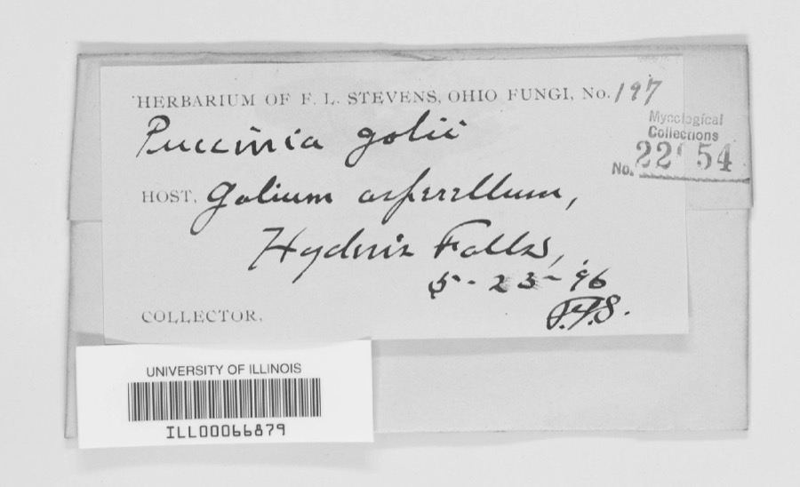
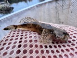
evidence. Museums hold 216 specimens
collected within 10 miles of Mill Road Bowstring Bridge between 1890 and
1975: 188 Animalia, 20 Plantae, 8 Fungi. 12 distinct Species records are shown.
Collected by Cobonus, Collector unknown, Collector unspecified and others. Each is a
physical object with a catalogue
number, and each entry opens the museum's record. This is what was
collected and kept, not a survey of what lives here - nothing can be
concluded from a species being absent.
Regional context, not property-specific
evidence. The National Weather Service names
Bladensburg, the town this property stands in, in 5 storm reports between 1995 and 2024: 3 thunderstorm wind, 2 hail.
No death or injury is recorded in these reports. Each account below is quoted exactly as the forecast office
filed it, from the NOAA Storm Events Database, and each date
opens the federal record of that event.
No historic map-sheet match is published
for this property yet. That does not mean no map exists. This record needs
a coordinate-quality review before it can be joined to a sheet boundary.
Browse the county's mapped places while that work is
pending.
From the nomination file
1,571 words on record
When this property was proposed for the
National Register, someone wrote the case for it: what the building is,
and why it matters. That document is a federal record in the public domain.
It is quoted below word for word, never summarised. The text was read off the scanned case file by machine, so the
occasional stray character is the recogniser's and the 1970s
typewriter's.
Description of the property
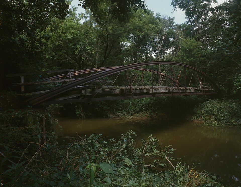
together to form a single rigid hollow tube. Wooden planking covers the roadway and is supported by iron beams, which are in turn CONDITION UNEXPOSED EXCELLENT FAIR RUINS GOOD The overall width of the structure is about nineteen feet with a roadway that is sixteen although there are no overhead bracing members.At intervals of about eight feet, most unique elements of this bridge and are composed of four iron plates fastened rise to a height of six feet six inches in the center of the bridge and are braced The bridge is about seventy five feet long, with a clear span of about seventy feet.
fill to achieve a height of about fifteen feet above the stream level.A metal plate CHECK ONE The two compression tubes bear the name of the Phoenix Iron Co.,Phila.,Pa.at regular by new guardrails or damaged by collisions. a gradual embankment from the west toward the creek.Trees and brush line the banks of laterally by a series of small diagonal struts on each side and by the roadway itself, a mile northwest of here. rusting, although the structure itself appears to be intact and has not been altered X_UNALTERED isa woods and to the south isa farmhouse and barns.The village of Bladensburg is about the creek, but fields are located in the flood plain adjacent to the stream.
To the north DATE The Mill Road Bridge is an iron bowstring arch-truss bridge that spans Wakatomika Creek The bridge is now closed to vehicular traffic and is in poor condition.Much of the outward intervals along their length anda patent date of June 16,1862.They are perhaps the identifies the builder and has a patent date of April (last digit is missing). - PERIOD AREAS OF
Statement of significance
This bridge is a rare example of a metal bowstring arch-truss bridge, a type that Whipple in 1841. The Wrought Iron Bridge Company of Cantón, fabricators of this bridge, When this bridge was constructed here, an active mill and other structures served to 1400-1499 1500-1599 1700-1799 EDUCATION ART RELIGION ARCHEOLOGY-HISTORIC SCIENCE ARCHITECTURE LAW ARCHEOLOGY-PREHISTORIC AGRICULTURE 1900- THEATER TRANSPORTATION SIGNIFICANCE SCULPTURE MILITARY _COMMUNICATIONS LITERATURE INDUSTRY the handful of bowstring arch-truss bridges that survive today in Ohio. _EXPLORATION/SETTLEMENT reinforced concrete, coupled with greater weight requirements have virtually eliminated durability, resistance to corrosiveness, and working loads for wrought iron structures.
The Phoenix Iron Company was a major innovator in the use of iron in engineering bridge had been supplanted by more durable iron box trusses.High strength steel and house remains in this vicinity along this lightly travelled road.The decline of the Wrought Iron Bridge Company patents. By the turn of the century, the bowstring arch-truss this company's patented designs for compression members, but soon after, invented their settlement and the cessation of the mill operation have enabled this bridge to be among single, double and triple intersection Pratt through trusses; combination trusses; and bridge company with patented partsbya nationally significant iron fabricator.
Southern, and Southwestern states.Their Book of Designs of Wrought Iron Bridges one of the leading and widest ranging metal bridge fabrication firms in the nation. represents an import^segment of engineering history, that was constructed by a leading _CONSERVATION They circulated agents and erected structures throughout the New England, Eastern Midwest, 70's.Job Abbott was the vice-president and chief engineer and Michael Adler was the history of iron bridge buildings in Europe and America, and articles on the strength, this type of bridge in Ohio. -PHILOSOPHY published in 1874 included a variety of bowstring arches; deck arches; low trusses; -_ECONOMICS SPECIFIC DATES c.
Quoted from the National Register nomination
for reference 79001869, 11 pages, held by the National Archives in Record
Group 79. See the
catalogue record.
Listed places nearby
1 within 8 miles
Other National Register properties close
enough to walk or drive between, ordered by distance from this one. Both
positions come from the same geocoding pass that matched these properties
to their map sheets.
Listing record. National Park Service National Register of Historic Places, listed-properties dataset, current to 2026-05-22.
Map join. Address geocoded through the United States Census geocoder, then tested against the published boundary of every sheet in the USGS Historical Topographic Map Collection.
How this page is made. Listing fields come from federal records; map-sheet coverage is a labelled coordinate-to-boundary calculation, not a source-field claim.
Wildfire. Short, Karen C. 2022. Spatial wildfire occurrence data for the United States, 1992-2020 [FPA_FOD_20221014]. 6th Edition. Fort Collins, CO: Forest Service Research Data Archive. https://doi.org/10.2737/RDS-2013-0009.6 Collected with United States Government funding and usable without additional permissions or fees.
Specimens. Global Biodiversity Information Facility (GBIF), https://www.gbif.org/. Only records licensed CC0 or CC BY are used. Records licensed CC BY-NC are excluded because this site carries advertising. Images are checked individually and any whose licence is non-commercial, no-derivatives or unreadable is refused.
Storms. NOAA National Centers for Environmental Information, Storm Events Database https://www.ncei.noaa.gov/stormevents/ A work of the United States government, no copyright under 17 U.S.C. 105. Narratives are quoted verbatim from the National Weather Service report and are not edited or summarised.
 Block
Block