BlockBefore
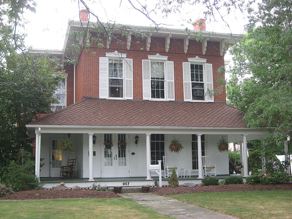
Photograph of Ambrose Cory House
Photograph by Nyttend, Public domain. Via Wikimedia Commons.

Cory, Ambrose, House

Listed on the National Register of Historic Places in 1979. A historic map-sheet match is not published yet. The record needs a coordinate-quality review before it can be joined to a sheet boundary.

From the record

one of 35 National Register listings in Seneca County · listed in 1979 · category: Building.

Sources: the case file at the National Archives · the National Register database, National Park Service

The listing

  • What is counted as historic. The nomination lists 1 building, 1 structure as contributing to the listing.
  • Address. 957 N. Union St., Fostoria, 44830
  • When was it listed? 1979-06-20
  • Category. building
  • Township. Fostoria city
  • National Register reference number. 79001942 - the number the National Park Service assigned this property when it was listed, and the key its nomination file is catalogued under at the National Archives.

Specimens collected near this property

11 of 13 shown

Regional context, not property-specific evidence. Museums hold 13 specimens collected within 10 miles of Cory, Ambrose, House between 1901 and 1961: 8 Animalia, 4 Fungi, 1 Chromista. 11 distinct Species records are shown. Collected by Chidester, D. (Dale), Cunningham J. L., Cunningham, J. L. and others. Each is a physical object with a catalogue number, and each entry opens the museum's record. This is what was collected and kept, not a survey of what lives here - nothing can be concluded from a species being absent.

Image SpeciesYear Collected by Where, as recorded
A photograph of the species Bombus impatiens, not of this specimenBombus impatiens Cresson, 18631901not recordedKansas
A photograph of the species Ascaris equorum, not of this specimenAscaris equorum Goeze, 17821928Kinsley LabsKansas City
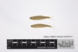
A photograph of the species Catostomus commersonii, not of this specimenCatostomus commersonii (Lacepède, 1803)1929Trautman, M. B. (Milton Bernard)East Branch Wolf Creek, within central Hopewell township, near Tiffin, Hopewell township
A photograph of the species Notropis umbratilis, not of this specimenNotropis umbratilis (Girard, 1856)1929Trautman, M. B. (Milton Bernard)East Branch Wolf Creek, within central Hopewell township, near Tiffin, Hopewell township
A photograph of the species Sylvilagus floridanus, not of this specimenSylvilagus floridanus (J.A.Allen, 1890)1939Goodpaster, W.Fostoria
A photograph of the species Minytrema melanops, not of this specimenMinytrema melanops (Rafinesque, 1820)1950Chidester, D. (Dale)Wolf Creek, Sec 19 of Liberty township, ~1.9 mi E of Amsden, Liberty township
Phytophthora infestans (Mont.) de Bary1958Cunningham, J. L.Alvada
Erysiphe cichoracearum DC.1961Cunningham J. L.Alvada
Microsphaera alni (DC.) G.Winter1961Cunningham J. L.Alvada
A photograph of the species Phyllachora graminis, not of this specimenPhyllachora graminis (Pers.) Fuckel1961Cunningham J. L.Alvada
A photograph of the species Puccinia polygoni-amphibii, not of this specimenPuccinia polygoni-amphibii Pers.1961Cunningham J. L.Alvada

All 13 specimens within 10 miles, at the Global Biodiversity Information Facility.

Mines and quarries near this property

1 within 5 miles

Regional context, not property-specific evidence. The federal mineral resources record lists 1 working within 5 miles of Cory, Ambrose, House: 1 producer. All of them still produce. What was taken out: REE. Distance is straight-line from the map coordinates, so a quarry counted here may appear on a neighbouring settlement's page as well.

Where SiteCommodity StatusRecorded
Union Carbide/ Fostoria, OhioREEProducer

Every working recorded in Seneca County

Storms near this property

47 since 1995

Regional context, not property-specific evidence. The National Weather Service names Fostoria, the town this property stands in, in 47 storm reports between 1995 and 2024: 33 thunderstorm wind, 11 hail, 1 tornado, 1 flood. No death or injury is recorded in these reports. Each account below is quoted exactly as the forecast office filed it, from the NOAA Storm Events Database, and each date opens the federal record of that event.

WhenEvent Place namedHarm What the report says
November 2002Tornado (F1)Fostoria$1,100,000After lifting in downtown Fostoria (near the Hancock County border) the tornado touched down again on the northeastern edge of Fostoria. The tornado moved northeast from this location and damaged several homes before reaching the Fostoria Airport where a hanger and office building were damaged. From the airport, the tornado continued northeast across open farmland for a few miles and finally dissipated northwest of Amsden near the intersection of County Road 3 and Township Road 172. Several more homes and barns were damaged along the last half of the tornado track. Many cars were also damaged and hundreds of trees and power poles toppled. The damage path from this tornado in Seneca County was roughly five and a half miles in length and around 25 yards in width.
July 2013Thunderstorm WindFostoria$800,000A line of thunderstorms producing winds estimated to be around 70 mph raced east across Seneca County causing widespread damage. Hundreds of trees were snapped or toppled. A lot of damage to homes and buildings was also observed. Most of this damage was from lost roofing or siding but some outbuildings were also flattened. A lot of tree damage was reported on the south side of Fostoria. A line of 15 utility poles was knocked down northeast of Republic. The damage was especially heavy in the northeast corner of the county from Reedtown north to Flat Rock. A lot of downed trees were also reported in the Attica area. Several vehicles were reported damaged in the county. Power outages were reported throughout the county. It took several days for power to be fully restored, especially across the northeast corner of the county. Many roads had to be closed because of downed trees and power lines.
August 2022Flash FloodFostoria$250,000Fostoria Police and Fire reported flash flooding across the southern half of Fostoria. All underpasses in the city were impassable with up to 5 feet of water over the roadways. Most streets on the south side of Fostoria were flooded with an average of 2 feet of water depth. Several reports of vehicles stranded in flood waters with up to 3 feet of water depth. Reports of numerous basements flooded. Trained spotter measured 3.05 inches of rain in around an hour period between 1300 LST to 1400 LST. Radar estimates of 2.5 to 3 inches of rain fell in this one hour period across Fostoria, with a peak recurrence interval of 50 years where the heaviest rain fell. Peak instantaneous rainfall rates of 3.5 inches per hour were estimated by radar.
April 2003Thunderstorm WindFostoria$150,000Thunderstorm winds downed many trees and large limbs in Tiffin and at least two large limbs in Fostoria. A couple homes in Tiffin sustained roof damage. A few cars were also damaged by fallen trees and limbs. 1,600 customers lost power in Tiffin alone.
May 2011HailFostoria$100,000Hail from penny to golf ball sized was reported. Many vehicles and a few homes were damage by the hail.
July 2006Thunderstorm WindFostoria$75,000Numerous trees were reported down throughout the city of Fostoria. Four houses and two cars sustained damage from trees falling on them. A restaurant in Fostoria had two walls knocked down causing considerable structural damage.
November 1998Thunderstorm WindFostoria$40,000Trees and power lines were downed. At least one tree fell on a garage and another on a house.
May 2007HailFostoria$25,000Golf ball size hail was observed.
August 2000Thunderstorm WindFostoria$20,000Thunderstorm winds downed many trees in Tiffin and Fostoria. A garage was damaged by a fallen tree and several billboards were knocked down in Tiffin.
April 1995Thunderstorm WindFostoria$20,000Trees and limbs were downed, some on power lines and structures. A barn north of town was damaged by the strong winds.
May 1997Thunderstorm WindFostoria$20,000no account filed
July 2003Thunderstorm WindFostoria$15,000Thunderstorm winds downed a few trees and large limbs.
February 2002Thunderstorm WindFostoria$15,000Thunderstorm winds downed two large trees. One of the trees damaged a small outbuilding.
July 2016Thunderstorm WindFostoria$12,000A large branch and power lines were brought down by thunderstorm winds in Fostoria.
May 2011Thunderstorm WindFostoria$10,000Thunderstorm winds downed a 5 inch diameter tree onto a residence in town. The estimated wind gust associated with this thunderstorm was 65 mph.
August 1997Thunderstorm WindFostoria$10,000Many trees and large branches were downed.
June 2013Thunderstorm WindFostoria$8,000Thunderstorm winds toppled a power pole.
July 2005Thunderstorm WindFostoria$8,000Several trees and large limbs were reported down.
June 2006Thunderstorm WindFostoria$6,000Several trees and utility poles were reported down.
April 2003HailFostoria$5,000Nickel size hail was observed.
April 2003HailFostoria$5,000Nickel size hail was observed five miles east of Fostoria.
August 2002Thunderstorm WindFostoria$5,000Thunderstorm winds downed trees and large limbs in Fostoria and Tiffin.
July 2000Thunderstorm WindFostoria$5,000Thunderstorm winds downed five large trees.
August 1997Thunderstorm WindFostoria$5,000Large branches and power lines were downed.
July 1997Thunderstorm WindFostoria$5,000no account filed
August 2003Thunderstorm WindFostoria$3,000Thunderstorm winds downed two large trees.
May 2004Thunderstorm WindFostoria$2,000Thunderstorm winds downed a large tree.
March 2003HailFostoria$2,000Penny size hail was observed.
July 2002Thunderstorm WindFostoria$2,000Thunderstorm winds downed several large tree limbs four miles northeast of Fostoria.
July 2002HailFostoria$2,000Dime size hail was reported three miles northeast of Fostoria.
May 2015Thunderstorm WindFostoria$1,000Thunderstorm wind gusts were estimated to be at least 60 mph. At least one large tree limb was downed.
October 2010Thunderstorm WindFostoria$1,000Thunderstorm winds estimated at 65 mph downed a large tree limb.
May 1998Thunderstorm WindFostoria$1,000Several large limbs were downed.
June 2020Thunderstorm WindFostoria$200Multiple trees were reported down in the Seneca County portion of Fostoria.
August 2024Thunderstorm WindFostoria-Trees downed in Fostoria. Damage caused by approaching and outflow-dominant thunderstorms.
June 2024Thunderstorm WindFostoria-Several trees downed in Fostoria.
August 2019Thunderstorm WindFostoria-A large tree branch was blown down.
August 2019Thunderstorm WindFostoria-Numerous trees were blown down.
July 2017FloodFostoria-On the morning of July 13 heavy rain produced some overland flooding in Seneca County. Fostoria measured 3.20 between 4-6 am. Road flooding was common across the area including US 224-west of Tiffin and SR53 south of Tiffin. Numerous local road closures occured across the county.
June 2013Thunderstorm WindFostoria-A 66 mph thunderstorm wind gust was measured by an automated sensor at Fostoria High School.
August 2011HailFostoria-Quarter sized hail was observed.
May 2011Thunderstorm WindFostoria-A trained spotter estimated thunderstorm winds at 60 mph.
May 2011HailFostoria-Nickel sized hail was observed.
June 2008Thunderstorm WindFostoria-A trained spotter estimated winds to be around 65 mph. No damage was immediately noted with the wind gusts.
June 2006HailFostoria-Penny size hail was observed.
June 2005HailFostoria-Penny size hail was observed.
July 1999HailFostoria-no account filed

Every storm recorded in Seneca County

Map coverage status

No historic map-sheet match is published for this property yet. That does not mean no map exists. This record needs a coordinate-quality review before it can be joined to a sheet boundary. Browse the county's mapped places while that work is pending.

From the nomination file

2,051 words on record

When this property was proposed for the National Register, someone wrote the case for it: what the building is, and why it matters. That document is a federal record in the public domain. It is quoted below word for word, never summarised. The text was read off the scanned case file by machine, so the occasional stray character is the recogniser's and the 1970s typewriter's.

Description of the property

This Italiarate building sits on a cut stone foundation with a stone water table. metal roof, with segmental arches in the entablature connecting the pillars. This front door, with wood columns supporting a flat roof and an open porch on the east end The interior of the house has been beautifully restored, as has the exterior with to this brick section with.a door in the second floor gable end leading out to the a stone fireplace under the roof, and a large three-car garage immediately north of the south side, and an old grape arbor in back of the house.

CONDITION DETERIORATED RUINS UNALTERED The windows have wood shutters.The front double door has a multi-light fanlight in The porch on the west end of the south side has wood pillars supporting the sloping The house is basically square in plan with a large two-story bay on the south side The windows are double-hung 6/6 with cast iron sills and decorated shaped lintels. Outbuildings include a shelter area with a gable roof supported by four pillars and on the walls contains hog's hair.Door knobs and latches are of white porcelain.

drawing in the Seneca County atlas shows a balustrade on the roof to form a widow's CHECK ONE the round arch above the door.A door off the porch on the west end of the south _UNEXPOSED This is a two-story brick building with a truncated hip asphalt roof;an 1874 of the south side with a door facing east on that side. that projects out.Arear.ll-story rectangular.section has a.gable metal roof with an side has a decorated shaped lintel like those on the windows. -EXCELLENT side.of the main house on the.south.side.of.the lk-story/brick.section: -GOOD steeply-sloping shed roof. The date of this alteration is unknown, but the owner guesses it was in the early 1900s.

Read the complete 2,051-word case file.

Statement of significance

family sold 20 acres of land to Ambrose Cory in 1860 for $2000, including this plot. That would indicate some sort of structure, probably, but' the style and quality of 1863 map of Fostoria, but only squares are used to indicate the existence of buildings, Ambrose Cory was born in Susquehanna County, Pennsylvania on May 29, 1825 and was his parents in 1832, was reared on a farm here, and received a common school education. On February 14, 1854 he married Amanda Kelly, and they had three children. The Corys lived in Perry Township until 1861 when they moved to Fostoria, presumably eighty acres in Wood County, Ohio, as well as eighteen acres of land in Fostoria on history, p. 893).

most of the block bounded by Jackson, Union, Culbertson, and County Line; Culbertson was not a through street in 1874. Cory Street, which parallels Union and County 1400-1499 ART LAW INVENTION RELIGION THEATER EDUCATION EXPLORATION/SETTLEMENT BUILDER/ARCHITECT AGRICULTURE TRANSPORTATION SIGNIFICANCE PHILOSOPHY PERIOD SCULPTURE MILITARY INDUSTRY The 1874 atlas shows Cory owning 20 acres bounded by Jackson, Union, and County PREHISTORIC This is still a recognized local landmark and was included in the Fostoria Antique Perry Township (Wood County, bordering Fostoria).

Ambrose came to Perry Township with _POLITICS/GOVERNMENT ARCHEOLOGY-HISTORIC This house is significant as an example of Italiaate architecture in Fostoria and _COMMUNICATIONS The exact date of construction is not known, as it appears likely that there might _SCIENCE pioneers in the Fostoria area, with Ambrose' cousin the first male child born in It seems to have been associated with the house since the time of Ambrose Cory and Study's first designation of historic homes in the area in 1978. - CONSERVATION _SOCIAL/HUMANITARIAN a wooded area.

Read the complete 2,051-word case file.

The whole case file for this property - 2,051 words, 20 pages, reproduced complete.

Quoted from the National Register nomination for reference 79001942, 20 pages, held by the National Archives in Record Group 79. See the catalogue record.

Sources for this property

National Archives recordThe nomination case file for reference 79001942 in Record Group 79.
Seneca CountyAll 35 listed properties in this county.

Provenance

  • Listing record. National Park Service National Register of Historic Places, listed-properties dataset, current to 2026-05-22.
  • Map join. Address geocoded through the United States Census geocoder, then tested against the published boundary of every sheet in the USGS Historical Topographic Map Collection.
  • How this page is made. Listing fields come from federal records; map-sheet coverage is a labelled coordinate-to-boundary calculation, not a source-field claim.
  • Specimens. Global Biodiversity Information Facility (GBIF), https://www.gbif.org/. Only records licensed CC0 or CC BY are used. Records licensed CC BY-NC are excluded because this site carries advertising. Images are checked individually and any whose licence is non-commercial, no-derivatives or unreadable is refused.
  • Mines and quarries. USGS Mineral Resources Data System (MRDS) https://mrdata.usgs.gov/mrds/ A work of the United States government, no copyright under 17 U.S.C. 105.
  • Storms. NOAA National Centers for Environmental Information, Storm Events Database https://www.ncei.noaa.gov/stormevents/ A work of the United States government, no copyright under 17 U.S.C. 105. Narratives are quoted verbatim from the National Weather Service report and are not edited or summarised.