BlockBefore
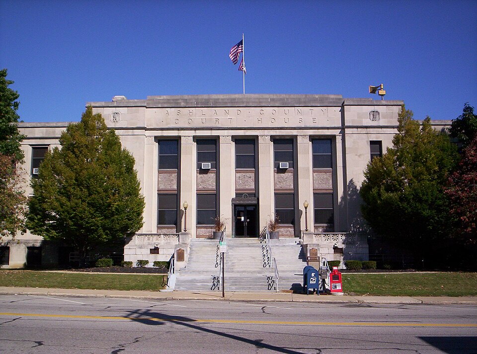
Photograph of Ashland County Courthouse
Photograph by User:OHWiki, Public domain. Via Wikimedia Commons.

Ashland County Courthouse

Built in 1929 in the Neoclassical architecture. Listed on the National Register of Historic Places in 1979. A historic map-sheet match is not published yet. The record needs a coordinate-quality review before it can be joined to a sheet boundary.

From the record

“Ashland County Courthouse was constructed from 1928-1929 on West 2nd Street in Ashland, Ohio, United States. The courthouse was added to the National Register on 1979-12-21.”

Wikipedia article Ashland County Courthouse (Ohio), CC BY-SA 4.0.

one of 11 National Register listings in Ashland County · listed in 1979 · category: Building · built in 1929, Neoclassical architecture.

Sources: the Wikipedia article · the case file at the National Archives · the National Register database, National Park Service

The listing

  • What is counted as historic. The nomination lists 1 building as contributing to the listing.
  • Address. W. 2nd St., Ashland, 44805
  • When was it listed? 1979-12-21
  • Category. building
  • Township. Ashland city
  • When was it built? 1929
  • Architectural style. Neoclassical architecture
  • National Register reference number. 79003786 - the number the National Park Service assigned this property when it was listed, and the key its nomination file is catalogued under at the National Archives.

What happened here

An account from the chapter on Ashland city, The inset identifies its exact source book and publication year.

From History of the Ashland County Pioneer Historical Society, published 1875 - Ashland City

Settlements And Improvements

The spring of 1812 saw the tide of emigration on the increase. At that period a war was impending between Great Britain and the United States. This checked the influx of the pioneers, for it was evident the Indians of the northwest would be invited to assist the enemy. In fact, it had been observed for nearly two years, that the Greentown and Jerometown or Mohican Johnstown Indians had been in the habit of making frequent visits to Upper Sandusky, and always returned with new blankets, tomahawks and ammunition in abundance.

Read the rest of this passage

The ground it stands on

900,629 words

The chapter on Ashland City in History of the Ashland County Pioneer Historical Society, published 1875 names Ashland. This is what it says, exactly as the scans read.

In order to carry out the purposes of the Ashland County Pioneer Historical Association, for the benefit of all parties interested, and by the urgent request of many of its members, as well as others who are friendly to its aims and objects, this work is published, and trust it will prove val -

Passage source: History of the Ashland County Pioneer Historical Society, published 1875.

A clear and definite statement of all the acts and transactions of the Ashland County Pioneer Historical Society from its organization till the close of the 11th Annual Meeting held at the Ashland Court House on Thursday, August 27th, 1885.

Passage source: History of the Ashland County Pioneer Historical Society, published 1875.

Machine-read from a century-old scan, so expect the errors a machine makes: misspelled names, dropped words, stray characters.

Read the whole chapter on Ashland City - 900,629 words on its settlement, mills, schools and churches.

Fires near this property

10 since 2019

Regional context, not property-specific evidence. The federal wildfire occurrence database lists 10 fires within 5 miles of Ashland County Courthouse between 2019 and 2020, burning about 23 acres in total. None started naturally. None was recorded as arson. Distance is straight-line from the map coordinates, so a fire counted here may appear on a neighbouring settlement's page as well.

Reported cause Fires
Debris and open burning6
Missing data/not specified/undetermined2
Power generation/transmission/distribution1
Equipment and vehicle use1

The most recent of them, most recent first, with the day each was reported and the service that recorded it.

DateCause SizeReported by Name on the report
26 September 2019Debris and open burningunder an acreOhio Department of Natural Resources15259
26 September 2019Debris and open burningunder an acreOhio Department of Natural Resources15267
24 September 2019Missing data/not specified/undetermined20 acresOhio Department of Natural Resources15258
9 August 2020Equipment and vehicle useunder an acreOhio Department of Natural Resources15806
21 July 2020Power generation/transmission/distributionunder an acreOhio Department of Natural Resources15789
9 June 2020Missing data/not specified/undeterminedunder an acreOhio Department of Natural Resources15777
7 November 2020Debris and open burningunder an acreOhio Department of Natural Resources15894
6 November 2020Debris and open burningunder an acreOhio Department of Natural Resources15889

Every fire recorded in Ashland County

Specimens collected near this property

12 of 303 shown

Regional context, not property-specific evidence. Museums hold 303 specimens collected within 10 miles of Ashland County Courthouse between 1846 and 1973: 280 Animalia, 20 Plantae, 3 Fungi. 12 distinct Species records are shown. Collected by A. S. Percival, Auten, B Zahuranec & party and others. Each is a physical object with a catalogue number, and each entry opens the museum's record. This is what was collected and kept, not a survey of what lives here - nothing can be concluded from a species being absent.

Image SpeciesYear Collected by Where, as recorded
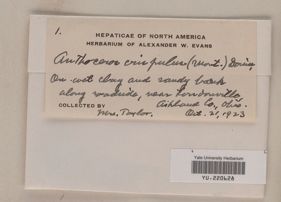
Specimen of Anthoceros crispulus (Mont.) DouinAnthoceros crispulus (Mont.) Douin1923Mrs. Bayard R. Taylornear Londonville
Mediorhynchus grandis Van Cleave, 19161846P. HarwoodAshland
A photograph of the species Ammodramus savannarum, not of this specimenAmmodramus savannarum (J.F.Gmelin, 1789)1897Smith, D. W.Ashland, Ashland, Ohio, USA
A photograph of the species Danthonia spicata, not of this specimenDanthonia spicata (L.) Roem. & Schult.1897Collector(s): Edwin Lincoln MoseleyVermilion Township
A photograph of the species Smilax tamnoides, not of this specimenSmilax tamnoides L.1899Selby, A.D.Red Haw
A photograph of the species Tyto alba, not of this specimenTyto alba pratincola (Bonaparte, 1838)1900Fuller, W. J.Sullivan, Ashland, Ohio, USA
A photograph of the species Thamnophis sirtalis, not of this specimenThamnophis sirtalis (Linnaeus, 1758)1902not recordedNo Further Locality Data
Valsa Fr.1913Stevens N. E.Windsor
A photograph of the species Conocephalus attenuatus, not of this specimenConocephalus attenuatus (Scudder, 1869)1925Pallister, J. C. (John C.)Vermilion River, TR 608 RM 62.1, 1.14 miles west of Savannah OH, Clear Creek township
A photograph of the species Bombus impatiens, not of this specimenBombus impatiens Cresson, 18631927not recorded
Sternotherus odoratus (Latreille, 1802)1927Drumm, J. C.Long Lake, Ashland Co., Ohio
Trionyx spiniferus Lesueur, 18271927Drumm, J. C.Long Lake, Ashland Co., Ohio

All 303 specimens within 10 miles, at the Global Biodiversity Information Facility.

Storms near this property

60 of 85 shown

Regional context, not property-specific evidence. The National Weather Service names Ashland, the town this property stands in, in 85 storm reports between 1995 and 2025: 47 thunderstorm wind, 29 hail, 5 flash flood, 2 lightning. The reports record 4 injuries. Each account below is quoted exactly as the forecast office filed it, from the NOAA Storm Events Database, and each date opens the federal record of that event.

WhenEvent Place namedHarm What the report says
August 2000Tornado (F1)Ashland4 hurt, $2,000,000A tornado touched down on the west side of Ashland near Lindale Avenue then moved east along West Main Street causing significant damage and four minor injuries. The damage path was 50 to 100 yards wide, intermittent and nearly three miles in length. The most severe damage occurred a few blocks west of downtown. Major structural damage occurred to several homes in the area including one that had an entire side blown apart. Damage to the downtown business district was much less severe with most of the damage being in the form of broken windows and torn off siding. However, three buildings lost large sections of roof and a fourth had a brick wall collapse. The roof of one of the buildings was found six blocks east of downtown. East of the business district, the damage path was intermittent with only a dozen or so homes sustaining minor damage. In total, 112 homes and 20 businesses were damaged. Of those totals, 23 homes and four businesses suffered major damage. Several cars were destroyed and hundreds of trees were toppled. Six power poles were also snapped near ground level.
August 2007Thunderstorm WindAshland$300,000A portion of a roof on a grocery store was blown off. The grocery store was located on the north side of Ashland. Trees were also reported down in the area. A survey team followed up on the report and found a significant portion of the grocery store's roof was blown off. Also noted was a barn southwest of the store that had a portion of its roof blown off. Numerous trees were down mainly between State Routes 511 and 58. Two semi trailers and a construction trailer were blown onto their sides near State Route 511 and U.S. 250.
July 2003Flash FloodAshland$250,000Thunderstorms dumped two to threes of rain on the central portion of Ashland County in about 90 minutes. Lowland and urban flooding occurred over the northern half of the city of Ashland. A mobile home park was under as much as two feet of water during the peak of the storm. Many streets had to be closed in Ashland because of flooding. Dozens of homes experienced basement flooding. Several cars were also damaged by flood waters. State Route 302 was closed for several hours to the west of Nankin.
September 2007Thunderstorm WindAshland$100,000Straight line winds created a damage path about one hundred yards wide and about four miles long. Along this path, numerous trees and large limbs were reported down. Several buildings had roof damage, and a box trailer was blown over by the severe winds.
November 2013Thunderstorm WindAshland$50,000Thunderstorm winds downed trees and limbs throughout Ashland County.
June 2013Thunderstorm WindAshland$50,000Thunderstorm winds downed trees throughout Ashland County.
October 1999Thunderstorm WindAshland$50,000Over a dozen large trees were downed, many of them on the campus of Ashland University. A tree fell on a house and adjacent garage. Branches from the tree punctured the roof of the house allowing heavy thunderstorm rains to seep inside. A second garage nearby also sustained major roof damage and a third house lost part of a back porch to the high winds.
September 2001Thunderstorm WindAshland$40,000Thunderstorm winds downed several trees just north of Ashland. One of the trees struck two parked cars and caused significant damage.
June 2000Thunderstorm WindAshland$35,000Thunderstorm winds downed many trees and power lines in Ashland. A two foot diameter tree fell on a house on the south side of Ashland and caused significant damage.
May 2007Flash FloodAshland$30,000Heavy rainfall occurred from numerous thunderstorms across the area during the late afternoon and evening hours. As a result, flash flooding occurred over northern Ashland County. Law enforcement reported that numerous state and U.S. routes in the area were closed because of the quickly rising and flowing water.
November 2017Thunderstorm WindAshland$25,000Thunderstorm winds downed a few trees and large limbs across Ashland County. Around 100 homes lost power as a result of the downed trees.
August 2005Thunderstorm WindAshland$25,000Numerous trees were reported down in an area from just west of Ashland eastward to the Wayne County border.
June 2002Thunderstorm WindAshland$25,000Thunderstorm winds downed many trees. A store building was slightly damaged by flying debris.
May 2011HailAshland$20,000Half dollar sized hail was reported during this thunderstorm. Several vehicles were damaged by hail.
November 2002Thunderstorm WindAshland$20,000Thunderstorm winds downed several trees on the west side of Ashland.
May 1998LightningAshland$20,000Lightning struck and touched off a blaze at a house.
July 2014Thunderstorm WindAshland$15,000A thunderstorm downburst downed a couple of trees south of Ashland. Scattered power outages were reported in the area.
August 2012Thunderstorm WindAshland$15,000Numerous trees reported down in the city and outskirts.
May 2011HailAshland$15,000Thunderstorms produced a swath of penny to quarter sized hail.
May 2011Flash FloodAshland$15,000Strong thunderstorms brought wind, hail, and torrential rain to Ashland County on the evening of the 14th. Doppler Radar estimated as much as 2 inches fell within two hours over northern portions of the county. The result was several roads flooded. Flood damage closed County Road 1302 between U.S. 42 and Township Road 753 in Montgomery Township.
April 2002HailAshland$15,000Dime to quarter size hail was reported just west of Ashland.
May 2011HailAshland$10,000Thunderstorms produced quarter sized hail.
July 2006Thunderstorm WindAshland$10,000Numerous trees were reported down.
July 2006HailAshland$10,000Quarter size hail was observed. Also, several trees were reported down.
June 2004Thunderstorm WindAshland$10,000Thunderstorm winds downed a few trees in the county.
July 2003Thunderstorm WindAshland$10,000Thunderstorm winds downed trees and limbs five miles north of Ashland.
August 2003Thunderstorm WindAshland$10,000Thunderstorm winds downed several trees.
April 2023Thunderstorm WindAshland$8,000Large tree limbs downed and an outbuilding's roof was blown off in Ashland.
June 2022Thunderstorm WindAshland$8,000Shingles blown off roof about four-miles east of Ashland.
July 2003Thunderstorm WindAshland$8,000Thunderstorm winds downed one tree and several large limbs.
March 2017Thunderstorm WindAshland$6,000A line of thunderstorms moved across Ashland County downing a few trees.
April 2013Thunderstorm WindAshland$6,000A trained weather spotter reported numerous tree limbs down from strong thunderstorm winds within the city of Ashland.
July 2013Thunderstorm WindAshland$5,000Thunderstorm winds downed several large tree limbs.
June 2012Thunderstorm WindAshland$5,000Thunderstorm winds downed at least four trees in the county.
July 2008Thunderstorm WindAshland$5,000Thunderstorm winds downed a few trees.
October 2001Thunderstorm WindAshland$5,000Thunderstorm winds downed one tree two miles northwest of Ashland and a second in Polk.
June 1998Thunderstorm WindAshland$4,000Many trees were downed south of Ashland.
May 2014Thunderstorm WindAshland$3,000A trained weather spotter reported a tree down at a residence.
June 1998Thunderstorm WindAshland$3,000Several trees were downed and shingles were blown from a roof just northwest of the city of Ashland.
August 2019Thunderstorm WindAshland$2,000Several trees and power lines were blown down at Brookside Park in Ashland.
May 2014Thunderstorm WindAshland$2,000Thunderstorm winds downed a couple of trees in the Ashland area.
May 2011Thunderstorm WindAshland$2,000Thunderstorm winds downed two large trees.
June 2007Thunderstorm WindAshland$2,000Three trees were blown down.
May 2006Thunderstorm WindAshland$2,000Several trees were reported down.
July 2005Thunderstorm WindAshland$2,000A few large limbs were reported down.
April 2004HailAshland$2,000Quarter size hail was observed about two miles northeast of Ashland.
June 2017Thunderstorm WindAshland$1,000Thunderstorm winds downed a tree.
June 1996Thunderstorm WindAshland$1,000no account filed
June 1996LightningAshland$1,000no account filed
May 2025Thunderstorm WindAshland-Several trees downed in Ashland.
February 2024HailAshland-Hail up to penny-size in Ashland.
January 2023Thunderstorm WindAshland-A few trees and large tree limbs downed in Ashland.
March 2023Thunderstorm WindAshland-Large tree limbs downed and roof blown off outbuilding in Ashland.
April 2023Thunderstorm WindAshland-Large trees downed in Ashland area.
April 2023Thunderstorm WindAshland-Numerous trees downed near OH-511 and OH-60 on southeast side of Ashland.
August 2023HailAshland-Hail up to half dollar-size about two-miles south of Ashland.
June 2022Thunderstorm WindAshland-Extensive tree and power pole damage in Ashland.
July 2021Thunderstorm WindAshland-Two trees down about two-miles west of Ashland.
July 2019Flash FloodAshland-Heavy rain fell over Ashland Ohio on the afternoon of the 21st. The rain peaked around 630 PM with 1.75 in 25 minutes. Flooding was reported across the area with creeks coming out of banks. Town Run in northwest Ashland flooded the golf course causing damages and flooded Brookside Drive. In Olivesburg water was overrunning Route 603 from a tributary to the Whetstone Creek. One motorists had to be rescued.
February 2019FloodAshland-Moderate to heavy rainfall of 1 to 1.5 inches across the central highlands of Ohio resulted in flooding of dozens of roads in Ashland, Knox, Morrow, Richland, and Holmes Counties. In Ashland and Richland Counties flooding occurred outside of the normal flooded locations. No properties were inundated. Most impacts were in Ashland and Mansfield.

Every storm recorded in Ashland County

Newspapers printed here

0 digitised pages

3 papers published in this town, digitised by the Library of Congress and free to read: 0 issues, 0 pages. Every page is searchable, so a name or a street can be looked for directly in what the town printed about itself at the time.

NewspaperPublished
The Ohio Union1849 to 1854
The Ashland Union1854 to 1868
The States and Union1868 to 1872

Map coverage status

No historic map-sheet match is published for this property yet. That does not mean no map exists. This record needs a coordinate-quality review before it can be joined to a sheet boundary. Browse the county's mapped places while that work is pending.

From the nomination file

1,609 words on record

When this property was proposed for the National Register, someone wrote the case for it: what the building is, and why it matters. That document is a federal record in the public domain. It is quoted below word for word, never summarised. The text was read off the scanned case file by machine, so the occasional stray character is the recogniser's and the 1970s typewriter's.

Description of the property

although it is located on a small rise, a view of the courthouse from Main Street is probably be accounted for because Ashland County was one of the last formed in Ohio, The courthouse is basically in the shape of a large rectangle, but with slight projections The exterior ornament is severely simple, although classical in derivation. The basement building is through a very shallow two story portico set in antis by large pilasters. continues on the sides and rear, with additional grade level entrances on these sides. vestibule is a large public space richly ornamented with a coffered ceiling, marble The only other structure on the block is a civil war monument constructed of granite and about twenty feet high.

Erected in the late nineteenth century, the monument is typical of those erected in northern cities following the Civil War. CONDITION DETERIORATED The walls rise up to form parapets around the building, concealing a flat composition roof. light gray Indiana limestone, laid up in large smooth slabs creating crisp planar surfaces.

XUNALTERED blocked by commercial buildings.This secondary location of the county courthouse can XORIGINAL SITE excellent condition with virtually no changes, a single exception being that suspended The Ashland County Courthouse is a large public building located just northwest of across the front and.five bays wide on the sides.,It isa masonry.building faced with unlike other nearby county seats, the courthouse is not located on or adjacent to a CHECK ONE - UNEXPOSED - MOVEDDATE ceilings have been introduced in some of the offices.

Ashland's commercial center.The building is situated in the center of a small city panelling with brass trim and four large chandeliers.The second floor.hallway has a large skylight overhead.The corridors and public spaces have terrazo floors with -GOOD -FAIR years after this town was originally laid out.

Read the complete 1,609-word case file.

Statement of significance

The Ashland County Courthouse is a major architectural landmark in Ashland, has important added prominence. The scale and ornament, along with the building's frequent public this style is derived largely from the Greek Revival, sharing many common elements and perfected in the Greek Revival style. Like buildings in the Greek Revival style, this a dome, a large clock and the ubiquitous statue of the Goddess of Justice. Economy must have also been a factor in the design of the building.-For even with its simple, restrained appearance and functional arrangement of spaces, a major criticism of the project was launched by Judge Mansfield, a member of the building conmittee, who after state inspectors condemned the old courthouse, a bond issue of $325,000 was Martin L.

Davey, candidate for governor of Ohio, and the building was completed the 1928-29 ENGINEERING ECONOMICS CONSERVATION ARCHEOLOGY-HISTORIC AGRICULTURE SCIENCE PERIOD THEATER COMMUNICATIONS ART POLITICS/GOVERNMENT SIGNIFICANCE INDUSTRY INVENTION EDUCATION 1900- EXPLORATION/SETTLEMENT COMMERCE Stylistically, the Ashland County Courthouse reflects the stripped Neoclassicism popular LITERATURE following year.

raised basement story as a base, the groupings of windows between pilasters and the PREHISTORIC Neoclassical or Art Deco courthouse architecture.It is one of Ashland's largest public thirty years earlier, became the county seat.A small Methodist Church on this site was first used as the courthouse for several years.In 1852 a brick courthouse was erected capping of the building with a simple massive entablature are all techniques that were -TRANSPORTATION buildings and its location on a rise in the center of a city block gives the building - 1700-1799 -1500-1599 of money...(and) there are altogether too many restrooms."* complained that"the building is too ornamental......the terrace(is) an entire waste -1600-1699 -1400-1499 *Report of the Building Committee for the new Ashland County Courthouse."1928.

The first effort to build a new courthouse was in 1914.

Read the complete 1,609-word case file.

The whole case file for this property - 1,609 words, 11 pages, reproduced complete.

Quoted from the National Register nomination for reference 79003786, 11 pages, held by the National Archives in Record Group 79. See the catalogue record.

Listed places nearby

5 within 8 miles

Other National Register properties close enough to walk or drive between, ordered by distance from this one. Both positions come from the same geocoding pass that matched these properties to their map sheets.

Photograph PropertyDistance Listed
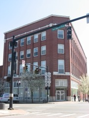
Myers Block--Home Company Building0.2 miles1997
Anderson Schoolhouse2.9 miles1977
Hayesville Opera House7.3 miles1976
Vermilion Institute7.4 miles1978
Kelley, William, Hardware Store--Hayesville Odd Fellows Hall7.4 miles2017

Sources for this property

National Archives recordThe nomination case file for reference 79003786 in Record Group 79.
Wikipedia articleCommunity-written account of this property, licensed CC BY-SA.
Ashland CountyAll 11 listed properties in this county.

Provenance

  • Listing record. National Park Service National Register of Historic Places, listed-properties dataset, current to 2026-05-22.
  • Map join. Address geocoded through the United States Census geocoder, then tested against the published boundary of every sheet in the USGS Historical Topographic Map Collection.
  • How this page is made. Listing fields come from federal records; map-sheet coverage is a labelled coordinate-to-boundary calculation, not a source-field claim.
  • Wildfire. Short, Karen C. 2022. Spatial wildfire occurrence data for the United States, 1992-2020 [FPA_FOD_20221014]. 6th Edition. Fort Collins, CO: Forest Service Research Data Archive. https://doi.org/10.2737/RDS-2013-0009.6 Collected with United States Government funding and usable without additional permissions or fees.
  • Specimens. Global Biodiversity Information Facility (GBIF), https://www.gbif.org/. Only records licensed CC0 or CC BY are used. Records licensed CC BY-NC are excluded because this site carries advertising. Images are checked individually and any whose licence is non-commercial, no-derivatives or unreadable is refused.
  • Storms. NOAA National Centers for Environmental Information, Storm Events Database https://www.ncei.noaa.gov/stormevents/ A work of the United States government, no copyright under 17 U.S.C. 105. Narratives are quoted verbatim from the National Weather Service report and are not edited or summarised.