











BlockBefore
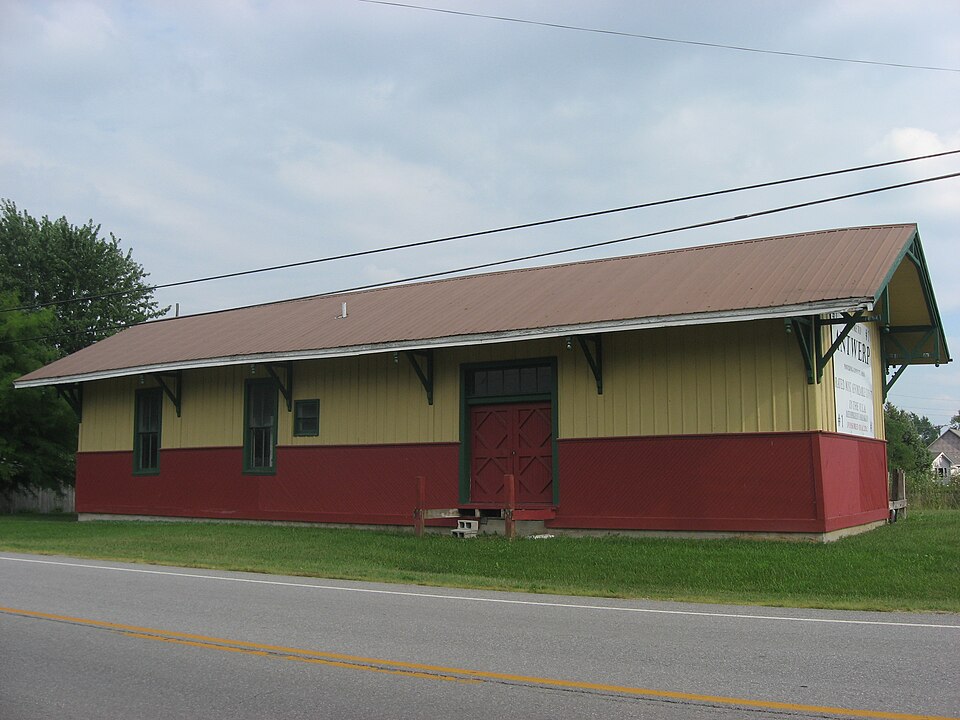
Photograph of Antwerp station
Photograph by Nyttend, Public domain. Via Wikimedia Commons.

Antwerp Norfolk and Western Depot

Built in 1880. Listed on the National Register of Historic Places in 1980. A historic map-sheet match is not published yet. The record needs a coordinate-quality review before it can be joined to a sheet boundary.

From the record

“Antwerp station is a historic former train station in the village of Antwerp in the far western portion of the U.S. state of Ohio. Louis and Pacific Railway, it is a primarily wooden structure with weatherboarded walls.”

Wikipedia article Antwerp station, CC BY-SA 4.0.

one of 3 National Register listings in Paulding County · listed in 1980 · category: Building · built in 1880, by Wabash Railroad.

Sources: the Wikipedia article · the case file at the National Archives · the National Register database, National Park Service

The listing

  • What is counted as historic. The nomination lists 1 building as contributing to the listing.
  • Address. W. Water St., Antwerp, 45813
  • When was it listed? 1980-09-23
  • Category. building
  • Township. Carryall township
  • When was it built? 1880
  • Architect. Wabash Railroad
  • National Register reference number. 80003205 - the number the National Park Service assigned this property when it was listed, and the key its nomination file is catalogued under at the National Archives.

Specimens collected near this property

12 of 1,202 shown

Regional context, not property-specific evidence. Museums hold 1,202 specimens collected within 10 miles of Antwerp Norfolk and Western Depot between 1888 and 1973: 1,202 Animalia. 12 distinct Species records are shown. Collected by Adler, K. K., C L CLARK FROM HOMER PRICE, CLARENCE CLARK and others. Each is a physical object with a catalogue number, and each entry opens the museum's record. This is what was collected and kept, not a survey of what lives here - nothing can be concluded from a species being absent.

Image SpeciesYear Collected by Where, as recorded
Specimen of Epitheca cynosura (Say, 1840)Epitheca cynosura (Say, 1840)1943H. PricePaulding Township, Baily gravel pit
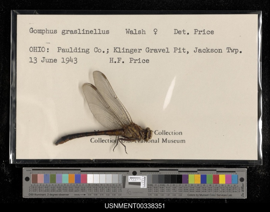
Specimen of Gomphus graslinellus Walsh, 1862Gomphus graslinellus Walsh, 18621943H. PriceKlinger Gravel Pit, Jackson Township
A photograph of the species Ammocrypta pellucida, not of this specimenAmmocrypta pellucida (Putnam, 1863)1888S. MeekMaumee River, Cecil, Ohio.
A photograph of the species Micropterus dolomieu, not of this specimenMicropterus dolomieu Lacepède, 18021888S. MeekMaumee River, Cecil, Ohio.
A photograph of the species Notropis spilopterus, not of this specimenNotropis spilopterus (Cope, 1867)1888S. MeekMaumee River, Cecil, Ohio.
A photograph of the species Notropis stramineus, not of this specimenNotropis stramineus (Cope, 1865)1888S. MeekMaumee River, Cecil, Ohio.
A photograph of the species Notropis ariommus, not of this specimenNotropis ariommus (Cope, 1867)1893Kirsch, P. (Philip)Maumee River, 2.5 mi above Antwerp, ~3.2 mi W of Antwerp, Carryall township
A photograph of the species Tyrannus tyrannus, not of this specimenTyrannus tyrannus (Linnaeus, 1758)1909Collector(s): Harold H. BaileyPayne
A photograph of the species Porzana carolina, not of this specimenPorzana carolina (Linnaeus, 1758)1910Price, H. (Homer)Paulding, Ohio, USA
A photograph of the species Sturnella magna, not of this specimenSturnella magna (Linnaeus, 1758)1912Price, H. (Homer)Paulding, Ohio, USA
A photograph of the species Geothlypis trichas, not of this specimenGeothlypis trichas (Linnaeus, 1766)1915Price, H. (Homer)Payne, Paulding Co., Ohio
A photograph of the species Passerherbulus henslowii, not of this specimenPasserherbulus henslowii (Audubon, 1829)1915Price, H. (Homer)Payne, Paulding Co., Ohio

All 1,202 specimens within 10 miles, at the Global Biodiversity Information Facility.

Storms near this property

38 since 1994

Regional context, not property-specific evidence. The National Weather Service names Antwerp, the town this property stands in, in 38 storm reports between 1994 and 2024: 21 thunderstorm wind, 14 hail, 2 flash flood, 1 flood. No death or injury is recorded in these reports. Each account below is quoted exactly as the forecast office filed it, from the NOAA Storm Events Database, and each date opens the federal record of that event.

WhenEvent Place namedHarm What the report says
November 2005Thunderstorm WindAntwerp$100,000Numeorus trees were blown down, including several two foot diameter oak trees and a 25 foot pine tree. Structure damage was also reported in Antwerp as well as northeast of Paulding. Damage is estimated around $100,000. Surveys from local emergency and NWS officials found evidence of the formation of gustnadoes where concentrated areas of damage were observed.
July 2024Thunderstorm WindAntwerp$25,000Photo on Facebook of a large tree down onto a house near the intersection of US 24 and Road 21.
March 2006Thunderstorm WindAntwerp$10,000Utility poles were blown down near the intersection of county roads 192 and 49. A chimney was blown down near the intersection of county roads 53 and 220.
June 1998Thunderstorm WindAntwerp$10,000MANY TREES BLOWN DOWN INCLUDING ONE 2 FEET IN DIAMETER
March 1998Thunderstorm WindAntwerp$3,000Several trees downed.
October 1996Thunderstorm WindAntwerp$3,000no account filed
August 2022Thunderstorm WindAntwerp$2,000Three to six inch diameter tree limbs were down across the down.
September 2019Thunderstorm WindAntwerp-A trained spotter reported a few power poles were leaning on State Route 49, north of Payne.
April 2017HailAntwerp-Emergency management officials reported two inch diameter hail, which caused some window and siding damage.
August 2015Thunderstorm WindAntwerp-Emergency management officials reported large tree limbs were blown onto the top of two homes.
June 2015FloodAntwerp-While overall rainfall amounts were not as widespread as other adjacent counties, what rain did fall only added to rising river and creek levels from upstream rainfall. Numerous township, county and state roads were impacted by high water, forcing high water signage or in some cases closures. No rescues or property damage was reported. Damage estimates for any roads was not available.
July 2015Thunderstorm WindAntwerp-Five power poles snapped.
July 2014Thunderstorm WindAntwerp-Estimated 70 mph wind gusts were reported in the area.
June 2012Thunderstorm WindAntwerp-A trained spotter reported widespread large trees down.
June 2012Thunderstorm WindAntwerp-A mesonet site recorded a 76 mph wind gust.
June 2012Thunderstorm WindAntwerp-A mesonet site on U.S. 24, near the Indiana/Ohio state line measured a 76 mph wind gust.
July 2011Thunderstorm WindAntwerp-Emergency management officials reported a tree fell onto a house at the intersection of River and Madison Streets. Numerous other trees and tree limbs were reported down in and around Antwerp.
August 2011HailAntwerp-Trained spotter reported dime size hail at Ohio 49 and County Road 111.
May 2011Flash FloodAntwerp-Emergency management officials reported to the local newspaper that County Road 204, between County Road 7 and the state line were closed due to high water. Several other roads in the extreme northwestern part of the county were also seeing three to 6 inches of water flowing across them as ditches began to overflow.
May 2010Flash FloodAntwerp-Emergency management officials reported numerous roads impassable in the extreme northwestern portion. This included State-Line and County-Line Roads, as well as other county roads near the town of Antwerp.
June 2010Thunderstorm WindAntwerp-Small tree down.
June 2004Thunderstorm WindAntwerp-Law enforcement reported power lines down in Antwerp.
June 2004Thunderstorm WindAntwerp-Emergency management reported numerous trees down in Antwerp.
June 2003Thunderstorm WindAntwerp-Law enforcement reported trees down near Antwerp.
September 2001Thunderstorm WindAntwerp-Power lines blown down.
May 2000Thunderstorm WindAntwerp-Large tree limbs down.
June 2019HailAntwerp-no account filed
May 2011HailAntwerp-no account filed
April 2011HailAntwerp-no account filed
May 2007HailAntwerp-no account filed
June 2006HailAntwerp-no account filed
May 2006HailAntwerp-no account filed
July 2005HailAntwerp-no account filed
September 2005HailAntwerp-no account filed
June 2004HailAntwerp-no account filed
June 1994HailAntwerp-no account filed

Every storm recorded in Paulding County

Map coverage status

No historic map-sheet match is published for this property yet. That does not mean no map exists. This record needs a coordinate-quality review before it can be joined to a sheet boundary. Browse the county's mapped places while that work is pending.

From the nomination file

7,292 words on record

When this property was proposed for the National Register, someone wrote the case for it: what the building is, and why it matters. That document is a federal record in the public domain. It is quoted below word for word, never summarised. The text was read off the scanned case file by machine, so the occasional stray character is the recogniser's and the 1970s typewriter's.

Description of the property

.deteriorated The mast of the station order board still stands, but the arms are now the term "high balling" was derived. The name of the town ANIWERP is painted on the - good gone. ruins unexposed Check one and knobs at the eaves line decorate its exterior.The handsome three sided bay area the east.Historic photos from around 19oo indicate that at one time the spaces were 8.

Statement of significance

(in one paragraph) the station on the west edge of town in a park along the railroad tracks. Specific dates circa 1880 X_1800-1899 - archeology-prehistoric - _ community planning _ religion The depot was moved in December 1979 the Norfolk and Western Railroad were unsuccessful in obtaining any commitment for its interested in obtaining an emergency grant for roof restoration. landscape architecture forcing the local historical society into action.T trim and large size indicate that this town of Antwerp was the metropolis of the 9.

The whole case file for this property - 7,292 words, 46 pages, reproduced complete.

Quoted from the National Register nomination for reference 80003205, 46 pages, held by the National Archives in Record Group 79. See the catalogue record.

Sources for this property

National Archives recordThe nomination case file for reference 80003205 in Record Group 79.
Wikipedia articleCommunity-written account of this property, licensed CC BY-SA.
Paulding CountyAll 3 listed properties in this county.

Provenance

  • Listing record. National Park Service National Register of Historic Places, listed-properties dataset, current to 2026-05-22.
  • Map join. Address geocoded through the United States Census geocoder, then tested against the published boundary of every sheet in the USGS Historical Topographic Map Collection.
  • How this page is made. Listing fields come from federal records; map-sheet coverage is a labelled coordinate-to-boundary calculation, not a source-field claim.
  • Specimens. Global Biodiversity Information Facility (GBIF), https://www.gbif.org/. Only records licensed CC0 or CC BY are used. Records licensed CC BY-NC are excluded because this site carries advertising. Images are checked individually and any whose licence is non-commercial, no-derivatives or unreadable is refused.
  • Storms. NOAA National Centers for Environmental Information, Storm Events Database https://www.ncei.noaa.gov/stormevents/ A work of the United States government, no copyright under 17 U.S.C. 105. Narratives are quoted verbatim from the National Weather Service report and are not edited or summarised.