Listed on the National Register of Historic Places in
1981. A historic map-sheet match is not published yet. The record needs a coordinate-quality review before it can be joined to a sheet boundary.
From the record
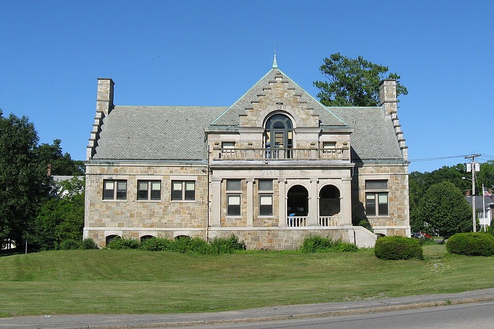
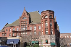
“The Fogg Library is a historic library building at 1 Columbian Street in Weymouth, Massachusetts. Built in 1897 to a design by Cutting, Carleton & Cutting, the Renaissance Revival stone building serves as a branch of the Weymouth Public Library.”
Wikipedia article Fogg Library, CC BY-SA 4.0.
one of 249 National Register listings in Norfolk County · listed in 1981 · category: Building · one of 2 National Historic Landmarks in Norfolk County.
National Register reference number.81000113- the number the National Park Service assigned this property when it was listed, and the key its nomination file is catalogued under at the National Archives.
Fires near this property
376 since 2015
Regional context, not property-specific
evidence. The
federal wildfire occurrence database
lists 376 fires within 5 miles of Fogg Library between
2015 and 2020, burning about 168 acres in total. None started naturally. 1 was recorded as arson.
Distance is straight-line from the map coordinates, so a fire counted
here may appear on a neighbouring settlement's page as well.
Reported cause
Fires
Recreation and ceremony
129
Debris and open burning
120
Missing data/not specified/undetermined
75
Smoking
35
Misuse of fire by a minor
13
Fireworks
2
Arson/incendiarism
1
Equipment and vehicle use
1
The most recent of
them, most recent first, with the day each was reported and the service
that recorded it.
Regional context, not property-specific
evidence. Museums hold 4,398 specimens
collected within 10 miles of Fogg Library between 1832 and
1975: 2,129 Plantae, 1,448 Animalia, 754 Fungi, 27 Chromista, 22 Protozoa, 12 Unrecorded, 6 Bacteria. 12 distinct Species records are shown.
Collected by (MARSDEN, H W), A Loveridge, A W Cheever and others. Each is a
physical object with a catalogue
number, and each entry opens the museum's record. This is what was
collected and kept, not a survey of what lives here - nothing can be
concluded from a species being absent.
Regional context, not property-specific
evidence. The federal mineral resources record lists
20 workings within 5 miles of Fogg Library: 10 past producers, 10 producers.
10 still produce. What was taken out: Sand and Gravel, Construction, Granite, Stone, Crushed/Broken. Distance is straight-line from the
map coordinates, so a quarry counted here may appear on a neighbouring
settlement's page as well.
Regional context, not property-specific
evidence. The National Weather Service names
Weymouth, the town this property stands in, in 22 storm reports between 1997 and 2025: 7 thunderstorm wind, 5 flash flood, 3 hail, 3 lightning.
No death or injury is recorded in these reports. Each account below is quoted exactly as the forecast office
filed it, from the NOAA Storm Events Database, and each date
opens the federal record of that event.
Minor flooding occurred along the Old Swamp River in South Weymouth, as a result of nearly 4 inches of rainfall in an 18-hour period. A crest of 4.6 feet was observed around 11 am EST on the 24th, which was just over its flood stage of 4.5 feet. No flood damage was reported.
No historic map-sheet match is published
for this property yet. That does not mean no map exists. This record needs
a coordinate-quality review before it can be joined to a sheet boundary.
Browse the county's mapped places while that work is
pending.
From the nomination file
1,904 words on record
When this property was proposed for the
National Register, someone wrote the case for it: what the building is,
and why it matters. That document is a federal record in the public domain.
It is quoted below word for word, never summarised. The text was read off the scanned case file by machine, so the
occasional stray character is the recogniser's and the 1970s
typewriter's.
Description of the property
The Fogg Library (1897-1898) is an excellent example of late Victorian eclecticism in Weymouth. The building combines Dutch and classical elements in an unusual but dignified composition. Fogg Library is impressively sited on a generous lot over- looking Columbian Square, a major traffic intersection. The architects of the Fogg Library were the well-known firm of Cutting, Carlton, and Cutting of Worcester. The style of architecture, while not strictly pure, approaches the Italian Renaissance. Dutch motifs may have been influenced by the "Dutch House," Holland's pavilion at the 1893 Chicago World's Fair, which was re- constructed in Brookline in 1894. The 1½ story building is composed of a small central block with a hip roof and two asymmetrical, gabled wings.
The exterior is built of random coursed ashlar with a granite water table and limestone cornices, quoins, pilasters, copings, window sills, and lintels. The roof is covered with green slate, and all the metal work of the roof, as skylights, crestings, and gutters, are of copper. The 1-story wings of the building feature step gables and slightly projecting end chimneys. The fenestration consists of paired rectangular windows on the facade and single windows on the other elevations, all with rectangular limestone sills and lintels. Windows on the east wing have stained glass transoms created by Redding, Baird, & Co. of Boston. The delicately colored Brisi glass reproduces the marks or trade devices of early printers and booksellers.
The walls are ornamented with a molded water table above the basement, a stringcourse above the first floor windows, a molded cornice on the wings, and a decorative entablature on the central block. The 1½ story central block is the most distinctive exterior feature of the build- ing, with its first floor loggia and second story gabled pavilion.
/Architect Cutting, Carlton, and Cutting (Worcest Statement of Significance (in one paragraph) The Fogg Library is an architectural and visual landmark of the village of South Weymouth and represents the philanthropy of one of the town's leading nineteenth- century industrialists. The building thus meets criteria B and C of the National Register of Historic Places. The Fogg Library is the third such association in South Weymouth. The establish- ment of this library and building was the result of the munificence of the late John S. Fogg, a prominent Weymouth banker and shoe manufacturer. Fogg (1817-1892) left in his will $50,000 to found and perpetuate "in that part of Weymouth known as South Weymouth" a free public library.
It was also his intention to provide a fine hall for public assemblies and a building that would be an ornament to the community and town. A few years ago, the Fogg Library gave up its charter as a private library and became a branch of the Town's library system. The site chosen for the Fogg Library Buildling is located in one of the most historically significant areas of the town, Columbian Square, and the architecture of the building is complemented by the location. The formality and severity of the composition are relieved by a curious combination of stylistic motifs, forming a reserved yet ambitious design. The step gables and classical loggia are partic- ularly distinguishing features of this civic landmark.
Quoted from the National Register nomination
for reference 81000113, 11 pages, held by the National Archives in Record
Group 79. See the
catalogue record.
Listed places nearby
6 within 8 miles
Other National Register properties close
enough to walk or drive between, ordered by distance from this one. Both
positions come from the same geocoding pass that matched these properties
to their map sheets.
Listing record. National Park Service National Register of Historic Places, listed-properties dataset, current to 2026-05-22.
Map join. Address geocoded through the United States Census geocoder, then tested against the published boundary of every sheet in the USGS Historical Topographic Map Collection.
How this page is made. Listing fields come from federal records; map-sheet coverage is a labelled coordinate-to-boundary calculation, not a source-field claim.
Wildfire. Short, Karen C. 2022. Spatial wildfire occurrence data for the United States, 1992-2020 [FPA_FOD_20221014]. 6th Edition. Fort Collins, CO: Forest Service Research Data Archive. https://doi.org/10.2737/RDS-2013-0009.6 Collected with United States Government funding and usable without additional permissions or fees.
Specimens. Global Biodiversity Information Facility (GBIF), https://www.gbif.org/. Only records licensed CC0 or CC BY are used. Records licensed CC BY-NC are excluded because this site carries advertising. Images are checked individually and any whose licence is non-commercial, no-derivatives or unreadable is refused.
Mines and quarries. USGS Mineral Resources Data System (MRDS) https://mrdata.usgs.gov/mrds/ A work of the United States government, no copyright under 17 U.S.C. 105.
Storms. NOAA National Centers for Environmental Information, Storm Events Database https://www.ncei.noaa.gov/stormevents/ A work of the United States government, no copyright under 17 U.S.C. 105. Narratives are quoted verbatim from the National Weather Service report and are not edited or summarised.
 Block
Block