Listed on the National Register of Historic Places in
1981. A historic map-sheet match is not published yet. The record needs a coordinate-quality review before it can be joined to a sheet boundary.
From the record
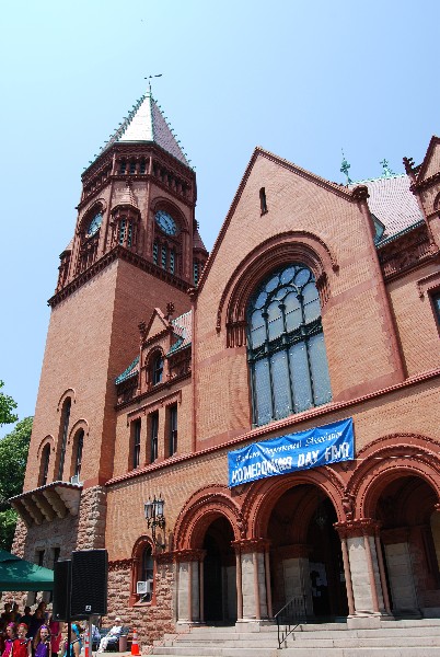
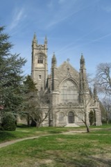
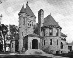
“Fairhaven Town Hall is the town hall of Fairhaven, Massachusetts. It is located at 40 Center Street, between Walnut and William Streets, across Center Street from the Millicent Library.”
Wikipedia article Fairhaven Town Hall, CC BY-SA 4.0.
one of 272 National Register listings in Bristol County · listed in 1981 · category: Building · one of 8 National Historic Landmarks in Bristol County.
National Register reference number.81000122- the number the National Park Service assigned this property when it was listed, and the key its nomination file is catalogued under at the National Archives.
Not unworthy of a name so suggestive is the pleasant town which lies at the southeastern corner of Bristol County. Originally a portion of the township of Dartmouth incorporated in 1664, it was included in a grant of lands from their Indian owners to the colonists dated Nov. 29, 1652. The eastern boundary of this grant was three miles eastward from the Acushnet River. The Indian name of the vicinity was Sconticut, an appellation now confined to the neck of land which stretches from the southeastern part of the town into the bay. In 1787 the town of New Bedford, including the present city of that name, together with the towns of Fairhaven and Acushnet, was incorporated. In 1812, when political feeling ran high, the Jeffersonian Democrats of Fairhaven, derisively called " Corsicans" by their opponents, the Federalists, on the opposite side of the river, on account of the attitude of the former towards Napoleonic affairs, effected a division of the township. In 1860 Fairhaven was in turn divided by the setting off of its northern portion as the town of Acushnet. As at present constituted, the town is apparently three miles square, exclusive of Sconticut Neck. From its northern limit at Acushnet it stretches along the river until it reaches its southwest corner at Fort Phomix, where the river broadens into an arm of the bay, forming the lower harbor of New Bedford and Fairhaven. This western water-line is broken by the marshes connecting the Isle of Marsh with the mainland, and by the peninsula on which is situated the village of Oxford. On the opposite bank of the river is the city of New Bedford. The southern shore-line, after extending nearly due east from Fort Phu?nix, is indented by a cove, and beyond this is broken by Sconticut Neck, which extends out into the bay. The eastern boundary is formed by the town of Mattaposett, in Plymouth County. The surface is generally level. Fort Phoenix stands on a rocky prominence overlooking the harbor and bay. This headland was called by the Indians Nolscot, and the ledge of which it forms a part extends up into the village, and crops out in Centre Street in front of the Congregational Church. A rocky bluff overlooks the river near the Acushnet boundary, and the land rises towards the northern and eastern sections of the town.
The village of Fairhaven is in the southwestern corner of the township, on the river, directly opposite New Bedford. Just north of the village, but with no dividing line between, is the little village of Oxford, generally known as the " Point." In the eastern part of the town are the hamlets of New Boston and Naskatucket. There is a considerable amount of wood and farming land, and along the southern boundary, at the head of the cove, an extent of salt marsh. Probably the village of Fairhaven grew up almost simultaneously with the village of Bedford, on the opposite side of the river, beginning near the middle of the last century. It remained, however, very small for a long period, for we find no record of the lay-out of a street until 1790, no church established until 1794, and the village remained confined to the wharves and a few short streets up to about the year 1832. The following-named persons, proprietors of lands granted by William Bradford, deputy governor of Plymouth Colony, in a deed dated Nov. 13, 1694, probably settled in this vicinity : Seth Pope, Thomas Taber, Jonathan Delano, Isaac Pope, Lettice Jenny, Samuel Jenny, Mark Jenny, Valentine Nuddlesene, Samuel Spooner, William Spooner, John Spooner, Joseph Tripp, Daniel Sherman, Edmund Sherman, John Davis. The first settlers probably scattered themselves over the limits of the town from Sconticut Neck to Acushnet, not uniting in villages for some years. There was a garrison on the bank of the river, just above the Isle of Marsh, in the old days of Indian warfare. The site of the ancient block-house, above theIsleofMarsh,ison landofMr. John M. Howland. Tradition relates that a man and woman by the name of Pope were murdered by the Indians in the locality of the Frog Pond while on their way to a fortified place of refuge. The Frog Pond occupied land which now borders the south side of Spring Street, between William and Walnut. Mr. Howland has gathered an interesting collection of relics from the ruins of the structure previously mentioned, consisting of household utensils, implements of Indian warfare, and among the rest an old key, supposed to be that belonging to the fortification, the name of which was Cook's Garrison. The old Cook house
Regional context, not property-specific
evidence. The
federal wildfire occurrence database
lists 28 fires within 5 miles of Fairhaven Town Hall between
2015 and 2020, burning about 16 acres in total. None started naturally. None was recorded as arson.
Distance is straight-line from the map coordinates, so a fire counted
here may appear on a neighbouring settlement's page as well.
Reported cause
Fires
Missing data/not specified/undetermined
11
Debris and open burning
9
Recreation and ceremony
3
Smoking
2
Fireworks
1
Power generation/transmission/distribution
1
Misuse of fire by a minor
1
The most recent of
them, most recent first, with the day each was reported and the service
that recorded it.
Regional context, not property-specific
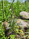
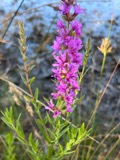
evidence. Museums hold 2,243 specimens
collected within 10 miles of Fairhaven Town Hall between 1824 and
1975: 928 Animalia, 632 Plantae, 568 Fungi, 87 Chromista, 23 Bacteria, 5 Unrecorded. 12 distinct Species records are shown.
Collected by A. B. Gridley, A. B. Seymour, A. Clark and others. Each is a
physical object with a catalogue
number, and each entry opens the museum's record. This is what was
collected and kept, not a survey of what lives here - nothing can be
concluded from a species being absent.
Regional context, not property-specific
evidence. The federal mineral resources record lists
2 workings within 5 miles of Fairhaven Town Hall: 1 unknown, 1 producer.
1 still produces. What was taken out: Stone, Crushed/Broken. Distance is straight-line from the
map coordinates, so a quarry counted here may appear on a neighbouring
settlement's page as well.
Regional context, not property-specific
evidence. The National Weather Service names
Fairhaven, the town this property stands in, in 30 storm reports between 1995 and 2024: 8 flood, 6 thunderstorm wind, 6 hail, 5 flash flood.
No death or injury is recorded in these reports. Each account below is quoted exactly as the forecast office
filed it, from the NOAA Storm Events Database, and each date
opens the federal record of that event.
Numerous streets were flooded including: Coggeshall and Dean Streets, Cove Road, West Rodney French Boulevard, and Brownell and Hawthorne Avenues in New Bedford. These roads were closed to traffic and emergency vehicles were rerouted around these streets to reach their destinations. At least one car was stuck in floodwaters with its occupants rescued. A fire truck got stuck in floodwaters on Route 18. Numerous basements were flooded. St. Luke's water temporarily stopped accepting patients due to flooding in the basement and cafeteria of the hospital, as well as around the hospital. In Dartmouth, significant flooding occurred on Russells Mills and Old Westport Roads. These roads were closed to traffic. Multiple cars were stuck in flood waters on Route 6E, which also ended up being closed.
Significant urban flash flooding affected New Bedford from thunderstorms with torrential rainfall. Belleville Avenue was flooded at Hatch Street making the road impassable. Route 6 on the New Bedford side of the New Bedford Fairhaven Bridge was flooded.
In New Bedford, numerous roads were flooded and impassable. These included: Route 18 by the railroad bridge; Purchase Street at Austin Street; Coggeshall Street at Route 18, where a car was stuck in the water.
In New Bedford, urban flash flooding occurred. At 521 PM EST, Sawyer Street was flooded. Then, at 530 PM EST, Summer Street was closed due to three feet of water on the road. Also, the Route 18 exit ramp to Purchase Street was flooded and impassable.
No historic map-sheet match is published
for this property yet. That does not mean no map exists. This record needs
a coordinate-quality review before it can be joined to a sheet boundary.
Browse the county's mapped places while that work is
pending.
From the nomination file
5,296 words on record
When this property was proposed for the
National Register, someone wrote the case for it: what the building is,
and why it matters. That document is a federal record in the public domain.
It is quoted below word for word, never summarised. The text was read off the scanned case file by machine, so the
occasional stray character is the recogniser's and the 1970s
typewriter's.
Description of the property
The Fairhaven Town Hall faces south on Center Street in downtown Fairhaven. It was design- ed by Charles Brigham and constructed between 1892 and 1894, and is in form and detail, and in structural and decorative materials, a product of the historically inspired architec- tural eclecticism of the late 19th century. As such the building displays many elements of both the Romanesque and the Gothic stylistic traditions without being a pure example of either style. The consistant use of round arched openings in conjunction with groups of narrow rectangular windows is late Victorian Romanesque in provenance . So also is the way in which the tower cape meet the walls below with cornices unbroken by secondary pinnacles, tabernacles, or pseudo-gables.
The absence of any jerkin-headed gables, poly- chrome banding or pointed or sequential arches strengthens an overall impression of Romanesque Revival. Nonetheless, many of the building's details are predominantly Gothic in inspiration. These include the crocketed turret caps that terminate in finials and the crested roof ridge which, though they have late Romanesque precedents, are actually Gothic characteristics and give the building a delicacy that is quite un-Romanesque. Also Gothic in origin are the great windows in the south, east and west gable fields which are mullioned into tall arches with trefoil shapes filling the window heads.
Certain of the picturesque compositional ele- ments that characterize the Town Hällalso look both to the Romanesque and to the Gothic Revivals for their origin. An example is the irregular roofline created by the polygonal cor- ner towners, one much taller and larger than the other; and by gable-ended wall dormers that break forward from the roofline and even from the facade plane. The Town Hall is nearly square in overall plan, 99' wide and 108' deep, with a basically pyramidal roof.
/Architect Statement of Significance (in one paragraph) The Fairhaven Town Hall possesses integrity of location, design, setting and materials and important associations as the center of Fairhaven social and municipal life for more than three quarters of a century. It is a major work of an important late 19th century architect, Charles Brigham; and it is one of a group of important buildings designed between 1890 and 1905 by Brigham and given to the citizens of Fairhaven by the oil mag- nate, Henry Huttleston Rogers. (The Town Hall was officially given to the town by Roger's wife, Abbie Palmer Gifford.) Because of this cluster of Rogers' gift buldings, Fairhaven is an important locus for any study of Charles Brigham's work.
Except for a short lived structure in a northern district known as Oxford Village, the building was Fairhaven's first town hall. Incorporated in 1812, the town held its early general meetings in a Methodist church at the head of the river in today's Acushnet. Sharp rivalry between the separate communities that comprised the town of Fairhaven led to disputes over the location of the seat of local governnent. In 1843 a town house was built in the Oxford section, but a fire in 1858 destroyed the building. After this, the meetings were held in Fairhaven village, in Sawin Hall, and Phoenix Hall, until the present structure was completed in 1894.
Several years before the announcement of the Rogers gift, Fairhaven citizens did vote $15000 for the construction of a town hall, an act which indicated that the need for such a building was recognized, but hardly afforded enough capital to undertake the con- struction of a building. The cornerstone of the Town Hall was laid with ceremony on May 30, 1892.
Quoted from the National Register nomination
for reference 81000122, 16 pages, held by the National Archives in Record
Group 79. See the
catalogue record.
Listed places nearby
6 within 8 miles
Other National Register properties close
enough to walk or drive between, ordered by distance from this one. Both
positions come from the same geocoding pass that matched these properties
to their map sheets.
Listing record. National Park Service National Register of Historic Places, listed-properties dataset, current to 2026-05-22.
Map join. Address geocoded through the United States Census geocoder, then tested against the published boundary of every sheet in the USGS Historical Topographic Map Collection.
How this page is made. Listing fields come from federal records; map-sheet coverage is a labelled coordinate-to-boundary calculation, not a source-field claim.
Wildfire. Short, Karen C. 2022. Spatial wildfire occurrence data for the United States, 1992-2020 [FPA_FOD_20221014]. 6th Edition. Fort Collins, CO: Forest Service Research Data Archive. https://doi.org/10.2737/RDS-2013-0009.6 Collected with United States Government funding and usable without additional permissions or fees.
Specimens. Global Biodiversity Information Facility (GBIF), https://www.gbif.org/. Only records licensed CC0 or CC BY are used. Records licensed CC BY-NC are excluded because this site carries advertising. Images are checked individually and any whose licence is non-commercial, no-derivatives or unreadable is refused.
Mines and quarries. USGS Mineral Resources Data System (MRDS) https://mrdata.usgs.gov/mrds/ A work of the United States government, no copyright under 17 U.S.C. 105.
Storms. NOAA National Centers for Environmental Information, Storm Events Database https://www.ncei.noaa.gov/stormevents/ A work of the United States government, no copyright under 17 U.S.C. 105. Narratives are quoted verbatim from the National Weather Service report and are not edited or summarised.
 Block
Block