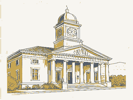
Listed on the National Register of Historic Places in
1981. A historic map-sheet match is not published yet. The record needs a coordinate-quality review before it can be joined to a sheet boundary.
From the record
one of 21 National Register listings in Wood County · listed in 1981 · category: Building · one of 1 National Historic Landmarks in Wood County.
National Register reference number.81000453- the number the National Park Service assigned this property when it was listed, and the key its nomination file is catalogued under at the National Archives.
Regional context, not property-specific
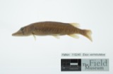
evidence. Museums hold 287 specimens
collected within 10 miles of North Baltimore Town Hall between 1929 and
1975: 283 Animalia, 2 Plantae, 2 Fungi. 12 distinct Species records are shown.
Collected by C. Triplehorn, Creamer, D., Daiber, F. C. (Frank C.) and others. Each is a
physical object with a catalogue
number, and each entry opens the museum's record. This is what was
collected and kept, not a survey of what lives here - nothing can be
concluded from a species being absent.
Regional context, not property-specific
evidence. The National Weather Service names
North Baltimore, the town this property stands in, in 17 storm reports between 1995 and 2023: 10 thunderstorm wind, 5 hail, 1 flash flood, 1 tornado.
No death or injury is recorded in these reports. Each account below is quoted exactly as the forecast office
filed it, from the NOAA Storm Events Database, and each date
opens the federal record of that event.
Numerous trees and power lines were reported down from North Baltimore east to the northwest side of Fostoria. Several power poles were snapped northwest of Fostoria, and a barn was damaged along State Route 199.
An EF1 tornado touched down northwest of North Baltimore along Quarry Road to the west of Liberty Hi Road. A home near the initial touchdown was partially destroyed when a portion of its roof tore off allowing a wall to collapse. The tornado continued on the ground for around a mile before lifting. Damage elsewhere along the damage path consisted of a few downed trees. The parent thunderstorm responsible for this tornado later produced another tornado near Jerry City.
Thunderstorm winds downed several large trees and many limbs. One of the trees struck a moving vehicle. The vehicle was severely damaged but the driver was not injured.
No historic map-sheet match is published
for this property yet. That does not mean no map exists. This record needs
a coordinate-quality review before it can be joined to a sheet boundary.
Browse the county's mapped places while that work is
pending.
Named in the fire insurance atlases
Sanborn surveyors printed an index of the
town's establishments at the front of each atlas. This property is named in
one, read straight off the scanned sheet.
When this property was proposed for the
National Register, someone wrote the case for it: what the building is,
and why it matters. That document is a federal record in the public domain.
It is quoted below word for word, never summarised. The text was read off the scanned case file by machine, so the
occasional stray character is the recogniser's and the 1970s
typewriter's.
Description of the property
department and prison cells on the ground floor, and the Mayor's and clerk's offices Presently the building houses the police department and offices for the EMS, an answering service and disaster services, as well as equipment storage for the EMS building is located on the north side, part of which is occupied by the Mayor and The overall shape of the town hall is rectangular. It was originally designed with The belfry still contains the old bell, which is in working condition. Fire siren equipment has been added to this tower. The building was constructed of firepressed brick(manufactured locally by the North The central section of the existing building is flanked by the two towers, one of CONDITION UNEXPOSED UNALTERED clerk offices and council chambers. CHECK ONE FAIR domed roof.
The central section of the building contains an open porch area at the second floor some phase of municipal government since it was constructed. floors are located throughout. Other decorative elements include pedimented cornices on each side of the belfry corbeling in the brick extends from this point to the tower roof.A stained glass level.A large stained glass window is located above the second story windows.
architectural features, particularly the belfry, hose tower and stained glass the finestand compares favorably with other town halls of its time period around the State of Ohio. The old Town Hall is the only building in the Village of North Baltimore, to date, to be nominated for inclusion in the National Register department, jail and Mayor and town clerk offices, it has housed some Village facing and metal molding of the newer village offices were merely attached to the 1890 1400-1499 1600-1699 1500-1599 1700-1799 ART ARCHEOLOGY-HISTORIC LAW PERIOD TRANSPORTATION 1900- SCIENCE PHILOSOPHY EDUCATION significant structure.
AGRICULTURE RELIGION SIGNIFICANCE _COMMUNICATIONS MILITARY INDUSTRY SCULPTURE LITERATURE Architect Unknown ARCHEOLOGY-PREHISTORIC _COMMERCE Village administration buildings on both sides),thus an identifiable relationship The building will retain some Village administration is bounded by The North Baltimore Town:Hall is significant in that it has many unusual and artistic _ENGINEERING priateness of this alteration and is developing plans for its removal in the future. historical integrity to retain the 1890's period.Inclusion of this structure -SOCIAL/HUMANITARIAN _CONSERVATION of Historic Places. BUILDER/ARCHITECT H.F. Hilgeneck Builder _THEATER The building was completed on January 1,1890 and was dedicated at a public -MUSIC windows.
In comparison to other old town halls in Wood County, this is one of ceremony on February 27, 1890. From that time, when it housed the fire enclosed letter from the mayor, the village administration recognizes the inappro- INVENTION in the National Register will serve to focus attention on this architecturally- The Town Hall fundamentally remains today as it was constructed in 1890.The brick with its history will be retained.The Village intends to restore the building's
Quoted from the National Register nomination
for reference 81000453, 21 pages, held by the National Archives in Record
Group 79. See the
catalogue record.
Listing record. National Park Service National Register of Historic Places, listed-properties dataset, current to 2026-05-22.
Map join. Address geocoded through the United States Census geocoder, then tested against the published boundary of every sheet in the USGS Historical Topographic Map Collection.
How this page is made. Listing fields come from federal records; map-sheet coverage is a labelled coordinate-to-boundary calculation, not a source-field claim.
Specimens. Global Biodiversity Information Facility (GBIF), https://www.gbif.org/. Only records licensed CC0 or CC BY are used. Records licensed CC BY-NC are excluded because this site carries advertising. Images are checked individually and any whose licence is non-commercial, no-derivatives or unreadable is refused.
Storms. NOAA National Centers for Environmental Information, Storm Events Database https://www.ncei.noaa.gov/stormevents/ A work of the United States government, no copyright under 17 U.S.C. 105. Narratives are quoted verbatim from the National Weather Service report and are not edited or summarised.
 Block
Block