Listed on the National Register of Historic Places in
1982. A historic map-sheet match is not published yet. The record needs a coordinate-quality review before it can be joined to a sheet boundary.
From the record
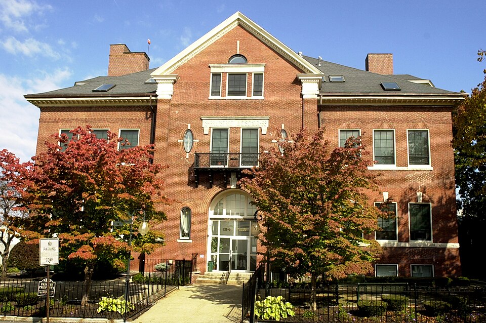
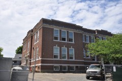
“Ronan School, originally the Bradstreet Avenue School, is a historic former school building at 154 Bradstreet Avenue in Revere, Massachusetts. The Classical Revival style brick building was built in 1896, during a period of rapid growth in the city's Beachmont neighborhood.”
Wikipedia article Mary T. Ronan School, CC BY-SA 4.0.
one of 206 National Register listings in Suffolk County · listed in 1982 · category: Building · one of 5 National Historic Landmarks in Suffolk County.
National Register reference number.82000485- the number the National Park Service assigned this property when it was listed, and the key its nomination file is catalogued under at the National Archives.
The Post-Oflfice of Revere (North Chelsea) was established July 'I'i, 184(i, the first Postmaster being; Joseph H. Fenno, who served a community of about 750 persons. He was succeeded l:)y William Fenno, Hatch Crocker, George Newcomb, and James L. Wiggin, the latter being the last of the independent Postmasters at Revere. June 1, 1875, Revere became a Boston vStation, and free delivery was introduced in a Town that covered (August 1, 1892) about 3,540 acres, with a population of about 1,750 on July 1, 1875, and U,000 in 1892.
Winthrop, set off from North Chelsea (Revere) in 1853, was named after Deane Winthrop. The Post-Office was established February 2, 1853, and has had but one chief, Warren Belcher having been Postmaster up to May :]1, 1875, and head of the Station since. His allowance in 1855 was $17.17; the surplus, $5.84; the community served, less than 500. The Census of 1870 reports the population of Winthrop at 532. It is now about 3,500 (August 1, 18'.t2), and the area, 980 acres. Winthrop has had free delivery since June 1, 1875, when it became a jjart of postal Boston. It had been a part of municipal Boston up to 173!).
Regional context, not property-specific
evidence. The
federal wildfire occurrence database
lists 29 fires within 5 miles of Ronan, Mary, T., School between
2003 and 2020, burning about 17 acres in total. None started naturally. 2 were recorded as arson.
Distance is straight-line from the map coordinates, so a fire counted
here may appear on a neighbouring settlement's page as well.
Reported cause
Fires
Missing data/not specified/undetermined
12
Debris and open burning
9
Smoking
4
Arson/incendiarism
2
Recreation and ceremony
2
The most recent of
them, most recent first, with the day each was reported and the service
that recorded it.
Regional context, not property-specific
evidence. Museums hold 14,821 specimens
collected within 10 miles of Ronan, Mary, T., School between 1810 and
1975: 7,221 Plantae, 3,224 Fungi, 2,650 Animalia, 1,258 Chromista, 223 Bacteria, 134 Protozoa, 111 Unrecorded. 12 distinct Species records are shown.
Collected by ?, A B Seymour, A C Gibson and others. Each is a
physical object with a catalogue
number, and each entry opens the museum's record. This is what was
collected and kept, not a survey of what lives here - nothing can be
concluded from a species being absent.
Regional context, not property-specific
evidence. The federal mineral resources record lists
10 workings within 5 miles of Ronan, Mary, T., School: 6 plants, 2 producers, 1 past producer, 1 unknown.
8 still produce. What was taken out: Stone, Crushed/Broken, Gypsum-Anhydrite, Iron, Lead. Distance is straight-line from the
map coordinates, so a quarry counted here may appear on a neighbouring
settlement's page as well.
Regional context, not property-specific
evidence. The National Weather Service names
Revere, the town this property stands in, in 26 storm reports between 1998 and 2023: 9 flood, 8 thunderstorm wind, 3 hail, 3 flash flood.
The reports record 1 death. Each account below is quoted exactly as the forecast office
filed it, from the NOAA Storm Events Database, and each date
opens the federal record of that event.
A roof was blown off a house on Winthrop Parkway in Revere. In addition, a tree, large limbs, and wires were downed by thunderstorm winds in Winthrop. The tree and branches were downed onto cars.
At 720 AM EST in Revere, a car was trapped in one foot of flooding on State Route 1A near the East Boston line. At 742 AM EST, amateur radio reported a flooded basement on Curtis Road. At 747 AM EST, three cars were reported trapped in flood waters on the Revere Beach Parkway.
In Revere, eighteen inches of water flooded Bell Circle. In Boston, the intersection of Columbia Road and Quincy Street flooded with one car stuck in the flood waters. Brookline Avenue was flooding near the Riverway. In West Roxbury, the VFW Parkway flooded near the high school.
No historic map-sheet match is published
for this property yet. That does not mean no map exists. This record needs
a coordinate-quality review before it can be joined to a sheet boundary.
Browse the county's mapped places while that work is
pending.
From the nomination file
2,013 words on record
When this property was proposed for the
National Register, someone wrote the case for it: what the building is,
and why it matters. That document is a federal record in the public domain.
It is quoted below word for word, never summarised. The text was read off the scanned case file by machine, so the
occasional stray character is the recogniser's and the 1970s
typewriter's.
Description of the property
The Mary T. Ronan School is a 2½ story brick building constructed in a Classical Revival style. The school occupies a half-acre lot in the Beachmont section of Revere, a dense hilltop neighborhood of houses dating from the turn of the century. The Ronan School was built in 1896 as a simple rectangular structure. A smaller T-shaped wing was added to the rear in 1914 and copies the original design. The main block is 2½ stories high plus basement. broken on the facade by a gabled pavilion and by polygonally-capped dormers on the side elevations. Three thin chimneys pierce the roofline. Several horizontal elements articulate the elevations of the Ronan School.
A granite foundation and granite stringcourse outline the basement level, while a brick stringcourse and bracketed wooden cornice cap the walls. Windows are often grauped in threes, a motif reinforced by continuous granite sills on the second story. All the windows have splayed lintels of gauged brick, and those on the first floor are further ornamented by granite keystones. The most striking design element of this building is its central frontispiece. Brick pilasters with plinths and Ionic capitals carved in granite support a gabled roof with dentillated cornice. This 3-story bay is entirely symmetrical. On the first floor, a round-arched doorway is flanked by narrow roundarched windows; a granite keystone ornaments the entrance arch.
On the second floor, oval windows with granite keystones flank a pair of rectangular windows which are joined by a continuous granite entablature, on which the original name and date of the school are inscribed (Bradstreet Avenue School,1896). A decorative iron balcony ispans the base. of these windows. In the gable field, a Palladian motif window features a granite sill, entablature, and keystone.
/Architect N/A Statement of Significance (in one paragraph) The Mary T. Ronan School retains integrity of design, materials, workmanship, setting, and location. The building is associated with the historical development of the Beachmont area of Revere and is a significant example of its architectural type and period; it meets criteria A and C of the National Register. The coastal highlands of Revere were increasingly developed as a summer resort from the mid-19th century on. Early in this period, Beachmont was occupied by tent-dwellers from the surrounding towns of Chelsea, Everett, and Malden during the hot season. By the late l9th century, however, more permanent residential subdivisions were platted.
The Boston Land Company had purchased most of the land here and chartered a narrow gauge railroad which connected Beachmont to Boston and Lynn in 1875. As an inducement to settlement, the Land Company offered to provide for five years a free pass to each property owner building a house worth $2,000.Aboom in both summer and year-round homes the Stick, Second Empire, and Queen Anne styles. B an ucen ame sfeyles. Fingle and mut t-fami ly hones buit in Prame chot houne miti eigile roeo an decae ia 5 two-room building which also housed the community's religious services. A new, wood pressures, however, soon demanded another schoolhouse. The Mary T. Ronan School was built in 1896 for $35,000.
This modern, eight-room brick building boasted an assembly hall on the top floor, electric lights, bells, and speaking tubes. Originally known as the Bradstreet Avenue School, the building has since been renamed for one of its early principals, Mary T. Ronan, who was named to the post in 1904.
Quoted from the National Register nomination
for reference 82000485, 9 pages, held by the National Archives in Record
Group 79. See the
catalogue record.
Listed places nearby
6 within 8 miles
Other National Register properties close
enough to walk or drive between, ordered by distance from this one. Both
positions come from the same geocoding pass that matched these properties
to their map sheets.
Listing record. National Park Service National Register of Historic Places, listed-properties dataset, current to 2026-05-22.
Map join. Address geocoded through the United States Census geocoder, then tested against the published boundary of every sheet in the USGS Historical Topographic Map Collection.
How this page is made. Listing fields come from federal records; map-sheet coverage is a labelled coordinate-to-boundary calculation, not a source-field claim.
Wildfire. Short, Karen C. 2022. Spatial wildfire occurrence data for the United States, 1992-2020 [FPA_FOD_20221014]. 6th Edition. Fort Collins, CO: Forest Service Research Data Archive. https://doi.org/10.2737/RDS-2013-0009.6 Collected with United States Government funding and usable without additional permissions or fees.
Specimens. Global Biodiversity Information Facility (GBIF), https://www.gbif.org/. Only records licensed CC0 or CC BY are used. Records licensed CC BY-NC are excluded because this site carries advertising. Images are checked individually and any whose licence is non-commercial, no-derivatives or unreadable is refused.
Mines and quarries. USGS Mineral Resources Data System (MRDS) https://mrdata.usgs.gov/mrds/ A work of the United States government, no copyright under 17 U.S.C. 105.
Storms. NOAA National Centers for Environmental Information, Storm Events Database https://www.ncei.noaa.gov/stormevents/ A work of the United States government, no copyright under 17 U.S.C. 105. Narratives are quoted verbatim from the National Weather Service report and are not edited or summarised.
 Block
Block