Listed on the National Register of Historic Places in
1982. A historic map-sheet match is not published yet. The record needs a coordinate-quality review before it can be joined to a sheet boundary.
From the record
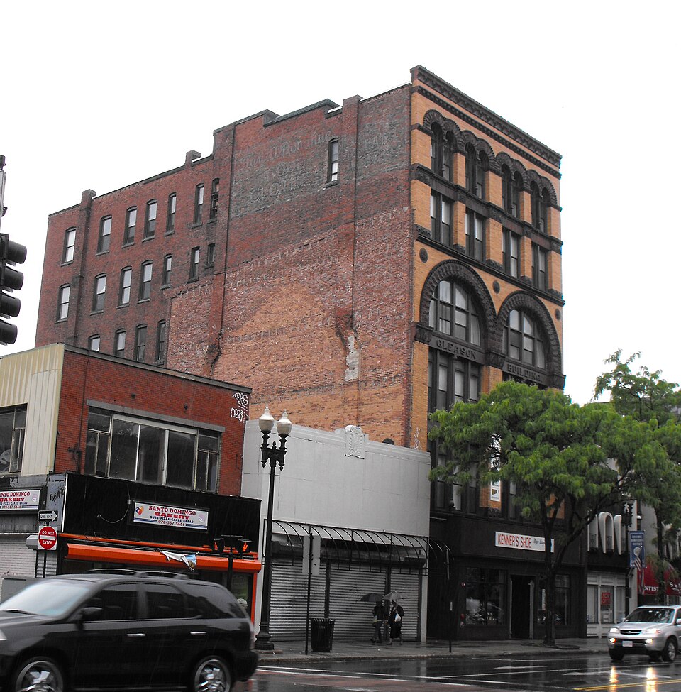
“The Gleason Building is a historic commercial building located at 349-351 Essex Street in Lawrence, Massachusetts.”
Wikipedia article Gleason Building (Lawrence, Massachusetts), CC BY-SA 4.0.
one of 350 National Register listings in Essex County · listed in 1982 · category: Building · one of 2 National Historic Landmarks in Essex County.
National Register reference number.82001880- the number the National Park Service assigned this property when it was listed, and the key its nomination file is catalogued under at the National Archives.
In the preparation of this work, I have endeavored to produce a liistorical reference book, giving a compact story of the founding of Lawrence and its development up to the present day. The table of contents has been laid out in a manner that should make it easy for the reader or student of local history to find information relative to any particular phase or period of the life of the community. I have been painstaking in my search for facts, and I am confident that what is printed will prove reliable.
In the research pertaining to the early history of Lawrence, valuable assistance was obtained by reference to Hayes' and Wads worth's histories, and also to the historical sketches by the late Hon. Robert H. Tewksbury. I am deeply indebted to Mrs. R. H. Tewksbury for her co-operation in permitting recourse to Mr. Tewksbury's last manuscript on Lawrence. Thereby, I have been enabled to clear up a number of inconsistencies that have appeared, besides securing some interesting facts in regard to the early days, which have not hitherto been printed.
Regional context, not property-specific
evidence. The
federal wildfire occurrence database
lists 83 fires within 5 miles of Gleason Building between
2002 and 2020, burning about 24 acres in total. 1 started naturally. 5 were recorded as arson.
Distance is straight-line from the map coordinates, so a fire counted
here may appear on a neighbouring settlement's page as well.
Reported cause
Fires
Missing data/not specified/undetermined
20
Smoking
19
Debris and open burning
9
Misuse of fire by a minor
8
Recreation and ceremony
7
Equipment and vehicle use
6
Arson/incendiarism
5
Railroad operations and maintenance
4
Power generation/transmission/distribution
4
Natural
1
The most recent of
them, most recent first, with the day each was reported and the service
that recorded it.
Regional context, not property-specific
evidence. Museums hold 1,242 specimens
collected within 10 miles of Gleason Building between 1816 and
1975: 694 Plantae, 409 Animalia, 121 Fungi, 5 Protozoa, 5 Bacteria, 4 Unrecorded, 4 Chromista. 12 distinct Species records are shown.
Collected by A Brown, A S Gaunt, A. C. Mathieson and others. Each is a
physical object with a catalogue
number, and each entry opens the museum's record. This is what was
collected and kept, not a survey of what lives here - nothing can be
concluded from a species being absent.
Regional context, not property-specific
evidence. The federal mineral resources record lists
7 workings within 5 miles of Gleason Building: 4 past producers, 1 unknown, 1 producer, 1 plant.
2 still produce. What was taken out: Sand and Gravel, Construction, Nickel, Gold, Silver, Copper, Perlite. Distance is straight-line from the
map coordinates, so a quarry counted here may appear on a neighbouring
settlement's page as well.
Regional context, not property-specific
evidence. The National Weather Service names
Lawrence, the town this property stands in, in 26 storm reports between 1998 and 2025: 7 flash flood, 7 thunderstorm wind, 7 flood, 3 hail.
No death or injury is recorded in these reports. Each account below is quoted exactly as the forecast office
filed it, from the NOAA Storm Events Database, and each date
opens the federal record of that event.
In Lawrence, trees were downed on Winthrop Avenue, Essex Street, Everett Street, and Methuen Street. A tree fell onto a house on Furber Street and another on Melvin Street. In North Andover, a large tree was downed on Boston Road near Route 114 and on Main Street. Damage was a little more extensive in Andover, where many trees were downed on the south side of town including on Vine Street. Trees and wires were downed on Bridle Path Road.
Trees and wires on South Union, Kent, Baily, and Dorchester Streets were downed by thunderstorm winds. A tree on Dorchester Street was downed onto a car.
At 455 PM EST, an amateur radio operator reported Chickering Road at State Route 114 in South Lawrence was flooded. A car nearby on Halsey Street was trapped in flood waters. At 524 PM EST a car was disabled in street flooding at Cutler Avenue and Chickering Road. Grafton Street was flooded and impassable.
Several streets were closed due to flooding. A car was stuck in floodwaters at the intersection of Andover Street and South Broadway near the Walgreens.
In Methuen, Lowell Street was impassable due to flash flooding. Two cars were trapped there. Broadway near Granite Street was flooded and impassable. Also, Route 110 near Bates Street was flooded and impassable. Jackson Street was also flooded and impassable.
In Lawrence, police reported street flooding on Andover Street between Clifron and Amherst Streets. The road was flooded and impassable. Report relayed by amateur radio.
In Lawrence, Berkeley Street was flooded and impassable from Sheridan Street to Jackson Street to East Haverhill Street. In addition, Parker Street was closed at the Merrimack River bridge due to flooding.
At 1124 AM EST, an amateur radio operator reported a car trapped in flood waters behind Partham Elementary School in Lawrence. The Automated Surface Observation System platform at Lawrence Airport recorded a storm total rainfall of 2.62 inches.
At 1045 AM EST, Parker Street in Lawrence was reported flooded and impassable between Merrimack and Market Streets. At 11 AM EST, the intersection of Salem Street and South Union Street was reported flooded and impassable. The Community Cooperative Rain Hail and Snow observer in Andover reported a storm total rainfall of 2.18 inches.
No historic map-sheet match is published
for this property yet. That does not mean no map exists. This record needs
a coordinate-quality review before it can be joined to a sheet boundary.
Browse the county's mapped places while that work is
pending.
From the nomination file
2,365 words on record
When this property was proposed for the
National Register, someone wrote the case for it: what the building is,
and why it matters. That document is a federal record in the public domain.
It is quoted below word for word, never summarised. The text was read off the scanned case file by machine, so the
occasional stray character is the recogniser's and the 1970s
typewriter's.
Description of the property
The Gleason Building is a six story brick commercial structure located in downtown Lawrence on the north side of Essex Street, the main commercial thoroughfare, on the block between Lawrence and Amesbury Streets. Constructed in 1890, the handsome Victorian Romanesque style Gleason Building was designed by Arthur F. Gray, a Lawrence architect whose work in the same city includes the Merchants Bank, now a part of the Downtown Lawrence National Register Historic District. The Gleason Building, rectangular in plan, has a frontage of 40 feet on Essex Street and extends 90 feet back to an alleyway. The property is butted on the east by a two story commercial structure and on the west by a one story commercial structure.
While the rear and side walls are of red brick, the Essex Street facade is of yellow brick trimmed with brownstone. The original appearance of the facade has not been altered except at the ground level. Originally the first floor front was flush with the upper stories. On the west side of the facade, an entrance led into the main hallway. The rest of the front was composed of two large display windows with a store entrance between them. Iron pilasters separated the hall entrance, the windows and the store entrance. An iron lintel above the ground floor set it apart from the upper floors. The position of the two entrances has not changed, but in recent years the display windows have been extended forward. New siding has been installed around the side entrance concealing the iron pilasters.
Most of the iron lintel has also been hidden by the new siding and by a large sign that extends above the store front. The composition of the unaltered upper 5 stories of the facade is symmetrical.
(in one paragraph) Builder/Architect Arthur F. Gray The Gleason Building possesses integrity of location, design, and materials, and as a major local example of Romanesque commercial architecture, meets criterion C. It is especially significant as one of the few important buildings outside of the Downtown Lawrence Historic District. The Gleason Building was constructed in 1890 by William Oswald, ore of the foremost dry goods merchants in the City. For years he operated the Boston Store at the corner of Essex and Appleton Streets and had branch stores in Lowell, Massachusetts and in Lewiston, Maine. Mr. Oswald was also the founder and director of the Merchants National Bank. At the time it was constructed, the six story Gleason Buidling stood as the largest of its kind in the city.
Above the store on the ground floor were forty-four rooms for offices. The top floor was built expressly as a photographer's studio, and had a large skylight to light the interior. The Gleason Building was also noteworthy at the time of its construction for boasting the first hydraulic elevator in the city. Other "modern improvements" included in the design were steam heat, electric lights and speaking tubes.
The Gleason Building was orginally praised not only for its innovative systems, but alio fon, thhe fase o the bunce of its be of a unique aid nof it sign, dition vastly from any building in the city"l and "The plans provide for a structure which will eclipse all others in the city and perhaps open a new era in the building history of Lawrence."2 The expanse of glass created by the bands of windows, and the bold Romanesque arches were features introduced with the Gleason Building and set it apart from other commercial structures on Essex Street.
Quoted from the National Register nomination
for reference 82001880, 13 pages, held by the National Archives in Record
Group 79. See the
catalogue record.
Listed places nearby
6 within 8 miles
Other National Register properties close
enough to walk or drive between, ordered by distance from this one. Both
positions come from the same geocoding pass that matched these properties
to their map sheets.
Listing record. National Park Service National Register of Historic Places, listed-properties dataset, current to 2026-05-22.
Map join. Address geocoded through the United States Census geocoder, then tested against the published boundary of every sheet in the USGS Historical Topographic Map Collection.
How this page is made. Listing fields come from federal records; map-sheet coverage is a labelled coordinate-to-boundary calculation, not a source-field claim.
Wildfire. Short, Karen C. 2022. Spatial wildfire occurrence data for the United States, 1992-2020 [FPA_FOD_20221014]. 6th Edition. Fort Collins, CO: Forest Service Research Data Archive. https://doi.org/10.2737/RDS-2013-0009.6 Collected with United States Government funding and usable without additional permissions or fees.
Specimens. Global Biodiversity Information Facility (GBIF), https://www.gbif.org/. Only records licensed CC0 or CC BY are used. Records licensed CC BY-NC are excluded because this site carries advertising. Images are checked individually and any whose licence is non-commercial, no-derivatives or unreadable is refused.
Mines and quarries. USGS Mineral Resources Data System (MRDS) https://mrdata.usgs.gov/mrds/ A work of the United States government, no copyright under 17 U.S.C. 105.
Storms. NOAA National Centers for Environmental Information, Storm Events Database https://www.ncei.noaa.gov/stormevents/ A work of the United States government, no copyright under 17 U.S.C. 105. Narratives are quoted verbatim from the National Weather Service report and are not edited or summarised.
 Block
Block