Listed on the National Register of Historic Places in
1982. A historic map-sheet match is not published yet. The record needs a coordinate-quality review before it can be joined to a sheet boundary.
From the record
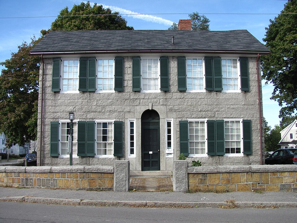
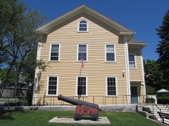
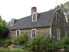
“The Sewall-Scripture House, is a historic house museum in Rockport, Massachusetts that is owned by the Sandy Bay Historical Society. The Sewall Scripture Museum features antiques, period artifacts and items of local history.”
Wikipedia article Sewall-Scripture House, CC BY-SA 4.0.
one of 350 National Register listings in Essex County · listed in 1982 · category: Building · one of 2 National Historic Landmarks in Essex County.
National Register reference number.82001902- the number the National Park Service assigned this property when it was listed, and the key its nomination file is catalogued under at the National Archives.
JOHN POOL was the second permanent settler of Rockport, finding upon his arrival there in the autumn of 1699, only the family of Richard Tarr, living in a log cabin. During the winter he took up a temporary residence in a small, vacant house, and in April of the following year purchased "a certain farme messuage" at a place commonly called "ye Cape," for one hundred and sixty pounds. Here he erected the first frame house of Rockport and settled with his family.
JOHN POOL, born in Taunton, Somerset, England, about 1670; died in Rockport, Massachusetts, May 19, 1727. He came to this country about 1690, or a little before, and married, first, Sarah Woodbury, nee Haskell, widow of Richard Woodbury and daughter of Roger Haskell. She died November 13, 1716, aged about 55.
Regional context, not property-specific
evidence. The
federal wildfire occurrence database
lists 18 fires within 5 miles of Sewall-Scripture House between
2016 and 2020, burning about 12 acres in total. None started naturally. 3 were recorded as arson.
Distance is straight-line from the map coordinates, so a fire counted
here may appear on a neighbouring settlement's page as well.
Reported cause
Fires
Recreation and ceremony
8
Arson/incendiarism
3
Misuse of fire by a minor
2
Debris and open burning
2
Smoking
2
Equipment and vehicle use
1
The most recent of
them, most recent first, with the day each was reported and the service
that recorded it.
Regional context, not property-specific
evidence. Museums hold 3,882 specimens
collected within 10 miles of Sewall-Scripture House between 1817 and
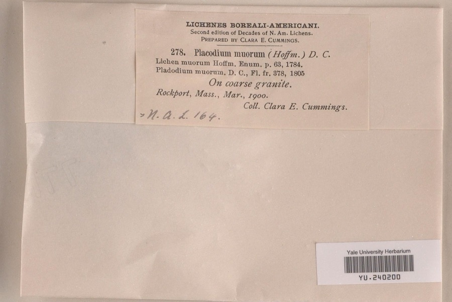
1975: 1,404 Animalia, 1,251 Plantae, 754 Fungi, 315 Chromista, 88 Protozoa, 50 Unrecorded, 20 Bacteria. 12 distinct Species records are shown.
Collected by A Perlmutter, A. A. Eaton, A. B. Seymour and others. Each is a
physical object with a catalogue
number, and each entry opens the museum's record. This is what was
collected and kept, not a survey of what lives here - nothing can be
concluded from a species being absent.
Regional context, not property-specific
evidence. The federal mineral resources record lists
8 workings within 5 miles of Sewall-Scripture House: 8 past producers.
None of them still produces. What was taken out: Granite, Sand and Gravel, Construction. Distance is straight-line from the
map coordinates, so a quarry counted here may appear on a neighbouring
settlement's page as well.
Regional context, not property-specific
evidence. The National Weather Service names
Rockport, the town this property stands in, in 2 storm reports between 2000 and 2000: 1 waterspout, 1 funnel cloud.
No death or injury is recorded in these reports. Each account below is quoted exactly as the forecast office
filed it, from the NOAA Storm Events Database, and each date
opens the federal record of that event.
No historic map-sheet match is published
for this property yet. That does not mean no map exists. This record needs
a coordinate-quality review before it can be joined to a sheet boundary.
Browse the county's mapped places while that work is
pending.
From the nomination file
2,138 words on record
When this property was proposed for the
National Register, someone wrote the case for it: what the building is,
and why it matters. That document is a federal record in the public domain.
It is quoted below word for word, never summarised. The text was read off the scanned case file by machine, so the
occasional stray character is the recogniser's and the 1970s
typewriter's.
Description of the property
The Sewall-Scripture House stands on a half-acre lot at the corner of King and Granite Streets, on the edge of central Rockport. The Federal-Style structure is included in a small scale residential neighborhood which developed gradually over the 18th and 19th centuries. Iwo and a half stories high with a gable roof, the most striking feature of the Sewall-Scripture House is its granite construction -- formed of dressed ashlar pieces measuring approximately one foot high by four to six feet in length. The rear wall is formed of large, coursed and square rubble. The Sewall-Scripture House is five bays long with a center entrance. The structure is only one room deep, although living space is increased by an original ell at the rear.
This gabled ell is 25 stories high, of frame construction with clapboard siding; it contains two rooms on each floor and is sheltered on its western side by a one-story porch with four Tuscan columns. block, and another, interior chimney serves both the main block and ell. Windows on the Sewall-Scripture House contain 9 over 6 sash. The House's primary (and most unusual) decorative feature is its tali doorway, composea of plain granite jambs and a narrow, stilted round arch (with keystone), flanked by sidelights. Between the arch and the rectangular door is a louvered fan. Interior woodwork is typically restrained, balancing the simplicity of the exterior design.
The Sewall-Scripture House contains a circular stairway in its central hall, wood shutters which fold into splayed window reveals, wainscoting, cornice moldings, and period chimneypieces. TX0020ON J99 9834 1O.aTCd noca 30.1 8.
Statement of significance
/Architect N/A Statement of Significance (in one paragraph) The Sewall-Scripture House retains integrity of design, materials, work- manship, location, and setting. It is significant for its association with Rockport's granite industry and as one of the few houses in town built of local granite. The property meets criteria A and C of the National Register. Levi Sewall, a native of Maine, built the Sewall-Scripture House in 1832 on the occasion of his marriage to Mary Ann Robards. The granite building blocks were hauled by oxen from Sewall's own quarry in Pigeon Cove, which is said to have produced stone of excellent quality.
Sewall was one of the towns earliest entrepreneurs in the granite business, first partner in Preston, Fernald & Co., and subsequently as founder of The Pigeon Hill Granite Company. The latter company flourished through the 19th and early 20th centuries with the help of his sons-in-law, Frank Scripture and George Bradford, until its merger in 1921 with the Rockport Granite Company. Rockport's granite industry commenced in 1824, when a Quincy businessman began large-scale quarrying and exporting here. By 1850, quarrying surpassed fishing as the town's leading business and in the late 19th century, employed as many as 700 men. Cut granite from Rockport was widely used throughout the country for paving blocks, public buildings, navy yards, and lighthouses.
Granite was unusual as a building material in Rockport, however, and occurs mainly in structures built for industrial use. Although Rockport possesses a remarkable collection of 18th and 19th century structures, the Sewall-Scripture House stands out as a fine example of the Federal style, delicately handled in stone. The area around the Sewall-Scripture House at King Street and Railroad Avenue is historically known as Sewall's Corner.
Quoted from the National Register nomination
for reference 82001902, 12 pages, held by the National Archives in Record
Group 79. See the
catalogue record.
Listed places nearby
6 within 8 miles
Other National Register properties close
enough to walk or drive between, ordered by distance from this one. Both
positions come from the same geocoding pass that matched these properties
to their map sheets.
Listing record. National Park Service National Register of Historic Places, listed-properties dataset, current to 2026-05-22.
Map join. Address geocoded through the United States Census geocoder, then tested against the published boundary of every sheet in the USGS Historical Topographic Map Collection.
How this page is made. Listing fields come from federal records; map-sheet coverage is a labelled coordinate-to-boundary calculation, not a source-field claim.
Wildfire. Short, Karen C. 2022. Spatial wildfire occurrence data for the United States, 1992-2020 [FPA_FOD_20221014]. 6th Edition. Fort Collins, CO: Forest Service Research Data Archive. https://doi.org/10.2737/RDS-2013-0009.6 Collected with United States Government funding and usable without additional permissions or fees.
Specimens. Global Biodiversity Information Facility (GBIF), https://www.gbif.org/. Only records licensed CC0 or CC BY are used. Records licensed CC BY-NC are excluded because this site carries advertising. Images are checked individually and any whose licence is non-commercial, no-derivatives or unreadable is refused.
Mines and quarries. USGS Mineral Resources Data System (MRDS) https://mrdata.usgs.gov/mrds/ A work of the United States government, no copyright under 17 U.S.C. 105.
Storms. NOAA National Centers for Environmental Information, Storm Events Database https://www.ncei.noaa.gov/stormevents/ A work of the United States government, no copyright under 17 U.S.C. 105. Narratives are quoted verbatim from the National Weather Service report and are not edited or summarised.
 Block
Block