Built in 1777 in the Federal architecture. Listed on the National Register of Historic Places in
1982. A historic map-sheet match is not published yet. The record needs a coordinate-quality review before it can be joined to a sheet boundary.
From the record
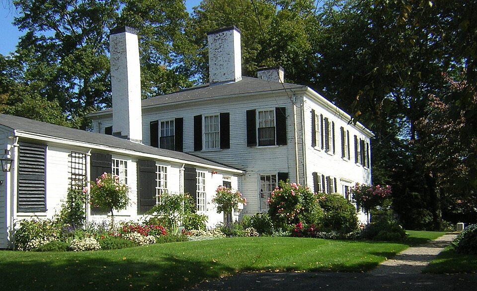
“The Belcher-Rowe House is a historic house at 26 Governor Belcher Lane in Milton, Massachusetts. Built in 1776-1777 by the widow and daughter-in-law of former colonial governor Jonathan Belcher, it is Milton's first known example of Federal style residential architecture.”
Wikipedia article Belcher-Rowe House, CC BY-SA 4.0.
one of 249 National Register listings in Norfolk County · listed in 1982 · category: Building · built in 1777, Federal architecture · one of 2 National Historic Landmarks in Norfolk County.
Architectural style. Federal architecture, Georgian architecture
National Register reference number.82002748- the number the National Park Service assigned this property when it was listed, and the key its nomination file is catalogued under at the National Archives.
Mr. Hunt was born in Scott's Woods, Milton. He is remembered with great affection as connected with the Sabbath School of the First Evangelical Church in his boyhood. The pastor of this church has followed him with the watchful interest of a sincere friend in his education and progress onward to the place he now occupies.
Since the above date a handsome church edifice has been erected on the Dorchester side, where the shepherd gathers his Milton and Dorchester flock. May the prophetic words come to pass : " There shall they lie in a good fold, and in a fat pasture shall they feed." - Ezekicl xxxiv. 14.
Regional context, not property-specific
evidence. The
federal wildfire occurrence database
lists 207 fires within 5 miles of Belcher-Rowe House between
2015 and 2020, burning about 119 acres in total. None started naturally. None was recorded as arson.
Distance is straight-line from the map coordinates, so a fire counted
here may appear on a neighbouring settlement's page as well.
Reported cause
Fires
Recreation and ceremony
150
Smoking
34
Missing data/not specified/undetermined
18
Debris and open burning
3
Equipment and vehicle use
2
The most recent of
them, most recent first, with the day each was reported and the service
that recorded it.
Regional context, not property-specific
evidence. Museums hold 12,899 specimens
collected within 10 miles of Belcher-Rowe House between 1810 and
1975: 5,580 Plantae, 3,605 Fungi, 3,023 Animalia, 394 Chromista, 204 Protozoa, 61 Unrecorded, 32 Bacteria. 12 distinct Species records are shown.
Collected by (MARSDEN, H W), ?, ? ex Herb. W.G. Farlow and others. Each is a
physical object with a catalogue
number, and each entry opens the museum's record. This is what was
collected and kept, not a survey of what lives here - nothing can be
concluded from a species being absent.
Regional context, not property-specific
evidence. The federal mineral resources record lists
3 workings within 5 miles of Belcher-Rowe House: 2 producers, 1 past producer.
2 still produce. What was taken out: Granite, Stone, Crushed/Broken, Sand and Gravel, Construction. Distance is straight-line from the
map coordinates, so a quarry counted here may appear on a neighbouring
settlement's page as well.
Regional context, not property-specific
evidence. The National Weather Service names
Milton, the town this property stands in, in 21 storm reports between 1996 and 2025: 9 thunderstorm wind, 5 lightning, 4 heavy rain, 1 hail.
The reports record 3 injuries. Each account below is quoted exactly as the forecast office
filed it, from the NOAA Storm Events Database, and each date
opens the federal record of that event.
Lightning struck a house on Augusta Road, causing a fire that engulfed the entire third floor of the house. No one was home at the time of the fire. Three firefighters were hospitalized for heat exhaustion but were released less than 24 hours later.
No historic map-sheet match is published
for this property yet. That does not mean no map exists. This record needs
a coordinate-quality review before it can be joined to a sheet boundary.
Browse the county's mapped places while that work is
pending.
From the nomination file
3,050 words on record
When this property was proposed for the
National Register, someone wrote the case for it: what the building is,
and why it matters. That document is a federal record in the public domain.
It is quoted below word for word, never summarised. The text was read off the scanned case file by machine, so the
occasional stray character is the recogniser's and the 1970s
typewriter's.
Description of the property
The Belcher-Rowe House was built by Elizabeth Teale Belcher and Emilia Teale Belcher in 1776 and 1777. It is a "Federal-style, " awo-stury, clapboard house with twin interior chimneys. The north and south (long) facades are identical. Centered in each of these five bayed facades are a door and sidelights which are framed by flat pilasters crowned by an entablature with a "Greek Key" molding running below the thin cornice. Below the sidelights is a "Basket Weave" molding used al- so in the chair rail in the second floor hall. Windows contain 6/6 double hung sash. All of the windows have louvred shutters, except the sidelights where only the hardware remains.
The east and west (short) facades are undecorated except for the "Greek Key" molding that runs completely around the main house below the soffit. The east facade is pierced by eight symmetrically grouped 6/6 windows. On the first floor 6/6 windows flank the ell. At 90° from the west facade runs a single-story clapboard ell with gambrel roof and single-flued chimney. Its south facade has an entrance doorway with transom near the main house and four 12/12 windows. The north facade has two doorways: the west one original and the east one installed in 1957. There are four windows: two 12/12, one a six-paned hinged sash, one a small modern window added in 1957.
The west facade with over-head garage door was built in 1957 when approximately twenty-five feet of the west end of the ell was removed to make way for Governor Belcher Lane. The louvred shutters were added in 1957 to replace single, window-wide, solid shutters. Except for the ell, the exterior remains essentially unaltered.
/Architect Unknown Statement of Significance (in one paragraph) The Belcher-Rowe House possesses integrity of location, design, materials and workmanship and important associations with the development of Milton during the late eighteenth century. It stands on the old road linking Dorchester and Braintree on the site of a house built in the early This fine local example of the Federal style was constructed in 1776-1777 by Elizabeth Teale Belcher and Mary Louisa Emilia Teale after the earlier house was destroyed by fire. In 1781, the property was sold to John Rowe, in whose family it remained until 1940.
One Rowe descendent born in the house, Mary Phillips Webster, assembled and preserved documents concerning the Suffolk Resolves, headed musical instruction at the Perkins School for the Blind, and working for women's rights founded the Milton Womens' Club in 1898. Thus the house meets criteria B & C of the NRHP. The first house on the site was constructed c. 1637 by John Holman. The foundation and stone steps of this house, which was enlarged in 1682, are still visible in the basement of the present house.
In 1727 the Holman family sold the property to Governor Jonathan Belcher (1681-1757) who deeded it to his son, Andrew (1706-1771), and his second wife's daughter, Elizabeth Teale, one month before their marriage Ihe newiyweds lived in the old Holman house, joined by Governor Bel1704is widow, Mary Louisa Emilia Teale Belcher, following the Governor's death in 1757. In January of 1776 the old house burned. The Belcher women wished to re- forced to wait until after June of 1776. build immediately, but with the seige of Bosspite the tresbled timtere the Belchers elected to build a large dual-chimney, cental-hall residence. It was a subsfantial departure from the central chimney, nine-room Holman house.
Quoted from the National Register nomination
for reference 82002748, 12 pages, held by the National Archives in Record
Group 79. See the
catalogue record.
Listed places nearby
6 within 8 miles
Other National Register properties close
enough to walk or drive between, ordered by distance from this one. Both
positions come from the same geocoding pass that matched these properties
to their map sheets.
Listing record. National Park Service National Register of Historic Places, listed-properties dataset, current to 2026-05-22.
Map join. Address geocoded through the United States Census geocoder, then tested against the published boundary of every sheet in the USGS Historical Topographic Map Collection.
How this page is made. Listing fields come from federal records; map-sheet coverage is a labelled coordinate-to-boundary calculation, not a source-field claim.
Wildfire. Short, Karen C. 2022. Spatial wildfire occurrence data for the United States, 1992-2020 [FPA_FOD_20221014]. 6th Edition. Fort Collins, CO: Forest Service Research Data Archive. https://doi.org/10.2737/RDS-2013-0009.6 Collected with United States Government funding and usable without additional permissions or fees.
Specimens. Global Biodiversity Information Facility (GBIF), https://www.gbif.org/. Only records licensed CC0 or CC BY are used. Records licensed CC BY-NC are excluded because this site carries advertising. Images are checked individually and any whose licence is non-commercial, no-derivatives or unreadable is refused.
Mines and quarries. USGS Mineral Resources Data System (MRDS) https://mrdata.usgs.gov/mrds/ A work of the United States government, no copyright under 17 U.S.C. 105.
Storms. NOAA National Centers for Environmental Information, Storm Events Database https://www.ncei.noaa.gov/stormevents/ A work of the United States government, no copyright under 17 U.S.C. 105. Narratives are quoted verbatim from the National Weather Service report and are not edited or summarised.
 Block
Block