Listed on the National Register of Historic Places in
1986. A historic map-sheet match is not published yet. The record needs a coordinate-quality review before it can be joined to a sheet boundary.
From the record
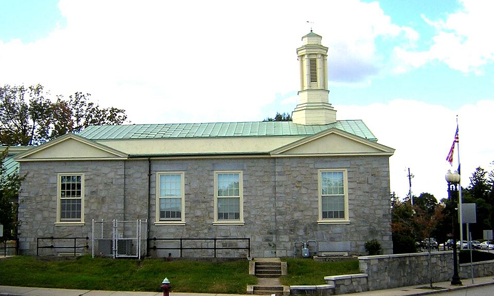
“The Milton Main Post Office is a historic post office building at 499 Adams Street in Milton, Massachusetts. Built in 1936, the building is a good example of Great Depression-era public works projects, and a fine local example of Colonial Revival architecture.”
Wikipedia article United States Post Office-Milton Main, CC BY-SA 4.0.
one of 249 National Register listings in Norfolk County · listed in 1986 · category: Building · one of 2 National Historic Landmarks in Norfolk County.
National Register reference number.86001213- the number the National Park Service assigned this property when it was listed, and the key its nomination file is catalogued under at the National Archives.
Mr. Hunt was born in Scott's Woods, Milton. He is remembered with great affection as connected with the Sabbath School of the First Evangelical Church in his boyhood. The pastor of this church has followed him with the watchful interest of a sincere friend in his education and progress onward to the place he now occupies.
Since the above date a handsome church edifice has been erected on the Dorchester side, where the shepherd gathers his Milton and Dorchester flock. May the prophetic words come to pass : " There shall they lie in a good fold, and in a fat pasture shall they feed." - Ezekicl xxxiv. 14.
Regional context, not property-specific
evidence. The
federal wildfire occurrence database
lists 208 fires within 5 miles of US Post Office--Milton Main between
2015 and 2020, burning about 116 acres in total. None started naturally. None was recorded as arson.
Distance is straight-line from the map coordinates, so a fire counted
here may appear on a neighbouring settlement's page as well.
Reported cause
Fires
Recreation and ceremony
152
Smoking
34
Missing data/not specified/undetermined
17
Debris and open burning
3
Equipment and vehicle use
2
The most recent of
them, most recent first, with the day each was reported and the service
that recorded it.
Regional context, not property-specific
evidence. Museums hold 12,271 specimens
collected within 10 miles of US Post Office--Milton Main between 1810 and
1975: 5,524 Plantae, 3,116 Fungi, 2,990 Animalia, 354 Chromista, 203 Protozoa, 54 Unrecorded, 30 Bacteria. 12 distinct Species records are shown.
Collected by (MARSDEN, H W), ?, A C Gibson and others. Each is a
physical object with a catalogue
number, and each entry opens the museum's record. This is what was
collected and kept, not a survey of what lives here - nothing can be
concluded from a species being absent.
Regional context, not property-specific
evidence. The federal mineral resources record lists
3 workings within 5 miles of US Post Office--Milton Main: 2 producers, 1 past producer.
2 still produce. What was taken out: Granite, Stone, Crushed/Broken, Sand and Gravel, Construction. Distance is straight-line from the
map coordinates, so a quarry counted here may appear on a neighbouring
settlement's page as well.
Regional context, not property-specific
evidence. The National Weather Service names
Milton, the town this property stands in, in 21 storm reports between 1996 and 2025: 9 thunderstorm wind, 5 lightning, 4 heavy rain, 1 hail.
The reports record 3 injuries. Each account below is quoted exactly as the forecast office
filed it, from the NOAA Storm Events Database, and each date
opens the federal record of that event.
Lightning struck a house on Augusta Road, causing a fire that engulfed the entire third floor of the house. No one was home at the time of the fire. Three firefighters were hospitalized for heat exhaustion but were released less than 24 hours later.
No historic map-sheet match is published
for this property yet. That does not mean no map exists. This record needs
a coordinate-quality review before it can be joined to a sheet boundary.
Browse the county's mapped places while that work is
pending.
Named in the fire insurance atlases
Sanborn surveyors printed an index of the
town's establishments at the front of each atlas. This property is named in
one, read straight off the scanned sheet.
When this property was proposed for the
National Register, someone wrote the case for it: what the building is,
and why it matters. That document is a federal record in the public domain.
It is quoted below word for word, never summarised. The text was read off the scanned case file by machine, so the
occasional stray character is the recogniser's and the 1970s
typewriter's.
Description of the property
_PHYSICAL APPEARANCE_ The building and its property are in good condition. The post office is on the front (northern) portion of the lot with a paved vehicle maneuvering area to its rear. The site is landscaped with lawn and several shrubs; driveways to the rear provide access to Edge Hill Road and Hollis Street. The building is constructed of local quarried granite with oversized blocks acting as lintels. The gable ends are of stucco; the copper-covered pitched roof is topped by a highly detailed cupola. In plan, the building has a small vestibule leading to a public lobby, flanked by the Postmaster's office to the right and workroom space to the left. Behind the service screen is the workroom with a mail vestabule and platform beyond.
Fifteen steps with wrought-iron railings create the main approach. The front (north) elevation is a five-bay structure with a higher, pedimented three-bay projecting central entranceway which breaks down the volume of the building. The building's base is of projecting ashlar granite. Iwo replacement aluminum and glass doors are framed by original sidelights and fanlight,all set within an arched recess with large granite voussoirs. Oversized iron and glass electric lanterns flank the opening. This section is topped by a pediment with a carving of an eagle between two hatchets. Above the gable roof is a cupola of wood construction, circular in plan, with louvered side panels and a copper roof. Windows are double-hung, wood sash with 12/12 lights, large lintels and thin sills.
The east and west elevations are similar in detail to the front facade. Four bays long, the end bays are topped by smaller, plain gabled roofs with a flat roof in between. The southfacade has the mail platform. One enters into a highly carved, stained wood vestibule.
Dedication: January 27, 193%UILDER/ARCHITECT Louis A. Simon, Supervising Archi- tect Overlooking the Southeast Expressway, the Milton Main Post Office serves as an attractive gateway to the architecturally rich residential areas, to the West, bordering Brook and Edgehill Roads. Built in 1936, it is architecturally significant as a representative of the construction and design policies of the Public Works Administration (P.W.A.) during the late 1930's. Although it is slightly less than fifty (50) years old it is important as an example of P.W.A. Supervising Architect, Louis Adolf Simon's efforts to use local building materials, standardized construction methods and streamlined, etticient plans.
In addition, this building contains an important mural by Guggenheim Fellowship winner, Ellzabeth Tracy of Cambridge, MA. This building is of a simple Colonial Revival design of the type employed in late 1930's post offices. Its simple, compact T-shaped form and logical 5-area plan facilitated a construction schedule of only seven months. It was the P.W.A.'s policy to build a post office as quickly as possible so that communities could benefit from them during the Depression. In keeping with government policy of the time, walls were constructed of local granite rather than an expensive imported stone. Ornamentation is minimal and limited to the ecliptical arched entrance enrichment.
This structure is dominated by a Colonial Revival cupola which serves as local landmark and more abstractly as a symbol of the Federal Government. This building's design originated in the office of U.S. Supervising Architect, Louis Adolf Simon (c. 1870-1941). He was born in Boston and educated at M.I.T. He began a private practice in Washington, D.C. in 1894 and entered the office of the U.S. Treasury Supervising Architect in 1896. He served as the chief architect in this office from 1905-1933. From 1933 until his death in 1941, he was the U.S.
Quoted from the National Register nomination
for reference 86001213, 17 pages, held by the National Archives in Record
Group 79. See the
catalogue record.
Listed places nearby
6 within 8 miles
Other National Register properties close
enough to walk or drive between, ordered by distance from this one. Both
positions come from the same geocoding pass that matched these properties
to their map sheets.
Listing record. National Park Service National Register of Historic Places, listed-properties dataset, current to 2026-05-22.
Map join. Address geocoded through the United States Census geocoder, then tested against the published boundary of every sheet in the USGS Historical Topographic Map Collection.
How this page is made. Listing fields come from federal records; map-sheet coverage is a labelled coordinate-to-boundary calculation, not a source-field claim.
Wildfire. Short, Karen C. 2022. Spatial wildfire occurrence data for the United States, 1992-2020 [FPA_FOD_20221014]. 6th Edition. Fort Collins, CO: Forest Service Research Data Archive. https://doi.org/10.2737/RDS-2013-0009.6 Collected with United States Government funding and usable without additional permissions or fees.
Specimens. Global Biodiversity Information Facility (GBIF), https://www.gbif.org/. Only records licensed CC0 or CC BY are used. Records licensed CC BY-NC are excluded because this site carries advertising. Images are checked individually and any whose licence is non-commercial, no-derivatives or unreadable is refused.
Mines and quarries. USGS Mineral Resources Data System (MRDS) https://mrdata.usgs.gov/mrds/ A work of the United States government, no copyright under 17 U.S.C. 105.
Storms. NOAA National Centers for Environmental Information, Storm Events Database https://www.ncei.noaa.gov/stormevents/ A work of the United States government, no copyright under 17 U.S.C. 105. Narratives are quoted verbatim from the National Weather Service report and are not edited or summarised.
 Block
Block