Listed on the National Register of Historic Places in
1982. A historic map-sheet match is not published yet. The record needs a coordinate-quality review before it can be joined to a sheet boundary.
From the record
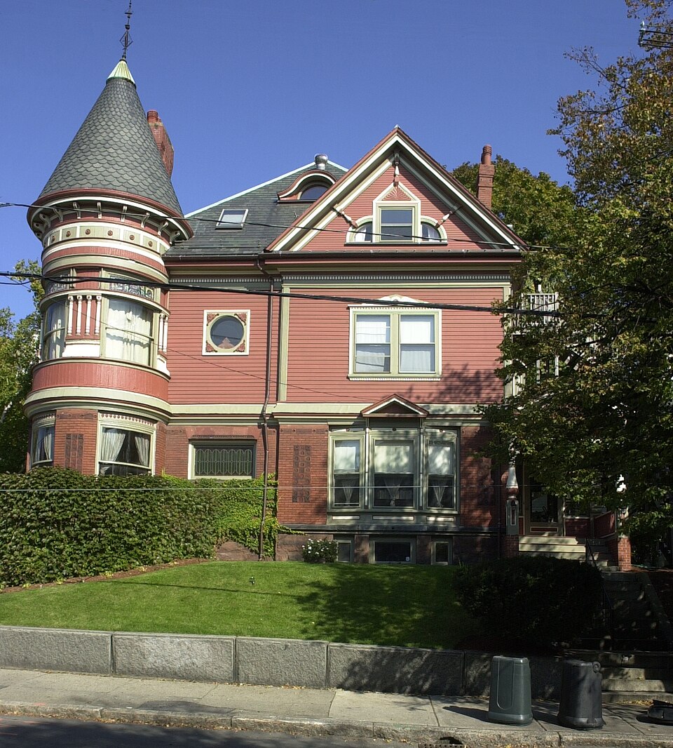
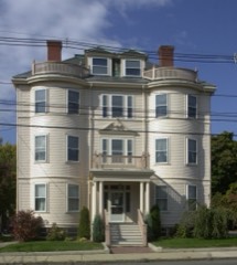
“Henry Kimball House is an historic house at 295 Washington Avenue in Chelsea, Massachusetts. The wood-frame house was built c. 1896, and is one of the city's finest Queen Anne Victorian houses.”
Wikipedia article C. Henry Kimball House, CC BY-SA 4.0.
one of 206 National Register listings in Suffolk County · listed in 1982 · category: Building · one of 5 National Historic Landmarks in Suffolk County.
Architectural style. Queen Anne style architecture in the United States
National Register reference number.82004464- the number the National Park Service assigned this property when it was listed, and the key its nomination file is catalogued under at the National Archives.
Chehsea, then comprising Chelsea, Revere and Winthrop, was set off from Boston in 1739. The Post-Office at Chelsea was established July 0, 1833. In 1846 North Chelsea, comprising Revere and Winthrop, was set off. In 1857 Chelsea became a City. It covers about 1,440 acres, has about 30,000 inhabitants (August 1, 1893), 5,000 houses, fifty miles of streets, and the highest point rises two hundred and twenty feet above sea level.
The first Postmaster at Chelsea was Horatio Alger (the Otffcial Registers call him Algier), father of the story teller. He served until March 31, 1843. His successor was Abel Bowen. From 1844 to 1850 Benjamin Dodge served. Mrs. Sarah A. Newell was Postmaster from 1850 to 1854; Gideon W. Young from 1854 to 1861; Hadley P. Burrill from 1861 to 1869; Clifton A. Blanchard from 1869 to June 30, 1873, when the independent Post-Otficc ceased, being changed to a Station of the Boston Post-OiSce.
Regional context, not property-specific
evidence. The
federal wildfire occurrence database
lists 46 fires within 5 miles of Kimball, C. Henry, House between
2015 and 2020, burning about 24 acres in total. None started naturally. 7 were recorded as arson.
Distance is straight-line from the map coordinates, so a fire counted
here may appear on a neighbouring settlement's page as well.
Reported cause
Fires
Missing data/not specified/undetermined
16
Debris and open burning
12
Arson/incendiarism
7
Recreation and ceremony
6
Smoking
4
Misuse of fire by a minor
1
The most recent of
them, most recent first, with the day each was reported and the service
that recorded it.
Regional context, not property-specific
evidence. Museums hold 15,566 specimens
collected within 10 miles of Kimball, C. Henry, House between 1810 and
1975: 7,158 Plantae, 3,848 Fungi, 2,754 Animalia, 1,280 Chromista, 229 Bacteria, 180 Protozoa, 117 Unrecorded. 12 distinct Species records are shown.
Collected by ?, A B Seymour, A C Gibson and others. Each is a
physical object with a catalogue
number, and each entry opens the museum's record. This is what was
collected and kept, not a survey of what lives here - nothing can be
concluded from a species being absent.
Regional context, not property-specific
evidence. The federal mineral resources record lists
14 workings within 5 miles of Kimball, C. Henry, House: 9 plants, 2 past producers, 2 producers, 1 unknown.
11 still produce. What was taken out: Iron, Lead, Stone, Crushed/Broken, Gypsum-Anhydrite. Distance is straight-line from the
map coordinates, so a quarry counted here may appear on a neighbouring
settlement's page as well.
Regional context, not property-specific
evidence. The National Weather Service names
Chelsea, the town this property stands in, in 10 storm reports between 2006 and 2023: 5 flood, 2 thunderstorm wind, 2 flash flood, 1 tornado.
The reports record 2 injuries. Each account below is quoted exactly as the forecast office
filed it, from the NOAA Storm Events Database, and each date
opens the federal record of that event.
The tornado touched down in Chelsea, where a window was blown out on Dudley Street. However, the overwhelming majority of damage occurred in Revere. Most of the damage was rated EF-1, but EF-2 rated damage did occur near Revere Beach Parkway. ||From Chelsea, the tornado moved across the Chelsea River, directly across the Paul Cronin Memorial Skating Rink. Portions of the rink's roof were blown northeastward across Route 16. Numerous houses on Revere Beach Parkway were damaged, with one roof blown completely off. In that same area, large oak trees were snapped in half. Numerous trees were downed, some of which were lifted up and then deposited on top of houses immediately behind Revere Beach Parkway.||The damage was widespread throughout much of the center of Revere. The tornado traveled northward, following Route 107 or Broadway for the most part. Windows were blown out of town hall and the roof was damaged. A large birch tree was uprooted near town hall. Sixty-four structures sustained damage that ranged from siding torn off to roofs lifted or blown off. Thirteen of these structures (6 - 1 & 2 family homes, 3 - multifamily homes, and 4 commercial buildings) were deemed uninhabitable by building inspectors. Several store signs were destroyed. Debris from homes collected on fences. Trees fell on cars, a few of these crushed.||Revere High School also sustained damage, mainly to the exterior. Side panels, fencing, sidewalks, and air handlers on the roof were damaged.||Police reported a car that had been overturned at the intersection of Revere Street and Carleton Avenue. Finally, near the rotary at Route 60 and Broadway, a billboard was blown onto several cars.||City officials estimated that city owned buildings alone sustained at least 1.5 to 2 million dollars of damage. ||While no major injuries were reported, several minor injuries occurred. An 86 year old woman suffered from a head laceration which she sustained from flying debris while standing outside a Dunkin Donuts. A two week old baby girl strapped in the back seat of a truck was injured when a board flew through the rear windshield of the vehicle. The board missed the infant but covered her in broken glass.
At 749 AM EST in the Orient Heights section of Boston, multiple basements on Ashley and Bennington Streets were flooded and the backyards had 3 to 4 feet of water.
In Chelsea, cars were stuck in flood waters near Third Street. Several streets were closed due to flooding including: Second Street, Willow Street, Vale Street, and Third Street.
At 717 PM EST, Carter Street in Chelsea was under a foot and a half of water between Addison Street and Beech Street. At 724 PM, the Revere Beach Parkway eastbound near Webster Avenue was closed due to flooding.
At 621 PM EST, an emergency manager reported widespread flooding through the city of Chelsea, resulting in manhole covers popping off. At 631 PM EST, amateur radio operators reported Second Street, Shurtleff Street, and Vale Street were all flooded and impassable.
No historic map-sheet match is published
for this property yet. That does not mean no map exists. This record needs
a coordinate-quality review before it can be joined to a sheet boundary.
Browse the county's mapped places while that work is
pending.
From the nomination file
3,266 words on record
When this property was proposed for the
National Register, someone wrote the case for it: what the building is,
and why it matters. That document is a federal record in the public domain.
It is quoted below word for word, never summarised. The text was read off the scanned case file by machine, so the
occasional stray character is the recogniser's and the 1970s
typewriter's.
Description of the property
The C. Henry Kimball House in Chelsea, Massachusetts, is sited on a ca. 10,000 square foot lot with about 116 feet of frontage on the northeast corner of Washington and Jefferson Avenues. The house is set back about 25 feet from both streets. Its location is such that while it is close to abutting properties, it maintains a sense of autonomy through grade changes and landscaping. The immediatearea in which the Kimball House is located contains other residential structures which, though similar in scale, are not of equal architectural quality. The overall effect of the neighborhood is that of an important upper middle class district of the second half of the nineteenth century. The Kimball House, built ca. 1880, is Queen Anne in style.
Its architect is unknown al- though an 1898 Chelsea history states that Kimball himself planned it. Two and one half stories in height, the house has the irregular plan, including round and rectangular bays, a round corner towner, and complex gabled roof line which is characteristic of the style. Also typical is the use of a variety of building materials. The foundation is of brick, fieldstone, and vermiculated brownstone while the elaborate wood detailing, particularly on the side entrance porches, and decorative panels of glazed brick.
Above the first floor, and separated from it by a molded wooden string course, the walls are clapboarded except for some flush boarding in the gable fields; inset wood panels on window bays; and elaborate wood panelling and vertical flush boarding in the second story of the corner tower. The dentillated wood cornice which extends around the entire roof with a deep, bracketted overhang. The main roof and dormers are covered with colored include round cut slates.
/Architect C. Henry Kimbakl Statement of Significance (in one paragraph) The Kimball House possess integrity of location, design, setting and materials and is an excellent example of the Queen Anne style of architecture, meeting criterion C. Its signficance lies not only in the very great degree to which it remains intact as an ex- socturat caltbre anf Entertop worknenshtp suryiving in thid tan Boston. (see section 7 for an analysis of particular features). C. Henry Kimball, the builder, (and some say the planner): of the house, succeeded his father, known as the "potatoe king" in 1885, invented a heating system for railroad cars which revolutionized the transpor- The younger Kimball tation of potatoes and earned him a fortune in his own right.
Kimball's subsequent business dealings included the organization of the Van Choate Electric Co., one of the pioneer electric companies of the era. In addition to being an inventor of considerable importance and fame, Kimball was also a social sciéntist and devoted much of the energy of his later life to the reorganization of publicly held companies so that they might be more responsive to the interests of the small investor./ He was long concerned with the abuses of corporate power which he perceived in his business dealings. This desire to correct such abuses was particularly evident in the operation of the Van Choate Electric Co. of which he was a major stockholder. He also helped organize the Boston Fruit and Produce Exchange of which he was long a member.
Quoted from the National Register nomination
for reference 82004464, 12 pages, held by the National Archives in Record
Group 79. See the
catalogue record.
Listed places nearby
6 within 8 miles
Other National Register properties close
enough to walk or drive between, ordered by distance from this one. Both
positions come from the same geocoding pass that matched these properties
to their map sheets.
Listing record. National Park Service National Register of Historic Places, listed-properties dataset, current to 2026-05-22.
Map join. Address geocoded through the United States Census geocoder, then tested against the published boundary of every sheet in the USGS Historical Topographic Map Collection.
How this page is made. Listing fields come from federal records; map-sheet coverage is a labelled coordinate-to-boundary calculation, not a source-field claim.
Wildfire. Short, Karen C. 2022. Spatial wildfire occurrence data for the United States, 1992-2020 [FPA_FOD_20221014]. 6th Edition. Fort Collins, CO: Forest Service Research Data Archive. https://doi.org/10.2737/RDS-2013-0009.6 Collected with United States Government funding and usable without additional permissions or fees.
Specimens. Global Biodiversity Information Facility (GBIF), https://www.gbif.org/. Only records licensed CC0 or CC BY are used. Records licensed CC BY-NC are excluded because this site carries advertising. Images are checked individually and any whose licence is non-commercial, no-derivatives or unreadable is refused.
Mines and quarries. USGS Mineral Resources Data System (MRDS) https://mrdata.usgs.gov/mrds/ A work of the United States government, no copyright under 17 U.S.C. 105.
Storms. NOAA National Centers for Environmental Information, Storm Events Database https://www.ncei.noaa.gov/stormevents/ A work of the United States government, no copyright under 17 U.S.C. 105. Narratives are quoted verbatim from the National Weather Service report and are not edited or summarised.
 Block
Block