Photographs from the nomination case file, National Park Service records.
South Framingham Common
Listed on the National Register of Historic Places in
1983. A historic map-sheet match is not published yet. The record needs a coordinate-quality review before it can be joined to a sheet boundary.
From the record
“Twenty-live years ago South Kraminghaui liad already shown signs of an ambition to be something more than the unjiretentious farming village of earlier days. 'I'hus more than ten years before the war the village bad become a point of some size on the railroad mai) of the State. lUit it was destined to become at an early day one of the greatest of New England railroad centres.”
History of Middlesex County, Massachusetts, with Biographical Sketches of Many of Its Pioneers and Prominent Men (1890). Machine-read text.
one of 1100 National Register listings in Middlesex County · listed in 1983 · category: Site · one of 3 National Historic Landmarks in Middlesex County.
National Register reference number.83000794- the number the National Park Service assigned this property when it was listed, and the key its nomination file is catalogued under at the National Archives.
May 22, 1701. The town "voted to give a call to Mr. John Swift to abide and settle with us, the inhabitants of Framingham, as our legal minister." Chose Abial l^amb, David Rice, Benjamin Bridges, John Town, John Haven, Peter Cloyce, Sen., Samuel Winch and Thomas Drury to give the call in behalf of the inhabitants.
As a result of the contest about the ministerial land, growing out of the claim and seizure of said lands by the lessee of Mr. Danforth, a divided sentiment had obtained in the church, aggravated by difficulties with the first pastor. The settlement of a new minister was the occasion of the culmination of the alienated feeling. The majority was uncompromising, and the minority seceded and took steps which led to the organization of a .second Congregational Church in October, 174G. A small meeting-house was built, and Mr. Solomon Reed was ordained pastor of the new church in January, 1747. The new organization numbered over eighty members, and maintained a separate existence about ten years, when a part returned to the old church and a part united in forming the Fir.st Baptist Society in Framingham.
Regional context, not property-specific
evidence. The
federal wildfire occurrence database
lists 137 fires within 5 miles of South Framingham Common between
2006 and 2020, burning about 60 acres in total. 3 started naturally. 6 were recorded as arson.
Distance is straight-line from the map coordinates, so a fire counted
here may appear on a neighbouring settlement's page as well.
Reported cause
Fires
Debris and open burning
54
Missing data/not specified/undetermined
42
Recreation and ceremony
12
Power generation/transmission/distribution
7
Arson/incendiarism
6
Misuse of fire by a minor
4
Natural
3
Railroad operations and maintenance
3
Smoking
3
Other causes
1
Fireworks
1
Equipment and vehicle use
1
The most recent of
them, most recent first, with the day each was reported and the service
that recorded it.
Regional context, not property-specific
evidence. Museums hold 1,085 specimens
collected within 10 miles of South Framingham Common between 1898 and
1975: 844 Animalia, 167 Plantae, 70 Fungi, 4 Chromista. 12 distinct Species records are shown.
Collected by A. B. Seymour, A. F. Newton, A. L. Bosworth and others. Each is a
physical object with a catalogue
number, and each entry opens the museum's record. This is what was
collected and kept, not a survey of what lives here - nothing can be
concluded from a species being absent.
Regional context, not property-specific
evidence. The federal mineral resources record lists
19 workings within 5 miles of South Framingham Common: 13 past producers, 3 producers, 2 plants, 1 unknown.
5 still produce. What was taken out: Sand and Gravel, Construction, Granite, Iron, Stone, Crushed/Broken. Distance is straight-line from the
map coordinates, so a quarry counted here may appear on a neighbouring
settlement's page as well.
Regional context, not property-specific
evidence. The National Weather Service names
Framingham, the town this property stands in, in 30 storm reports between 1993 and 2024: 10 thunderstorm wind, 9 flood, 6 hail, 2 lightning.
The reports record 1 injury. Each account below is quoted exactly as the forecast office
filed it, from the NOAA Storm Events Database, and each date
opens the federal record of that event.
Numerous trees and limbs were downed by thunderstorm winds on the south side of Framingham. A tree fell on a person on Beaver Street. The person sustained minor injuries.
Pearl, Sanger, Waverly, Beech, Henry and Thompson Streets and Union Avenue were all flooded and impassable. Cars were stuck in flood waters on Union Avenue. Waverly Street was closed near Marble Street where several cars were stuck. Cars were stuck in flood waters on Route 9, Union Avenue, Beech Street, and Henry Street. The intersection of Bishop Street and Lawrence Street was closed. Several cars were stuck in flood waters. Parts of Route 9 were flooded with four to five feet of water.
Another round of heavy rain resulted in renewed flooding across Wellesley and Natick. Information on flooding in Wellesley can be found in a similar report for Norfolk County. In Natick, a car became stuck in flood waters on South Main Street. Flooding occurred under the Willow Bridge. Route 9 near the Natick Police Department, Pearl Street, and Plain Streets were all flooded and impassable.
Route 9 was flooded in both directions at Route 126, making Route 9 impassable. Speen Street at Cochituate Road was also flooded with a car stuck in the flood waters there.
In Framingham, Rt 9 (Worcester Rd) at Rt 126, as well as the ramps on Rt 126 were closed due to flooding. A car was stuck at this intersection. Also, Gates St at Parker Rd was impassable.
Thunderstorms produced weak wet microbursts across the Southern portion of Middlesex County on the afternoon on the 29th. Trees were downed in Framingham where a tree split a car in half. Trees were also downed in Sherborn and Ashland which resulted in power outages.
Numerous wires and trees down in Framingham...especially the south side of town. Lightning caused a fire resulting in extensive damage to a home. Additionally, there were unconfirmed funnel cloud sightings this evening in Arlington Heights, Concord and Stoneham and in all of Boston's north and northwest suburbs. There were numerous reports of pea- to marble-size hail from southeast Middlesex and southern Essex Counties between 1744 EST and approximately 1945 EST, mainly from the northwest to northeast of Boston. Lightning caused numerous power outages and fires but were unable to be detailed due to unknown times and lack of detailed data. Torrential rains fell in parts of Boston's northern suburbs near Route 128.
No historic map-sheet match is published
for this property yet. That does not mean no map exists. This record needs
a coordinate-quality review before it can be joined to a sheet boundary.
Browse the county's mapped places while that work is
pending.
From the nomination file
5,123 words on record
When this property was proposed for the
National Register, someone wrote the case for it: what the building is,
and why it matters. That document is a federal record in the public domain.
It is quoted below word for word, never summarised. The text was read off the scanned case file by machine, so the
occasional stray character is the recogniser's and the 1970s
typewriter's.
Description of the property
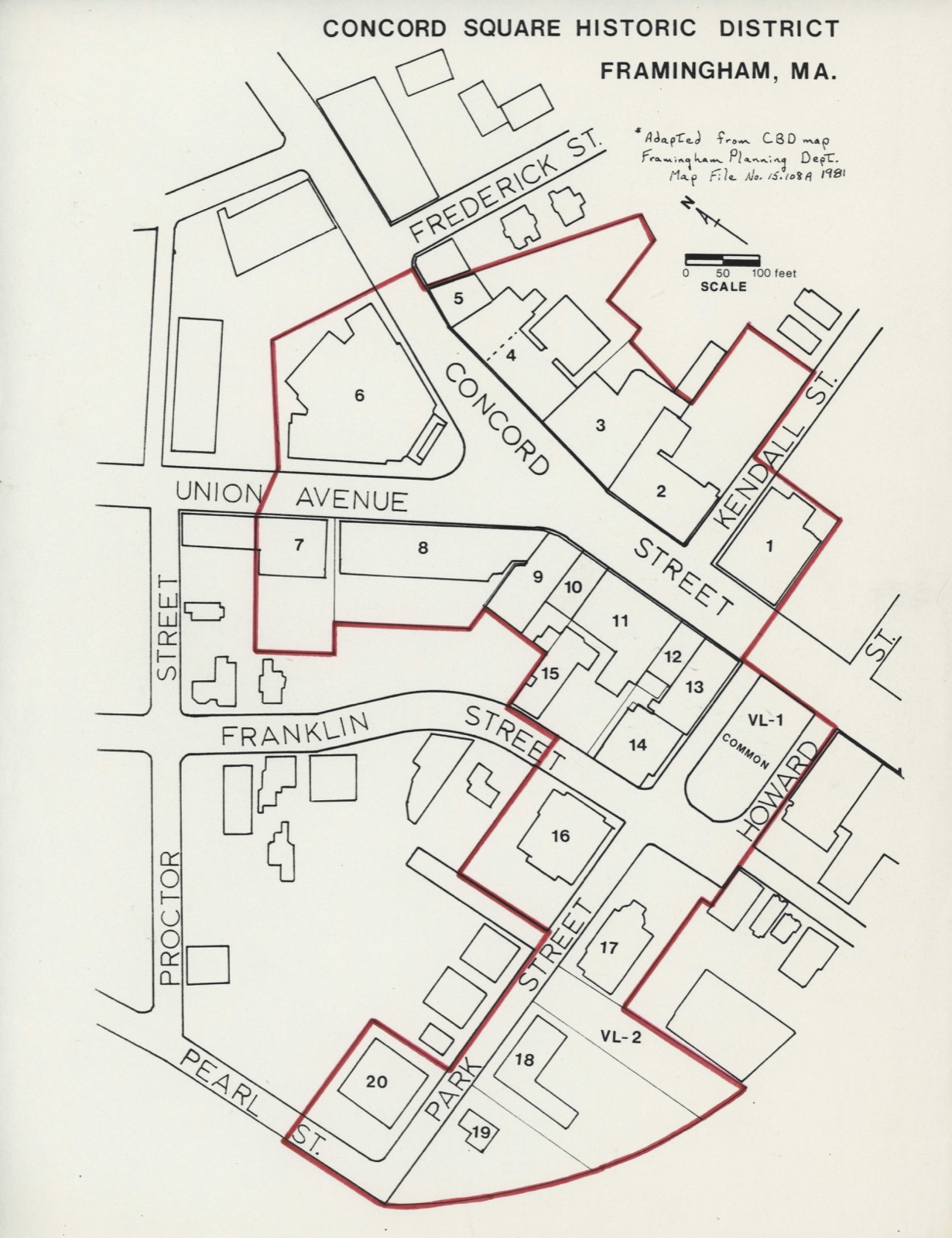
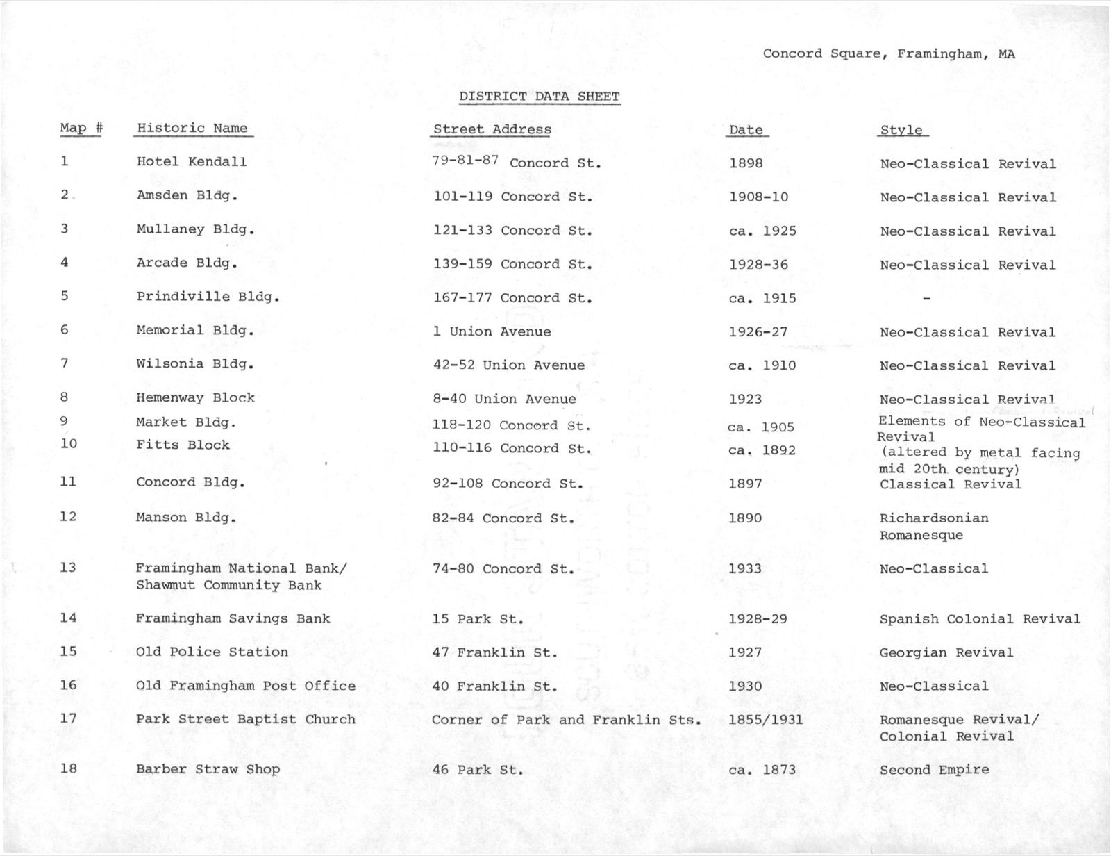
The Concord Square Historic District is located on the north side of the railroad tracks which bisect South Framingham. Encompassing approximately 14 acres, the district includes twenty commercial, civic and institutional buildings loosely grouped around a common and th wide intersection of Unicn Avenue and Concord Street. The majority of the buildings were erected between 1890 and 1930; most are masonry structures standing two to four stories high and designed in the Classical Revival styles popular at the turn of the century. Ground floor storefronts have been altered on all of the commercial structures but the upper stories are largely unchanged. Two of the buildings in the district pre-date this period of major commercial construction.
The Park Streeet Baptist Church (#17; Photo #4) was built in 1855 under the supervision of local architect Alexander Rice Esty. Esty's Romanesque Revival design was radically altered in 1930-31 when the church was remodeled; the original tower and spire were removed due to structural problems and replaced by a classically-designed cupola. The chuurch is sited at the western end of the small, U-shaped common. Set aside in 1854, the common today 1s the only open space in the downtown. It is enclosed by a ralling consisting of rough-faced granite posts that support two parallel iron bars with simple embellishments. Although the common was once the site of a Native American burial ground, an archaeological reconnaissance survey in 1979 determined that the area has been extensively disturbed.
Directly behind the church is the Barber Straw Shop (#18, ca.1873), a three-story frame block with a mansard roof and a three-story rear ell.
(in one paragraph) Builder/Architect Alexender Esty, Peabody & Stearns, E.W. Norton, Thomas M. James James A. Wetmore The Concord Square Historic District possesses integrity of location, design, setting material y workmanship and Ieeling. The district is associated with the development of South Framingham as the commercial and civic center of Framingham and lt embodles the distinctive characteristics of late 19th - early 20th century commercial architecture of smaller urban communities. The Concord Square Historic District thus meets criteria A and C of the National Register of Historic Places. The development of Concord Square is directly related to the arrival of the Boston- Worcester railroad in South Framingham in 1834.
At the time the railroad was laid out, civic, commercial and religious activity was concentrated in Framingham Center, located two miles farther north and strategically sited on the Boston & Worcester Turnpike (present-day Route 9) which opened in 1809. Though South Framingham was also located on a turpike, the Central Turnpike (present day Waverly Street) did not open until 1830, almost immediately meeting intense competition from the railroad. In 1832 the village of South Framingham consisted of a meager cluster of bulldings, containing a tavern, cider mill, shoe shop and less than a dozen houses. The initial plan for the railroad's path was to parallel the Boston and Worcester Kumpike through Framingham Center.
However, strong opposition trom the turnpike company and residents of the center caused the rallbed to divert in a southerly direction and pass through South Framingham. The decision proved to be a momentous turing point for the town. As the midway point between Boston and Worcester, the South Framingham station became a busy resting spot and railroad juncture.
Quoted from the National Register nomination
for reference 83000794, 28 pages, held by the National Archives in Record
Group 79. See the
catalogue record.
Listed places nearby
6 within 8 miles
Other National Register properties close
enough to walk or drive between, ordered by distance from this one. Both
positions come from the same geocoding pass that matched these properties
to their map sheets.
Listing record. National Park Service National Register of Historic Places, listed-properties dataset, current to 2026-05-22.
Map join. Address geocoded through the United States Census geocoder, then tested against the published boundary of every sheet in the USGS Historical Topographic Map Collection.
How this page is made. Listing fields come from federal records; map-sheet coverage is a labelled coordinate-to-boundary calculation, not a source-field claim.
Wildfire. Short, Karen C. 2022. Spatial wildfire occurrence data for the United States, 1992-2020 [FPA_FOD_20221014]. 6th Edition. Fort Collins, CO: Forest Service Research Data Archive. https://doi.org/10.2737/RDS-2013-0009.6 Collected with United States Government funding and usable without additional permissions or fees.
Specimens. Global Biodiversity Information Facility (GBIF), https://www.gbif.org/. Only records licensed CC0 or CC BY are used. Records licensed CC BY-NC are excluded because this site carries advertising. Images are checked individually and any whose licence is non-commercial, no-derivatives or unreadable is refused.
Mines and quarries. USGS Mineral Resources Data System (MRDS) https://mrdata.usgs.gov/mrds/ A work of the United States government, no copyright under 17 U.S.C. 105.
Storms. NOAA National Centers for Environmental Information, Storm Events Database https://www.ncei.noaa.gov/stormevents/ A work of the United States government, no copyright under 17 U.S.C. 105. Narratives are quoted verbatim from the National Weather Service report and are not edited or summarised.
 Block
Block