Photographs from the nomination case file, National Park Service records.
Worcester House
Listed on the National Register of Historic Places in
1983. A historic map-sheet match is not published yet. The record needs a coordinate-quality review before it can be joined to a sheet boundary.
From the record
“(VII) Daniel Smith Gray, son of Timothy Gray (6), born in Wilton, New Hampshire, October 6, 1816, died October 9, 1900, at Lowell. He attended the district schools of his native town, and remained at home working on his father's farm until he was about twenty years of age.”
Historic Homes and Places and Genealogical and Personal Memoirs Relating to the Families of Middlesex County, Massachusetts ; (1908). Machine-read text.
one of 1100 National Register listings in Middlesex County · listed in 1983 · category: Building · one of 3 National Historic Landmarks in Middlesex County.
National Register reference number.83004091- the number the National Park Service assigned this property when it was listed, and the key its nomination file is catalogued under at the National Archives.
It appears that immediately after ilr. Lowell's return he had at once gone to work to construct a loom ; but he found its construction no easy task. Without patterns, or even drawings, so far as we know, each part had to be planned and tried, altered and rearranged, until tlie whole assumed the shape of a machine. We are told that " many little matters were to be overcome or adjusted before it would work perfectly." Mr. Appleton says : " Mr. Lowell said to me that he did not wish me to see it until it was complete, of whicli he would give me notice. At length the time arrived. He invited me to go out with him and see the loom operate. I well recollect the state of admiration and satisfaction with which we sat by the hour watching the beautiful movement of this new and wonderful machine, destined, as it evidently was, to change the character of all textile industry. This was in the autumn of 1814."
The great obstacle to tlie use of the power-loom, at that time, proved to be dressing the yarn ; it required a man at each loom to dress the warp as it unrolled from the beam. This rendered it necessary to stop the loom while the man was doing it. This difficulty was removed by the invention of an ingenious mode of dressing the warp before it was placed in the loom. Mr. Lowell procured from England a drawing of Horrocks' dressing-frame, and Mr. Moody, whose services he had secured, made an improvement which more than doubled its efficiency, - a very ingenious machine called a warper, that wound the threads from the bobbins on the beam. After this there was no farther difficulty in running a power-loom.
Regional context, not property-specific
evidence. The
federal wildfire occurrence database
lists 130 fires within 5 miles of Worcester House between
2001 and 2020, burning about 71 acres in total. 4 started naturally. 28 were recorded as arson.
Distance is straight-line from the map coordinates, so a fire counted
here may appear on a neighbouring settlement's page as well.
Reported cause
Fires
Missing data/not specified/undetermined
36
Debris and open burning
28
Arson/incendiarism
28
Recreation and ceremony
16
Equipment and vehicle use
4
Power generation/transmission/distribution
4
Smoking
4
Natural
4
Misuse of fire by a minor
3
Railroad operations and maintenance
2
Other causes
1
The most recent of
them, most recent first, with the day each was reported and the service
that recorded it.
Regional context, not property-specific
evidence. Museums hold 517 specimens
collected within 10 miles of Worcester House between 1898 and
1975: 360 Plantae, 120 Animalia, 31 Fungi, 3 Chromista, 2 Protozoa, 1 Unrecorded. 12 distinct Species records are shown.
Collected by A. C. Mathieson, A. F. Newton, A. F. Newton, M. K. Thayer and others. Each is a
physical object with a catalogue
number, and each entry opens the museum's record. This is what was
collected and kept, not a survey of what lives here - nothing can be
concluded from a species being absent.
Regional context, not property-specific
evidence. The federal mineral resources record lists
21 workings within 5 miles of Worcester House: 9 past producers, 7 producers, 4 plants, 1 unknown.
11 still produce. What was taken out: Sand and Gravel, Construction, Stone, Crushed/Broken, Graphite, Nickel, Gold, Silver, Copper. Distance is straight-line from the
map coordinates, so a quarry counted here may appear on a neighbouring
settlement's page as well.
Regional context, not property-specific
evidence. The National Weather Service names
Lowell, the town this property stands in, in 16 storm reports between 1995 and 2023: 6 thunderstorm wind, 4 flood, 3 lightning, 2 hail.
The reports record 2 injuries. Each account below is quoted exactly as the forecast office
filed it, from the NOAA Storm Events Database, and each date
opens the federal record of that event.
No historic map-sheet match is published
for this property yet. That does not mean no map exists. This record needs
a coordinate-quality review before it can be joined to a sheet boundary.
Browse the county's mapped places while that work is
pending.
From the nomination file
2,643 words on record
When this property was proposed for the
National Register, someone wrote the case for it: what the building is,
and why it matters. That document is a federal record in the public domain.
It is quoted below word for word, never summarised. The text was read off the scanned case file by machine, so the
occasional stray character is the recogniser's and the 1970s
typewriter's.
Description of the property
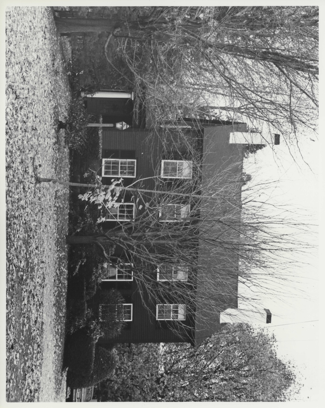
The Worcester House, constructed originally in 1802 in the Federal style with later Greek Revival modifications dating from c 1840, is sited on the north side of Andover Street, facing south. It is located approximately 1½ miles east of Lowell's downtown and 14 miles west of North Tewskbury. The house and its detached barn are set back considerably from Andover Street. The nominated parcel comprises 1.6 acres and includes lawn, woods, and an unpaved drive. The surrounding area was subdivided in the late 19th century with residential construction occurring along Andover Street during the early 20th century and on the side streets mid-century. Prior to that time, it was farmland with a scattering of early-mid 19th century houses.
Andover Street was the 18th century route linking East Chelmsford (now Lowell) and North Tewksbury. The ground plan of the main house is rectangular (A) with a two-story ell at the northeast corner which appears to be original (B). ' Between 1924 and 1936 two additions were constructed, one a two-story extension of the ell (C) and the other a screen porch (D) (see attached or the ell (0) site plan). The additions (C&D), are not considered to be contributing elements. The main house is 2½ stories in height and has a fúll basement beneath it and the ell. The roof is a medium-pitched gable covered with asphalt shingles. The roof of the ell is like- wise gabled, framed perpendicularly to the main house.
Three chimneys rise from the main house: two from in front of the ridge and one from the rear; a fourth chimney projects from the ell extension. The walls are clad in butt end clapboards. The foundation of the main house and ell is granite while that of the extension is fieldstone.
/Architect Unknown Statement of Significance (in one paragraph) The Worcester House and its barn possess integrity of location, design, setting, materials, workmanship, feeling, and association. little-altered vernacular farmhouse with an early barn that has retained vestiges of its saze tearules eo thitn the Cry o T.oke l. The property is significant architecturally as a rural setting, both rare features within the City of Lowell. Historically, the house is associated with Lowell's early agricultural tradition and stands on land associated with an early Tewksbury family for over two hundred years. Thus, the property meets Criteria A and C of the National Register of Historic Places.
The land on which the property stands was part of Tewksbury until 1906 when a large tract was annexed to Lowell. It had been part of a. 3,000 acre grant awarded to the widow of Governor Winthrop in 1641. Bounded by the Concord and Merrimack Rivers on the west and north, the grant had included much of present-day North Tewksbury as well as the annexed lands. In 1691 600 acres were purchased from Mrs. Winthrop by Samuel Hunt who, through his efforts to incorporate the town, is generally recognized as the "Father of Iewksbury." In 1748 Moses Worcester (d. 1756) bought sixty-five acres from Hunt; his descendents re- mained here until 1954. Moses and his family occupied an early garrison house that had been érected by Hunt.
Known as the "Block House' - It stood on the south side of Andover Street until the early-mid 19th century. According to local historical records of the 1890s, the Worcester House was erected in 1802 by Moses' grandson Eldad (1763-1853).
Quoted from the National Register nomination
for reference 83004091, 11 pages, held by the National Archives in Record
Group 79. See the
catalogue record.
Listed places nearby
6 within 8 miles
Other National Register properties close
enough to walk or drive between, ordered by distance from this one. Both
positions come from the same geocoding pass that matched these properties
to their map sheets.
Listing record. National Park Service National Register of Historic Places, listed-properties dataset, current to 2026-05-22.
Map join. Address geocoded through the United States Census geocoder, then tested against the published boundary of every sheet in the USGS Historical Topographic Map Collection.
How this page is made. Listing fields come from federal records; map-sheet coverage is a labelled coordinate-to-boundary calculation, not a source-field claim.
Wildfire. Short, Karen C. 2022. Spatial wildfire occurrence data for the United States, 1992-2020 [FPA_FOD_20221014]. 6th Edition. Fort Collins, CO: Forest Service Research Data Archive. https://doi.org/10.2737/RDS-2013-0009.6 Collected with United States Government funding and usable without additional permissions or fees.
Specimens. Global Biodiversity Information Facility (GBIF), https://www.gbif.org/. Only records licensed CC0 or CC BY are used. Records licensed CC BY-NC are excluded because this site carries advertising. Images are checked individually and any whose licence is non-commercial, no-derivatives or unreadable is refused.
Mines and quarries. USGS Mineral Resources Data System (MRDS) https://mrdata.usgs.gov/mrds/ A work of the United States government, no copyright under 17 U.S.C. 105.
Storms. NOAA National Centers for Environmental Information, Storm Events Database https://www.ncei.noaa.gov/stormevents/ A work of the United States government, no copyright under 17 U.S.C. 105. Narratives are quoted verbatim from the National Weather Service report and are not edited or summarised.
 Block
Block