Listed on the National Register of Historic Places in
1984. A historic map-sheet match is not published yet. The record needs a coordinate-quality review before it can be joined to a sheet boundary.
From the record
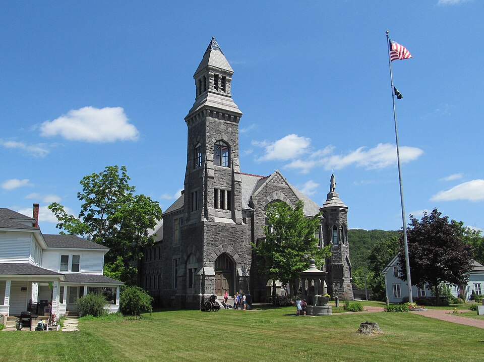
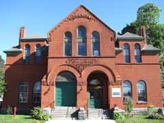
“Memorial Town Hall is the historic town hall of Monson, Massachusetts. Located on Main Street on land donated by the local prominent Reynolds family, the High Victorian Gothic stone building was constructed in 1885 to a design by George Potter.”
Wikipedia article Memorial Town Hall, CC BY-SA 4.0.
one of 123 National Register listings in Hampden County · listed in 1984 · category: Building.
National Register reference number.84002449- the number the National Park Service assigned this property when it was listed, and the key its nomination file is catalogued under at the National Archives.
Fires near this property
40 since 2015
Regional context, not property-specific
evidence. The
federal wildfire occurrence database
lists 40 fires within 5 miles of Memorial Town Hall between
2015 and 2020, burning about 28 acres in total. 8 started naturally. None was recorded as arson.
Distance is straight-line from the map coordinates, so a fire counted
here may appear on a neighbouring settlement's page as well.
Reported cause
Fires
Equipment and vehicle use
22
Natural
8
Recreation and ceremony
5
Missing data/not specified/undetermined
3
Debris and open burning
1
Smoking
1
The most recent of
them, most recent first, with the day each was reported and the service
that recorded it.
Regional context, not property-specific
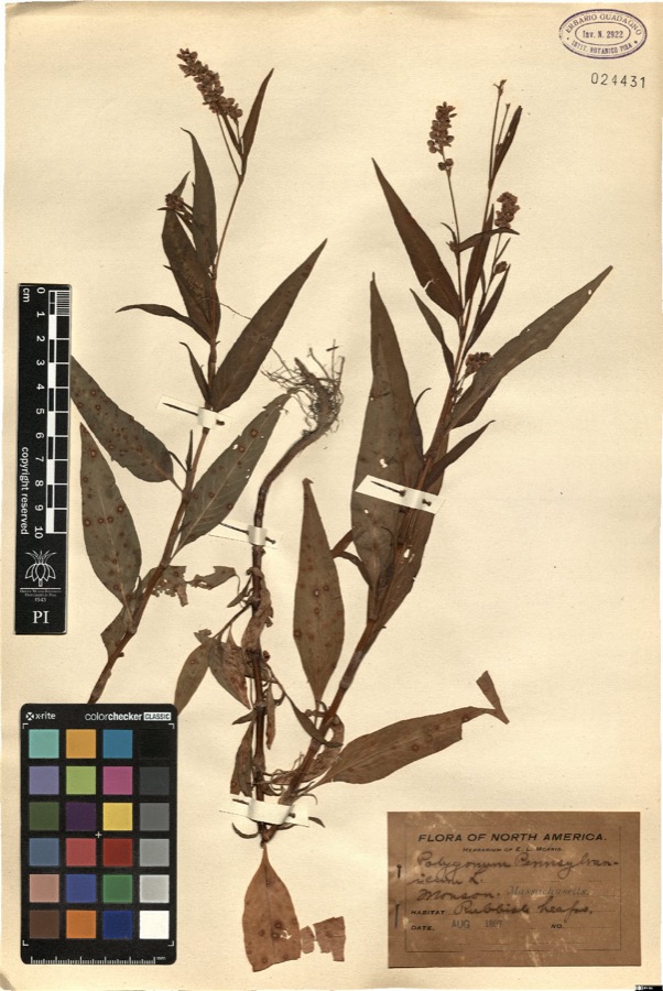
evidence. Museums hold 830 specimens
collected within 10 miles of Memorial Town Hall between 1870 and
1975: 501 Fungi, 191 Plantae, 119 Animalia, 14 Chromista, 5 Unrecorded. 12 distinct Species records are shown.
Collected by A. B. Seymour, A. E. Kirk, A.B. Seymour and others. Each is a
physical object with a catalogue
number, and each entry opens the museum's record. This is what was
collected and kept, not a survey of what lives here - nothing can be
concluded from a species being absent.
Regional context, not property-specific
evidence. The federal mineral resources record lists
8 workings within 5 miles of Memorial Town Hall: 4 past producers, 4 producers.
4 still produce. What was taken out: Sand and Gravel, Construction. Distance is straight-line from the
map coordinates, so a quarry counted here may appear on a neighbouring
settlement's page as well.
Regional context, not property-specific
evidence. The National Weather Service names
Monson, the town this property stands in, in 38 storm reports between 1993 and 2024: 25 thunderstorm wind, 7 hail, 3 lightning, 2 flood.
The reports record 1 injury. Each account below is quoted exactly as the forecast office
filed it, from the NOAA Storm Events Database, and each date
opens the federal record of that event.
A local television station reported that a 16 year old boy was indirectly struck by lightning. Lightning struck the ground and traveled into the metal garage door that the boy was touching. He was transported to the hospital for observation but was reported to be fine.
Three to four inches of rain fell in about 2 hours resulting in the overflowing of several brooks. One of these was Chicopee Brook, which forced the closure of Route 32/Palmer Road. Three roads were washed out and in need of repairs due to the flooding. These include Beebe Road, Palmer Road, and Chestnut Street. Chestnut Street and Beebe Road were closed and Fenton Road was open in only one lane. In addition, a few basements were flooded. In total, nine roads were closed but all were reopened to emergency vehicles and local traffic by 6 pm.
Lightning struck a house on Bethany Road, setting it on fire. Firefighters were able to put the fire out quickly, with damage sustained only to the attic.
In Monson, trees and wires were reported down on Upper Palmer Road at 528 PM EST. Multiple trees and wires and a part of a pole were down on Brimfield Road at Crest Road at 530 PM EST. A tree was down on Town Farm Road at 535 PM EST.
No historic map-sheet match is published
for this property yet. That does not mean no map exists. This record needs
a coordinate-quality review before it can be joined to a sheet boundary.
Browse the county's mapped places while that work is
pending.
From the nomination file
2,799 words on record
When this property was proposed for the
National Register, someone wrote the case for it: what the building is,
and why it matters. That document is a federal record in the public domain.
It is quoted below word for word, never summarised. The text was read off the scanned case file by machine, so the
occasional stray character is the recogniser's and the 1970s
typewriter's.
Description of the property
Monson Memorial Town Hall is located on a one acre lot facing west on Main Street in the town's commercial/civic center. Set back 100 feet from the street on a site which slopes to the east, the building stands on property donated in 1884 by the Reynold's family, Monson's leading industrialists in the 19th century. This large stone structure stands out from its commercial and residential neighbors as an important local landmark. In keeping with its memorial character, two cannons- one from the Civil War, the other from World war I- and a monument grace the front lawn. Memorial Hall was designed in 1885 in the Victorian Gothic style by local architect George Potter.
Although rather complex in its roofline and massing, the Town Hall is basically T shaped in plan with a four story rectangular tower at its northwest corner, an octagonal turret at its southwest corner, a gabled pavillion centered on the facade (west elevation), and a cross gable on the south elevation. This two story structdure is constructed of rock faced random laid granite ashlar. Decorative trim used throughout the building includes heavy stone modillions at the roofline and alternative blue and white granite voussoirs forming the gothic arches which frame most entries and window openings and are a noted feature of the structure. The building is covered by a slate roof which consists of three components.
These include a front hip portion which is broken by a cross gable on the west elevation, a gambrel roof mid-section, and a gable roof at the rear of the building. These roof components also delineate the use of interior space which from front to back are: town offices and GAR Hall, auditorium and balcony, and a stage area. All ridges of the roof are trimmed with copper cresting.
/Architect George E. Potter Statement of Significance (in one paragraph) Monson Memorial Town Hall posseses integrity of location, design, materials, workmanship, setting, and association. It is significant as the community's most important piece of public architecture built of a material (granite) quarried locally, and endowed by a family prominent in Monson during the 19th century. In addition, it possesses enduring associations with the civic development of the community. Thus, the Memorial Hall meets criteria A, B, and C of the National Register of Historic Places. A cornerstone building in the center of Monson, the Memorial Hall building stands as a credit to the town and an honor to the patriot soldiers in whose memory it was designed and built.
The Reynold's family who proposed the project were generous and public-spirited; they conceived of the building to be a lcoal landmark, constructed by local builder's with local materials, for local war heroes. The idea for the Memorial Hall originated at the annual town meeting in 1884. A proposition was made by Rice M. Reynolds to donate a site and along with his brother Ted, both offered to donate $5,000 to the building fund. Their father, Joseph Reynolds, also offered a like sum, on the condition that the town contribute $20,000. It was further stipulated that the building be a memorial structure, be constructed of granite and be completed before May 1, 1885.
The Reynolds family holds a distinguished place in Monson's history; its members were astute businessmen and industrialists and generous, public-spirited citizens. Joseph Reynolds, the patriarch, came to Monson in 1821. He was at the forefront of the industrial revolution, and in his youth, had worked under Eli Whitney, inventor of the cotton gin, at Whitneyville, CT.
Quoted from the National Register nomination
for reference 84002449, 10 pages, held by the National Archives in Record
Group 79. See the
catalogue record.
Listed places nearby
4 within 8 miles
Other National Register properties close
enough to walk or drive between, ordered by distance from this one. Both
positions come from the same geocoding pass that matched these properties
to their map sheets.
Listing record. National Park Service National Register of Historic Places, listed-properties dataset, current to 2026-05-22.
Map join. Address geocoded through the United States Census geocoder, then tested against the published boundary of every sheet in the USGS Historical Topographic Map Collection.
How this page is made. Listing fields come from federal records; map-sheet coverage is a labelled coordinate-to-boundary calculation, not a source-field claim.
Wildfire. Short, Karen C. 2022. Spatial wildfire occurrence data for the United States, 1992-2020 [FPA_FOD_20221014]. 6th Edition. Fort Collins, CO: Forest Service Research Data Archive. https://doi.org/10.2737/RDS-2013-0009.6 Collected with United States Government funding and usable without additional permissions or fees.
Specimens. Global Biodiversity Information Facility (GBIF), https://www.gbif.org/. Only records licensed CC0 or CC BY are used. Records licensed CC BY-NC are excluded because this site carries advertising. Images are checked individually and any whose licence is non-commercial, no-derivatives or unreadable is refused.
Mines and quarries. USGS Mineral Resources Data System (MRDS) https://mrdata.usgs.gov/mrds/ A work of the United States government, no copyright under 17 U.S.C. 105.
Storms. NOAA National Centers for Environmental Information, Storm Events Database https://www.ncei.noaa.gov/stormevents/ A work of the United States government, no copyright under 17 U.S.C. 105. Narratives are quoted verbatim from the National Weather Service report and are not edited or summarised.
 Block
Block