Photographs from the nomination case file, National Park Service records.
Larrabee's Brick Block
Listed on the National Register of Historic Places in
1984. A historic map-sheet match is not published yet. The record needs a coordinate-quality review before it can be joined to a sheet boundary.
From the record
“William Frederick Poole, A.M., LL.D., the eminent librarian and bibliophile, was born in Salem, Massachusetts, December 21, 1821. While in Yale College he became assistant librarian, which was the beginning of a life-long profession.”
History of Middlesex County, Massachusetts, with Biographical Sketches of Many of Its Pioneers and Prominent Men (1890). Machine-read text.
one of 1100 National Register listings in Middlesex County · listed in 1984 · category: Building · one of 3 National Historic Landmarks in Middlesex County.
National Register reference number.84002729- the number the National Park Service assigned this property when it was listed, and the key its nomination file is catalogued under at the National Archives.
Melrose contains a superficial area of about 2,900 square acres, 2,7;iO of which are taxable. It is two and one eighth miles in length, and has an average width of two miles. It is bounded on the north by Wakefield, on the east by Saugus, on the south by Maiden, and on the west by Stoneham and a corner of Medford. It has four villages : Wyoming, at the south part of the town ; tiie Centre ; the Highlands, at the north ; and Norrisville, in the northeastern part. Its surface is charmhigly diversified with hill, valley, pond, and stream. From the summits of a number of its elevations - particularly Boston Rock in the south, Barrett's Mount in the centre, and West Rock, or Vinton Hill, in the north - extensive views of the surrounding country and of the ocean may be had. L Pond, situated in the centre of the town, so named from its shape, contains about thirty acres, and upon its borders are many of the finest residences. This pond received its name as early as 1638, nine years after the settlement of Charlestown, in whose records it is then mentioned ; and it was so called in manv other earlv documents.
It is often spelled "Ell," an undoubted misapprehension from its sound. It has recently been stocked with black bass and alewives by a fishing association under the protection of state law. Long Pond, in the eastern portion of the town, part of which is in Melrose and part in Saugus, is the source of the Saugus River. This and Swain's Pond, in the southeastern part of the town, were named as early as 1660, being then referred to in the Charlestown records. Dix, formerly Little, Pond, near the centre, is small, but it is the legendary pond of Melrose, rumor giving it a fathomless bottom from time immemorial.
Regional context, not property-specific
evidence. The
federal wildfire occurrence database
lists 91 fires within 5 miles of Larrabee's Brick Block between
2015 and 2020, burning about 107 acres in total. None started naturally. 28 were recorded as arson.
Distance is straight-line from the map coordinates, so a fire counted
here may appear on a neighbouring settlement's page as well.
Reported cause
Fires
Arson/incendiarism
28
Missing data/not specified/undetermined
25
Recreation and ceremony
14
Debris and open burning
13
Smoking
5
Misuse of fire by a minor
3
Equipment and vehicle use
2
Power generation/transmission/distribution
1
The most recent of
them, most recent first, with the day each was reported and the service
that recorded it.
Regional context, not property-specific
evidence. Museums hold 1,274 specimens
collected within 10 miles of Larrabee's Brick Block between 1898 and
1975: 496 Animalia, 448 Plantae, 281 Fungi, 17 Bacteria, 15 Protozoa, 9 Chromista, 8 Unrecorded. 12 distinct Species records are shown.
Collected by ?, A B Seymour, A B. Proper and others. Each is a
physical object with a catalogue
number, and each entry opens the museum's record. This is what was
collected and kept, not a survey of what lives here - nothing can be
concluded from a species being absent.
Regional context, not property-specific
evidence. The federal mineral resources record lists
12 workings within 5 miles of Larrabee's Brick Block: 4 plants, 4 past producers, 3 producers, 1 unknown.
7 still produce. What was taken out: Stone, Crushed/Broken, Silica, Copper, Lead, Peat. Distance is straight-line from the
map coordinates, so a quarry counted here may appear on a neighbouring
settlement's page as well.
Regional context, not property-specific
evidence. The National Weather Service names
Melrose, the town this property stands in, in 4 storm reports between 2012 and 2020: 2 flood, 2 thunderstorm wind.
No death or injury is recorded in these reports. Each account below is quoted exactly as the forecast office
filed it, from the NOAA Storm Events Database, and each date
opens the federal record of that event.
In Wakefield, trees were down on Avon St and Green St. A tree was down on a house on Main St. near the lake. Myrtle Ave was blocked by 5 large trees downed. A tree was down on Commuter Rail train tracks.
No historic map-sheet match is published
for this property yet. That does not mean no map exists. This record needs
a coordinate-quality review before it can be joined to a sheet boundary.
Browse the county's mapped places while that work is
pending.
From the nomination file
2,722 words on record
When this property was proposed for the
National Register, someone wrote the case for it: what the building is,
and why it matters. That document is a federal record in the public domain.
It is quoted below word for word, never summarised. The text was read off the scanned case file by machine, so the
occasional stray character is the recogniser's and the 1970s
typewriter's.
Description of the property
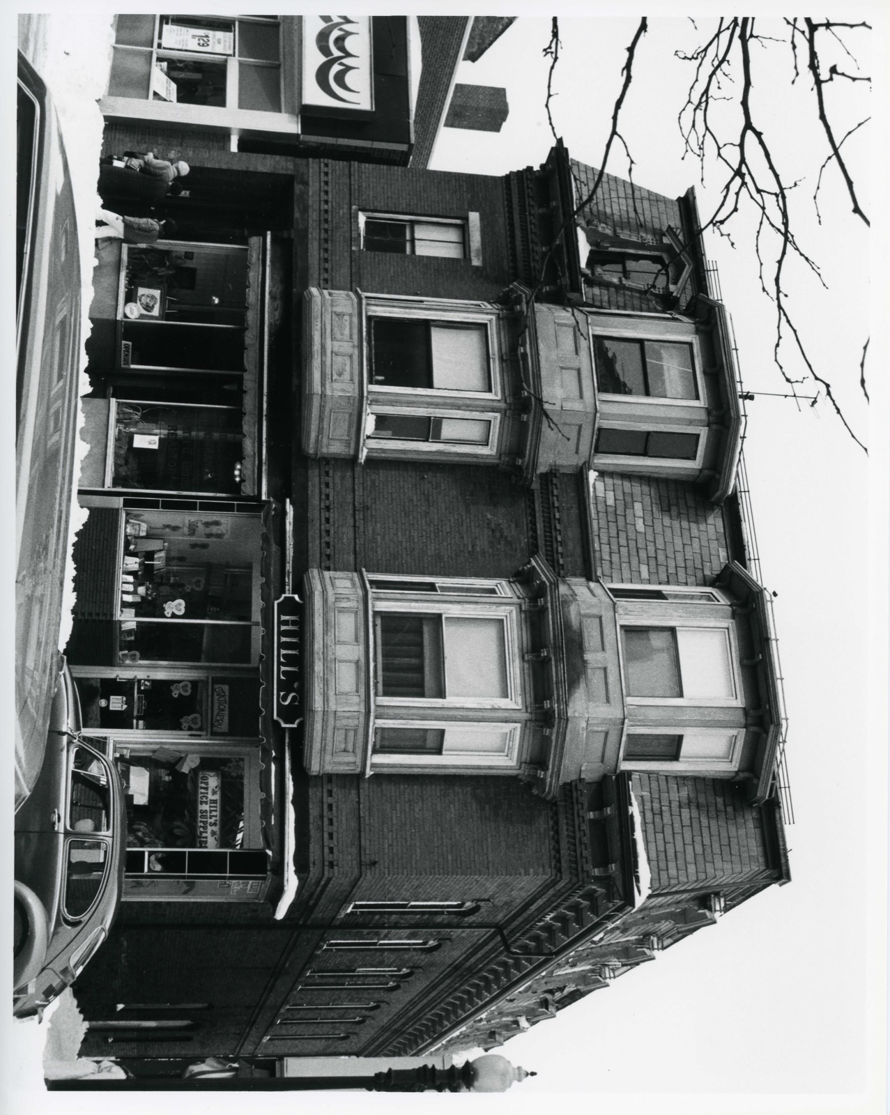
Larrabee's Brick Block is located on a 6115 square foot lot on the west side of Main Street in Melrose's commercial business district. The structure is free-standing and abuts the sidewalk on its east side, a narrow passageway on the north, a small fenced in yard on the west and a one-story early twentieth century building on the south. Other buildings in the 1mmedlate vicinity include the 18/6 Bigbee-Barrett Block (the only other nistoric mansard- rooted structure in the town center), several two and three-story late nineteenth century masonry blocks, anda variety of altered and one-story early mid-twentieth century commer- cial structures. The town center was designated as a local nistoric district in 1979. The building is rectangular in plan, measuring approximately 35 X 63 feet.
It stands three stories high with a straight mansard roof clad in slate constituting the third story. The walls are faced with brick laid in stretcher bond. The building sits on a granite sill and has a full basement. Decorative treatment, which appéars on the cast (facade) and north elevations, includes a single course of alternating recessed bricks between the first and second stories and, at the cornice, three stepped rows of dentilwork and angled bricks. Scrolled brackets are located beneath the eaves. East elevation (facade): The ground story of the facade has two iron storefronts and, in the soutn bay, a recessed entry leading to the upper stories. A plain iron lintel excends the width of the facade. Each storefront has a recessed center entry flanked by plate glass display windows.
Al though aluminum has replaced the original wooden frames and the apron of the right (north) storefront is now made of brick (ca.
/Architect John Eaton Statement of Significance (in one paragraph) Larrabee's Brick Block possesses integrity of location, design, setting, materials, and workmanship. It is representative of tne small mansard-roofed blocks built in commercial districts following the Civil war, and is architecturally significant in tnis community as one of only two unaltered nineteenth century commercial structures in downtown Melrose. Historical associations are with the building's first owner, a prominent local citizen, and with the development of Melrose's commercial center in the second half of the nineteenth century. The building thus meets criteria A, B, and C, of the National Register.
Until the mid-nineteenth century, Melrose (part of the neighboring town of Malden until 1850) was a sparsely settled agricultural community whose economic base was supplemented by scattered shoe making shops. In 1845, the advent of the Boston & Maine railroad to che community opened the area up to residential suburban development wnich took full ad- vantage of the town's craggy picturesque landscape. The population grew rapidly, increasing almost tenfold in the next twenty-five years. smal1 commercial center emerged along Main Street, consisting of approximately a dozen frame structures, many of which combined shops and living quarters. leveled the west siue of Main Street between Essex and Foster Streets.
stood on the site of the nominated property, was the only salvagable building.c Rebuilt as Unity Hall, it was a two-story frame struçture çontaining a spacjous hall. It was soon apparent, however, that the building was an anomaly as the rest of the block was rebuilt in brick or in larger, more fashionable framestructures, many with mansard roofs. In 1880 Unity Hall was, purchased by John Larrabee.
Quoted from the National Register nomination
for reference 84002729, 11 pages, held by the National Archives in Record
Group 79. See the
catalogue record.
Listed places nearby
6 within 8 miles
Other National Register properties close
enough to walk or drive between, ordered by distance from this one. Both
positions come from the same geocoding pass that matched these properties
to their map sheets.
Listing record. National Park Service National Register of Historic Places, listed-properties dataset, current to 2026-05-22.
Map join. Address geocoded through the United States Census geocoder, then tested against the published boundary of every sheet in the USGS Historical Topographic Map Collection.
How this page is made. Listing fields come from federal records; map-sheet coverage is a labelled coordinate-to-boundary calculation, not a source-field claim.
Wildfire. Short, Karen C. 2022. Spatial wildfire occurrence data for the United States, 1992-2020 [FPA_FOD_20221014]. 6th Edition. Fort Collins, CO: Forest Service Research Data Archive. https://doi.org/10.2737/RDS-2013-0009.6 Collected with United States Government funding and usable without additional permissions or fees.
Specimens. Global Biodiversity Information Facility (GBIF), https://www.gbif.org/. Only records licensed CC0 or CC BY are used. Records licensed CC BY-NC are excluded because this site carries advertising. Images are checked individually and any whose licence is non-commercial, no-derivatives or unreadable is refused.
Mines and quarries. USGS Mineral Resources Data System (MRDS) https://mrdata.usgs.gov/mrds/ A work of the United States government, no copyright under 17 U.S.C. 105.
Storms. NOAA National Centers for Environmental Information, Storm Events Database https://www.ncei.noaa.gov/stormevents/ A work of the United States government, no copyright under 17 U.S.C. 105. Narratives are quoted verbatim from the National Weather Service report and are not edited or summarised.
 Block
Block