Built in 1875. Listed on the National Register of Historic Places in
1985. A historic map-sheet match is not published yet. The record needs a coordinate-quality review before it can be joined to a sheet boundary.
From the record
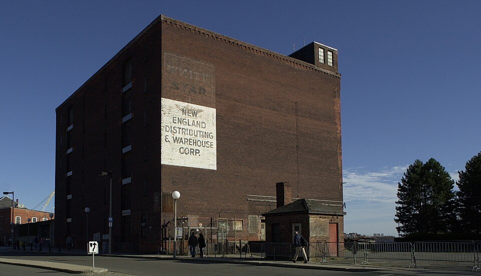
“The Hoosac Stores was a historic warehouse at 115 Constitution Road in Charlestown, Massachusetts and was demolished in 2025. Originally designated Hoosac Stores 1 & 2, it is a six-story load-bearing brick warehouse, set just outside the gate of the Boston Navy Yard.”
Wikipedia article Hoosac Stores, CC BY-SA 4.0.
one of 206 National Register listings in Suffolk County · listed in 1985 · category: District · built in 1875 · one of 5 National Historic Landmarks in Suffolk County.
National Register reference number.85002339- the number the National Park Service assigned this property when it was listed, and the key its nomination file is catalogued under at the National Archives.
What happened here
An account from the chapter on Boston city, The inset identifies its exact
source book and publication year.
IN giving some notices of manners and social life during this period, I shall speak first of usages which were characteristic of the close of the last century: most of them continued without essential modification until our city charter swept away the old landmarks, and Boston felt the im¬ pulses which mark a new epoch in her history.
It is unpleasant to add anything to this gracious record of the occasion, but it is nevertheless ascertainable that the banquet terminated in an uproar ; that pieces of the ox were thrown into the air, and were even directed towards those bevies of beautiful women whom the reporter had beheld so lavish of their smiles. While the multitude were feeding or riot¬ ing in State Street, a select minority of the friends of Equality, to the number of nearly four hundred, partook of a more elaborate dinner in Faneuil Hall. Here Citizen S. Adams acted as president, and Citizen Waters furnished the decorations. Among the devices of this latter gentleman appeared an obelisk bearing in front a figure of Liberty trampling upon crown, sceptre, mitre, and broken chains, a cherub holding wreaths and palms with appro¬ priate inscriptions, and above all "the benign eye of Providence" contem¬ plating with satisfaction the proceedings below. In the course of the commemoration a committee from Charlestown was introduced to announce that the citizens of that place would drink the health of the citizens of Boston at four o'clock, " whereupon it was voted that the citizens of Boston should return this compliment at a quarter past four, under a discharge of artillery." For why should not the heavens bruit again the rouse of demo¬ crats as well as that of royalty? The descendants of the Puritans seem to
Boston has grown in area not only by reclaiming land from the sea, but by absorbing neighboring territory, - first, by the annexation of parts of the domain of adjoining municipalities ; and latterly, by taking the whole, - extinguishing the separate municipal existence of the cities and towns absorbed. In this way South Boston (or Dorchester Neck as it was then called), Washington Village, Roxbury, Dorchester, Charlestown, Brighton,
Regional context, not property-specific
evidence. The
federal wildfire occurrence database
lists 46 fires within 5 miles of Hoosac Stores 1 & 2-Hoosac Stores 3 between
2015 and 2020, burning about 24 acres in total. None started naturally. 2 were recorded as arson.
Distance is straight-line from the map coordinates, so a fire counted
here may appear on a neighbouring settlement's page as well.
Reported cause
Fires
Missing data/not specified/undetermined
18
Debris and open burning
11
Recreation and ceremony
7
Smoking
6
Arson/incendiarism
2
Equipment and vehicle use
1
Misuse of fire by a minor
1
The most recent of
them, most recent first, with the day each was reported and the service
that recorded it.
Regional context, not property-specific
evidence. Museums hold 17,882 specimens
collected within 10 miles of Hoosac Stores 1 & 2-Hoosac Stores 3 between 1810 and
1975: 8,154 Plantae, 4,262 Fungi, 3,658 Animalia, 1,277 Chromista, 229 Bacteria, 185 Protozoa, 117 Unrecorded. 12 distinct Species records are shown.
Collected by ?, A B Seymour, A C Gibson and others. Each is a
physical object with a catalogue
number, and each entry opens the museum's record. This is what was
collected and kept, not a survey of what lives here - nothing can be
concluded from a species being absent.
Regional context, not property-specific
evidence. The federal mineral resources record lists
13 workings within 5 miles of Hoosac Stores 1 & 2-Hoosac Stores 3: 9 plants, 2 past producers, 1 unknown, 1 producer.
10 still produce. What was taken out: Iron, Lead, Stone, Crushed/Broken, Gypsum-Anhydrite. Distance is straight-line from the
map coordinates, so a quarry counted here may appear on a neighbouring
settlement's page as well.
Regional context, not property-specific
evidence. The National Weather Service names
Charlestown, the town this property stands in, in 7 storm reports between 2010 and 2022: 4 thunderstorm wind, 2 flood, 1 hail.
No death or injury is recorded in these reports. Each account below is quoted exactly as the forecast office
filed it, from the NOAA Storm Events Database, and each date
opens the federal record of that event.
Heavy rains resulted in flooding across much of Boston. This flooding resulted in damage to the collections at both the Bostonian Society and the Massachusetts Historical Society. In addition, several roads in Dorchester and Revere were closed. A portion of the MBTA Green line was closed between Fenway Park and Kenmore for several hours on Monday due to a flooded tunnel. A portion of the MBTA Red line was closed between Ashmont and Fields Corner because of flooded tracks. Passengers were transported by bus.
At 6:30 AM EST, Storrow Drive near U.S. Route 1 was flooded and impassable, with a car trapped in the floodwaters. At 6:33 AM EST, Storrow Drive was also flooded and impassable in the Lagoon area along the Back Bay; cars were driving across the median to avoid the flooding. At 6:40 AM a car was trapped in floodwaters under the Massachusetts Avenue bridge. At 6:49 AM Heath Street was flooded and impassable.
No historic map-sheet match is published
for this property yet. That does not mean no map exists. This record needs
a coordinate-quality review before it can be joined to a sheet boundary.
Browse the county's mapped places while that work is
pending.
From the nomination file
6,850 words on record
When this property was proposed for the
National Register, someone wrote the case for it: what the building is,
and why it matters. That document is a federal record in the public domain.
It is quoted below word for word, never summarised. The text was read off the scanned case file by machine, so the
occasional stray character is the recogniser's and the 1970s
typewriter's.
Description of the property
Hoosac Stores 1 & 2, 115 Water Street (1895) Hoosac Stores 1 & 2, built in 1895, is a six-story warehouse structure of red brick laid in common bond. The building is intact with some evolutionary changes. It is trapezoidal in shape, constrained by the shape of the lot which it entirely occupies. The north/street (112'0") and south/harbor (151'1½") walls are parallel, while the east wall (ca. 91' 10½") diagonally follows the boundary with the Navy Yard. The west wall (83' 1½") is perpendicular to the north and south walls. The storehouse is approximately sixty-five feet in height and has no basement. Constructed on filled land, it has a foundation of wooden piles and granite.
The external walls are load bearing and are about twenty-four inches thick on the ground floor, becoming progressively thinner on the upper floors. Internal construction is heavy timber, mill-type with main beams of steel supported on posts. These are of round section cast iron on the first and second floors and of timber on the third through sixth Iloors. Secondary timber beams are 12 by 15 inches on the first and second floors and 10 by 12 inches on the floors above. A brick fire wall divides the interior of Hoosac Stores 1 & 2 into two equal areas. Each of the six floors is approximately 80by 125 feet or 10,000 square feet. Height of the sixth is 9 feet 4 inches, measuring from floor to underside of roof beam.
The first story of the warehouse has a concrete floor while upper floors are of wood. In addition to two freight elevators, there is an enclosed stairway giving access to each floor. (redete doo a anged ned beck corice and the dtch fioor 1odtnd doors are topped by brick segmental arches.
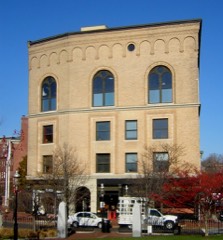
/ARCHITECT Fitchburg Railroad Hoosac Stores 1 & 2 and Hoosac Stores 3 are significant both architecturally and by association with the historical period which produced them. A substantial brick structure, Hoosac Stores 1 & 2 was designed specifically to serve as a storehouse, and, with its austere facades and utilitarian slit windows, it is useful for that purpose only. Hoosac Stores 3, converted into a warehouse, is an industrial building with a well designed exterior. Both structures, as warehouses, stand as a particular type of historic evidence to America's industrial revolution. Hoosac Stores 3 is also the only surviving evidence of the machine shop and boiler making industry important to Charlestown in the late nineteenth century.
Hoosac Stores 1 & 2, with its vertical construction and its trapezoidal shape, reflects both the need for storage space and the limited land available for that purpose in an already developed urban setting. Hoosac Stores 3 exemplifies the classically inspired paneled brick style popular for industrial buildings of the later nineteenth and early twentieth centuries. Characteristic of this style are the paired segmentally arched windows set into recessed, arched panels which rise the height of the building and are defined by brick pilasters. With the general decline of the port of the Boston, many warehouses have been taken down and the Hoosac Stores are probably two of a few surviving structures of their type along the waterfront of Boston.
Hoosac Stores 1 & 2, Hoosac Stores 3, and the railroad right-of-way between them define the location of a once thriving nineteenth and early twentieth century complex of docks, wharves, grain elevator, warehouses, and related structures.
Quoted from the National Register nomination
for reference 85002339, 32 pages, held by the National Archives in Record
Group 79. See the
catalogue record.
Listed places nearby
6 within 8 miles
Other National Register properties close
enough to walk or drive between, ordered by distance from this one. Both
positions come from the same geocoding pass that matched these properties
to their map sheets.
Listing record. National Park Service National Register of Historic Places, listed-properties dataset, current to 2026-05-22.
Map join. Address geocoded through the United States Census geocoder, then tested against the published boundary of every sheet in the USGS Historical Topographic Map Collection.
How this page is made. Listing fields come from federal records; map-sheet coverage is a labelled coordinate-to-boundary calculation, not a source-field claim.
Wildfire. Short, Karen C. 2022. Spatial wildfire occurrence data for the United States, 1992-2020 [FPA_FOD_20221014]. 6th Edition. Fort Collins, CO: Forest Service Research Data Archive. https://doi.org/10.2737/RDS-2013-0009.6 Collected with United States Government funding and usable without additional permissions or fees.
Specimens. Global Biodiversity Information Facility (GBIF), https://www.gbif.org/. Only records licensed CC0 or CC BY are used. Records licensed CC BY-NC are excluded because this site carries advertising. Images are checked individually and any whose licence is non-commercial, no-derivatives or unreadable is refused.
Mines and quarries. USGS Mineral Resources Data System (MRDS) https://mrdata.usgs.gov/mrds/ A work of the United States government, no copyright under 17 U.S.C. 105.
Storms. NOAA National Centers for Environmental Information, Storm Events Database https://www.ncei.noaa.gov/stormevents/ A work of the United States government, no copyright under 17 U.S.C. 105. Narratives are quoted verbatim from the National Weather Service report and are not edited or summarised.
 Block
Block