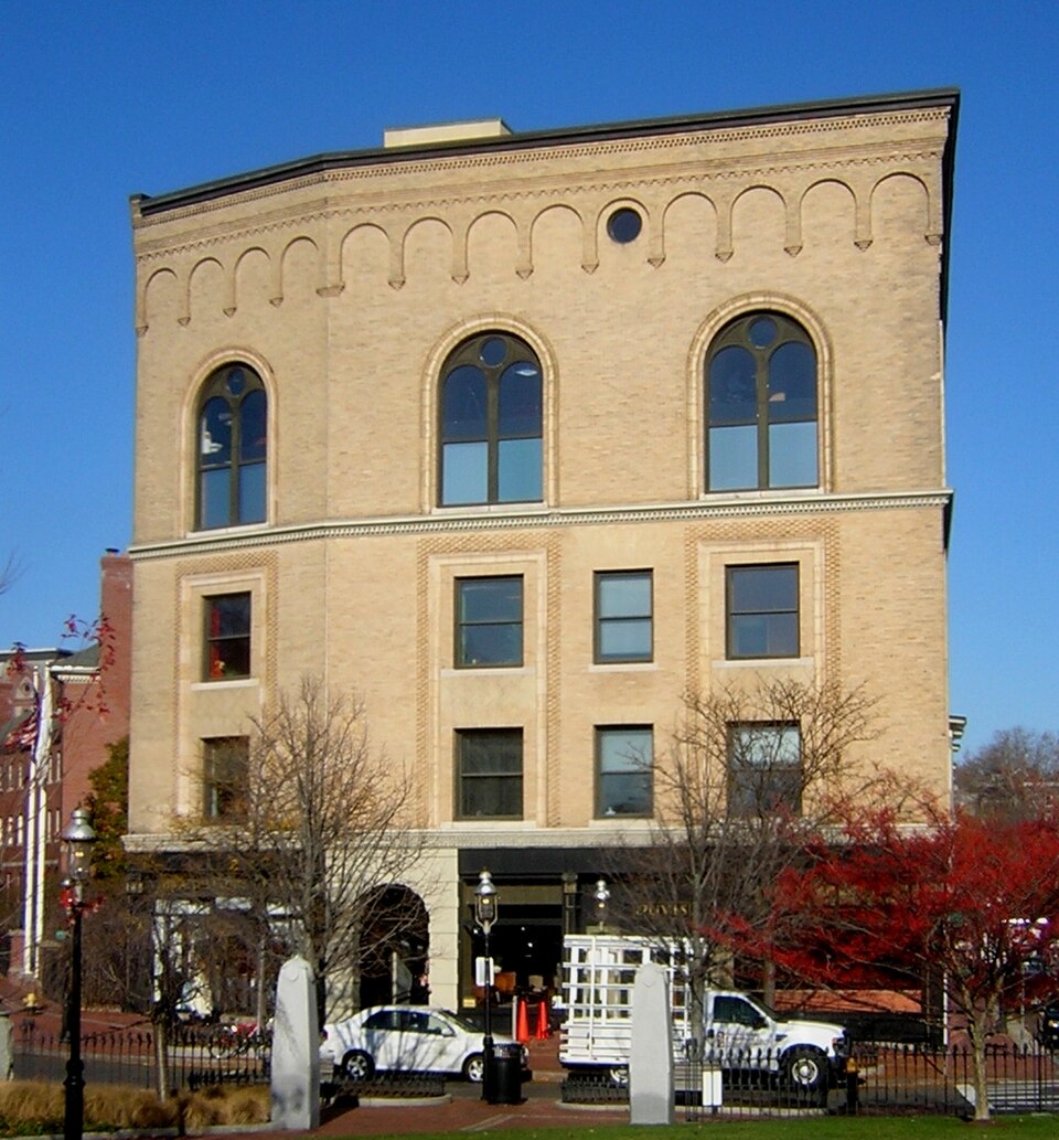
Built in 1892 in the Romanesque Revival architecture. Listed on the National Register of Historic Places in
1982. A historic map-sheet match is not published yet. The record needs a coordinate-quality review before it can be joined to a sheet boundary.
From the record
“Roughan Hall is a historic commercial building at 10 City Square, the historic central square of the Charlestown neighborhood of Boston, Massachusetts. Built in 1892 and enlarged in 1896, it is the square's only surviving 19th-century commercial building, and a distinctive example of Romanesque and Renaissance Revival architecture.”
Wikipedia article Roughan Hall, CC BY-SA 4.0.
one of 206 National Register listings in Suffolk County · listed in 1982 · category: Building · built in 1892, Romanesque Revival architecture · one of 5 National Historic Landmarks in Suffolk County.
National Register reference number.82004448- the number the National Park Service assigned this property when it was listed, and the key its nomination file is catalogued under at the National Archives.
What happened here
An account from the chapter on Boston city, The inset identifies its exact
source book and publication year.
IN giving some notices of manners and social life during this period, I shall speak first of usages which were characteristic of the close of the last century: most of them continued without essential modification until our city charter swept away the old landmarks, and Boston felt the im¬ pulses which mark a new epoch in her history.
Illustrations: State House and the Monument (in 1811), 64; the Monument from the corner of Temple and Derne streets, 65 ; the Monument and the Thurston House, 65; Beacon Street and the Common (in 1804-1811), heliotype, 65; Boston from Breed's Hill (in 1791), 66; the Faneuil-Phillips House,
IN giving some notices of manners and social life during this period, I shall speak first of usages which were characteristic of the close of the last century: most of them continued without essential modification until our city charter swept away the old landmarks, and Boston felt the im¬ pulses which mark a new epoch in her history. It is difficult to deal justly with ways of living which are not widely different from those that surround us. We miss the salient contrasts which lend themselves to picturesque de¬ scription, and are tempted to look for exceptional occurrences to brighten a narrative, rather than for facts which are truly symptomatic of taste and thought. Were it possible to go back four-score years, or even a century, and mingle with those then conducting the town, we should not feel among strangers. In many respects their ways were counterparts of our own. In certain directions, indeed, we might note a narrowness of range and a contraction of outlook, while envying the vigor of speech and de¬ cisiveness of action which seemed the outcome of the limitations. When Massachusetts took her place in the sisterhood of States, the gigantic up¬ heaval of the French Revolution had not taken place. The prophets whom her capital was to raise up to demand the redemption of human society, each with his panacea for its sad ailments, had put in no appearance. The tyranny of England had been broken by an heroic effort, and any further redemption which society might need would be provided by those who VOL. iv. - i.
Regional context, not property-specific
evidence. The
federal wildfire occurrence database
lists 45 fires within 5 miles of Roughan Hall between
2015 and 2020, burning about 23 acres in total. None started naturally. 2 were recorded as arson.
Distance is straight-line from the map coordinates, so a fire counted
here may appear on a neighbouring settlement's page as well.
Reported cause
Fires
Missing data/not specified/undetermined
17
Debris and open burning
11
Recreation and ceremony
7
Smoking
6
Arson/incendiarism
2
Equipment and vehicle use
1
Misuse of fire by a minor
1
The most recent of
them, most recent first, with the day each was reported and the service
that recorded it.
Regional context, not property-specific
evidence. Museums hold 17,888 specimens
collected within 10 miles of Roughan Hall between 1810 and
1975: 8,155 Plantae, 4,262 Fungi, 3,663 Animalia, 1,277 Chromista, 229 Bacteria, 185 Protozoa, 117 Unrecorded. 12 distinct Species records are shown.
Collected by ?, A B Seymour, A C Gibson and others. Each is a
physical object with a catalogue
number, and each entry opens the museum's record. This is what was
collected and kept, not a survey of what lives here - nothing can be
concluded from a species being absent.
Regional context, not property-specific
evidence. The federal mineral resources record lists
13 workings within 5 miles of Roughan Hall: 9 plants, 2 past producers, 1 unknown, 1 producer.
10 still produce. What was taken out: Iron, Lead, Stone, Crushed/Broken, Gypsum-Anhydrite. Distance is straight-line from the
map coordinates, so a quarry counted here may appear on a neighbouring
settlement's page as well.
Regional context, not property-specific
evidence. The National Weather Service names
Boston, the town this property stands in, in 64 storm reports between 1994 and 2024: 37 thunderstorm wind, 9 flash flood, 7 lightning, 7 flood.
The reports record 1 death and 9 injuries. Each account below is quoted exactly as the forecast office
filed it, from the NOAA Storm Events Database, and each date
opens the federal record of that event.
A 50 year old man was struck by lightning while walking in an area known as the Sugar Bowl in South Boston. Lightning struck him in the head, passing through his back and exiting his feet. He collapsed in cardiac arrest and was revived and hospitalized for several days before dying from his injuries.
A 29 year old male and a 29 year old female were knocked unconscious when lightning struck them at Thomas Park, where the pair were watching the July 4th fireworks. They regained consciousness prior to the arrival of EMTs, but unable to feel their legs and were transported to Brigham and Women's Hospital.
In Boston, two cars were stuck in flood waters on Corey Road. Storrow Drive was closed due to flooding at the Mass Avenue and Longmeadow Bridges. Several other roadways in the city experienced significant flooding.
Numerous trees and wires and several utility poles were downed throughout Boston, including in Boston Common. Several trees were downed onto cars throughout town, though no injuries resulted. One tree was downed onto a building on Corey Road. The Automated Surface Observing System at Logan International Airport in Boston, MA (KBOS) recorded sustained wind speeds of 47 mph and wind gusts up to 68 mph.
Multiple trees and wires were downed throughout Boston, including on Barstow Street, Forrester Street, Washington Street, Houston Road, and Keith Street. Trees were downed onto cars on Forrester and Washington Streets. A portion of a chimney was blown over onto Keith Street.
The National Weather Service at Logan International Airport recorded a wind gust to 60 mph as a severe thunderstorm moved across the city of Boston. Scaffolding was blown down at government center and some large trees were blown down in Revere and Winthrop. One damaged a house in Winthrop and a tree limb and electrical wires fell onto an auto. The occupants of the auto were not injured.
At 546 PM EST, an amateur radio operator reported two trees down on Belden Street in the Upham's Corner section of Boston. Also, two trees were down on Hamlet Street including one down on three cars. A tree was down on Willis Street. A tree was down on wires on Taft Street.
At 3:26 PM EST, heavy rain caused the intersection of Lewis and Marginal Streets in East Boston to be flooded and impassable. At 3:36 PM EST a car was trapped in floodwaters at Clark and Stockton Streets in Chelsea. At 3:38 PM EST several cars were trapped in floodwaters on the McClellan Highway, Condor Street and Putnam Street in East Boston.
At 5:05 PM EST several cars on Child Street and Boynton Street were trapped in flood waters as high as the car doors. At 5:10 PM EST a car was trapped in flooding on Columbia Road at Bodwell Street, and Ceylon Street was impassable at Quincy Street due to flooding.
A tree was downed by thunderstorm winds onto a car at the intersection of Bakersfield and Stoughton Streets. Another tree was downed onto a car on Columbia Road.
8 papers published in this town,
digitised by the Library of Congress and free to read: 0 issues,
0 pages. Every page is searchable, so a name or a street can be
looked for directly in what the town printed about itself at the time.
No historic map-sheet match is published
for this property yet. That does not mean no map exists. This record needs
a coordinate-quality review before it can be joined to a sheet boundary.
Browse the county's mapped places while that work is
pending.
From the nomination file
2,521 words on record
When this property was proposed for the
National Register, someone wrote the case for it: what the building is,
and why it matters. That document is a federal record in the public domain.
It is quoted below word for word, never summarised. The text was read off the scanned case file by machine, so the
occasional stray character is the recogniser's and the 1970s
typewriter's.
Description of the property
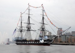
Roughan Hall is located in City Square, the gateway to Charlestown from Boston Proper:. It is across Main Street from the Town Hill Historic District (NR-1970), and is a short distance from the Charlestown Navy Yard, home of the USS Constitution (NR-1966). The area surrounding the building is characterized by mixed residential, commercial, municipal, and institutional use and the Highway Interchange system of Interstates 93 and 95. Roughan Hall is a four-story, plus truss-level, flat-roofed masonry structure, built in two stages in 1892 and 1896. It is built of New Jersey buff brick and its design shows Renaissance Revival and Romanesque Revival influences. The two dressed facades border on City Square and Park Street.
The building's irregular plan re- flects site boundaries: seventy-five feet on City Square, one hundred and seventeen feet on Park Street and forty-six feet on Roughans Way (the alley). Its seventy- two foot height and imposingly formal and monumental appearance make it the key structure in City Square. It is the only remaining 19th centüry building in the Square. Five bays wide, the Park Street facade remains basically unaltered and symmetrical. Molded string courses of limestone above the first and third floors divide the facade according to function-ground floor shops, second and third story offices, and fourth story hall. a vertical emphasis and are regu- larly spaced.
and third floor windows, with splayed brick lintels, are al- ternately articulated with two-story flat-arched tan terra cotta and patterned brick surrounds. These are surmounted on the fourth floor by tall round arches with terra cotta surrounds enclosing windows divided by heavy wooden tracery into two arched lights and an oculus. A rather flat corbelled cornice is supported by a round- arched arcaded corbel table, with an oculus set in each fourth arch.
/Architect Arthur H. Vinal, Architect Donovan & Brock, Builders Statement of Significance (in one paragraph) Roughan Hall possesses integrity of location, design, setting, materials, and workmanship and is an outstanding example of mixed-use, (retail, conmercial and private halls) building design in the Boston area. Built in 1892, with an 1896 addition, it is a fine example of late Italiar Renaissance revival vernacular conmercial architecture. It is one of the few remaining 19th cen- tury "Halls" in Boston, and the only remaining 19th century building fronting on City Square. For these reasons, the building meets criterion C. Roughan Hall was designed by Arthur H.
Vinal, and constructed by the firm of Donovan and Brock for Michael Roughan, a prominent businessman and philanthropist in Charlestown. Arthur H. Vinal (1855-1923), who was the municipal architect for the city of Boston in the 1890's, began his career with the widely-known architectural firm of Peabody and Stearns, and in his early twenties started his own practice in Pemberton Square. institution- al, and residential commissionsin Boston and the New England area. for the Lodge at the base of the Bunker Hill Monument, (NR-1966), the Robert B. Brigham Hospital, the Fire Station (1884), and the Police Station (1884 on Boylston near Hereford (now the Institute of Con- temporary Art) Back Bay District (NR-1973), and the Opera Houses at Bangor and Augusta, Maine.
City Square, known as the "Market Place" in 1640, was Charlestown's original conmercial center. By 1892, it was the site of the Courthouse, the Town Hall, several banks, and a hotel, as well as numerous: shops. When Roughan Hall first opened, storefronts lined Park and Main Streets and all There were originally four street level stores in Roughan Hall; the City Square occupants were the Charlestown Real Estate Agency and D. J. Griffin-Hatter.
Quoted from the National Register nomination
for reference 82004448, 16 pages, held by the National Archives in Record
Group 79. See the
catalogue record.
Listed places nearby
6 within 8 miles
Other National Register properties close
enough to walk or drive between, ordered by distance from this one. Both
positions come from the same geocoding pass that matched these properties
to their map sheets.
Listing record. National Park Service National Register of Historic Places, listed-properties dataset, current to 2026-05-22.
Map join. Address geocoded through the United States Census geocoder, then tested against the published boundary of every sheet in the USGS Historical Topographic Map Collection.
How this page is made. Listing fields come from federal records; map-sheet coverage is a labelled coordinate-to-boundary calculation, not a source-field claim.
Wildfire. Short, Karen C. 2022. Spatial wildfire occurrence data for the United States, 1992-2020 [FPA_FOD_20221014]. 6th Edition. Fort Collins, CO: Forest Service Research Data Archive. https://doi.org/10.2737/RDS-2013-0009.6 Collected with United States Government funding and usable without additional permissions or fees.
Specimens. Global Biodiversity Information Facility (GBIF), https://www.gbif.org/. Only records licensed CC0 or CC BY are used. Records licensed CC BY-NC are excluded because this site carries advertising. Images are checked individually and any whose licence is non-commercial, no-derivatives or unreadable is refused.
Mines and quarries. USGS Mineral Resources Data System (MRDS) https://mrdata.usgs.gov/mrds/ A work of the United States government, no copyright under 17 U.S.C. 105.
Storms. NOAA National Centers for Environmental Information, Storm Events Database https://www.ncei.noaa.gov/stormevents/ A work of the United States government, no copyright under 17 U.S.C. 105. Narratives are quoted verbatim from the National Weather Service report and are not edited or summarised.
 Block
Block