Listed on the National Register of Historic Places in
1986. A historic map-sheet match is not published yet. The record needs a coordinate-quality review before it can be joined to a sheet boundary.
From the record
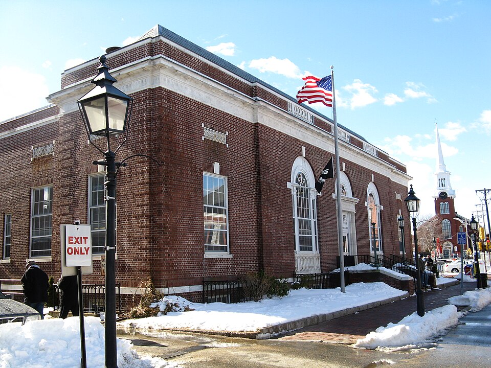
“The US Post Office - Newburyport Main is a historic post office in Newburyport, Massachusetts. Construction of the Georgian Revival single story brick building was begun in 1927 and completed in 1928.”
Wikipedia article United States Post Office-Newburyport Main, CC BY-SA 4.0.
one of 350 National Register listings in Essex County · listed in 1986 · category: Building · one of 2 National Historic Landmarks in Essex County.
National Register reference number.86001341- the number the National Park Service assigned this property when it was listed, and the key its nomination file is catalogued under at the National Archives.
Fires near this property
62 since 2015
Regional context, not property-specific
evidence. The
federal wildfire occurrence database
lists 62 fires within 5 miles of US Post Office--Newburyport Main between
2015 and 2020, burning about 91 acres in total. None started naturally. 26 were recorded as arson.
Distance is straight-line from the map coordinates, so a fire counted
here may appear on a neighbouring settlement's page as well.
Reported cause
Fires
Arson/incendiarism
26
Missing data/not specified/undetermined
15
Debris and open burning
12
Recreation and ceremony
5
Smoking
3
Misuse of fire by a minor
1
The most recent of
them, most recent first, with the day each was reported and the service
that recorded it.
Regional context, not property-specific
evidence. Museums hold 11,233 specimens
collected within 10 miles of US Post Office--Newburyport Main between 1803 and
1975: 5,264 Plantae, 2,489 Animalia, 2,159 Fungi, 926 Chromista, 280 Bacteria, 66 Unrecorded, 49 Protozoa. 12 distinct Species records are shown.
Collected by ?, A B. Proper, A. A. Eaton and others. Each is a
physical object with a catalogue
number, and each entry opens the museum's record. This is what was
collected and kept, not a survey of what lives here - nothing can be
concluded from a species being absent.
Regional context, not property-specific
evidence. The federal mineral resources record lists
3 workings within 5 miles of US Post Office--Newburyport Main: 2 plants, 1 producer.
All of them still produce. What was taken out: Copper, Lead, Silica, Stone, Crushed/Broken. Distance is straight-line from the
map coordinates, so a quarry counted here may appear on a neighbouring
settlement's page as well.
Regional context, not property-specific
evidence. The National Weather Service names
Newburyport, the town this property stands in, in 13 storm reports between 1997 and 2023: 8 thunderstorm wind, 3 hail, 1 heavy rain, 1 lightning.
No death or injury is recorded in these reports. Each account below is quoted exactly as the forecast office
filed it, from the NOAA Storm Events Database, and each date
opens the federal record of that event.
The Weatherflow reporting station at Plum Island recorded a wind gust of 69 mph. Wires were downed onto Sunset Drive in Newburyport from these thunderstorm winds.
1 paper published in this town,
digitised by the Library of Congress and free to read: 0 issues,
0 pages. Every page is searchable, so a name or a street can be
looked for directly in what the town printed about itself at the time.
No historic map-sheet match is published
for this property yet. That does not mean no map exists. This record needs
a coordinate-quality review before it can be joined to a sheet boundary.
Browse the county's mapped places while that work is
pending.
From the nomination file
2,751 words on record
When this property was proposed for the
National Register, someone wrote the case for it: what the building is,
and why it matters. That document is a federal record in the public domain.
It is quoted below word for word, never summarised. The text was read off the scanned case file by machine, so the
occasional stray character is the recogniser's and the 1970s
typewriter's.
Description of the property
DATE_ _LOCAL CONTEXT_ Within Newburyport's downtown historic district, the Newburyport Post Office is located at one of the city's main intersections, Pleasant and Green Streets. Adjacent are business offices, storefront retail, two churches (a Baptist Church to the west and the Church of the First Religious Society to the east), Brown Square Park, and Newburyport City Hall (built in 1851 in an Italian Villa style with rusticated quoins, gable roof, and round-headed pediment windows). A new brick sidewalk has been laid throughout the area. _PHYSICAL APPEARANCE_ Overall, the building and corner lot are in good condition.
Its distinctive features include three large arched, marble-trimmed openings with a Palladian motif, symmetrical floorplan and elevation, a hip roof, brick quoins, and a marble belt course and cornice line. The structure is on the front portion of the site, with a paved vehicle maneuvering area occupying most of the east side and all of the back of the property. In plan the building has an original vestibule that leads to a public lobby flanked by the Postmaster's office to the right and service area to the left. Behind theservice screen is theworkroom with mail vestibule and platform beyond. Seven granite steps with brass pipe railings create the main approach. Low wing walls, brick with a marble cap, frame the stairs; on top are cast iron lampposts.
The front (north) elevation is a five-bay structure with a three-bay central projecting entrance. The elevations are of red brick laid in an English bond with corner quoins reminiscent of the adjacent City Hall. The windows are double-hung wood sash, 12/12 lights with marble sills and keystones.
Arnold Shorrick, Architects Repairs: 1975 The Newburyport Main Post Office building is situated in the heart of Newburyport's historic downtown. Built in 1928 it was designed in the Colonial or more specifically, Georgian Revival style. Architecturally it is significant as an example of the U.S. Treasury Department's policy during the 1910's and 1920's to erect "buildings adapted to local conditions and in keeping with the importance of the communities in which they are erected." Compatibility, interiors forms, style and materials with surrounding structures is the Newburyport Post Office building's chief hallmark. The monumentality, expensive building materials and lavish interior treatments, typical of the early 1900's post office design, is no where in evidence.
Its boxey red brick with stone trimmed form complememts the red brick Italianate City Hall (1851) and other buildings in the immediate area. During the mid 1970's, Newburyport was one of 799 towns and cities determined eligible for a Federal building by a U. S. Treasury Department survey. The Newburyport Post Office building owes its existence to the Public Buildings Act of 1926 - a general enabling act which allotted $100,000.00 for buildings outside the District of Columbia. The building falls within Class C of the Secretary of the Treasury's 1915 Classification of Buildings by virtue of its location within a "second class city" and the type of materials employed in its construction. This building!'s.U.S, Treasury Supervising Architect was James A.
Wetmore - born November 10, 1863 in Bath, New York, he was a graduate of Georgetown University. He began work as a law and court stenographer and joined the U.S. Treasury Department in 1885. Over a 45 year period, he held positions within the U.S. Treasury Department ranging from stenographer to Supervising Architect. During his tenure at least 2,000 buildings were designed in his office.
Quoted from the National Register nomination
for reference 86001341, 19 pages, held by the National Archives in Record
Group 79. See the
catalogue record.
Listed places nearby
3 within 8 miles
Other National Register properties close
enough to walk or drive between, ordered by distance from this one. Both
positions come from the same geocoding pass that matched these properties
to their map sheets.
Listing record. National Park Service National Register of Historic Places, listed-properties dataset, current to 2026-05-22.
Map join. Address geocoded through the United States Census geocoder, then tested against the published boundary of every sheet in the USGS Historical Topographic Map Collection.
How this page is made. Listing fields come from federal records; map-sheet coverage is a labelled coordinate-to-boundary calculation, not a source-field claim.
Wildfire. Short, Karen C. 2022. Spatial wildfire occurrence data for the United States, 1992-2020 [FPA_FOD_20221014]. 6th Edition. Fort Collins, CO: Forest Service Research Data Archive. https://doi.org/10.2737/RDS-2013-0009.6 Collected with United States Government funding and usable without additional permissions or fees.
Specimens. Global Biodiversity Information Facility (GBIF), https://www.gbif.org/. Only records licensed CC0 or CC BY are used. Records licensed CC BY-NC are excluded because this site carries advertising. Images are checked individually and any whose licence is non-commercial, no-derivatives or unreadable is refused.
Mines and quarries. USGS Mineral Resources Data System (MRDS) https://mrdata.usgs.gov/mrds/ A work of the United States government, no copyright under 17 U.S.C. 105.
Storms. NOAA National Centers for Environmental Information, Storm Events Database https://www.ncei.noaa.gov/stormevents/ A work of the United States government, no copyright under 17 U.S.C. 105. Narratives are quoted verbatim from the National Weather Service report and are not edited or summarised.
 Block
Block