BlockBefore
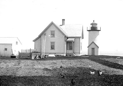
Photograph of Tarpaulin Cove Light
Photograph by US Coast Guard, Public domain. Via Wikimedia Commons.

Tarpaulin Cove Light

Built in 1818. Listed on the National Register of Historic Places in 1987. A historic map-sheet match is not published yet. The record needs a coordinate-quality review before it can be joined to a sheet boundary.

From the record

“The Tarpaulin Cove Light is a historic lighthouse on Naushon Island, one of the Elizabeth Islands of southern Massachusetts. It is located in the town of Gosnold, Massachusetts.”

Wikipedia article Tarpaulin Cove Light, CC BY-SA 4.0.

one of 11 National Register listings in Dukes County · listed in 1987 · category: Structure · built in 1818 · one of 1 National Historic Landmarks in Dukes County.

Sources: the Wikipedia article · the case file at the National Archives · the National Register database, National Park Service
The listing

  • What is counted as historic. The nomination lists 1 structure as contributing to the listing.
  • Address. Naushon Island, Gosnold, 02543
  • When was it listed? 1987-06-15
  • Category. structure
  • Also known as. Lighthouses of Massachusetts TR
  • Township. Gosnold town
  • When was it built? 1818
  • National Register reference number. 87001505 - the number the National Park Service assigned this property when it was listed, and the key its nomination file is catalogued under at the National Archives.

Fires near this property

1 since 2020

Regional context, not property-specific evidence. The federal wildfire occurrence database lists 1 fire within 5 miles of Tarpaulin Cove Light between 2020 and 2020, burning about 0 acres in total. None started naturally. None was recorded as arson. Distance is straight-line from the map coordinates, so a fire counted here may appear on a neighbouring settlement's page as well.

Reported cause Fires
Missing data/not specified/undetermined1

The most recent of them, most recent first, with the day each was reported and the service that recorded it.

DateCause SizeReported by Name on the report
27 July 2020Missing data/not specified/undeterminedunder an acreMassachusetts Bureau of Forest Fire Controlnot named

Every fire recorded in Dukes County

Specimens collected near this property

12 of 18,748 shown

Regional context, not property-specific evidence. Museums hold 18,748 specimens collected within 10 miles of Tarpaulin Cove Light between 1828 and 1975: 11,808 Animalia, 4,545 Plantae, 1,203 Chromista, 796 Fungi, 174 Unrecorded, 173 Bacteria, 49 Protozoa. 12 distinct Species records are shown. Collected by A AND P STARRETT, A B Seymour, A. and others. Each is a physical object with a catalogue number, and each entry opens the museum's record. This is what was collected and kept, not a survey of what lives here - nothing can be concluded from a species being absent.

Image SpeciesYear Collected by Where, as recorded
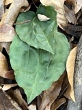
A photograph of the species Tipularia discolor, not of this specimenTipularia discolor (Pursh) Nutt.1828OakesMartha's Vineyard
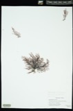
A photograph of the species Polysiphonia flexicaulis, not of this specimenPolysiphonia flexicaulis (Harvey) F.S.Collins1839unknownWoods Hole
A photograph of the species Ectocarpus littoralis, not of this specimenEctocarpus littoralis (L.) Lyngb.1841B. F. D. RunkWoods Hole, Nobska Point, wash
A photograph of the species Polysiphonia fibrata, not of this specimenPolysiphonia fibrata (Dillwyn) Harvey1844Collector unknown
A photograph of the species Alosa aestivalis, not of this specimenAlosa aestivalis (Mitchill, 1814)1852not recordedWood's Hole, Massachusetts.
A photograph of the species Clupea harengus, not of this specimenClupea harengus Linnaeus, 17581852not recordedWood's Hole, Massachusetts.
A photograph of the species Menidia menidia, not of this specimenMenidia menidia (Linnaeus, 1766)1852not recordedWood's Hole, Massachusetts.
A photograph of the species Prionotus evolans, not of this specimenPrionotus evolans (Linnaeus, 1766)1852not recordedWood's Hole, Massachusetts.
A photograph of the species Ulva clathrata, not of this specimenUlva clathrata (Roth) C.Agardh1852G. W. Perry
A photograph of the species Acanthurus bahianus, not of this specimenAcanthurus bahianus Castelnau, 18551899not recordedWoods Hole, Massachusetts
A photograph of the species Balistes capriscus, not of this specimenBalistes capriscus Gmelin, 17891899V. EdwardsWoods Hole, Massachusetts
A photograph of the species Bombus affinis, not of this specimenBombus affinis Cresson, 18631899not recordedWoods Hole

All 18,748 specimens within 10 miles, at the Global Biodiversity Information Facility.

Map coverage status

No historic map-sheet match is published for this property yet. That does not mean no map exists. This record needs a coordinate-quality review before it can be joined to a sheet boundary. Browse the county's mapped places while that work is pending.

From the nomination file

1,625 words on record

When this property was proposed for the National Register, someone wrote the case for it: what the building is, and why it matters. That document is a federal record in the public domain. It is reproduced in full on its own page, word for word and never summarised. The text was read off the scanned case file by machine, so the occasional stray character is the recogniser's and the 1970s typewriter's.

The whole case file for this property - 1,625 words, 13 pages, reproduced complete.

Quoted from the National Register nomination for reference 87001505, 13 pages, held by the National Archives in Record Group 79. See the catalogue record.

Sources for this property

National Archives recordThe nomination case file for reference 87001505 in Record Group 79.
Wikipedia articleCommunity-written account of this property, licensed CC BY-SA.
Dukes CountyAll 11 listed properties in this county.

Provenance

  • Listing record. National Park Service National Register of Historic Places, listed-properties dataset, current to 2026-05-22.
  • Map join. Address geocoded through the United States Census geocoder, then tested against the published boundary of every sheet in the USGS Historical Topographic Map Collection.
  • How this page is made. Listing fields come from federal records; map-sheet coverage is a labelled coordinate-to-boundary calculation, not a source-field claim.
  • Wildfire. Short, Karen C. 2022. Spatial wildfire occurrence data for the United States, 1992-2020 [FPA_FOD_20221014]. 6th Edition. Fort Collins, CO: Forest Service Research Data Archive. https://doi.org/10.2737/RDS-2013-0009.6 Collected with United States Government funding and usable without additional permissions or fees.
  • Specimens. Global Biodiversity Information Facility (GBIF), https://www.gbif.org/. Only records licensed CC0 or CC BY are used. Records licensed CC BY-NC are excluded because this site carries advertising. Images are checked individually and any whose licence is non-commercial, no-derivatives or unreadable is refused.