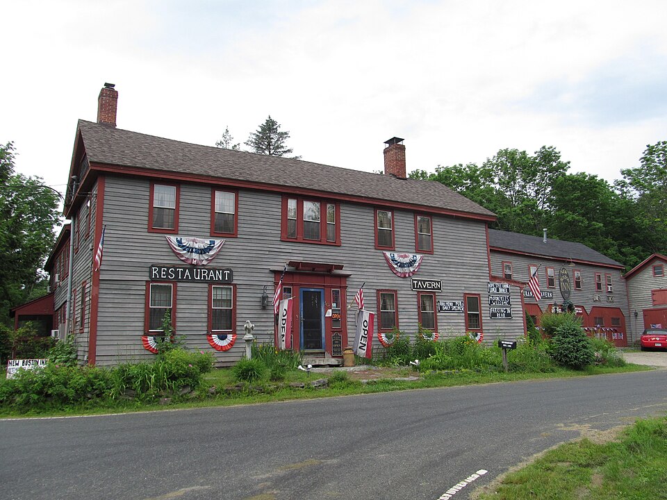
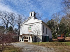
Built in 1750 in the Federal architecture. Listed on the National Register of Historic Places in
1988. A historic map-sheet match is not published yet. The record needs a coordinate-quality review before it can be joined to a sheet boundary.
From the record
“The New Boston Inn is a historic inn at 101 North Main Street, the junction of Massachusetts Routes 8 and 57 in the center of the New Boston village of Sandisfield, Massachusetts. With a construction history dating back to c. 1750, it is one of the oldest buildings in the town, and a prominent local example of Federal period architecture.”
Wikipedia article New Boston Inn, CC BY-SA 4.0.
one of 94 National Register listings in Berkshire County · listed in 1988 · category: Building · built in 1750, Federal architecture · one of 1 National Historic Landmarks in Berkshire County.
National Register reference number.88001459- the number the National Park Service assigned this property when it was listed, and the key its nomination file is catalogued under at the National Archives.
Fires near this property
8 since 2015
Regional context, not property-specific
evidence. The
federal wildfire occurrence database
lists 8 fires within 5 miles of New Boston Inn between
2015 and 2019, burning about 26 acres in total. None started naturally. None was recorded as arson.
Distance is straight-line from the map coordinates, so a fire counted
here may appear on a neighbouring settlement's page as well.
Reported cause
Fires
Debris and open burning
4
Missing data/not specified/undetermined
1
Equipment and vehicle use
1
Smoking
1
Recreation and ceremony
1
The most recent of
them, most recent first, with the day each was reported and the service
that recorded it.
Regional context, not property-specific
evidence. Museums hold 607 specimens
collected within 10 miles of New Boston Inn between 1873 and
1974: 376 Plantae, 157 Fungi, 72 Animalia, 2 Unrecorded. 12 distinct Species records are shown.
Collected by A. B. Seymour, A. B. Seymour & A. C. Seymour, A. Pealey and others. Each is a
physical object with a catalogue
number, and each entry opens the museum's record. This is what was
collected and kept, not a survey of what lives here - nothing can be
concluded from a species being absent.
Regional context, not property-specific
evidence. The National Weather Service names
Sandisfield, the town this property stands in, in 7 storm reports between 1994 and 2021: 3 hail, 3 thunderstorm wind, 1 flash flood.
No death or injury is recorded in these reports. Each account below is quoted exactly as the forecast office
filed it, from the NOAA Storm Events Database, and each date
opens the federal record of that event.
Severe thunderstorms brought large hail and very heavy rain. Nickel to golf ball-size hail lasted almost 20 minutes in Pittsfield and broke car windshields. Urban street flooding in Pittsfield reached a depth of two to three feet in city streets as storm drains backed up. The flooding lasted up to three hours. In Sandisfield, dime to quarter-size hail fell for five minutes.
No historic map-sheet match is published
for this property yet. That does not mean no map exists. This record needs
a coordinate-quality review before it can be joined to a sheet boundary.
Browse the county's mapped places while that work is
pending.
Named in the fire insurance atlases
Sanborn surveyors printed an index of the
town's establishments at the front of each atlas. This property is named in
one, read straight off the scanned sheet.
When this property was proposed for the
National Register, someone wrote the case for it: what the building is,
and why it matters. That document is a federal record in the public domain.
It is quoted below word for word, never summarised. The text was read off the scanned case file by machine, so the
occasional stray character is the recogniser's and the 1970s
typewriter's.
Statement of significance
New Boston Inn. Sandisfield. Massachusetts Certifyingofficial has considered the significance of this property in relation to other properties: nationally statewide X locally D Applicable National Register Criteria Criteria Considerations (Exceptions) Areas of Significance (enter categories from instructions) Architecture Conmerce Period of Significance ca. 1750 - 1938 Significant Dates ca. 1750 ca. 1800 Cultural Affiliation N/A Significant Person N/A Architect/Builder N/A State significance of property, and justify criteria,criteria considerations, and areas and periods of significance noted above.
The New Boston Inn, Sandisfield, a building complex with components dating from the mid-18th to the late 19th century, retains integrity of location, design, materials, workmanship, and association. The major landmark in the village of New Boston, the complex includes the best-preserved central-hall, Federal period building in Sandisfield, and has operated as an Inn nearly continuously for over 230 years to the present. The New Boston Inn represents anunusually well-preserved example of the type of rural hotel associated with the overland transport system of upland interior Massachusetts in the 18th and 19th centuries, and with the discovery of the scenic Berkshire uplands as a resortby early 20th-century automobile tourists.
As such it fulfills criteria A and C of the National Register of Historic Places. Housatonic Township Number Three (later Sandisfield) was one of four townships located between Westfield and Sheffield that were granted by the Massachusetts General Court in 1737. The township's proprietors were primarily_prominent Worcester County men speculating on the rise in value of western lands. By the early 1750s, the township's meadow lands and strong uplands soils were attracting settlers from the older: more densely populated towns to the south and east. In particular, many families came from Wethersfield, Connecticut and from Cape Cod.
Quoted from the National Register nomination
for reference 88001459, 25 pages, held by the National Archives in Record
Group 79. See the
catalogue record.
Listed places nearby
2 within 8 miles
Other National Register properties close
enough to walk or drive between, ordered by distance from this one. Both
positions come from the same geocoding pass that matched these properties
to their map sheets.
Listing record. National Park Service National Register of Historic Places, listed-properties dataset, current to 2026-05-22.
Map join. Address geocoded through the United States Census geocoder, then tested against the published boundary of every sheet in the USGS Historical Topographic Map Collection.
How this page is made. Listing fields come from federal records; map-sheet coverage is a labelled coordinate-to-boundary calculation, not a source-field claim.
Wildfire. Short, Karen C. 2022. Spatial wildfire occurrence data for the United States, 1992-2020 [FPA_FOD_20221014]. 6th Edition. Fort Collins, CO: Forest Service Research Data Archive. https://doi.org/10.2737/RDS-2013-0009.6 Collected with United States Government funding and usable without additional permissions or fees.
Specimens. Global Biodiversity Information Facility (GBIF), https://www.gbif.org/. Only records licensed CC0 or CC BY are used. Records licensed CC BY-NC are excluded because this site carries advertising. Images are checked individually and any whose licence is non-commercial, no-derivatives or unreadable is refused.
Storms. NOAA National Centers for Environmental Information, Storm Events Database https://www.ncei.noaa.gov/stormevents/ A work of the United States government, no copyright under 17 U.S.C. 105. Narratives are quoted verbatim from the National Weather Service report and are not edited or summarised.
 Block
Block