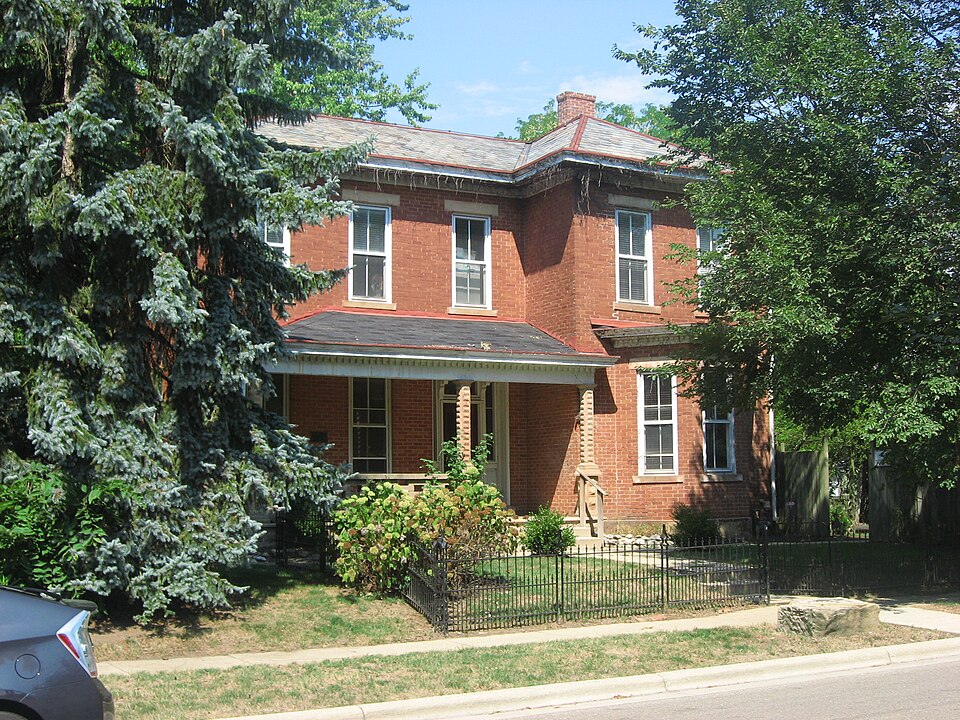
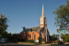
Listed on the National Register of Historic Places in
1989. A historic map-sheet match is not published yet. The record needs a coordinate-quality review before it can be joined to a sheet boundary.
From the record
one of 295 National Register listings in Franklin County · listed in 1989 · category: Building · one of 3 National Historic Landmarks in Franklin County.
National Register reference number.89001025- the number the National Park Service assigned this property when it was listed, and the key its nomination file is catalogued under at the National Archives.
Regional context, not property-specific
evidence. The
federal wildfire occurrence database
lists 1 fire within 5 miles of Carty, J.--R. J. Tussing House between
2010 and 2010, burning about 1 acres in total. None started naturally. None was recorded as arson.
Distance is straight-line from the map coordinates, so a fire counted
here may appear on a neighbouring settlement's page as well.
Reported cause
Fires
Debris and open burning
1
The most recent of
them, most recent first, with the day each was reported and the service
that recorded it.
Regional context, not property-specific
evidence. Museums hold 716 specimens
collected within 10 miles of Carty, J.--R. J. Tussing House between 1895 and
1975: 705 Animalia, 6 Fungi, 3 Unrecorded, 1 Plantae, 1 Chromista. 12 distinct Species records are shown.
Collected by Bill May, C. A. Petrovic, C. H. R. and others. Each is a
physical object with a catalogue
number, and each entry opens the museum's record. This is what was
collected and kept, not a survey of what lives here - nothing can be
concluded from a species being absent.
Regional context, not property-specific
evidence. The federal mineral resources record lists
2 workings within 5 miles of Carty, J.--R. J. Tussing House: 2 past producers.
None of them still produces. What was taken out: Sand and Gravel, Construction. Distance is straight-line from the
map coordinates, so a quarry counted here may appear on a neighbouring
settlement's page as well.
No historic map-sheet match is published
for this property yet. That does not mean no map exists. This record needs
a coordinate-quality review before it can be joined to a sheet boundary.
Browse the county's mapped places while that work is
pending.
From the nomination file
1,816 words on record
When this property was proposed for the
National Register, someone wrote the case for it: what the building is,
and why it matters. That document is a federal record in the public domain.
It is quoted below word for word, never summarised. The text was read off the scanned case file by machine, so the
occasional stray character is the recogniser's and the 1970s
typewriter's.
Statement of significance
Certitying official has considered the significance of this property in relation to other properties: Areas of Significance (enter categories from instructions) Period of Significance 1874 - 1897 Significant Person Significant exterior details include the single door entry, slate roof, X Soe continuation sheet commerce Unknown architecture Cultural Affiliation North High Street Historic District. Jacob Carty Significant Dates part owner/founder of the winchester Mills. noninated individually and one example is within the boundaries of the floors, wood trin and baseboards, and central staircase with turned Architect/Builder design, all of which are brick.Three of the examples are being spindles, newel post and paneling.
This is one of four houses in the incorporated limits with Italianate Jacob Carty acquired two acres and 82 poles of land in this area in 1868 Waterloo Streets inafrane house constructed in 1840,prior to his move is said to have been a resident here in c.1926. -statewide Applicable National Register Criteria Criteria Considerations (Exceptions) 212 light double hung windows, corbeled chimneys, dentiled entablature, and front bay with cornice. Jacob Carty (1805-1897) was one of four founders of the Winchester Millg Historic Context E.2.
"Agricultural Commerce: Railroad Era, 1869-1904" as nationally Israel Julian.The Carty & Julian store was located on the Town Lot on Intact interior details include the wood early 2oth century precast concrete porch.It is also significant under High Street.As early as 1834 or 1835,Carty and Rodgers built a frame in 1868,which was 1ocated just north of this property across the Hocking 1897 and the property was sold to Rudolph Judson Tussing in 1898. OMB Aoprovel No. 1024-0018 National Park Service Description, Statement of Sig. cont. 8. Statement of Significance continued Whitehurst (Whitehurst & Carty) which becane the Whitehurst, (John) Gehn, & Co. between 1860 and 1870, and Whitehurst, Lehman & Carty in 1877.
Quoted from the National Register nomination
for reference 89001025, 13 pages, held by the National Archives in Record
Group 79. See the
catalogue record.
Listed places nearby
6 within 8 miles
Other National Register properties close
enough to walk or drive between, ordered by distance from this one. Both
positions come from the same geocoding pass that matched these properties
to their map sheets.
Listing record. National Park Service National Register of Historic Places, listed-properties dataset, current to 2026-05-22.
Map join. Address geocoded through the United States Census geocoder, then tested against the published boundary of every sheet in the USGS Historical Topographic Map Collection.
How this page is made. Listing fields come from federal records; map-sheet coverage is a labelled coordinate-to-boundary calculation, not a source-field claim.
Wildfire. Short, Karen C. 2022. Spatial wildfire occurrence data for the United States, 1992-2020 [FPA_FOD_20221014]. 6th Edition. Fort Collins, CO: Forest Service Research Data Archive. https://doi.org/10.2737/RDS-2013-0009.6 Collected with United States Government funding and usable without additional permissions or fees.
Specimens. Global Biodiversity Information Facility (GBIF), https://www.gbif.org/. Only records licensed CC0 or CC BY are used. Records licensed CC BY-NC are excluded because this site carries advertising. Images are checked individually and any whose licence is non-commercial, no-derivatives or unreadable is refused.
Mines and quarries. USGS Mineral Resources Data System (MRDS) https://mrdata.usgs.gov/mrds/ A work of the United States government, no copyright under 17 U.S.C. 105.
 Block
Block