Listed on the National Register of Historic Places in
1991. A historic map-sheet match is not published yet. The record needs a coordinate-quality review before it can be joined to a sheet boundary.
From the record
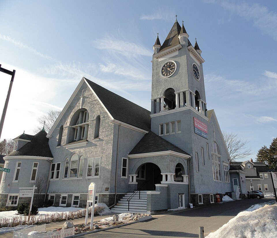
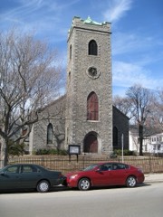
“Roslindale Congregational Church is a historic Congregational church at 25 Cummins Highway, at the corner of Summer Avenue in the Roslindale neighborhood of Boston, Massachusetts. The Shingle-Romanesque style church was designed by James Murray and built 1893-96 for a congregation established in 1890 by Rev.”
Wikipedia article Roslindale Congregational Church, CC BY-SA 4.0.
one of 206 National Register listings in Suffolk County · listed in 1991 · category: Building · one of 5 National Historic Landmarks in Suffolk County.
National Register reference number.91000925- the number the National Park Service assigned this property when it was listed, and the key its nomination file is catalogued under at the National Archives.
What happened here
An account from the chapter on Boston city, The inset identifies its exact
source book and publication year.
IN giving some notices of manners and social life during this period, I shall speak first of usages which were characteristic of the close of the last century: most of them continued without essential modification until our city charter swept away the old landmarks, and Boston felt the im¬ pulses which mark a new epoch in her history.
2 These were at South Boston in 1S72-73 ; at Roxbury in 1873-74, where a union was made with the Fellowes Athenaeum, and a new building erected; at Charlestown and Brighton, the same year, by assuming the charge of the libraries existing in those places before the annexation of them; at Dorchester in 1874-75 ; at the South End, where the Mercantile Library added their books, and at Jamaica Plain, in 1877-78. There was also a delivery at Dorchester Lower Mills, dependent on the Branch at Field's Corner. Since this date a delivery has been established at Roslindale, and a secondary branch at West Roxbury, upon the basis of the privately sup¬ ported free library previously existing there.
(VI) Abigail Russell Hapgood, daughter of David Hapgood (5), born April 28, 1819, died at Roslindale, March 9, 1888. She married. May 21, 1842, John Ingalls Taylor, born at Salem, Massachusetts, May 21, 1816, died at Haverhill, March 31, 1890, son of John and Olive Taylor. They resided in Charlestown, where all their children were born. Children : i . Mary Elizabeth Taylor, born January 15, 1843; married August 16, 1867, R. L. Spear, of Boston, who died June 12, 1892.
Regional context, not property-specific
evidence. The
federal wildfire occurrence database
lists 63 fires within 5 miles of Roslindale Congregational Church between
2003 and 2020, burning about 373 acres in total. None started naturally. None was recorded as arson.
Distance is straight-line from the map coordinates, so a fire counted
here may appear on a neighbouring settlement's page as well.
Reported cause
Fires
Missing data/not specified/undetermined
25
Recreation and ceremony
21
Smoking
13
Equipment and vehicle use
4
The most recent of
them, most recent first, with the day each was reported and the service
that recorded it.
Regional context, not property-specific
evidence. Museums hold 13,843 specimens
collected within 10 miles of Roslindale Congregational Church between 1810 and
1975: 5,427 Plantae, 4,248 Fungi, 3,420 Animalia, 327 Chromista, 205 Protozoa, 138 Bacteria, 78 Unrecorded. 12 distinct Species records are shown.
Collected by (MARSDEN, H W), ?, A B Seymour and others. Each is a
physical object with a catalogue
number, and each entry opens the museum's record. This is what was
collected and kept, not a survey of what lives here - nothing can be
concluded from a species being absent.
Regional context, not property-specific
evidence. The federal mineral resources record lists
1 working within 5 miles of Roslindale Congregational Church: 1 unknown.
None of them still produces. What was taken out: Stone, Crushed/Broken. Distance is straight-line from the
map coordinates, so a quarry counted here may appear on a neighbouring
settlement's page as well.
No historic map-sheet match is published
for this property yet. That does not mean no map exists. This record needs
a coordinate-quality review before it can be joined to a sheet boundary.
Browse the county's mapped places while that work is
pending.
From the nomination file
4,302 words on record
When this property was proposed for the
National Register, someone wrote the case for it: what the building is,
and why it matters. That document is a federal record in the public domain.
It is quoted below word for word, never summarised. The text was read off the scanned case file by machine, so the
occasional stray character is the recogniser's and the 1970s
typewriter's.
Statement of significance
Certifying official has considered the significance of this property in relation to other properties: Jnationally -statewide IX locally D Applicable National Register Criteria Criteria Considerations (Exceptions) XA Areas of Significance (enter categories from instructions) Architecture Community Development LE LG Period of Significance 1893-1941 Significant Dates 1893 Cultural Affiliation N/A Significant Person N/A Architect/Builder James: Murry State significance of property, and justify criteria, criteria considerations, and areas and periods of significance noted above. SIGNIFICANCE The Roslindale Congregational Church possesses integrity of location, des1gn, setting, materials, workmanship, feeling, and association.
The Church is an outstanding example of the shingle style influenced by the Richardsonian Revival style. The church is a rare example of its type in Boston, and its monumental scale and prominent location make it an essential part of the Roslindale Village section of Roslindale. The founding of this congregation illustrates the migration of Boston's population to the surrounding suburbs, and the exemplifies the success of Congregationalism in and around Boston during this. period. The Roslindale Congregational Church meets Criteria A and C and Exception A of the National Register of Historic Places at the local level.
Historical Congregationalism has played an important role in the history of Massachusetts histor Both the development of the public school system and the founding of Harvard University were products of Congregationalist "thought and purpose." The Centennial History also chronicles the important roles that Congregationalists played during the American Revolution and throughout the Anti-slavery movement. During the period 1880-1930, the Congregational denomination in Boston expanded its membership and maintained its prominent role in society. In 1880 Boston had 27 Congregational churches with 9795 members -- by 1930 there were 34 churches with 18,677 members. The Reverend George A.
Quoted from the National Register nomination
for reference 91000925, 20 pages, held by the National Archives in Record
Group 79. See the
catalogue record.
Listed places nearby
6 within 8 miles
Other National Register properties close
enough to walk or drive between, ordered by distance from this one. Both
positions come from the same geocoding pass that matched these properties
to their map sheets.
Listing record. National Park Service National Register of Historic Places, listed-properties dataset, current to 2026-05-22.
Map join. Address geocoded through the United States Census geocoder, then tested against the published boundary of every sheet in the USGS Historical Topographic Map Collection.
How this page is made. Listing fields come from federal records; map-sheet coverage is a labelled coordinate-to-boundary calculation, not a source-field claim.
Wildfire. Short, Karen C. 2022. Spatial wildfire occurrence data for the United States, 1992-2020 [FPA_FOD_20221014]. 6th Edition. Fort Collins, CO: Forest Service Research Data Archive. https://doi.org/10.2737/RDS-2013-0009.6 Collected with United States Government funding and usable without additional permissions or fees.
Specimens. Global Biodiversity Information Facility (GBIF), https://www.gbif.org/. Only records licensed CC0 or CC BY are used. Records licensed CC BY-NC are excluded because this site carries advertising. Images are checked individually and any whose licence is non-commercial, no-derivatives or unreadable is refused.
Mines and quarries. USGS Mineral Resources Data System (MRDS) https://mrdata.usgs.gov/mrds/ A work of the United States government, no copyright under 17 U.S.C. 105.
 Block
Block