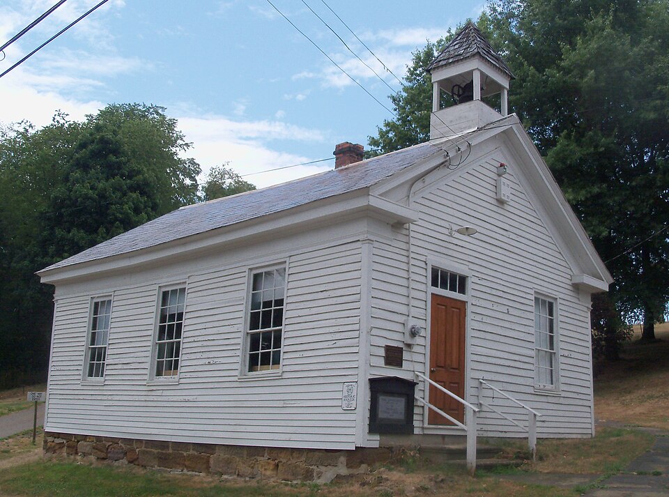
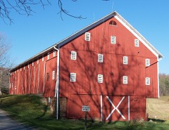
Listed on the National Register of Historic Places in
1994. A historic map-sheet match is not published yet. The record needs a coordinate-quality review before it can be joined to a sheet boundary.
From the record
“Conrad Rager, the proprietor, came to the township from Pennsylvania in 1828. He purchased forty acres and erected a cabin, soon after building an addition to the dwelling and stocking it with goods, thus becoming the first merchant in the township.”
The History of Tuscarawas County, Ohio (1884). Machine-read text.
one of 20 National Register listings in Tuscarawas County · listed in 1994 · category: Building · one of 1 National Historic Landmarks in Tuscarawas County.
National Register reference number.94000777- the number the National Park Service assigned this property when it was listed, and the key its nomination file is catalogued under at the National Archives.
The ground it stands on
3,478 words
The chapter on Auburn Township in The History of Tuscarawas County, Ohio, published 1884 names Ragersville. This is what it says, exactly as the scans read.
The mineral resources of Auburn are unexcelled in the county. In the ridge about two and a half miles northeast from Ragersville, is found a tenfoot vein of blackband iron ore* from which immense quantities have been shipped to Massillon and Dover. The ore is conveyed by a train road a distance of two and a half miles to Blackband Station* on the C. & M. Railroad. Large quantities of mountain ore exist, and four- foot veins of coal are abundant* but are not worked except for home consumption.
The exact date of Auburn's first settlement is not known. John Mizer was the first pioneer, and he came before 1809, probably as early as 1806. Originally from Pennsylvania, he had settled near Salem, Harrison County, and thence came to Tuscarawas, and entered and removed to the northwest quarter of Section 12, in the northwest portion of the township. He was a famous hunter, and spent most of his time in the forests. Dwelling here for a while, he removed with his family to the northwest quarter of Section 1, a mile south of Ragersville. Many were his exploits with wild animals in the solitudes of the wilderness, where he often remained over night. Once when sleeping amid the branches of a fallen tree, he was awakened by the sniffing of a large animal near him. Lying motionless till the animal had receded some distance and was standing on an adjoining log, he leveled his rifle and shot. A loud cry followed and a tumble. In the morning, a large bear, weighing 700 pounds, was found, shot through the heart. Two other bears were killed by Mr. Mizer that day. On another occasion, he espied two cubs and shot ona He seized the other, with intent to carry it home alive, but its piteous cry attracted the mother, which rushed to the rescue with such hot haste that the hunter had little time to reload his weapon. Dropping the squalling cub, he poured some powder in the barrel of his gun and two naked bullets on top. Turning the gun just as the bear was about to reach him, he shot and killed her. Mr. Mizer remained in Auburn Township till game was getting scarce, and his favorite occupation became no longer possible. He then removed to the hills of Coshocton County, where game was yet abundant, and where he died in 1860, aged seventy -seven years. His sons, Jacob and George, now reside in Bucks Township.
Regional context, not property-specific
evidence. The
federal wildfire occurrence database
lists 7 fires within 5 miles of Ragersville School between
2005 and 2017, burning about 9 acres in total. None started naturally. None was recorded as arson.
Distance is straight-line from the map coordinates, so a fire counted
here may appear on a neighbouring settlement's page as well.
Reported cause
Fires
Debris and open burning
5
Smoking
1
Recreation and ceremony
1
The most recent of
them, most recent first, with the day each was reported and the service
that recorded it.
Regional context, not property-specific
evidence. Museums hold 272 specimens
collected within 10 miles of Ragersville School between 1851 and
1973: 161 Animalia, 97 Plantae, 13 Fungi, 1 Unrecorded. 12 distinct Species records are shown.
Collected by A. Cibula, A. Cobula, A. Woolman and others. Each is a
physical object with a catalogue
number, and each entry opens the museum's record. This is what was
collected and kept, not a survey of what lives here - nothing can be
concluded from a species being absent.
Regional context, not property-specific
evidence. The federal mineral resources record lists
17 workings within 5 miles of Ragersville School: 9 past producers, 7 producers, 1 occurrence.
7 still produce. What was taken out: Clay, Clay, Coal, Fire Clay (Refractory), Iron. Distance is straight-line from the
map coordinates, so a quarry counted here may appear on a neighbouring
settlement's page as well.
Regional context, not property-specific
evidence. The National Weather Service names
Ragersville, the town this property stands in, in 7 storm reports between 2002 and 2025: 6 thunderstorm wind, 1 flash flood.
No death or injury is recorded in these reports. Each account below is quoted exactly as the forecast office
filed it, from the NOAA Storm Events Database, and each date
opens the federal record of that event.
Several reports of damage in the town of Ragersville from social media. This includes: a barn roof blown off at the intersection of Ragersville Road and Eckert Road. There were also several other reports of trees down and a small outbuilding had it's roof blow off on Crooked Run Road.
No historic map-sheet match is published
for this property yet. That does not mean no map exists. This record needs
a coordinate-quality review before it can be joined to a sheet boundary.
Browse the county's mapped places while that work is
pending.
From the nomination file
2,155 words on record
When this property was proposed for the
National Register, someone wrote the case for it: what the building is,
and why it matters. That document is a federal record in the public domain.
It is quoted below word for word, never summarised. The text was read off the scanned case file by machine, so the
occasional stray character is the recogniser's and the 1970s
typewriter's.
Statement of significance
X A Property is associated with events that have made X C Property embodies the distinctive characteristics of a type, period, or method of construction or represents the work of a master, or possesses high artistic values, or represents a significant and ca. 1830 - D Property has yielded, or is likely to yield, information important in prehistory or history. -A owned by a religious institution or used for - B removed from its original location. - C a birthplace or grave. - D a cemetery. - E a reconstructed building, object, or structure. - F a commemorative property. -G less than 50 years of age or achieved significance within the past 50 years.
Quoted from the National Register nomination
for reference 94000777, 15 pages, held by the National Archives in Record
Group 79. See the
catalogue record.
Listed places nearby
1 within 8 miles
Other National Register properties close
enough to walk or drive between, ordered by distance from this one. Both
positions come from the same geocoding pass that matched these properties
to their map sheets.
Listing record. National Park Service National Register of Historic Places, listed-properties dataset, current to 2026-05-22.
Map join. Address geocoded through the United States Census geocoder, then tested against the published boundary of every sheet in the USGS Historical Topographic Map Collection.
How this page is made. Listing fields come from federal records; map-sheet coverage is a labelled coordinate-to-boundary calculation, not a source-field claim.
Wildfire. Short, Karen C. 2022. Spatial wildfire occurrence data for the United States, 1992-2020 [FPA_FOD_20221014]. 6th Edition. Fort Collins, CO: Forest Service Research Data Archive. https://doi.org/10.2737/RDS-2013-0009.6 Collected with United States Government funding and usable without additional permissions or fees.
Specimens. Global Biodiversity Information Facility (GBIF), https://www.gbif.org/. Only records licensed CC0 or CC BY are used. Records licensed CC BY-NC are excluded because this site carries advertising. Images are checked individually and any whose licence is non-commercial, no-derivatives or unreadable is refused.
Mines and quarries. USGS Mineral Resources Data System (MRDS) https://mrdata.usgs.gov/mrds/ A work of the United States government, no copyright under 17 U.S.C. 105.
Storms. NOAA National Centers for Environmental Information, Storm Events Database https://www.ncei.noaa.gov/stormevents/ A work of the United States government, no copyright under 17 U.S.C. 105. Narratives are quoted verbatim from the National Weather Service report and are not edited or summarised.
 Block
Block