 Block
From the record
14 National Register listings published here.
Sources: the National Register database, National Park Service
31 topographic sheets and 6 fire insurance atlases across 1 place.
14 National Register listings published here.
Sources: the National Register database, National Park Service
Taken for the Office of War Information and the Farm Security Administration, who photographed the country between 1935 and 1944. Works of United States government photographers, with no known restriction on use. Each opens its catalogue record.

Every property in this county listed on the National Register of Historic Places, with the year it was listed and the federal nomination document.
| Photograph | Property | Type | Listed | Reference |
|---|---|---|---|---|
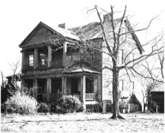 | William Baker House | building | 1978 | 78002494 |
 | Col. J. A. Banks House | building | 1980 | 80003655 |
 | Calhoun County Courthouse | building | 1981 | 81000561 |
 | Calhoun County Library | building | 1975 | 75001690 |
| Cherokee Path, Sterling Land Grant | site | 1976 | 76001696 | |
| Culclasure-Geiger Farmstead | district | 2023 | 100008999 | |
 | Col. Olin M. Dantzler House | building | 1973 | 73001680 |
 | Haigler House | building | 2001 | 01001099 |
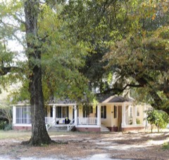 | David Houser House | building | 1980 | 80003656 |
 | Midway Plantation | building | 1976 | 76001694 |
 | Oakland Plantation | building | 1975 | 75001689 |
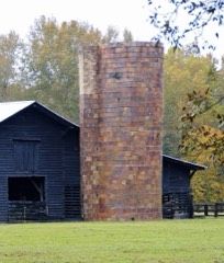 | Puritan Farm | building | 1974 | 74001829 |
 | Ulmer-Summers House | building | 1973 | 73001679 |
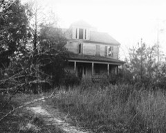 | Zante Plantation | building | 1976 | 76001695 |
Flown by the U.S. Geological Survey between 1937 and 1989, the Aerial Photo Single Frames collection is the definitive mid-century view of the land: fields, roads and rivers as the camera saw them. The Survey holds 1,661 frames inside the rectangle that bounds this county; the 41 frames below were taken over the county itself, chosen across the decades of flights (at most four a year from that rectangle), so one flight cannot crowd out the rest. The full set is free to browse and download at EarthExplorer under the dataset Aerial Photo Single Frames.









































The thermometers that kept this county's weather, and the gages that measured the flow of its streams, as the federal records hold them. The extremes below are measured values from those records, not estimates.
Who lived here in 1950, one enumeration district at a time, as the Census Bureau described each district. Each row opens its official National Archives result, with Population Schedules and ED Maps available there.
Every wildfire the federal occurrence database records inside this county: 1,005 of them, burning about 3,746 acres. 34 started naturally and 45 were recorded as arson. Each settlement page carries the fires within five miles of it.
| Reported cause | Fires |
|---|---|
| Debris and open burning | 474 |
| Missing data/not specified/undetermined | 276 |
| Equipment and vehicle use | 108 |
| Arson/incendiarism | 45 |
| Natural | 34 |
| Smoking | 32 |
| Misuse of fire by a minor | 23 |
| Power generation/transmission/distribution | 8 |
| Recreation and ceremony | 4 |
| Railroad operations and maintenance | 1 |
The five largest, by the area the report gives. One of them was set deliberately.
| Date | Cause | Size | Reported by | Name on the report |
|---|---|---|---|---|
| 5 March 1996 | Missing data/not specified/undetermined | 290 acres | South Carolina Forestry Commission | not named |
| 5 March 2005 | Natural | 82 acres | South Carolina Forestry Commission | not named |
| 14 May 2014 | Debris and open burning | 75 acres | South Carolina Forestry Commission | not named |
| 25 May 2000 | Smoking | 65 acres | South Carolina Forestry Commission | not named |
| 28 February 2002 | Equipment and vehicle use | 65 acres | South Carolina Forestry Commission | not named |
| 31 January 1998 | Debris and open burning | 65 acres | South Carolina Forestry Commission | not named |
| 16 February 1999 | Arson/incendiarism | 50 acres | South Carolina Forestry Commission | not named |
| 3 March 1996 | Missing data/not specified/undetermined | 45 acres | South Carolina Forestry Commission | not named |
Every settlement page carries the fires within five miles of it - see the settlement index below.
The NOAA Storm Events Database holds 327 reports for this county, causing 1 death, 9 injuries and about $8,155,310 in recorded property damage. Each settlement page carries the reports that name it.
| Kind of event | Reports |
|---|---|
| Thunderstorm Wind | 204 |
| Hail | 83 |
| Tornado | 28 |
| Flash Flood | 8 |
| Flood | 2 |
| Lightning | 1 |
| Heavy Rain | 1 |
The most serious of them, by death, then injury, then recorded damage. The accounts are quoted exactly as the forecast office filed them.
| When | Event | Place named | Harm | What the report says |
|---|---|---|---|---|
| October 1990 | Tornado (F2) | not stated | 1 killed, 4 hurt, $250,000 | no account filed |
| April 2015 | Tornado (EF1) | Hammond Xrds | 2 hurt, $200,000 | NWS storm survey found an EF1 tornado destroyed a mobile home on Otts Sisters Road injuring two people, damaged another, and also did minor damage to industrial facility. Numerous trees were also down along the path of the tornado. |
| March 1974 | Tornado (F1) | not stated | 1 hurt, $250,000 | no account filed |
| December 2004 | Tornado (F2) | St Matthews | 1 hurt | Damage survey found an F2 tornado tore most of the concrete roof off a warehouse and damaged several vehicles and other outbuildings. |
| July 2003 | Lightning | St Matthews | 1 hurt | Lightning struck a State Trooper at I-26 and exit 139 injuring him. |
| October 2015 | Flash Flood | St Matthews | $5,000,000 | Several roads closed due to flooding including portions of HWY 6 between St.Matthews and Elloree. |
| October 2015 | Flash Flood | Hammond Xrds | $500,000 | SC Highway Patrol reports roadway flooding on I-26 eastbound at mile marker 124. |
| November 2008 | Tornado (EF1) | Lone Star | $500,000 | Storm survey found an EF1 touched down just southwest of Lone Star and continued northeast across Lake Marion into rural Sumter county. The most significant damage occurred near Lone Star along McCords Ferry road just south of Tinah road. At that location several homes lost portions of their roofs and numerous trees and powerlines were down. The tornado moved northeast across Broomstraw road where several outbuildings lost roofs or were destroyed. |
| November 1995 | Tornado (F2) | Elloree | $400,000 | Tornado severely damaged horse training center, track ,and home. |
| April 2011 | Tornado (EF1) | Ft Motte | $250,000 | NWS Storm Survey confirmed a HAM radio report of a tornado touchdown southwest of Ft. Motte. An EF1 tornado with winds of near 100mph took down numerous trees and powerlines, damaged a farm, and rolled over a large section of a field irrigation system. Nickel size hail was also reported. |
| April 1997 | Thunderstorm Wind | St Matthews | $250,000 | no account filed |
| November 2011 | Thunderstorm Wind | Cameron | $80,000 | Storm survey found significant damage to Browns Chapel Church. The steeple was blown off, several windows were blown out from the wind getting in on the southwest side, and several trees were down. Shingles, facia, and soffett were also torn off. |
| April 2011 | Thunderstorm Wind | St Matthews | $60,000 | HAM radio and storm survey found trees down, stop signs bent over, uprooted trees, powerlines down, and a home significantly damaged from a tree falling on it. |
| January 1995 | Thunderstorm Wind | St Matthews | $50,000 | Trees and power lines down in the St. Matthews area. |
| February 1971 | Tornado (F1) | not stated | $25,000 | no account filed |
| April 1958 | Tornado (F2) | not stated | $25,000 | no account filed |
| June 2015 | Thunderstorm Wind | Cameron | $24,000 | EM's reported many trees down along with powerlines between Cameron and Elloree. Structural damage also occurred to several out buildings. |
| April 2015 | Thunderstorm Wind | Hammond Xrds | $16,000 | Strong straight line winds produced some damage to a home just off of Bull Swamp Road. The strong winds damaged the roof of the home and also blew out a wall on the northeast side of the house. There were also some medium size limbs down. |
| June 2012 | Tornado (EF0) | Cameron | $16,000 | SCEG reported several trees and powerlines down from a weak tornado near Cameron. |
| April 2009 | Thunderstorm Wind | St Matthews | $15,000 | WIS TV showed video of trees down on home in St. Matthews area. |
| June 2015 | Thunderstorm Wind | Lone Star | $14,000 | EM reported multiple trees and utility poles down in Lonestar. |
| June 2015 | Thunderstorm Wind | Cameron | $14,000 | EM reported multiple trees and utility poles and lines down in Cameron. |
| February 2012 | Thunderstorm Wind | Lone Star | $12,000 | Dispatch reported trees down east of St. Matthews near Lake Marion along Hwy 267. |
| October 2016 | Flash Flood | Lone Star | $10,000 | South Carolina Hwy. Patrol reported the roadway washed out on Good Hope Road near Hwy. 267 McCords Ferry Road. They also reported a Stump Hole Road flooded. |
| April 2011 | Thunderstorm Wind | Hammond Xrds | $10,000 | Sheriff reported powerlines down with outages in the Sandy Run area. |
| July 2006 | Thunderstorm Wind | St Matthews | $10,000 | An intense microburst took down many very large trees, one partially fell on a home. Two boats were also moved from a larger pond to a smaller one. The event occurred at 439 Savany Hunt Creek road. |
| June 2015 | Thunderstorm Wind | Hammond Xrds | $8,000 | Sheriff reported trees down in the Sandy Run area including Valley Ridge Road. |
| January 2013 | Thunderstorm Wind | St Matthews | $8,000 | EMD reported trees down on powerlines in the St. Matthews area. |
| March 2013 | Thunderstorm Wind | Hammond Xrds | $8,000 | Highway Patrol reported trees down along Gardner Farm Road. |
| May 2012 | Thunderstorm Wind | Cameron | $8,000 | Highway Patrol reported trees down near the intersection of Hwy 176 and St. John Road. |
| July 2012 | Thunderstorm Wind | Lone Star | $8,000 | Tri County Electric COOP reported trees and powerlines down near Lone Star. |
| August 2011 | Thunderstorm Wind | Ft Motte | $8,000 | TRI-COUNTY Electric reported outages due to down power lines. |
| June 2011 | Thunderstorm Wind | Hammond Xrds | $8,000 | COOP reported trees and powerlines down. |
| July 2010 | Thunderstorm Wind | St Matthews | $8,000 | EM reported powerlines and trees down in St. Matthews and areas south of town toward I-26. |
| August 2015 | Thunderstorm Wind | Ft Motte | $6,000 | Dispatch reported multiple trees down around Ft. Motte. |
| August 2015 | Thunderstorm Wind | Cameron | $6,000 | Dispatch reported trees down on Cameron Road at U.S. 176. |
| June 2015 | Thunderstorm Wind | Cameron | $6,000 | Highway Patrol reported trees down on Winding Brook Drive. |
| October 2016 | Flash Flood | Hammond Xrds | $5,000 | South Carolina Hwy. Patrol reported a portion of Old State Road was washed out. |
| June 2013 | Thunderstorm Wind | Hammond Xrds | $4,000 | Electric COOP reported trees and limbs down on powerlines at Valley Ridge Road and Hwy 176. |
| May 2012 | Thunderstorm Wind | Creston | $4,000 | Sheriff reported trees down near Elloree. |
| June 2011 | Thunderstorm Wind | Riley | $4,000 | Highway Patrol reported trees down ant Murph Mill road and Seetwater Lane. |
| June 2011 | Thunderstorm Wind | St Matthews | $4,000 | Sheriff reported trees and powerlines down near Hwy 176 and Caw Caw road. |
| August 2011 | Thunderstorm Wind | Creston | $4,000 | Sheriff reported trees down on Jericho Road. |
| June 2011 | Thunderstorm Wind | St Matthews | $4,000 | Highway Patrol reported trees down near SC 6 and US 176. |
| June 2011 | Thunderstorm Wind | Riley | $4,000 | Highway Patrol reported trees in the roadway near Burke road and Kinley road. |
| June 2010 | Thunderstorm Wind | Ft Motte | $4,000 | DOT reported trees down in the Ft. Motte area. |
| June 2015 | Thunderstorm Wind | Lone Star | $3,000 | Highway Patrol reports trees down at 3 Bridges Road and McCords Ferry Road. |
| June 2015 | Thunderstorm Wind | Hammond Xrds | $3,000 | Dispatch reported trees down on Old State Road near Sandy Run. |
| June 2011 | Thunderstorm Wind | Riley | $3,000 | A county official reported trees down on Bull Swamp road. |
| June 2011 | Thunderstorm Wind | Hammond Xrds | $3,000 | Dispatch reported trees down on Bull Swamp road. |
| November 2010 | Thunderstorm Wind | Hammond Xrds | $3,000 | DOT reported trees down near mile marker 133 on I-26. |
| July 2010 | Thunderstorm Wind | Hammond Xrds | $3,000 | Sheriff reported trees down on Hwy 172 and Kaigler Ave. |
| June 2009 | Thunderstorm Wind | Creston | $3,000 | County reported several trees down near hwy 6 in southern Calhoun county north of Ellorree. |
| July 2009 | Thunderstorm Wind | Hammond Xrds | $3,000 | DOT reported a couple of trees down on hwy 176 east of Sandy Run. |
| June 2015 | Thunderstorm Wind | Creston | $2,000 | Highway Patrol reported trees down on Hwy 6 near Hwy 33. |
| June 2015 | Thunderstorm Wind | Lone Star | $2,000 | Public reports a couple of trees down on Hwy 267 just north of Lonestar. |
| May 2013 | Flood | Hammond Xrds | $2,000 | The Congaree River at Carolina Eastman was 5.7 feet over flood stage. Minor flooding along the river at the plant occurred. |
| August 2012 | Thunderstorm Wind | Lone Star | $2,000 | Park Service reported trees down in the backyard of the Ranger Home Residence. |
| June 2012 | Thunderstorm Wind | Lone Star | $2,000 | Public reported a couple of trees down on McCords Ferry Road. |
| June 2012 | Thunderstorm Wind | Lone Star | $2,000 | Highway Patrol reported a couple of trees down on Old River Road blocking the highway near the west end of Santee State Park. |
The Survey's mineral resources record lists 8 workings inside this county. 3 still produce and 5 are closed or unrecorded. Each settlement page carries the workings within five miles of it.
| Commodity | Workings |
|---|---|
| Clay | 5 |
| Sand and Gravel, Construction | 2 |
| Copper | 1 |
The least common of them first, because a county's hundredth gravel pit says nothing its first ten did not.
| Where | Site | Commodity | Status | Recorded |
|---|---|---|---|---|
| (Facility) Gaston Copper Smelter | Copper | Plant | ||
| Cleckley Pit | Sand and Gravel, Construction | Unknown | Sedimentary | |
| Cleckley Pit | Sand and Gravel, Construction | Past Producer | ||
| Kenyon Mine West | Clay | Unknown | Sedimentary | |
| Mccurry Pit | Clay | Past Producer | Sedimentary | |
| Roof Mine | Clay | Producer | Sedimentary | |
| Roof Pit | Clay | Producer | ||
| Unnamed Fullers Earth Pit | Clay | Unknown | Sedimentary |
Named settlements recorded in the Geographic Names Information System, each with the topographic sheets covering it. Villages, hamlets and abandoned places alike. Each is shown with the nearest named watercourse or landform and the survey quadrangle it falls on. The 1 place that was also surveyed for fire insurance comes first, with the number of atlases and photographs held for them.
St. Matthews census division · 29135 · Saint Matthews quadrangle
13 sheets, 1946 to 1990
Fire insurance: 6 atlases
Cameron census division · 29030 · On Bay Branch · Cameron quadrangle
13 sheets, 1946 to 1990
Fort Motte-Lone Star census division · 29135 · On True Blue Creek · Fort Motte quadrangle
13 sheets, 1946 to 1990
Sandy Run-Staley Crossroads census division · 29135 · Saint Matthews quadrangle
13 sheets, 1946 to 1990
Fort Motte-Lone Star census division · 29030 · Lone Star quadrangle
13 sheets, 1946 to 1990
Sandy Run-Staley Crossroads census division · 29160 · Saylors Lake quadrangle
16 sheets, 1948 to 1990
Sandy Run-Staley Crossroads census division · 29160 · Saylors Lake quadrangle
16 sheets, 1948 to 1990
Sandy Run-Staley Crossroads census division · 29112 · Staley Crossroads quadrangle
13 sheets, 1946 to 1990
St. Matthews census division · 29135 · On Sikes Creek · Saint Matthews quadrangle
13 sheets, 1946 to 1990
Fort Motte-Lone Star census division · 29030 · On Warley Creek · Lone Star quadrangle
13 sheets, 1946 to 1990
St. Matthews census division · 29135 · Saint Matthews quadrangle
13 sheets, 1946 to 1990
Fort Motte-Lone Star census division · 29135 · Fort Motte quadrangle
13 sheets, 1946 to 1990
13 topographic sheets and 6 fire insurance atlases, 1894 to 1935
The complete index, with nothing left out. Each of these is a separate record with its own page: a federal survey report, or the case file that argued a property on to the National Register. Both are public domain and reproduced word for word.