
BlockBefore
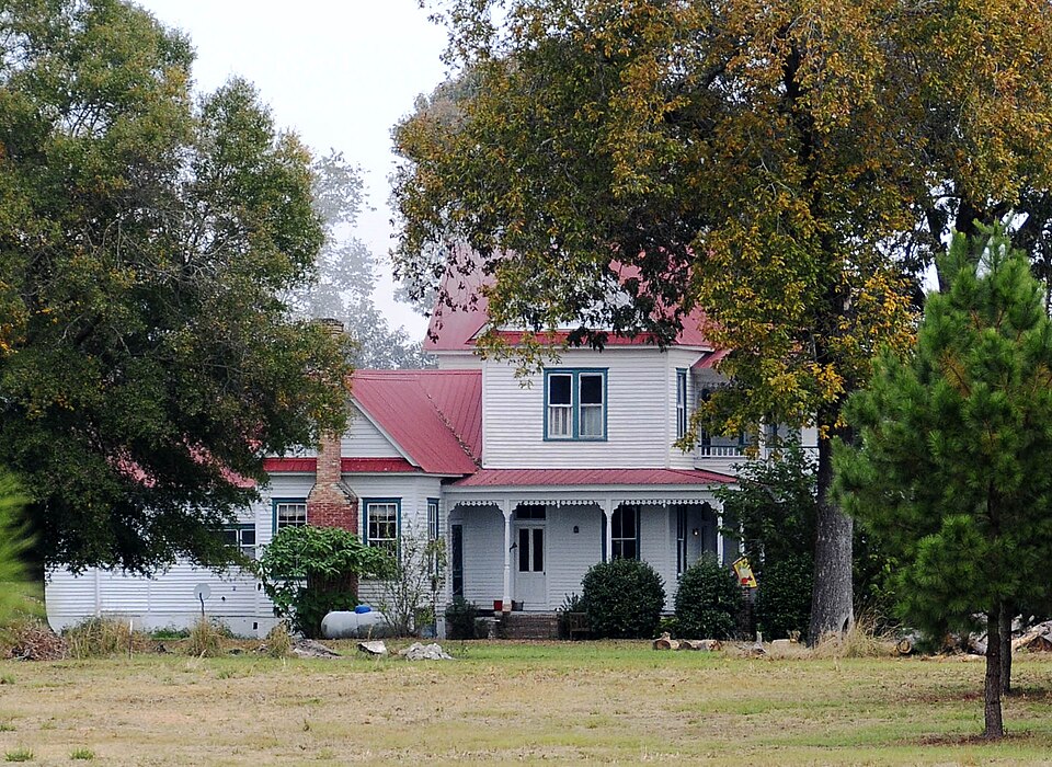
Photograph of Haigler House
Photograph by Bill Fitzpatrick, CC BY-SA 3.0. Via Wikimedia Commons.

Haigler House

Listed on the National Register of Historic Places in 2001.

From the record

“Haigler House is a historic home located near Cameron, Calhoun County, South Carolina with approximately fifteen acres of land. It was built in 1893 by Thomas Shadrack Haigler, and is a simple two-story, frame, Queen Anne style farmhouse accentuated with Folk Victorian decorative details.”

Wikipedia article Haigler House, CC BY-SA 4.0.

One of 14 National Register listings published here for Calhoun County · listed in 2001 · category: Building.

Sources: the Wikipedia article · the case file at the National Archives · the National Register database, National Park Service
The listing

  • Address. Winding Brook Dr., Cameron, 29030
  • When was it listed? October 2001
  • Category. building
  • Census division. Cameron
  • Architectural style. Queen Anne style architecture in the United States
  • National Register reference number. 01001099 - the number the National Park Service assigned this property when it was listed, and the key its nomination file is catalogued under at the National Archives.

Fires near this property

137 since 1992

Regional context, not property-specific evidence. The federal wildfire occurrence database lists 137 fires within 5 miles of Haigler House between 1992 and 2020, burning about 448 acres in total. 6 started naturally. 3 were recorded as arson. Distance is straight-line from the map coordinates, so a fire counted here may appear on a neighbouring settlement's page as well.

Reported cause Fires
Debris and open burning64
Missing data/not specified/undetermined43
Equipment and vehicle use15
Natural6
Arson/incendiarism3
Smoking3
Misuse of fire by a minor2
Railroad operations and maintenance1

The most recent of them, most recent first, with the day each was reported and the service that recorded it.

DateCause SizeReported by Name on the report
6 September 1996Missing data/not specified/undetermined6.0 acresSouth Carolina Forestry Commissionnot named
24 September 2019Debris and open burning1.5 acresSouth Carolina Forestry Commissionnot named
24 September 1996Missing data/not specified/undeterminedunder an acreSouth Carolina Forestry Commissionnot named
10 September 2018Naturalunder an acreSouth Carolina Forestry Commissionnot named
10 September 1999Natural3.0 acresSouth Carolina Forestry Commissionnot named
22 August 1998Debris and open burningunder an acreSouth Carolina Forestry Commissionnot named
14 August 2005Equipment and vehicle use2.0 acresSouth Carolina Forestry Commissionnot named
14 August 1999Naturalunder an acreSouth Carolina Forestry Commissionnot named

Every fire recorded in Calhoun County

Storms near this property

26 since 1995

Regional context, not property-specific evidence. The National Weather Service names Cameron, the town this property stands in, in 26 storm reports between 1995 and 2024: 14 thunderstorm wind, 6 hail, 5 tornado, 1 heavy rain. No death or injury is recorded in these reports. Each account below is quoted exactly as the forecast office filed it, from the NOAA Storm Events Database, and each date opens the federal record of that event.

WhenEvent Place namedHarm What the report says
November 2011Thunderstorm WindCameron$80,000Storm survey found significant damage to Browns Chapel Church. The steeple was blown off, several windows were blown out from the wind getting in on the southwest side, and several trees were down. Shingles, facia, and soffett were also torn off.
June 2015Thunderstorm WindCameron$24,000EM's reported many trees down along with powerlines between Cameron and Elloree. Structural damage also occurred to several out buildings.
June 2012Tornado (EF0)Cameron$16,000SCEG reported several trees and powerlines down from a weak tornado near Cameron.
June 2015Thunderstorm WindCameron$14,000EM reported multiple trees and utility poles and lines down in Cameron.
May 2012Thunderstorm WindCameron$8,000Highway Patrol reported trees down near the intersection of Hwy 176 and St. John Road.
August 2015Thunderstorm WindCameron$6,000Dispatch reported trees down on Cameron Road at U.S. 176.
June 2015Thunderstorm WindCameron$6,000Highway Patrol reported trees down on Winding Brook Drive.
September 2024Tornado (EF0)Cameron-A long track EF-1 tornado from an outer band of Tropical Storm Helene began in eastern Orangeburg County and crossed into western Calhoun county north of Cameron Rd, just southwest of Cameron. While EF-1 damage was observed in Orangeburg County, EF-0 tree damage was observed in Calhoun County along Hwy 176. The tornado lifted along Highway 176 near Big Beaver Creek.
April 2020Tornado (EF1)Cameron-The tornado touched down in Orangeburg Co SC, where it was rated as EF-2. The tornado crossed into Calhoun Co near Four Holes Rd and moved to the northeast and dissipated near Old State Rd and Houcks Gin Rd. In Calhoun Co, the tornado was rated EF-1, knocking down numerous trees.
April 2019Tornado (EF1)Cameron-An EF-1 tornado touched down in Orangeburg Co SC around 1401 EDT (1301 EST) near the intersection of Old Elloree Rd and Odell Dr. The tornado then moved quickly to the north-northeast for nearly 8 miles, moving into Calhoun Co SC around 1407 EDT (1307 EST) near Church Camp Rd and Moorer Rd. The tornado continued to the NNE crossing Belleville Rd and then lifted around 1409 EDT (1309 EST) before reaching US Hwy 176. ||The tornado did considerable damage, snapping and uprooting a large number of hardwood and softwood trees along its path. Walls collapsed on a cinder block garage, with the metal roofing tossed across the roadway, on Moorer Rd.
July 2018Heavy RainCameron-Public measured 4.94 inches of rain at Houck Farm near Cameron.
May 2018Tornado (EF0)Cameron-A National Weather Service storm survey team determined that a tornado touched down near the Cameron Community Center on Saint John Road and traveled north-northeastward for 0.3 miles before lifting. Damage included uplifted trees, damage to the community center roof and garage door, a roof torn off of a baseball dugout, metal roofing ripped from Saint John Baptist Church, and damage to fencing and signs. Damage was consistent with an EF-0 tornado with maximum wind speeds of 80 mph.
June 2015HailCameron-SKYWARN spotter reported 1 inch hail.
June 2008HailCameron-Corner Pantry reported penny size hail.
August 2008Thunderstorm WindCameron-Sheriff reported trees down on hwy 176.
August 2007HailCameron-Public reported golf ball size hail.
August 2007Thunderstorm WindCameron-Public reported several trees down.
July 2006Thunderstorm WindCameron-Sheriff reported some trees down on Hwy 176.
July 2004HailCameron-Cameron Post Office reported penny size hail around the area.
February 2003Thunderstorm WindCameron-EOC reported trees down.
August 2003Thunderstorm WindCameron-Sheriff reported a couple of trees down at Stumphole and TV roads.
June 1999Thunderstorm WindCameron-City hall reported a few trees down in and around Cameron.
June 1999HailCameron-General public reported 3/4 inch hail.
June 1998Thunderstorm WindCameron-Fire Dept. reported trees down on highway 176.
June 1998HailCameron-Sheriff reported golf ball size hail on highway 176.
November 1995Thunderstorm WindCameron-Microburst did significant damage to homes. Numerous trees and power lines down. Classical fan shape debris patter.

Every storm recorded in Calhoun County

Map coverage status

No historic map-sheet match is published for this property yet. That does not mean no map exists. This record needs a coordinate-quality review before it can be joined to a sheet boundary. Browse the county's mapped places while that work is pending.

Listed places nearby

3 within 8 miles

Other National Register properties close enough to walk or drive between, ordered by distance from this one. Both positions come from the same geocoding pass that matched these properties to their map sheets.

Photograph PropertyDistance Listed
Ulmer-Summers House2.0 miles1973
Cherokee Path, Sterling Land Grant5.3 miles1976
Midway Plantation7.8 miles1976

Sources for this property

National Archives recordThe nomination case file for reference 01001099 in Record Group 79.
Wikipedia articleCommunity-written account of this property, licensed CC BY-SA.
Calhoun CountyAll 14 listed properties in this county.

Provenance

  • Listing record. National Park Service National Register of Historic Places, listed-properties dataset, current to 2026-05-22.
  • Map join. Address geocoded through the United States Census geocoder, then tested against the published boundary of every sheet in the USGS Historical Topographic Map Collection.
  • How this page is made. Listing fields come from federal records; map-sheet coverage is a labelled coordinate-to-boundary calculation, not a source-field claim.
  • Wildfire. Short, Karen C. 2022. Spatial wildfire occurrence data for the United States, 1992-2020 [FPA_FOD_20221014]. 6th Edition. Fort Collins, CO: Forest Service Research Data Archive. https://doi.org/10.2737/RDS-2013-0009.6 Collected with United States Government funding and usable without additional permissions or fees.
  • Storms. NOAA National Centers for Environmental Information, Storm Events Database https://www.ncei.noaa.gov/stormevents/ A work of the United States government, no copyright under 17 U.S.C. 105. Narratives are quoted verbatim from the National Weather Service report and are not edited or summarised.