 Block
Green Sea, South Carolina
9 topographic sheets cover this place, the earliest surveyed in 1953 and the latest in 1990. It stands in the Loris census division. It lies in ZIP code area 29545. It stands on Iron Springs Swamp. The Survey maps it on the Tabor City West quadrangle. 105 people lived here at the 2020 count. It stands 85 feet above sea level.
On record in Green Sea
Buildings and businesses the archive holds for this place. Each opens its own page, with the source record it came from.
On the National Register 1 record
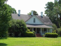 John P. Derham Houselisted 2005
Topographic sheets covering this place
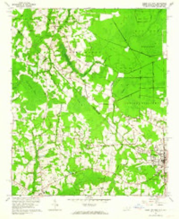
6 surveys from 9 printed sheetsMatched by testing this settlement's coordinate against the published boundary of every sheet in the United States Geological Survey's historical collection. Each opens the scanned sheet at the Survey.
- 1953 USGS Florence quadrangle1:250000, 3 printings
- 1954 USGS Florence quadrangle1:250000
- 1962 USGS Tabor City quadrangle1:62500
- 1962 USGS Tabor City West quadrangle1:24000, 2 printings
- 1986 USGS Whiteville quadrangle1:100000
- 1990 USGS Whiteville quadrangle1:100000
Fires near this place
220 since 1992Regional context, not property-specific evidence. The federal wildfire occurrence database lists 220 fires within 5 miles of Green Sea between 1992 and 2020, burning about 1,162 acres in total. 2 started naturally. 60 were recorded as arson. Distance is straight-line from the map coordinates, so a fire counted here may appear on a neighbouring settlement's page as well.
| Reported cause | Fires |
|---|---|
| Debris and open burning | 96 |
| Arson/incendiarism | 60 |
| Missing data/not specified/undetermined | 53 |
| Equipment and vehicle use | 5 |
| Natural | 2 |
| Misuse of fire by a minor | 2 |
| Smoking | 2 |
The most recent of them, most recent first, with the day each was reported and the service that recorded it.
| Date | Cause | Size | Reported by | Name on the report |
|---|---|---|---|---|
| 8 September 2007 | Debris and open burning | 1.0 acres | South Carolina Forestry Commission | not named |
| 4 September 2010 | Debris and open burning | 1.2 acres | South Carolina Forestry Commission | not named |
| 3 September 2010 | Debris and open burning | under an acre | South Carolina Forestry Commission | not named |
| 20 September 2010 | Arson/incendiarism | under an acre | South Carolina Forestry Commission | not named |
| 2 September 2007 | Debris and open burning | 4.0 acres | South Carolina Forestry Commission | not named |
| 2 September 2007 | Debris and open burning | under an acre | South Carolina Forestry Commission | not named |
| 18 September 2010 | Debris and open burning | under an acre | South Carolina Forestry Commission | not named |
| 11 September 2005 | Debris and open burning | 17 acres | South Carolina Forestry Commission | not named |
Settlements close enough to share some of these fires:
Storms near this place
24 since 1996Regional context, not property-specific evidence. The National Weather Service names Green Sea in 24 storm reports between 1996 and 2025: 11 hail, 8 thunderstorm wind, 3 flash flood, 1 funnel cloud. The reports record 1 death and 7 injuries. Each account below is quoted exactly as the forecast office filed it, from the NOAA Storm Events Database, and each date opens the federal record of that event.
| When | Event | Place named | Harm | What the report says |
|---|---|---|---|---|
| September 2018 | Flash Flood | Green Sea | 1 killed, $10,000 | Hwy 646 closed due to flooding. A man's vehicle was swept off the roadway and he drowned. |
| August 2007 | Thunderstorm Wind | Green Sea | 7 hurt, $1,000,000 | A storm survey concluded that the damage examined was the result of straight line winds. A north-south swath of damage was found crossing SC Highway 9 near Duford. Damage was mainly in the form of large snapped trees and peeled off metal roofing from sheds and barns. Damage was also scattered from just north of S.R. 9 from Mount Olive Church Road to Bay View Drive. Considerable damage occurred at Green Sea Floyds High School including minor roof damage, a downed light pole, damage to a tennis court fence, broken windows, several trees down and a well constructed football scoreboard was blown over. An 18 wheel tractor trailer was overturned on SC Highway 9. Winds were estimated between 60 and 90 mph. A small area of more concentrated damage occurred along Mount Olive Church Road between Billy MC Road and Fairview Highway. At this location, a mobile home was completely destroyed and seven occupants in this home suffered minor injuries and were taken to the local hospital. Large trees 3-4 ft diameter were snapped and uprooted. Wind speeds with this damage were estimated between 95 and 109 mph. Two firefighters were injured when their firetruck ran over a downed tree in the road. All of the damage observed was aligned from north-northwest to south-southeast. About 10,000 people lost power. |
| July 2017 | Flash Flood | Green Sea | $15,000 | Eighteen inches of water was reportedly flowing across Green Sea Rd. near the intersection with Fair Bluff Hwy. This stretch of roadway was reported impassable. |
| April 2024 | Thunderstorm Wind | Green Sea | $10,000 | Public reported large hail of unknown size that damaged vehicle windows. |
| August 2020 | Lightning | Green Sea | $5,000 | Lightning caused a tree and an outbuilding to catch fire in the 5300 Block of Hwy 9. |
| July 2016 | Thunderstorm Wind | Green Sea | $2,000 | Two trees were reported down near the intersection of Decatur Road and Audie Road. |
| June 2015 | Thunderstorm Wind | Green Sea | $1,000 | A tree was reportedly down on Mt. Zion Road. |
| May 2012 | Hail | Green Sea | $1,000 | Hail to the size of quarters was reported. The hail lasted for about 5 minutes. |
| June 2025 | Thunderstorm Wind | Green Sea | - | SC Highway Patrol reports tree down on Green Sea Rd near Church Rd. |
| April 2022 | Hail | Green Sea | - | Golf ball size hail near Loris, SC. |
| April 2022 | Hail | Green Sea | - | Golf ball to baseball sized hail produced minor damage to side of house between Loris and Green Sea, SC. |
| August 2021 | Thunderstorm Wind | Green Sea | - | Trees down in northern Horry County. |
| February 2020 | Flash Flood | Green Sea | - | EMS reported that four people and dogs were rescued from their residence, and were told not to return until the water recedes. |
| June 2008 | Hail | Green Sea | - | Hail the size of pennies was reported. |
| June 2007 | Thunderstorm Wind | Green Sea | - | Spotter estimated a wind gust to 60 mph in Duford. |
| May 2006 | Hail | Green Sea | - | Ping pong size hail accumulated to a depth of four inches. |
| July 2006 | Thunderstorm Wind | Green Sea | - | Numerous trees were blown down, blocking many roads, leading to road closures. |
| August 2005 | Funnel Cloud | Green Sea | - | Public reported a funnel cloud at Hwy 904 and Green Sea Road near the state line. Horry county emergency management investigated and found no damage. |
| May 2003 | Hail | Green Sea | - | 911 center reported half dollar size hail in Mt. Olive. |
| May 2001 | Hail | Green Sea | - | Nickel size hail was reported to have caused crop damage. The damage amount is unknown. |
| June 2000 | Hail | Green Sea | - | Spotter reported nickel size hail. |
| May 1999 | Hail | Green Sea | - | no account filed |
| May 1996 | Hail | Green Sea | - | no account filed |
| May 1996 | Hail | Green Sea | - | no account filed |
Nearest settlements
The eight closest, with where each one stands in the county. Distances are straight-line, computed from the Geographic Names Information System coordinates.
| Map | Place | Distance | Sheets |
|---|---|---|---|
| Finklea | 1.9 miles | 9 | |
| Mount Olive | 3.3 miles | 9 | |
| White Pond | 3.5 miles | 9 | |
| Princeville | 3.7 miles | 9 | |
| Jernigans Crossroads | 4.0 miles | 9 | |
| Playcards | 5.2 miles | 8 | |
| Live Oak | 5.2 miles | 9 | |
| Pleasant View | 5.2 miles | 8 |
Elsewhere
Matched on this settlement's Geographic Names Information System number rather than its name, so it cannot be a different place of the same name in another state.
| Wikipedia article on Green Sea | An encyclopaedic summary. Its text is share-alike, so it is linked here rather than copied. |
| Wikidata item Q5603187 | The structured record the population and elevation above come from. Public domain (CC0). |
Provenance
This settlement is recorded in the Geographic Names Information System as feature 1231343. The sheet list is computed by point-in-boundary test against the United States Geological Survey's historical topographic inventory. Both are works of the United States government and carry no copyright under 17 U.S.C. 105.
Wildfire. Short, Karen C. 2022. Spatial wildfire occurrence data for the United States, 1992-2020 [FPA_FOD_20221014]. 6th Edition. Fort Collins, CO: Forest Service Research Data Archive. https://doi.org/10.2737/RDS-2013-0009.6 Collected with United States Government funding and usable without additional permissions or fees.
Storms. NOAA National Centers for Environmental Information, Storm Events Database https://www.ncei.noaa.gov/stormevents/ A work of the United States government, no copyright under 17 U.S.C. 105. Narratives are quoted verbatim from the National Weather Service report and are not edited or summarised.