 Block
Van Wyck, South Carolina
13 topographic sheets cover this place, the earliest surveyed in 1941 and the latest in 1986. It stands in the Van Wyck census division. It lies in ZIP code area 29720. It stands on Todd Branch. The Survey maps it on the Van Wyck quadrangle. 848 people lived here at the 2020 count. It stands 505 feet above sea level.
Research this city
On record in Van Wyck
Buildings and businesses the archive holds for this place. Each opens its own page, with the source record it came from.
On the National Register 2 records
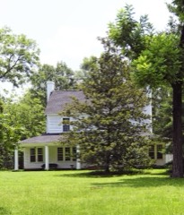 Massey-Doby-Nisbet Houselisted 1990
- Adam Ivy Houselisted 1990
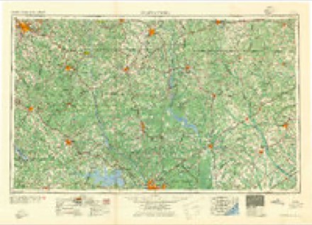
Topographic sheets covering this place
7 surveys from 13 printed sheetsMatched by testing this settlement's coordinate against the published boundary of every sheet in the United States Geological Survey's historical collection. Each opens the scanned sheet at the Survey.
- 1941 USGS Spartanburg quadrangle1:250000
- 1953 USGS Spartanburg quadrangle1:250000, 4 printings
- 1960 USGS Spartanburg quadrangle1:250000, 2 printings
- 1963 USGS Spartanburg quadrangle1:250000
- 1964 USGS Spartanburg quadrangle1:250000
- 1968 USGS Van Wyck quadrangle1:24000, 2 printings
- 1986 USGS Lancaster quadrangle1:100000, 2 printings
Fires near this place
112 since 1992Regional context, not property-specific evidence. The federal wildfire occurrence database lists 112 fires within 5 miles of Van Wyck between 1992 and 2020, burning about 505 acres in total. 2 started naturally. 3 were recorded as arson. Distance is straight-line from the map coordinates, so a fire counted here may appear on a neighbouring settlement's page as well.
| Reported cause | Fires |
|---|---|
| Missing data/not specified/undetermined | 47 |
| Debris and open burning | 39 |
| Equipment and vehicle use | 8 |
| Railroad operations and maintenance | 5 |
| Misuse of fire by a minor | 4 |
| Arson/incendiarism | 3 |
| Smoking | 3 |
| Natural | 2 |
| Recreation and ceremony | 1 |
The most recent of them, most recent first, with the day each was reported and the service that recorded it.
| Date | Cause | Size | Reported by | Name on the report |
|---|---|---|---|---|
| 29 September 2005 | Debris and open burning | under an acre | South Carolina Forestry Commission | not named |
| 28 September 1998 | Railroad operations and maintenance | 1.0 acres | South Carolina Forestry Commission | not named |
| 26 September 1996 | Missing data/not specified/undetermined | under an acre | South Carolina Forestry Commission | not named |
| 20 September 2011 | Debris and open burning | under an acre | South Carolina Forestry Commission | not named |
| 11 September 2005 | Debris and open burning | 1.0 acres | South Carolina Forestry Commission | not named |
| 4 August 2001 | Debris and open burning | 1.1 acres | South Carolina Forestry Commission | not named |
| 26 August 2009 | Missing data/not specified/undetermined | 8.0 acres | South Carolina Forestry Commission | not named |
| 26 August 2001 | Misuse of fire by a minor | 2.0 acres | South Carolina Forestry Commission | not named |
Settlements close enough to share some of these fires:
Mines and quarries near this place
10 of 12 shownRegional context, not property-specific evidence. The federal mineral resources record lists 12 workings within 5 miles of Van Wyck: 7 past producers, 3 unknowns, 2 producers. 2 still produce. What was taken out: Clay, Gold, Mica. Distance is straight-line from the map coordinates, so a quarry counted here may appear on a neighbouring settlement's page as well.
| Where | Site | Commodity | Status | Recorded |
|---|---|---|---|---|
| Sericite Pit Number 1 | Mica | Unknown | Metamorphic | |
| Gold Hill | Gold | Unknown | Vein | |
| Gold Hill Mine | Gold | Past Producer | ||
| Ashe Mine | Clay | Unknown | Sedimentary | |
| Ashe Mine | Clay | Past Producer | ||
| Faile Mine | Clay | Producer | ||
| John Barnette Mine | Clay | Past Producer | Unconsolidated Sediments | |
| Lancaster Mill | Clay | Past Producer | ||
| Van Wyck Mine | Clay | Past Producer | Sedimentary | |
| Van Wyck Mine | Clay | Producer |
Storms near this place
60 of 67 shownRegional context, not property-specific evidence. The National Weather Service names Van Wyck in 67 storm reports between 1999 and 2025: 33 thunderstorm wind, 23 hail, 10 flash flood, 1 flood. No death or injury is recorded in these reports. Each account below is quoted exactly as the forecast office filed it, from the NOAA Storm Events Database, and each date opens the federal record of that event.
| When | Event | Place named | Harm | What the report says |
|---|---|---|---|---|
| April 2011 | Hail | Van Wyck | $45,000 | Hail reported...bigger than quarter sized but small than golfball sized...at the Indian Land AMACO station. Also, several cars had broken windshields. |
| April 2011 | Hail | Van Wyck | $40,000 | County EM measured golfball size hail with dents covering his vehicle and others. |
| April 2011 | Hail | Van Wyck | $40,000 | Hail measuring 2 inches was reported at Andrew Jackson State Park. |
| April 2011 | Hail | Van Wyck | $40,000 | Public reported 2 inch hail. |
| June 2015 | Hail | Van Wyck | $18,000 | Police Officer reported golf ball size hail with trees and powerlines down on Harrisburg Road. |
| July 2012 | Thunderstorm Wind | Van Wyck | $8,000 | Sheriff reported trees and powerlines down in Indianland around Thousand Oak Road and in Black Horse Run. |
| September 2014 | Flash Flood | Van Wyck | $6,000 | DOT reported 1 to 2 feet of water from heavy rains closing several roads on the extreme north end of the county east of Ft. Mill. |
| January 2013 | Thunderstorm Wind | Van Wyck | $6,000 | Sheriff reported trees down along US 521 in the panhandle of Lancaster County. |
| July 2010 | Thunderstorm Wind | Van Wyck | $6,000 | Sheriff reported several trees down in the Van Wyck area. |
| July 2014 | Thunderstorm Wind | Van Wyck | $4,000 | Post Office reported large branches and several trees down in the north end of the county. |
| July 2012 | Thunderstorm Wind | Van Wyck | $3,000 | Van Wick Post Office reported trees down on Van Wyck Road 2 miles north of town. |
| January 2024 | Flash Flood | Van Wyck | $2,000 | Man O War Dr in Indian Land was flooded and impassable. Time estimated. |
| July 2015 | Thunderstorm Wind | Van Wyck | $2,000 | Highway Patrol reported trees down on Hwy 5 at Bon Rea Drive. |
| May 2014 | Thunderstorm Wind | Van Wyck | $2,000 | Sheriff reported power lines down in Indianland. Large hail also reported but size was unknown. |
| January 2024 | Flash Flood | Van Wyck | $1,000 | A small unnamed stream flooded, with water covering the roadway, on Calvin Hall Rd at Elven Dr. The road was impassable. Time estimated. |
| January 2024 | Flash Flood | Van Wyck | $1,000 | Pursuit Ln, near Indian Land, was flooded and impassable. Time estimated. |
| April 2015 | Thunderstorm Wind | Van Wyck | $1,000 | Public reported a couple of trees down in the Van Wyck area. |
| June 2011 | Thunderstorm Wind | Van Wyck | $1,000 | DOT reported a couple of trees down near Van Wyck along SR 5. |
| April 2016 | Flash Flood | Van Wyck | $500 | Man O War Drive was flooded and appeared impassable based on video posted on social media by broadcast media. Department of Highways also reported Straightaway Lane at Black Horse Run Road flooded with about 6 inches of water on the roadway. |
| October 2023 | Hail | Van Wyck | $100 | Spotter reported pea size hail at US Hwy 521 and Jim Wilson Rd. |
| May 2020 | Flood | Van Wyck | $100 | Lancaster Co dispatch reported water covering the roadway at Ander Vincent Rd near Waxhaw Hwy. Times estimated. |
| May 2020 | Hail | Van Wyck | $100 | Spotter reported pea size hail in Indian Land. |
| May 2019 | Hail | Van Wyck | $100 | Public reported penny size hail in the BridgeMill neighborhood. |
| September 2018 | Flash Flood | Van Wyck | $100 | Fort Mill Hwy (SC 160) at Calvin Hall Rd flooded and impassable. Times approximate. |
| September 2018 | Flash Flood | Van Wyck | $100 | Van Wyck Rd closed from Van Wyck city limits to Steel Hill Rd due to flooding. Duration unknown. Times approximate. |
| April 2016 | Flash Flood | Van Wyck | $100 | Lancaster County Dispatch reported flooding at Collins Rd and Hwy 521. The road was impassable. |
| March 2017 | Hail | Van Wyck | $10 | Pea to dime size hail reported in Indian Land. |
| June 2025 | Hail | Van Wyck | - | Estimated penny sized hail in Avondale Neighborhood in Indian Land. |
| June 2025 | Thunderstorm Wind | Van Wyck | - | Lancaster dispatch reported trees down at Barberville Rd at Harrisburg Rd. Time estimated by radar. |
| January 2024 | Thunderstorm Wind | Van Wyck | - | Trees were downed on Harrisburg Rd near Giles Ln, NW of Indian Land. Time estimated. |
| May 2024 | Thunderstorm Wind | Van Wyck | - | Several trees were downed along Shelley Mullis Rd near Indian Land. Time estimated. |
| August 2024 | Flash Flood | Van Wyck | - | Lancaster County Emergency Management confirmed Van Wyck Road is closed over Twelvemile Creek due to flooding. |
| August 2024 | Flash Flood | Van Wyck | - | Lancaster County Emergency Manager reported flooding across roadways in the Black Horse Run subdivision. |
| May 2022 | Hail | Van Wyck | - | Video posted on social media of penny sized hail falling in the yard in Indian Land. |
| August 2022 | Thunderstorm Wind | Van Wyck | - | Trees down on power lines near Reid Pointe Ave. Time estimated. |
| July 2022 | Thunderstorm Wind | Van Wyck | - | Highway Department had to clear a downed tree across Old Hickory Rd just south of West Rebound Rd. |
| June 2022 | Hail | Van Wyck | - | Hail up to golf ball size reported at Andrew Jackson State Park. Time estimated. |
| April 2020 | Thunderstorm Wind | Van Wyck | - | Reports of multiple trees and power lines down in Indian Land. Time estimated. |
| May 2019 | Thunderstorm Wind | Van Wyck | - | Public reported a tree down on a power line in the Black Horse Run neighborhood. |
| July 2018 | Thunderstorm Wind | Van Wyck | - | Power lines were downed on Horseshoe Circle and it led to a brush fire. Time estimated. |
| June 2018 | Thunderstorm Wind | Van Wyck | - | SCHP reported tree down in roadway on US Hwy 521 S about 2 miles south of intersection with SC 75. Time estimated. |
| February 2016 | Thunderstorm Wind | Van Wyck | - | Reported trees and power lines down across the northern portion of Lancaster County. |
| February 2016 | Thunderstorm Wind | Van Wyck | - | Ranger at Andrew Jackson State Park reported numerous small to large limbs down within the park. |
| March 2016 | Hail | Van Wyck | - | Multiple social media reports of nickel size hail in the Indian Land area of Lancaster County. |
| March 2016 | Hail | Van Wyck | - | Public reported quarter size hail at Kinross Lane near Carolina Reserve. They also reported strong winds that blew over trash cans and lasted for about 10 minutes. |
| April 2016 | Hail | Van Wyck | - | SKYWARN Spotter reported nickel sized hail on Whimbrel Circle. |
| July 2016 | Thunderstorm Wind | Van Wyck | - | Large limbs downed at Andrew Jackson State Park. One camper damaged. |
| July 2016 | Thunderstorm Wind | Van Wyck | - | Multiple trees down on Doby's Bridge Rd. |
| July 2016 | Thunderstorm Wind | Van Wyck | - | Trees down on Calvin Hall Rd and Harrisburg Rd. |
| May 2014 | Hail | Van Wyck | - | Spotter reported baseball size hail. |
| April 2012 | Hail | Van Wyck | - | Postal employee reported dime size hail in the Sun City/Carolina Lakes area. |
| May 2011 | Thunderstorm Wind | Van Wyck | - | Sheriff dispatch reported trees down in the Van Wyck community. |
| June 2011 | Hail | Van Wyck | - | Public reported nickel to quarter size hail on Smith and Marvin roads. |
| April 2011 | Hail | Van Wyck | - | Public reported nickel size hail 3.5 miles ENE of Fort Mill. |
| May 2009 | Thunderstorm Wind | Van Wyck | - | Tree down on car on Jim Wilson Rd. Trees down along Jim Wilson Rd. |
| July 2008 | Hail | Van Wyck | - | Penny size hail reported by Sheriff Dispatch in the Indian Land area of the county. |
| April 2007 | Hail | Van Wyck | - | Convenience store at Hwy 521 and Fort Mill Hwy reported nickel size hail. |
| June 2007 | Thunderstorm Wind | Van Wyck | - | Sheriff reported trees and powerlines down. |
| June 2004 | Thunderstorm Wind | Van Wyck | - | Post Office reported large branches down on hwy 75 between Van Wyck and Hancock. |
| July 2003 | Thunderstorm Wind | Van Wyck | - | Sheriff reported trees down in Hancock on hwy 521. |
Nearest settlements
The eight closest, with where each one stands in the county. Distances are straight-line, computed from the Geographic Names Information System coordinates.
| Map | Place | Distance | Sheets |
|---|---|---|---|
| Curetons (historical) | 2.9 miles | 13 | |
| Springdell | 3.0 miles | 12 | |
| Hancock | 3.9 miles | 15 | |
| Fosters Crossroads | 5.0 miles | 13 | |
| Riverside | 6.0 miles | 13 | |
| Shiloh | 6.5 miles | 13 | |
| Belair | 6.5 miles | 15 | |
| Quail Haven | 7.1 miles | 13 |
Elsewhere
Matched on this settlement's Geographic Names Information System number rather than its name, so it cannot be a different place of the same name in another state.
| Wikipedia article on Van Wyck | An encyclopaedic summary. Its text is share-alike, so it is linked here rather than copied. |
| Wikidata item Q7913782 | The structured record the population and elevation above come from. Public domain (CC0). |
Provenance
This settlement is recorded in the Geographic Names Information System as feature 1251287. The sheet list is computed by point-in-boundary test against the United States Geological Survey's historical topographic inventory. Both are works of the United States government and carry no copyright under 17 U.S.C. 105.
Wildfire. Short, Karen C. 2022. Spatial wildfire occurrence data for the United States, 1992-2020 [FPA_FOD_20221014]. 6th Edition. Fort Collins, CO: Forest Service Research Data Archive. https://doi.org/10.2737/RDS-2013-0009.6 Collected with United States Government funding and usable without additional permissions or fees.
Mines and quarries. USGS Mineral Resources Data System (MRDS) https://mrdata.usgs.gov/mrds/ A work of the United States government, no copyright under 17 U.S.C. 105.
Storms. NOAA National Centers for Environmental Information, Storm Events Database https://www.ncei.noaa.gov/stormevents/ A work of the United States government, no copyright under 17 U.S.C. 105. Narratives are quoted verbatim from the National Weather Service report and are not edited or summarised.