
BlockBefore
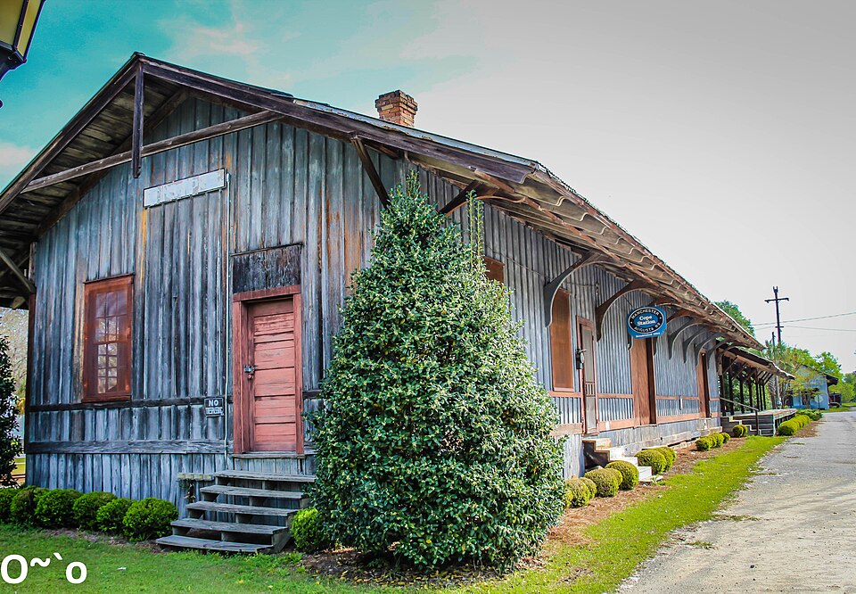
Photograph of Cope Depot
Photograph by Race2Beach - Sara Dean, CC BY-SA 4.0. Via Wikimedia Commons.

Cope Depot

Listed on the National Register of Historic Places in 2001.

From the record

“The Cope Depot, or Manchester and Augusta Railroad Station in Cope, South Carolina was a privately owned railroad depot built in 1893. It was built by the Manchester and Augusta Railroad six years before being acquired by the Atlantic Coast Line Railroad as part of their Florence - Robbins Line.”

Wikipedia article Cope station, CC BY-SA 4.0.

One of 42 National Register listings published here for Orangeburg County · listed in 2001 · category: Building.

Sources: the Wikipedia article · the case file at the National Archives · the National Register database, National Park Service

The listing

  • What is counted as historic. The nomination lists 1 building as contributing to the listing.
  • Address. Cope Rd., Cope, 29038
  • When was it listed? March 2001
  • Category. building
  • Census division. Cope
  • National Register reference number. 01000298 - the number the National Park Service assigned this property when it was listed, and the key its nomination file is catalogued under at the National Archives.

Fires near this property

197 since 1992

Regional context, not property-specific evidence. The federal wildfire occurrence database lists 197 fires within 5 miles of Cope Depot between 1992 and 2020, burning about 709 acres in total. 3 started naturally. 10 were recorded as arson. Distance is straight-line from the map coordinates, so a fire counted here may appear on a neighbouring settlement's page as well.

Reported cause Fires
Debris and open burning87
Missing data/not specified/undetermined68
Equipment and vehicle use14
Arson/incendiarism10
Smoking7
Misuse of fire by a minor6
Natural3
Recreation and ceremony2

The most recent of them, most recent first, with the day each was reported and the service that recorded it.

DateCause SizeReported by Name on the report
8 September 2011Debris and open burning2.0 acresSouth Carolina Forestry Commissionnot named
8 September 1997Debris and open burningunder an acreSouth Carolina Forestry Commissionnot named
3 September 2014Smokingunder an acreSouth Carolina Forestry Commissionnot named
21 September 2019Debris and open burning8.0 acresSouth Carolina Forestry Commissionnot named
26 August 2001Debris and open burning2.0 acresSouth Carolina Forestry Commissionnot named
23 August 2004Debris and open burning3.1 acresSouth Carolina Forestry Commissionnot named
23 August 2002Natural25 acresSouth Carolina Forestry Commissionnot named
22 August 2014Debris and open burningunder an acreSouth Carolina Forestry Commissionnot named

Every fire recorded in Orangeburg County

Storms near this property

35 since 1996

Regional context, not property-specific evidence. The National Weather Service names Cope, the town this property stands in, in 35 storm reports between 1996 and 2025: 25 thunderstorm wind, 5 hail, 3 tornado, 1 lightning. No death or injury is recorded in these reports. Each account below is quoted exactly as the forecast office filed it, from the NOAA Storm Events Database, and each date opens the federal record of that event.

WhenEvent Place namedHarm What the report says
July 1997LightningCope$300,000A lightning strike at the Cope Baptist Church caused the educational building to catch fire and burn down.
July 2012Thunderstorm WindCope$20,000Public reported numerous trees and powerlines down in and around Cope.
July 2012Thunderstorm WindCope$12,000Sheriff dispatch reported trees down in western Orangeburg county.
March 1996Tornado (F0)Cope$5,000no account filed
June 2011Thunderstorm WindCope$4,000Sheriff reported trees and powerlines down at Binncker Bridtg road and Cope road.
July 2015Thunderstorm WindCope$3,000Highway Patrol reported trees down on Hwy 70 at the Edisto River.
August 2011Thunderstorm WindCope$500Highway Patrol reported a tree in the roadway at Snake Swamp road and Hwy 301.
June 2025Thunderstorm WindCope-SC DPS website reported a tree down on Binnicker Bridge Road near the intersection of Good Hope Road. Time estimated by radar.
July 2025Thunderstorm WindCope-Orangeburg Dispatch reported a tree down near the intersection of Bamberg Rd and Slab Landing Rd. Time estimated by radar.
November 2024Flash FloodCope-Orangeburg County and SC state officials confirmed a breach of Eugene and Michele Miller dam. Binnicker Bridge Road washed out and closed as a result of the dam failure.
July 2023Thunderstorm WindCope-Edisto Electric Coop reported several trees down due to strong winds in an area from near the Canaan community, east to Rowesville and vicinity to Bowman and vicinity. Specific locations not given. Time estimated.
June 2019Thunderstorm WindCope-SCHP reported tree in roadway US Hwy 301 at SC 322. Time estimated.
July 2019Thunderstorm WindCope-NWS Damage Assessment Team determined that a downburst produced straight-line wind damage just south of the intersection of Binnicker Bridge Rd and Early Morning Rd, east of Roberts Swamp. Numerous trees were snapped and uprooted with a damage path length over 0.6 miles and path width of approximately 500 yards. In addition, panels were lifted off the corner of a metal roof and a small fiberglass boat was tossed over 30 yards before crashing into a wood post. Wind speeds were estimated at 85 to 95 MPH.
January 2017Tornado (EF1)Cope-The National Weather Service in Columbia has confirmed a tornado|near Cope in Orangeburg County South Carolina on January 21 2017|based on information provided by the Orangeburg County Emergency|Manager. The tornado touched down near Highway 70 near the |Orangeburg-Bamberg County line, then continued northeast across |Cope Road before dissipating near the intersection of Deer Trail |Road and Whisenhunt Road. Most of the damage observed along the |path was rated EF0, but the tornado did briefly strengthen into an|EF1 near the intersection of Highway 70 and Cope Road/Highway 332.|In this vicinity, three mobile homes were heavily damaged and a |metal farm building collapsed. Numerous trees were either snapped |or uprooted.
July 2016Thunderstorm WindCope-Dispatch reported trees down on Ember Road.
June 2014Thunderstorm WindCope-Public reported large limbs down and wind gusts estimated to be from 50 to 60 mph. They also reported pea size hail.
June 2014Thunderstorm WindCope-Public reported several limbs down and two large limbs down in Cope. They also reported dime size hail.
June 2014Thunderstorm WindCope-Public reported several limbs down, some large, along Binnicker Bridge Road. They also reported penny size hail.
March 2012Thunderstorm WindCope-Sheriff dispatch reported a tree down in the Canaan Community.
July 2012HailCope-Public reported nickel size hail near Cope along with windy conditions.
May 2011HailCope-Spotter reported nickel size hail in Cope.
July 2008Thunderstorm WindCope-Post Office reported trees down near Cope on secondary roads.
May 2008HailCope-Public reported half dollar size hail.
July 2004Thunderstorm WindCope-Highway dept. reported several trees down on hwy 301 between Cope and Orangeburg.
September 2004Tornado (F0)Cope-An F0 took down some trees along Cannon Bridge road.
September 2001Thunderstorm WindCope-Post Office reported trees down on powerlines south of Cope.
September 2001HailCope-Post Office reported 3/4 inch hail west southwest of Cope.
July 2000Thunderstorm WindCope-EPD reported trees and powerlines down in the Cope and Cannan area.
May 1999HailCope-Post Office reported nickel size hail.
August 1999Thunderstorm WindCope-Edisto Electric reported more trees and powerlines down with second storm.
August 1999Thunderstorm WindCope-Edisto Electric reported trees down in Canna Community area.
August 1999Thunderstorm WindCope-Sheriff reported trees down.
April 1997Thunderstorm WindCope-no account filed
May 1996Thunderstorm WindCope-no account filed
April 1996Thunderstorm WindCope-no account filed

Every storm recorded in Orangeburg County

Map coverage status

No historic map-sheet match is published for this property yet. That does not mean no map exists. This record needs a coordinate-quality review before it can be joined to a sheet boundary. Browse the county's mapped places while that work is pending.

Sources for this property

National Archives recordThe nomination case file for reference 01000298 in Record Group 79.
Wikipedia articleCommunity-written account of this property, licensed CC BY-SA.
Orangeburg CountyAll 42 listed properties in this county.

Provenance

  • Listing record. National Park Service National Register of Historic Places, listed-properties dataset, current to 2026-05-22.
  • Map join. Address geocoded through the United States Census geocoder, then tested against the published boundary of every sheet in the USGS Historical Topographic Map Collection.
  • How this page is made. Listing fields come from federal records; map-sheet coverage is a labelled coordinate-to-boundary calculation, not a source-field claim.
  • Wildfire. Short, Karen C. 2022. Spatial wildfire occurrence data for the United States, 1992-2020 [FPA_FOD_20221014]. 6th Edition. Fort Collins, CO: Forest Service Research Data Archive. https://doi.org/10.2737/RDS-2013-0009.6 Collected with United States Government funding and usable without additional permissions or fees.
  • Storms. NOAA National Centers for Environmental Information, Storm Events Database https://www.ncei.noaa.gov/stormevents/ A work of the United States government, no copyright under 17 U.S.C. 105. Narratives are quoted verbatim from the National Weather Service report and are not edited or summarised.