 Block
From the record
One of 181 National Register listings published here for Richland County · listed in 2017 · category: Building · built in 1946.
Sources: the National Register database, National Park Service
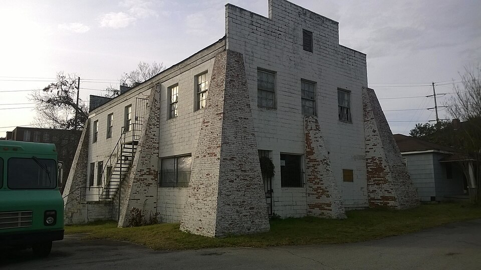
Built in 1946. Listed on the National Register of Historic Places in 2017.
One of 181 National Register listings published here for Richland County · listed in 2017 · category: Building · built in 1946.
Sources: the National Register database, National Park Service
Regional context, not property-specific evidence. The federal wildfire occurrence database lists 129 fires within 5 miles of Olympia Union Hall between 1992 and 2019, burning about 521 acres in total. 1 started naturally. 11 were recorded as arson. Distance is straight-line from the map coordinates, so a fire counted here may appear on a neighbouring settlement's page as well.
| Reported cause | Fires |
|---|---|
| Missing data/not specified/undetermined | 59 |
| Misuse of fire by a minor | 26 |
| Arson/incendiarism | 11 |
| Recreation and ceremony | 8 |
| Equipment and vehicle use | 6 |
| Debris and open burning | 5 |
| Power generation/transmission/distribution | 4 |
| Smoking | 3 |
| Railroad operations and maintenance | 3 |
| Fireworks | 2 |
| Natural | 1 |
| Other causes | 1 |
The most recent of them, most recent first, with the day each was reported and the service that recorded it.
| Date | Cause | Size | Reported by | Name on the report |
|---|---|---|---|---|
| 25 September 2019 | Recreation and ceremony | 1.5 acres | South Carolina Forestry Commission | not named |
| 23 September 2010 | Misuse of fire by a minor | 1.5 acres | South Carolina Forestry Commission | not named |
| 10 September 1999 | Natural | under an acre | South Carolina Forestry Commission | not named |
| 5 August 1993 | Missing data/not specified/undetermined | 1.0 acres | South Carolina Forestry Commission | not named |
| 31 August 1999 | Arson/incendiarism | 2.0 acres | South Carolina Forestry Commission | not named |
| 27 August 2011 | Arson/incendiarism | under an acre | South Carolina Forestry Commission | not named |
| 24 August 2004 | Railroad operations and maintenance | under an acre | South Carolina Forestry Commission | not named |
| 24 August 1993 | Missing data/not specified/undetermined | under an acre | South Carolina Forestry Commission | not named |
Regional context, not property-specific evidence. The federal mineral resources record lists 13 workings within 5 miles of Olympia Union Hall: 5 producers, 5 past producers, 3 unknowns. 5 still produce. What was taken out: Clay, Granite, Stone, Crushed/Broken, Zirconium, Thorium, Titanium, Iron, Stone, Crushed/Broken. Distance is straight-line from the map coordinates, so a quarry counted here may appear on a neighbouring settlement's page as well.
| Where | Site | Commodity | Status | Recorded |
|---|---|---|---|---|
| Cayce Quarry | Stone, Crushed/Broken | Producer | ||
| Cayce Silica Plant | Silica | Unknown | ||
| Congaree River | Zirconium, Thorium, Titanium, Iron | Unknown | Placer , Modern , Fluvial | |
| Green Hole | Stone, Crushed/Broken, Stone, Dimension, Granite | Past Producer | Igneous | |
| Guignard Mill | Clay, Kaolin | Past Producer | ||
| Westinghouse Elec. Corp--Columbia | Thorium | Unknown | ||
| Cayce Quarry | Granite, Stone, Crushed/Broken | Producer | 1893 | |
| Columbia Quarry | Granite, Stone, Crushed/Broken | Producer | 1883 | |
| Duncan Lakes Mine | Clay | Producer | ||
| Laborde Pit | Clay | Producer |
Regional context, not property-specific evidence. The National Weather Service names Columbia, the town this property stands in, in 293 storm reports between 1994 and 2025: 146 thunderstorm wind, 72 flash flood, 44 hail, 14 heavy rain. The reports record 10 injuries. Each account below is quoted exactly as the forecast office filed it, from the NOAA Storm Events Database, and each date opens the federal record of that event.
| When | Event | Place named | Harm | What the report says |
|---|---|---|---|---|
| June 2011 | Lightning | Columbia | 5 hurt | A midafternoon thunderstorm produced lightning that struck an Oak tree at Allen Benedict Court on Harden Street where 5 landscape and maintenance workers were sitting. One worker was taken to the hospital with non-life threatening injuries. The others were treated and released. |
| April 1999 | Lightning | Columbia | 3 hurt | Three people were hit by lightning at River Banks Zoo. The victims were taken to nearby hospitals and released the next day. |
| July 1997 | Tornado (F1) | Columbia | 1 hurt, $205,000 | An F1 tornado produced winds to 100 mph. Numerous trees were down and 35 homes had minor damage. Seventeen businesses also had minor damage. One person was injured. |
| May 1997 | Thunderstorm Wind | Columbia | 1 hurt, $20,000 | no account filed |
| June 2006 | Lightning | Columbia | $1,500,000 | Lightning struck a tree and ran through the ground into the home starting a fire in the home in the Woodcreek Farms Subdivision. |
| August 2016 | Heavy Rain | Columbia | $1,000,000 | Richland County Emergency Services automated rain gauge in MLK Park reported 3.46 inches of rain in 44 minutes from 7:15 PM to 7:59 PM EST. |
| July 2013 | Thunderstorm Wind | Columbia | $820,000 | The State Newspaper reported several trees fell on homes in Columbia. At least 8 homes were damaged so thoroughly that they were deemed unsafe for habitation. |
| June 2009 | Lightning | Columbia | $500,000 | Lightning struck a home at 38 Shoreline Drive and ignited a fire which destroyed it. |
| August 2005 | Lightning | Columbia | $300,000 | Lightning caused a home fire at 204 Upland Trail that caused $300k worth of damage. |
| June 2009 | Lightning | Columbia | $220,000 | Lightning struck a home and ingited a fire which destroyed it. The home was located at 150 Rivendale Drive. |
| August 2015 | Thunderstorm Wind | Columbia | $210,000 | DOT and broadcast media reported numerous trees down and powerlines down on the southeast, east, and northeast side of Columbia. Some trees fell on homes and vehicles causing significant damage. |
| July 2003 | Lightning | Columbia | $175,000 | Lightning struck a home in Spring Valley at 411 Bridgecrest Drive and caused $175,000 in damage. |
| June 2015 | Flash Flood | Columbia | $120,000 | USGS river guage at Rocky Branch Creek measured 11.3 feet with 2 to 4 feet of water flooding the area around Main and Whaley Streets and also in Five Points near the Walgreens. Water also got into several homes and apartments causing damage to the lower levels. |
| September 2011 | Heavy Rain | Columbia | $120,000 | The observer at USC reported 3.24 Inches of rain fell in just an hour at the University of South Carolina rain gage. |
| July 2022 | Flash Flood | Columbia | $100,000 | USGS Rocky Branch at Whaley St gage rose above flood stage, cresting at 12.90 feet at 6:27PM, exceeding the previous max crest. The Five Points area in Columbia had the most significant flooding with multiple vehicles submerged requiring multiple rescues. Water also entered apartments in the St. Andrews area. A mesonet site at MLK Park reported 4.09 inches of rain in one hour. |
| September 2011 | Flash Flood | Columbia | $80,000 | Numerous reports of flooding and road closures throughout the City of Columbia. |
| February 2003 | Lightning | Columbia | $70,000 | A home was struck by lightning that caused a fire resulting in $70,000 worth of damage. |
| June 2003 | Lightning | Columbia | $55,000 | Lightning struck a home starting a fire that caused $55k in damage. |
| June 2007 | Flash Flood | Columbia | $50,000 | Several inches of rain fell in a two hour period that sent Rock Creek over its bank flooding the five points area and stranding several motorists in their vehicles. One had to be rescued that was trapped in his car. |
| June 2011 | Thunderstorm Wind | Columbia | $45,000 | The State also reported that part of a roof was torn off a USC building and damage to other buildings and vehicles. This was also reported through Charleston NWS, a pilot reported part of a room torn off at a building along Huger Street. |
| August 2011 | Flash Flood | Columbia | $44,000 | Heavy rains from training thunderstorms produced flash flooding in downtown Columbia in the Maxcy Park, Five Points, and USC areas. Water levels rose to as high as 4 to 6 feet in some areas submerging a few vehicles. |
| September 2011 | Flash Flood | Columbia | $35,000 | Reported multiple areas of flooding with several cars stuck in high water in downtown Columbia. Sewers were overflowing in the Rosewood Community. Minor flooding was reported in the 5 Pts. Area. Flooding also occurred along Rocky Branch Creek especially at the intersection of Whaley and Main Streets. Rocky Branch Creek crested at 9.2 ft. at Pickens St. and 10.5 ft. at Whaley St.. In approximately 90 minutes...3.13 inches of rain fell at Owens Field...2.24 inches fell at the NWS rain gauge at USC. |
| September 2014 | Flash Flood | Columbia | $32,000 | Heavy rains produced flash flooding at Main and Whaley Streets, around the fair grounds, and on Rosewood just east of Assembly street. Water levels rose to 4 feet flooding several vehicles. |
| June 2011 | Thunderstorm Wind | Columbia | $30,000 | Trees diwb at the Governors Mansion. One tree fell and crushed a vehicle. |
| September 2008 | Flash Flood | Columbia | $30,000 | Police reported roads closed from flash flooding at Elmwood and Bull streets, Olympia Ave. and Bluff road, Whaley and Main streets, with a couple of vehicles trapped in those locations. There were no injuries and no rescues were needed. |
| June 2003 | Thunderstorm Wind | Columbia | $30,000 | Trees fell on a home in Columbia causing moderate damage to the roof. WOLO TV studio had part of the roof and side of the building torn off. |
| July 2010 | Thunderstorm Wind | Columbia | $28,000 | Sheriff reported trees down from Percival road at Smallwood Court to Screaming Eagle and Kelly Mill roads. A tree also fell on a car at Claremont and Kilbourne roads crushing it. |
| August 2016 | Flash Flood | Columbia | $25,000 | Media reported flash flooding occurring in the Rocky Branch Creek Watershed, Five Points area and at Main and Whaley Streets. Water entering Walgreen's Pharmacy at 1941 Blossom Street. |
| September 2011 | Flash Flood | Columbia | $24,000 | River gage along the Rocky Branch Creek near Blossom and Piclens streets crested at 12.2 feet. Flood stage is 7.2 feet. Several cars were under water and a few people had to be rescued. |
| August 2010 | Flash Flood | Columbia | $22,000 | USGS and City Police reported flooding in downtown Columbia in the Five Points area and also the USC campus near Main and Whaley streets. Water levels were up to 4 feet deep in some areas and spilled over into some apartments and also Walgreens in Five Points. The Rocky Branch Creek gage crested at 10.7 feet which is 3.5 feet above flood stage. Several vehicles became trapped when they tried to drive through the area. |
| July 1997 | Thunderstorm Wind | Columbia | $22,000 | A severe thunderstorm blew down a couple of trees on homes on Murray Street causing some damage. |
| September 2011 | Thunderstorm Wind | Columbia | $20,000 | Numerous reports of trees down throughout the City of Columbia. |
| August 2011 | Flash Flood | Columbia | $20,000 | Columbia Police reported multiple roads and intersections flooded and closed due to high water levels of 2 to 5 feet. These included Main and Whaley, Gervais and Laurens, Santee and Harden, and Rosewood and Assembly. A vehicle was submerged at Key Road and George Rogers Blvd. The gage at Pickens St. on the Rocky Branch Creek reached 8.7 ft. Flood stage is 7.2 ft. |
| August 2008 | Flash Flood | Columbia | $20,000 | Sheriff and public reported flash flooding across several roads with water up to 3 feet deep closing roadways. Some vehicles were stalled but no occupants were trapped. Spotters reported 2 to 4 inches of rain within a 1 to 2 hour period from the remnants of Tropical Storm Fay. |
| September 2015 | Flash Flood | Columbia | $18,000 | Columbia Police reported flooding at the intersection of Main and Whaley trapping a car. The occupants escaped before the flood waters rose to 4 feet above the roads. |
| May 2011 | Thunderstorm Wind | Columbia | $16,000 | Sheriff reported trees down at Victoria and Wallace streets. One was on a vehicle. Time estimated from radar. |
| May 2009 | Flash Flood | Columbia | $16,000 | Police and city officials reported flash flooding in the Five Points area. Several vehicles were stranded in 2 to 4 feet of water. |
| May 1995 | Thunderstorm Wind | East Columbia | $15,000 | no account filed |
| August 2015 | Flash Flood | Columbia | $14,000 | Water rescue by Columbia Fire Dept. for two motorists trapped in flood waters. Water levels were 4 feet deep. Vehicle stalled as they tried to drive through the flooded area. |
| August 2014 | Flash Flood | Columbia | $14,000 | Public reported a vehicle flooded at the intersection of Main and Whaley Streets with water 4 feet above the road covering the hood of the vehicle. Four occupants had to be rescued with no injuries. |
| June 2010 | Thunderstorm Wind | Columbia | $14,000 | WIS TV reported a couple of trees down on a home in the Shandon subdivision of Columbia. |
| July 2010 | Flash Flood | Columbia | $12,000 | USGS reported flash flooding in downtown Columbia along Rocky Creek where the gage was 3 feet over flood stage. Around 2 inches of rain fell within an hour. |
| June 2022 | Flash Flood | Columbia | $10,000 | The ground floor of a building at Canalside Lofts was flooded. |
| June 1995 | Thunderstorm Wind | Columbia | $10,000 | Thunderstorm winds blew off large limbs in the Columbia/West Columbia area; also, winds downed trees and powerlines in Swansea. |
| July 2013 | Thunderstorm Wind | Columbia | $8,000 | SCE&G reported trees and powerlines down around Richland County with power outages. |
| May 2012 | Thunderstorm Wind | Columbia | $8,000 | The State newspaper reported several trees down in the city. |
| June 2010 | Thunderstorm Wind | Columbia | $8,000 | Sheriff reported trees down McGraw and McCords Ferry roads. |
| September 2011 | Thunderstorm Wind | Columbia | $6,000 | Police reported trees down on Saluda Rivers road and Leesburg road. |
| August 2025 | Flash Flood | Columbia | $5,000 | Columbia Fire Dept reports a flooded vehicle with water rescue operations at the 900 block of Gadsden St. |
| June 2025 | Flash Flood | Columbia | $5,000 | EM reported flooded vehicle floating in flood waters at Gervais near the train trestle. |
| June 2022 | Lightning | Columbia | $5,000 | A structure fire due to lightning at 1031 Price Ave. Extent of damage unknown. |
| June 2022 | Flash Flood | Columbia | $5,000 | An apartment was flooded at 1015 Assembly St. |
| December 2015 | Flash Flood | Columbia | $5,000 | Local media reported flooding in the Five Points area along Blossom Street. |
| September 2011 | Flash Flood | Columbia | $5,000 | Flooding occurred along Rocky Branch Creek. The gauge at Pickens St. crested at 9.5 ft. and the gauge at Whaley St. crested at 10.5 ft. Flooding occurred in the 5 Pts area especially in the vicinity of Walgreens. Flooding also occurred at the intersection of Whaley St. and Main St. where the roadway was impassable. |
| May 2010 | Flash Flood | Columbia | $5,000 | Public reported flash flood along Rocky Branch creek in the Whaley Mill area of downtown Columbia. Water rose to the bottom of vehicles. |
| June 2008 | Thunderstorm Wind | Columbia | $5,000 | Spotter reported a couple of trees down on a home on Chavis St. Only minor damage was reported. |
| September 2008 | Flash Flood | Columbia | $5,000 | Police reported flooding in downtown Columbia near USC and in the Five Points area closing several roads. Water was 1 to 3 feet deep. |
| November 2014 | Thunderstorm Wind | Columbia | $4,000 | Richland County Dispatch reported power lines and traffic lights down in downtown Columbia at the intersection of Maple and Blossom Streets. |
| May 2014 | Thunderstorm Wind | Columbia | $4,000 | DOT reported several trees down on the south side of Columbia. |
| August 2014 | Flash Flood | Columbia | $4,000 | Flooding occurred along Rocky Branch Creek from the intersection of Blossom Street and Pickens Street downstream to the intersection of Whaley Street and Main Street. The gauge near Pickens street crested at 9.07 feet at 530 pm EDT. The gauge near Whaley Street crested at 9.89 feet at 546 pm EDT. Flood stage at both gauges is 7.2 feet. |
10 papers published in this town, digitised by the Library of Congress and free to read: 10,596 issues, 82,333 pages. Every page is searchable, so a name or a street can be looked for directly in what the town printed about itself at the time.
| Newspaper | Published |
|---|---|
| South Carolina Temperance Advocate and Register of Agriculture and General Literature | 1841 to 1851 |
| South-Carolina Temperance Advocate | 1839 to 1841 |
| Tri-Weekly Phoenix | 1865 to 1875 |
| Columbia Phoenix | 1865 |
| The Columbia Daily Phoenix | 1865 |
| The Daily Phoenix | 1865 to 1878 |
| Straight-Out Democrat | 1878 to 1879 |
| The People's Recorder | 1893 to 1925 |
| The Southern Indicator | 1903 to 1925 |
| Columbia Phoenix | 1865 |
No historic map-sheet match is published for this property yet. That does not mean no map exists. This record needs a coordinate-quality review before it can be joined to a sheet boundary. Browse the county's mapped places while that work is pending.
Other National Register properties close enough to walk or drive between, ordered by distance from this one. Both positions come from the same geocoding pass that matched these properties to their map sheets.
| Photograph | Property | Distance | Listed |
|---|---|---|---|
 | Olympia Mill | 0.1 miles | 2005 |
 | Granby Mill Village Historic District | 0.3 miles | 1993 |
| Olympia Mill Village Historic District | 0.4 miles | 2018 | |
 | Richland Cotton Mill | 0.5 miles | 1983 |
 | Olympia Mill School | 0.5 miles | 2018 |
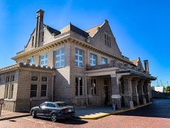 | Union Station | 0.6 miles | 1973 |
| National Archives record | The nomination case file for reference 100000571 in Record Group 79. |
| Richland County | All 181 listed properties in this county. |