 Block
From the record
One of 26 National Register listings published here for Laurens County · listed in 2025 · category: District.
Sources: the National Register database, National Park Service
Listed on the National Register of Historic Places in 2025.
One of 26 National Register listings published here for Laurens County · listed in 2025 · category: District.
Sources: the National Register database, National Park Service
Regional context, not property-specific evidence. The federal wildfire occurrence database lists 148 fires within 5 miles of Owings Historic District between 1992 and 2019, burning about 418 acres in total. 3 started naturally. 12 were recorded as arson. Distance is straight-line from the map coordinates, so a fire counted here may appear on a neighbouring settlement's page as well.
| Reported cause | Fires |
|---|---|
| Missing data/not specified/undetermined | 56 |
| Debris and open burning | 51 |
| Arson/incendiarism | 12 |
| Equipment and vehicle use | 9 |
| Misuse of fire by a minor | 9 |
| Railroad operations and maintenance | 3 |
| Natural | 3 |
| Smoking | 2 |
| Power generation/transmission/distribution | 2 |
| Recreation and ceremony | 1 |
The most recent of them, most recent first, with the day each was reported and the service that recorded it.
| Date | Cause | Size | Reported by | Name on the report |
|---|---|---|---|---|
| 7 September 2016 | Missing data/not specified/undetermined | under an acre | South Carolina Forestry Commission | not named |
| 4 September 2007 | Equipment and vehicle use | 5.0 acres | South Carolina Forestry Commission | not named |
| 23 September 2005 | Debris and open burning | under an acre | South Carolina Forestry Commission | not named |
| 23 September 1993 | Missing data/not specified/undetermined | 1.0 acres | South Carolina Forestry Commission | not named |
| 18 September 2010 | Debris and open burning | 1.3 acres | South Carolina Forestry Commission | not named |
| 17 September 2011 | Equipment and vehicle use | 1.6 acres | South Carolina Forestry Commission | not named |
| 16 September 2019 | Power generation/transmission/distribution | 2.5 acres | South Carolina Forestry Commission | not named |
| 16 September 2010 | Debris and open burning | 3.0 acres | South Carolina Forestry Commission | not named |
Regional context, not property-specific evidence. The federal mineral resources record lists 3 workings within 5 miles of Owings Historic District: 2 producers, 1 unknown. 2 still produce. What was taken out: Granite, Stone, Crushed/Broken, Stone, Crushed/Broken. Distance is straight-line from the map coordinates, so a quarry counted here may appear on a neighbouring settlement's page as well.
| Where | Site | Commodity | Status | Recorded |
|---|---|---|---|---|
| Gray Court #246 Quarry | Stone, Crushed/Broken | Producer | ||
| Entrekin Quarry | Granite, Stone, Crushed/Broken | Unknown | 1908 | |
| Gray Court Quarry | Granite, Stone, Crushed/Broken | Producer | Metamorphosed Igneous Intrusion |
Regional context, not property-specific evidence. The National Weather Service names Owings, the town this property stands in, in 11 storm reports between 2009 and 2022: 6 thunderstorm wind, 3 tornado, 1 hail, 1 flood. The reports record 1 death. Each account below is quoted exactly as the forecast office filed it, from the NOAA Storm Events Database, and each date opens the federal record of that event.
| When | Event | Place named | Harm | What the report says |
|---|---|---|---|---|
| June 2009 | Thunderstorm Wind | Owings | 1 killed, $1,240,000 | NWS survey found an area of extensive straight line wind damage. The damage began near Gray Court, but winds intensified significantly along West Main St in the city of Laurens, mainly in areas from Todd Ave to Laurens High School. Hundreds of trees were snapped off or uprooted. A 29-year-old woman was killed on highway 321 south of the city when a tree fell on her vehicle. Numerous trees fell on homes, causing roof damage. Other trees fell on and destroyed automobiles and outbuildings. For the most part, damage caused directly by the wind was minor. However, a detached garage at the intersection of highway 76 and Stagecoach Rd had its roof blown off, causing two of the walls to collapse. Another small structure was destroyed on LC Drive. |
| November 2010 | Tornado (EF1) | Owings | $50,000 | This tornado touched down along Wynfield Court north of Gray Court and moved along an intermittent path in a north northeast direction. Some trees were snapped and an outbuilding overturned near the beginning of the damage path. The tornado skipped to Robert Harris Ct, tearing the underskirting off a mobile home. Damage intensified toward Bramlett Church Rd, where a mobile home was moved from its foundation and had some siding and underskirting removed. Some shingles were torn off homes on Harris Bridge Rd, while the roofs of a well house and storage shed were blown off as well. The tornado lifted near Christmastree Lane, where several large oak trees were uprooted, one of which fell on and damaged a home. Also, a detached garage was completely destroyed at this location. |
| June 2020 | Tornado (EF0) | Owings | $10,000 | NWS storm survey found the path of a brief weak tornado just southwest of Perrin Circle in Laurens County. Residents described a wispy funnel that first touched down in a field damaged a carport and uprooted several trees as it moved into a wooded area. The weak tornado intermittently touched down and lifted along its half mile track downing a few more trees and snapping large branches before lifting just short of Cooley Road. Some minor damage occurred to an old barn as well as minor structural damage to a couple of houses. |
| August 2016 | Thunderstorm Wind | Owings | $5,000 | County comms reported part of the roof off a house, and a few trees and power lines blown on Thompson Rd near the intersection with Reedy Creek Rd. |
| November 2015 | Flood | Owings | $5,000 | After more than 4 inches of rain fell in about 36 hours, with much of that falling on the morning of the 2nd, county comms reported flooding developed across much of Laurens County. Multiple roads were closed, especially in the Gray Court, Waterloo, and Clinton areas. |
| May 2022 | Thunderstorm Wind | Owings | - | Ham radio operator reported multiple trees blown down. |
| August 2021 | Tornado (EF0) | Owings | - | Although an NWS storm survey could not find any physical evidence of damage, video posted on Social Media revealed a small vortex clearly in touch with the ground and lifting debris into the area crossing I-385 between Thompson Rd and Harmony Church Rd. |
| August 2020 | Thunderstorm Wind | Owings | - | County comms reported trees blown down at the intersection of Wham Lawn Rd and Tractor Dr. |
| April 2011 | Thunderstorm Wind | Owings | - | Numerous trees blown down across the county, with the Clinton area being the hardest hit. |
| May 2011 | Hail | Owings | - | Quarter size hail fell along highway 14, north of Gray Court. |
| May 2009 | Thunderstorm Wind | Owings | - | Trees were blown down on Thompson Rd and another tree was downed on Stewart Rd. |
No historic map-sheet match is published for this property yet. That does not mean no map exists. This record needs a coordinate-quality review before it can be joined to a sheet boundary. Browse the county's mapped places while that work is pending.
Other National Register properties close enough to walk or drive between, ordered by distance from this one. Both positions come from the same geocoding pass that matched these properties to their map sheets.
| Photograph | Property | Distance | Listed |
|---|---|---|---|
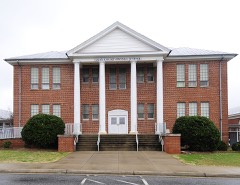 | Gray Court-Owings School | 1.0 miles | 2004 |
| Gray Court Downtown Historic District | 2.0 miles | 2024 |
| National Archives record | The nomination case file for reference 100012281 in Record Group 79. |
| Laurens County | All 26 listed properties in this county. |