
BlockBefore
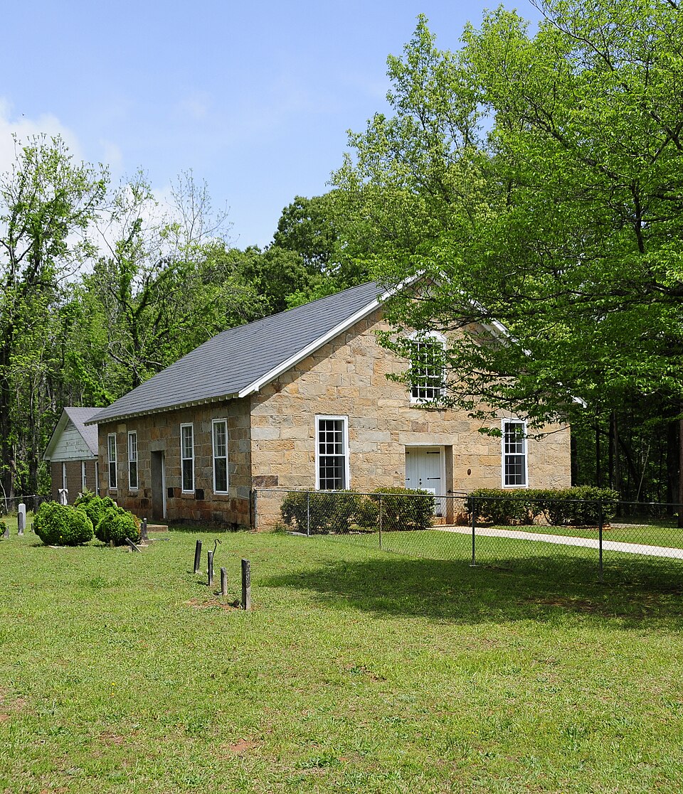
Photograph of Duncan's Creek Presbyterian Church
Photograph by Bill Fitzpatrick, CC BY-SA 3.0. Via Wikimedia Commons.

Duncan's Creek Presbyterian Church

Listed on the National Register of Historic Places in 1973.

From the record

“Duncan Creek Presbyterian Church, also known as Old Rock Church, is a historic Presbyterian church located near Clinton, Laurens County, South Carolina. It was built in 1842 and is a simple rectangular building constructed of irregular stones.”

Wikipedia article Duncan's Creek Presbyterian Church, CC BY-SA 4.0.

One of 26 National Register listings published here for Laurens County · listed in 1973 · category: Building.

Sources: the Wikipedia article · the case file at the National Archives · the National Register database, National Park Service · the Wikipedia article

The listing

  • What is counted as historic. The nomination lists 1 building, 1 site as contributing to the listing.
  • Address. 5 mi. NE of Clinton, off SC 72, Clinton, 29325
  • When was it listed? November 1973
  • Category. building
  • Census division. Clinton
  • National Register reference number. 73001714 - the number the National Park Service assigned this property when it was listed, and the key its nomination file is catalogued under at the National Archives.

Fires near this property

77 since 1992

Regional context, not property-specific evidence. The federal wildfire occurrence database lists 77 fires within 5 miles of Duncan's Creek Presbyterian Church between 1992 and 2019, burning about 347 acres in total. 5 started naturally. 9 were recorded as arson. Distance is straight-line from the map coordinates, so a fire counted here may appear on a neighbouring settlement's page as well.

Reported cause Fires
Missing data/not specified/undetermined39
Debris and open burning9
Arson/incendiarism9
Equipment and vehicle use6
Natural5
Power generation/transmission/distribution2
Recreation and ceremony2
Smoking2
Other causes1
Misuse of fire by a minor1
Railroad operations and maintenance1

The most recent of them, most recent first, with the day each was reported and the service that recorded it.

DateCause SizeReported by Name on the report
6 September 2003Recreation and ceremonyunder an acreSouth Carolina Forestry Commissionnot named
23 September 1999Arson/incendiarism1.0 acresSouth Carolina Forestry Commissionnot named
17 September 2010Debris and open burningunder an acreSouth Carolina Forestry Commissionnot named
28 August 1997Debris and open burningunder an acreSouth Carolina Forestry Commissionnot named
23 August 2007Arson/incendiarism25 acresSouth Carolina Forestry Commissionnot named
13 August 2007Equipment and vehicle useunder an acreSouth Carolina Forestry Commissionnot named
9 July 1993Missing data/not specified/undetermined3.0 acresSouth Carolina Forestry Commissionnot named
24 July 1995Missing data/not specified/undetermined3.0 acresSouth Carolina Forestry Commissionnot named

Every fire recorded in Laurens County

Mines and quarries near this property

2 within 5 miles

Regional context, not property-specific evidence. The federal mineral resources record lists 2 workings within 5 miles of Duncan's Creek Presbyterian Church: 1 past producer, 1 producer. 1 still produces. What was taken out: Vermiculite. Distance is straight-line from the map coordinates, so a quarry counted here may appear on a neighbouring settlement's page as well.

Where SiteCommodity StatusRecorded
Henry Estate MineVermiculitePast ProducerMetamorphosed Igneous Intrusion
Laurens County MinesVermiculiteProducer

Every working recorded in Laurens County

Storms near this property

53 since 1993

Regional context, not property-specific evidence. The National Weather Service names Clinton, the town this property stands in, in 53 storm reports between 1993 and 2024: 35 thunderstorm wind, 16 hail, 2 lightning. The reports record 1 injury. Each account below is quoted exactly as the forecast office filed it, from the NOAA Storm Events Database, and each date opens the federal record of that event.

WhenEvent Place namedHarm What the report says
July 2006Thunderstorm WindClinton1 hurtNumerous trees down from the Hurricane Church Rd area to along I-26 near the highway 66 exit. Several trees fell on the interstate, requiring closure of the east-bound lane for a while. One tree fell on a car, causing minor injuries to an occupant.
August 2002Thunderstorm WindClinton$50,000Numerous trees were blown down in the south part of town. Some trees fell on vehicles and buildings.
April 1996LightningClinton$9,000no account filed
April 1997Thunderstorm WindClinton$5,000no account filed
September 2003Thunderstorm WindClinton$1,000Two trees were blown down on Bond Street. Power lines were knocked down as the trees fell.
January 2024Thunderstorm WindClinton-Public reported (via Social Media) trees blown down in the Clinton area.
August 2020Thunderstorm WindClinton-Law enforcement reported a couple of trees blown down.
March 2017HailClinton-The NWS in Columbia relayed a media report of golf ball size hail in Clinton.
July 2016Thunderstorm WindClinton-Highway Patrol reported a tree blown down at I-385 and I-26. County comms reported another tree down on Ridge Rd.
July 2015Thunderstorm WindClinton-Spotter reported a large tree blown down on the campus of Presbyterian College in Clinton. County comms reported another tree blown down on I-26 near Clinton, and another tree down near the intersection of Highways 56 and 66 near Joanna.
July 2014Thunderstorm WindClinton-PD reported three trees uprooted on the north side of town.
May 2011Thunderstorm WindClinton-Trees were blown onto power lines in the Clinton area.
June 2011Thunderstorm WindClinton-A tree was blown down on highway 308, about a mile north of Clinton. Trees and large limbs were also blown down on York St in town. A final tree fell on Young Rd, about 3 miles southeast of town.
June 2011HailClinton-Quarter size hail was reported on Dillon Dr, just to the west of Clinton.
July 2010Thunderstorm WindClinton-Large tree limbs were blown down a little southeast of Clinton.
September 2009Thunderstorm WindClinton-Two trees were blown down.
June 2009Thunderstorm WindClinton-Trees were blown down from highway 72 to Whitmire Highway.
July 2008Thunderstorm WindClinton-Trees were blown down just north of Clinton.
July 2008Thunderstorm WindClinton-Several trees blown down in and around Clinton.
August 2007Thunderstorm WindClinton-Two trees blown down along I-26.
July 2007Thunderstorm WindClinton-Trees blown down at the intersection of highway 221 and SSR 54.
September 2007Thunderstorm WindClinton-Several large tree limbs blown down on Philson Rd.
April 2007Thunderstorm WindClinton-Trees blown down on Lovers Lane and large tree limbs down on Little North Carolina Rd along the Newberry County line.
June 2007Thunderstorm WindClinton-Trees blown down on I-26 near Clinton.
July 2006Thunderstorm WindClinton-Several trees blown down about halfway between I-26 and Whitmire.
August 2006Thunderstorm WindClinton-Presbyterian College reported 3 oak trees and a power line blown down on campus.
July 2006Thunderstorm WindClinton-A large tree limb down on Young Dr, a large tree down on Barrel Stave Rd and a tree on a house on Old Milton Rd.
July 2005Thunderstorm WindClinton-Trees down between Joanna and Mountville and near the intersection of highway 56 and Whitmire Rd.
August 2005Thunderstorm WindClinton-Trees down on Brook Rd and on Joshuas Place Rd.
May 2003Thunderstorm WindClinton-Several trees were blown down.
November 2002Thunderstorm WindClinton-Some trees were blown down.
June 2001Thunderstorm WindClinton-Trees and power lines blown down.
June 2001HailClinton-Nickel-sized hail fell at Clinton.
July 2001Thunderstorm WindClinton-A tree fell on a moving car. At press time, no confirmation of injuries.
January 1995Thunderstorm WindClinton-A line of severe thunderstorms with a "bow echo" appearance moved swiftly through the Upstate during the morning hours. Highest winds with the bow were around the Georgia border in Oconee County and one small tornado was generated west of Fair Play. Large trees were uprooted and pines were snapped by winds about 85 knots along a path 30 yards wide and one mile long. Gust front winds in the same area accounted for some damage. A roof of an addition to a mobile home was removed in Walhalla and trees fell in many locations. The wet ground contributed to some of the tree damage. In Clemson a tree fell through a residence. Other trees brought down power lines across the area and power was out to several thousand customers well into the evening. In Simpsonville tree limbs were punched through the roof of a residence, the limbs were carried for some distance since there was no trees near the house. Power outages were quite widespread across western parts of Greenville County although Donaldson Center Air Park only recorded gusts to 41 knots.
May 2012HailClinton-no account filed
July 2009HailClinton-no account filed
April 2007HailClinton-no account filed
April 2006HailClinton-no account filed
April 2002HailClinton-no account filed
August 2002HailClinton-no account filed
July 2000Thunderstorm WindClinton-no account filed
July 1999Thunderstorm WindClinton-no account filed
June 1998Thunderstorm WindClinton-no account filed
April 1998HailClinton-no account filed
April 1997HailClinton-no account filed
September 1996HailClinton-no account filed
March 1996HailClinton-no account filed
April 1996LightningClinton-no account filed
May 1993HailClinton-no account filed

Every storm recorded in Laurens County

Map coverage status

No historic map-sheet match is published for this property yet. That does not mean no map exists. This record needs a coordinate-quality review before it can be joined to a sheet boundary. Browse the county's mapped places while that work is pending.

Listed places nearby

2 within 8 miles

Other National Register properties close enough to walk or drive between, ordered by distance from this one. Both positions come from the same geocoding pass that matched these properties to their map sheets.

Photograph PropertyDistance Listed
Clinton Commercial Historic District5.4 miles2020
Thornwell-Presbyterian College Historic District5.5 miles1982

Sources for this property

National Archives recordThe nomination case file for reference 73001714 in Record Group 79.
Wikipedia articleCommunity-written account of this property, licensed CC BY-SA.
Laurens CountyAll 26 listed properties in this county.

Provenance

  • Listing record. National Park Service National Register of Historic Places, listed-properties dataset, current to 2026-05-22.
  • Map join. Address geocoded through the United States Census geocoder, then tested against the published boundary of every sheet in the USGS Historical Topographic Map Collection.
  • How this page is made. Listing fields come from federal records; map-sheet coverage is a labelled coordinate-to-boundary calculation, not a source-field claim.
  • Wildfire. Short, Karen C. 2022. Spatial wildfire occurrence data for the United States, 1992-2020 [FPA_FOD_20221014]. 6th Edition. Fort Collins, CO: Forest Service Research Data Archive. https://doi.org/10.2737/RDS-2013-0009.6 Collected with United States Government funding and usable without additional permissions or fees.
  • Mines and quarries. USGS Mineral Resources Data System (MRDS) https://mrdata.usgs.gov/mrds/ A work of the United States government, no copyright under 17 U.S.C. 105.
  • Storms. NOAA National Centers for Environmental Information, Storm Events Database https://www.ncei.noaa.gov/stormevents/ A work of the United States government, no copyright under 17 U.S.C. 105. Narratives are quoted verbatim from the National Weather Service report and are not edited or summarised.