BlockBefore
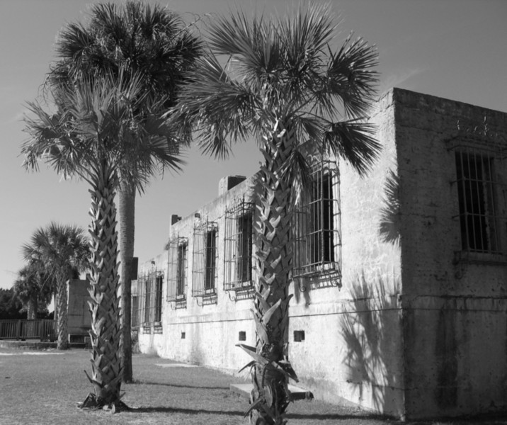
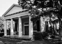
Photograph of Atalaya Castle
Photograph by The original uploader was Rono359 at English Wikipedia, Public domain. Via Wikimedia Commons.

Atalaya

Listed on the National Register of Historic Places in 1984.

From the record

“Atalaya Castle, often known simply as Atalaya, was the winter home of industrialist and philanthropist Archer M. Huntington and his wife, the sculptor Anna Hyatt Huntington, located in Huntington Beach State Park near the Atlantic coast in Murrells Inlet, Georgetown County, South Carolina.”

Wikipedia article Atalaya Castle (US), CC BY-SA 4.0.

One of 38 National Register listings published here for Georgetown County · listed in 1984 · category: Building.

Sources: the Wikipedia article · the case file at the National Archives · the National Register database, National Park Service

The listing

  • Address. Off US 17, Murrells Inlet, 29585
  • When was it listed? September 1984
  • Category. building
  • Census division. Waccamaw Neck
  • Architectural style. Mediterranean Revival architecture, Moorish Revival architecture
  • Architect. Archer Milton Huntington
  • National Register reference number. 84002045 - the number the National Park Service assigned this property when it was listed, and the key its nomination file is catalogued under at the National Archives.

Fires near this property

50 since 1992

Regional context, not property-specific evidence. The federal wildfire occurrence database lists 50 fires within 5 miles of Atalaya between 1992 and 2019, burning about 1,641 acres in total. None started naturally. 8 were recorded as arson. Distance is straight-line from the map coordinates, so a fire counted here may appear on a neighbouring settlement's page as well.

Reported cause Fires
Missing data/not specified/undetermined28
Debris and open burning12
Arson/incendiarism8
Equipment and vehicle use1
Misuse of fire by a minor1

The most recent of them, most recent first, with the day each was reported and the service that recorded it.

DateCause SizeReported by Name on the report
20 September 1995Missing data/not specified/undeterminedunder an acreSouth Carolina Forestry Commissionnot named
24 August 2016Debris and open burning1.0 acresSouth Carolina Forestry Commissionnot named
16 July 1992Missing data/not specified/undetermined10 acresSouth Carolina Forestry Commissionnot named
4 June 2001Arson/incendiarism5.0 acresSouth Carolina Forestry Commissionnot named
5 May 2001Debris and open burning2.0 acresSouth Carolina Forestry Commissionnot named
5 May 2001Arson/incendiarism1.0 acresSouth Carolina Forestry Commissionnot named
15 May 2000Debris and open burningunder an acreSouth Carolina Forestry Commissionnot named
15 May 1997Missing data/not specified/undetermined1.0 acresSouth Carolina Forestry Commissionnot named

Every fire recorded in Georgetown County

Storms near this property

37 since 1996

Regional context, not property-specific evidence. The National Weather Service names Murrells Inlet, the town this property stands in, in 37 storm reports between 1996 and 2024: 15 hail, 10 thunderstorm wind, 7 flash flood, 2 waterspout. The reports record 1 death and 5 injuries. Each account below is quoted exactly as the forecast office filed it, from the NOAA Storm Events Database, and each date opens the federal record of that event.

WhenEvent Place namedHarm What the report says
September 2004Rip CurrentMurrells Inlet1 killedStrong rip currents caused by the swells from Hurricane Jeanne resulted in a drowning. Five other people had to be rescued by lifeguards.
June 1998LightningMurrells Inlet3 hurtno account filed
August 2001LightningMurrells Inlet2 hurtEmergency manager reported that two people were struck by lightning. The extent of the injuries is unknown.
August 1996Flash FloodMurrells Inlet$100,000no account filed
May 2010HailMurrells Inlet$3,000Hail up to the size of nickels was reported.
May 2012HailMurrells Inlet$2,000Hail up to the size of quarters was reported on Hyatt Avenue. The hail stopped and started several times over a half hour period.
July 2010Thunderstorm WindMurrells Inlet$1,500A tree was down across Higway 17 near Wachesaw Road.
August 2024Flash FloodMurrells Inlet$1,000Flash flooding along Parsonage Lane near the US-17 Business intersection.
August 2024Flash FloodMurrells Inlet$1,000Flash flooding along Wachesaw Road in Murrells Inlet. Mesonet reports show that over 4 inches of rain had fallen in that area over the previous 5-6 hours.
May 2011HailMurrells Inlet$1,000Hail to the size of quarters was reported. The time was estimated based on radar data.
May 2010HailMurrells Inlet$1,000Hail to the size of pennies was reported.
July 2010Thunderstorm WindMurrells Inlet$1,000A tree was reported down on Morse Drive. The time was estimated based on radar data.
July 2010Thunderstorm WindMurrells Inlet$1,000A tree was reported down across New River Road. The time was estimated based on radar data.
November 2012HailMurrells Inlet$500Hail to the size of quarters was reported along Pendergrass Avenue.
May 2012Thunderstorm WindMurrells Inlet$500Three to four inch diameter tree limbs were blown down on Hyatt Avenue. The wind was estimated to 50 to 60 mph.
April 2011HailMurrells Inlet$500Hail to the size of quarters was reported.
August 2024Flash FloodMurrells Inlet-Flash flooding occurred along Belair Avenue in Murrells Inlet.
April 2023Thunderstorm WindMurrells Inlet-Structural damage to roof and sunroom at a home on South Marlin Circle in Murrells Inlet.
December 2023Thunderstorm WindMurrells Inlet-Tree uprooted in Murrells Inlet.
May 2021HailMurrells Inlet-Ping pong size hail was reported.
September 2016Flash FloodMurrells Inlet-There was a partial washout of the road in front of Big Dave's Tackle.
June 2009HailMurrells Inlet-Hail to the size of quarters was reported.
June 2008Thunderstorm WindMurrells Inlet-A large tree was down on Pendergrass Avenue.
July 2007Thunderstorm WindMurrells Inlet-Wind felled a light pole onto a car along US Highway 701.
April 2006HailMurrells Inlet-Nickel size hail was reported at the fire department in Pleasant Hill.
May 2006HailMurrells Inlet-Penny to nickel size hail was reported at the International Golf Club.
June 2002Thunderstorm WindMurrells Inlet-Trained spotter estimated 60 mph wind gust.
September 1999Flash FloodMurrells Inlet-Heavy rains associated with hurricane Floyd accumulated 9 to 15 inches in the eastern part of the county, causing flooding 3 feet deep in some areas...especially around Murrells Inlet. The City of Georgetown was also flooded.
August 1998Flash FloodMurrells Inlet-Heavy rains from slow moving thunderstorms measuring 3 to 5 inches caused overflowing ditches and flooding along roadways.
August 1998WaterspoutMurrells Inlet-Residents from Murrells Inlet to Litchfield Beach reported waterspouts developing from showers and thunderstorms off the coast. The waterspouts remained off the coast and caused no damage.
May 1997HailMurrells Inlet-Reported by Skywarn Spotter
May 1997HailMurrells Inlet-Reported by Fire Chief 1/2 mile north of Murrells Inlet
May 1998HailMurrells Inlet-no account filed
June 1998WaterspoutMurrells Inlet-no account filed
July 1997HailMurrells Inlet-no account filed
May 1996HailMurrells Inlet-no account filed
October 1996Thunderstorm WindMurrells Inlet-no account filed

Every storm recorded in Georgetown County

Map coverage status

No historic map-sheet match is published for this property yet. That does not mean no map exists. This record needs a coordinate-quality review before it can be joined to a sheet boundary. Browse the county's mapped places while that work is pending.

Listed places nearby

6 within 8 miles

Other National Register properties close enough to walk or drive between, ordered by distance from this one. Both positions come from the same geocoding pass that matched these properties to their map sheets.

Photograph PropertyDistance Listed
Brookgreen Gardens1.5 miles1978
Parrish's Motor Court2.3 miles2017
Sandy Island School2.6 miles2020
Holy Cross Faith Memorial School3.9 miles2024
Cedar Grove Plantation Chapel4.4 miles1991
All Saints' Episcopal Church, Waccamaw4.4 miles1991

Sources for this property

National Archives recordThe nomination case file for reference 84002045 in Record Group 79.
Wikipedia articleCommunity-written account of this property, licensed CC BY-SA.
Georgetown CountyAll 38 listed properties in this county.

Provenance

  • Listing record. National Park Service National Register of Historic Places, listed-properties dataset, current to 2026-05-22.
  • Map join. Address geocoded through the United States Census geocoder, then tested against the published boundary of every sheet in the USGS Historical Topographic Map Collection.
  • How this page is made. Listing fields come from federal records; map-sheet coverage is a labelled coordinate-to-boundary calculation, not a source-field claim.
  • Wildfire. Short, Karen C. 2022. Spatial wildfire occurrence data for the United States, 1992-2020 [FPA_FOD_20221014]. 6th Edition. Fort Collins, CO: Forest Service Research Data Archive. https://doi.org/10.2737/RDS-2013-0009.6 Collected with United States Government funding and usable without additional permissions or fees.
  • Storms. NOAA National Centers for Environmental Information, Storm Events Database https://www.ncei.noaa.gov/stormevents/ A work of the United States government, no copyright under 17 U.S.C. 105. Narratives are quoted verbatim from the National Weather Service report and are not edited or summarised.