BlockBefore
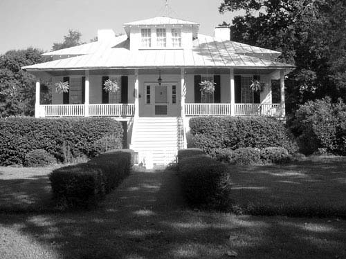
Photograph of Orange Grove
Photograph by South Carolina Department of Archives and History, CC0 1.0. Via Wikimedia Commons.

Orange Grove

Listed on the National Register of Historic Places in 1993.

From the record

“Orange Grove, also known as the Gaillard-Colclough House, is an historic 39.9-acre (161,000 m2) plantation and its plantation house at Gaillard's Crossroads,, north of Dalzell, South Carolina. It was added to the National Register of Historic Places on August 19, 1993.”

Wikipedia article Orange Grove (Dalzell, South Carolina), CC BY-SA 4.0.

One of 28 National Register listings published here for Sumter County · listed in 1993 · category: Building.

Sources: the Wikipedia article · the case file at the National Archives · the National Register database, National Park Service · the Wikipedia article

The listing

  • Address. Jct. of SC 43 (Black River Rd.) and SC 441, Dalzell, 29128
  • When was it listed? August 1993
  • Category. building
  • Census division. Shaw AFB-Horatio
  • Architectural style. Greek Revival architecture
  • National Register reference number. 93000845 - the number the National Park Service assigned this property when it was listed, and the key its nomination file is catalogued under at the National Archives.

Fires near this property

375 since 1992

Regional context, not property-specific evidence. The federal wildfire occurrence database lists 375 fires within 5 miles of Orange Grove between 1992 and 2020, burning about 2,017 acres in total. 6 started naturally. 26 were recorded as arson. Distance is straight-line from the map coordinates, so a fire counted here may appear on a neighbouring settlement's page as well.

Reported cause Fires
Debris and open burning190
Missing data/not specified/undetermined109
Arson/incendiarism26
Misuse of fire by a minor19
Equipment and vehicle use15
Natural6
Power generation/transmission/distribution5
Smoking4
Other causes1

The most recent of them, most recent first, with the day each was reported and the service that recorded it.

DateCause SizeReported by Name on the report
8 September 2018Power generation/transmission/distributionunder an acreSouth Carolina Forestry Commissionnot named
5 September 2010Debris and open burningunder an acreSouth Carolina Forestry Commissionnot named
5 September 2007Debris and open burning2.0 acresSouth Carolina Forestry Commissionnot named
4 September 2007Debris and open burning2.5 acresSouth Carolina Forestry Commissionnot named
4 September 1999Debris and open burning40 acresSouth Carolina Forestry Commissionnot named
30 September 2009Debris and open burning6.0 acresSouth Carolina Forestry Commissionnot named
29 September 2019Natural2.0 acresSouth Carolina Forestry Commissionnot named
28 September 1994Missing data/not specified/undetermined16 acresSouth Carolina Forestry Commissionnot named

Every fire recorded in Sumter County

Mines and quarries near this property

1 within 5 miles

Regional context, not property-specific evidence. The federal mineral resources record lists 1 working within 5 miles of Orange Grove: 1 producer. All of them still produce. What was taken out: Sand and Gravel, Construction. Distance is straight-line from the map coordinates, so a quarry counted here may appear on a neighbouring settlement's page as well.

Where SiteCommodity StatusRecorded
Smg PitSand and Gravel, ConstructionProducer

Every working recorded in Sumter County

Storms near this property

26 since 1999

Regional context, not property-specific evidence. The National Weather Service names Dalzell, the town this property stands in, in 26 storm reports between 1999 and 2025: 19 thunderstorm wind, 4 hail, 2 flash flood, 1 heavy rain. No death or injury is recorded in these reports. Each account below is quoted exactly as the forecast office filed it, from the NOAA Storm Events Database, and each date opens the federal record of that event.

WhenEvent Place namedHarm What the report says
April 2011HailDalzell$40,000Golfball size hail reported in Dalzell - relayed by COCORAHS observer.
September 2011Thunderstorm WindDalzell$12,000Trees down between Sumter and Rembert at Catchall Rd. and SC 261 and also at Furman Field Rd. and US 521.
April 2013Thunderstorm WindDalzell$10,000Public and Emergency Manager reported numerous trees down around the Dalzell area. The Public reported 47 trees either downed or leaning over in the Kel Sam Farms Subdivision in Dalzell.
June 2011Thunderstorm WindDalzell$10,000Sheriff and public reported trees down across western Sumter county from Cherryvale area to the Privateer area.
March 2023Flash FloodDalzell$5,000Sumter Co EM provided reports and photos of flooded and impassable roads along Thomas Sumter Hwy (US Hwy 521) from Frierson Rd to Kel-Sam Rd near Dalzell. Times estimated.
May 2012Thunderstorm WindDalzell$4,000Highway Patrol reported trees down near the intersection of Seymour Road and Sargent Road.
June 2011Thunderstorm WindDalzell$4,000Highway Patrol reported trees down at Furman Field road and Hwy 441.
July 2009Thunderstorm WindDalzell$4,000Black River Electric Coop reported trees and powerlines down on Catchall road near Dalzell.
July 2009Thunderstorm WindDalzell$1,000Black River Electric Coop reported trees and powerlines down on Shakemia road just off hwy 441 north of Shaw AFB.
April 2023HailDalzell$100Public report of pea size hail in Dalzell, that lasted about 10 minutes.
June 2025Thunderstorm WindDalzell-Sumter sheriff office reported trees down in Dalzell area. Time estimated by radar.
June 2025Flash FloodDalzell-Sumter Fire reported water over the roadway on Camden Highway at Valencia Drive.
March 2023Heavy RainDalzell-A CoCoRaHS observer reported a 24 hour rainfall amount of 5.95 inches about 2 miles SW of Dalzell. Most of this rain fell late in the night of March 26th through the early morning hours of March 27th.
August 2023Thunderstorm WindDalzell-Dispatchers reported a tree down near Fireson Road and Charles Jackson Street.
June 2022Thunderstorm WindDalzell-Tree down on Peach Orchard Rd and Seymour Dr, north of Shaw AFB. Time estimated.
August 2019Thunderstorm WindDalzell-SCHP reported tree in roadway on Peach Orchard Rd at Commonwealth Ct. Time estimated.
March 2018Thunderstorm WindDalzell-Social media report of a tree down on Sargent Rd at Estella Rd near Dalzell.
June 2018Thunderstorm WindDalzell-SCHP reported trees in roadway at Dodgen Hill Rd at Peach Orchard Rd. Time estimated.
March 2017Thunderstorm WindDalzell-SC Highway Patrol reported trees down at Hwy 441 and Shakemia Rd.
April 2017HailDalzell-Half dollar size hail photographed near Dalzell.
July 2017Thunderstorm WindDalzell-Trees down along Black River Rd. A downed tree was blocking Crestview Rd near Black River Rd. A power line was down near Dorsey Dr.
June 2011Thunderstorm WindDalzell-Public reported large limbs down.
June 2004Thunderstorm WindDalzell-Post Office reported large branches down around the area.
July 2003Thunderstorm WindDalzell-Shaw AFB employees reported trees down in Dalzell.
June 2002Thunderstorm WindDalzell-Utility company reported a few trees and powerlines down from Dalzell to the Municipal Airport.
April 1999HailDalzell-Sheriff reported nickel size hail.

Every storm recorded in Sumter County

Map coverage status

No historic map-sheet match is published for this property yet. That does not mean no map exists. This record needs a coordinate-quality review before it can be joined to a sheet boundary. Browse the county's mapped places while that work is pending.

Listed places nearby

4 within 8 miles

Other National Register properties close enough to walk or drive between, ordered by distance from this one. Both positions come from the same geocoding pass that matched these properties to their map sheets.

Photograph PropertyDistance Listed
Ellerbe's Mill5.6 miles1974
Stateburg Historic District6.9 miles1971
Lenoir Store7.7 miles1997
Magnolia Hall7.7 miles1999

Sources for this property

National Archives recordThe nomination case file for reference 93000845 in Record Group 79.
Wikipedia articleCommunity-written account of this property, licensed CC BY-SA.
Sumter CountyAll 28 listed properties in this county.

Provenance

  • Listing record. National Park Service National Register of Historic Places, listed-properties dataset, current to 2026-05-22.
  • Map join. Address geocoded through the United States Census geocoder, then tested against the published boundary of every sheet in the USGS Historical Topographic Map Collection.
  • How this page is made. Listing fields come from federal records; map-sheet coverage is a labelled coordinate-to-boundary calculation, not a source-field claim.
  • Wildfire. Short, Karen C. 2022. Spatial wildfire occurrence data for the United States, 1992-2020 [FPA_FOD_20221014]. 6th Edition. Fort Collins, CO: Forest Service Research Data Archive. https://doi.org/10.2737/RDS-2013-0009.6 Collected with United States Government funding and usable without additional permissions or fees.
  • Mines and quarries. USGS Mineral Resources Data System (MRDS) https://mrdata.usgs.gov/mrds/ A work of the United States government, no copyright under 17 U.S.C. 105.
  • Storms. NOAA National Centers for Environmental Information, Storm Events Database https://www.ncei.noaa.gov/stormevents/ A work of the United States government, no copyright under 17 U.S.C. 105. Narratives are quoted verbatim from the National Weather Service report and are not edited or summarised.