BlockBefore
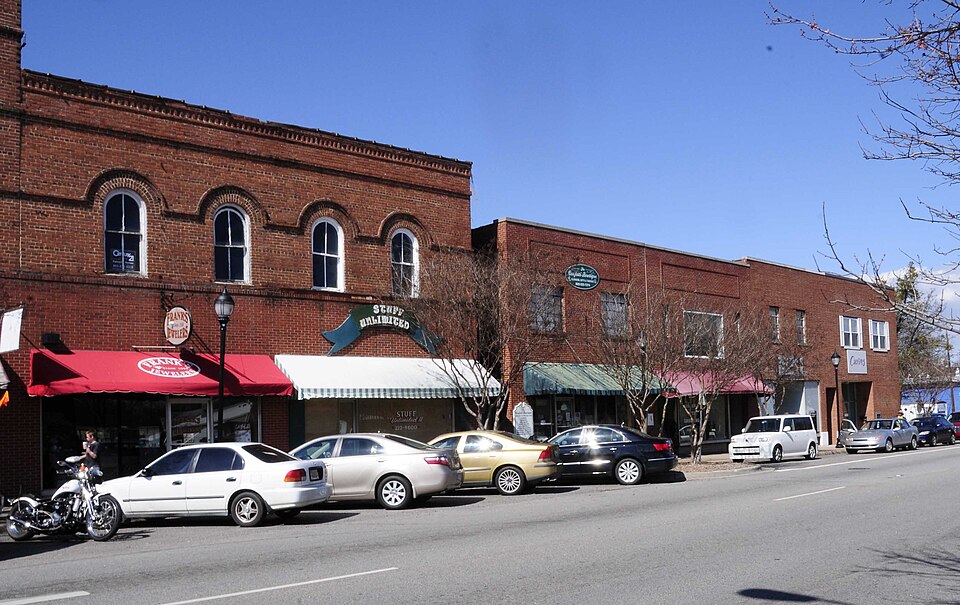
Photograph of Clover Downtown Historic District
Photograph by Bill Fitzpatrick, CC BY-SA 3.0. Via Wikimedia Commons.

Clover Downtown Historic District

Listed on the National Register of Historic Places in 1999.

From the record

“Clover Downtown Historic District is a national historic district located at Clover, York County, South Carolina. It encompasses 14 contributing buildings in the central business district of Clover.”

Wikipedia article Clover Downtown Historic District, CC BY-SA 4.0.

One of 62 National Register listings published here for York County · listed in 1999 · category: District.

Sources: the Wikipedia article · the case file at the National Archives · the National Register database, National Park Service
The listing

  • What is counted as historic. The nomination lists 14 buildingss as contributing to the listing.
  • Address. Jct. of Main and Kings Mountain Sts., Clover, 29710
  • When was it listed? July 1999
  • Category. district
  • Census division. Clover
  • National Register reference number. 99000816 - the number the National Park Service assigned this property when it was listed, and the key its nomination file is catalogued under at the National Archives.

Fires near this property

113 since 1992

Regional context, not property-specific evidence. The federal wildfire occurrence database lists 113 fires within 5 miles of Clover Downtown Historic District between 1992 and 2019, burning about 299 acres in total. 2 started naturally. 5 were recorded as arson. Distance is straight-line from the map coordinates, so a fire counted here may appear on a neighbouring settlement's page as well.

Reported cause Fires
Missing data/not specified/undetermined45
Debris and open burning35
Misuse of fire by a minor15
Equipment and vehicle use5
Arson/incendiarism5
Recreation and ceremony3
Other causes2
Natural2
Smoking1

The most recent of them, most recent first, with the day each was reported and the service that recorded it.

DateCause SizeReported by Name on the report
8 September 1997Debris and open burningunder an acreSouth Carolina Forestry Commissionnot named
25 September 2010Debris and open burning2.0 acresSouth Carolina Forestry Commissionnot named
25 September 2010Equipment and vehicle useunder an acreNorth Carolina Forest ServiceCOPPERHEAD
2 September 1993Missing data/not specified/undetermined10 acresSouth Carolina Forestry Commissionnot named
11 September 1993Missing data/not specified/undetermined3.0 acresSouth Carolina Forestry Commissionnot named
6 August 2002Missing data/not specified/undetermined3.0 acresSouth Carolina Forestry Commissionnot named
30 August 2007Debris and open burningunder an acreSouth Carolina Forestry Commissionnot named
25 August 1992Missing data/not specified/undeterminedunder an acreSouth Carolina Forestry Commissionnot named

Every fire recorded in York County

Mines and quarries near this property

10 of 15 shown

Regional context, not property-specific evidence. The federal mineral resources record lists 15 workings within 5 miles of Clover Downtown Historic District: 5 unknowns, 5 past producers, 3 occurrences, 2 prospects. None of them still produces. What was taken out: Kyanite, Gold, Barium-Barite, Manganese, Iron. Distance is straight-line from the map coordinates, so a quarry counted here may appear on a neighbouring settlement's page as well.

Where SiteCommodity StatusRecorded
Allison ProspectGold, Sulfur, CopperProspect
Allison ProspectGold, CopperUnknown1908
Clover QuarryGranite, Stone, Crushed/BrokenPast Producer1976
Clover QuarryStone, Crushed/BrokenPast Producer
Ford Biotite Granite QuarryStoneUnknown1900
Henry Knob MineKyanite, Iron-PyritePast Producer1846, 1948, 1969
Mary MineCopper, Gold, Barium-BariteUnknown1850, 1856
Ryan-Purcley Sillimanite PropertyKyanite, QuartzUnknownStratabound
James Adams Manganese OccurrenceManganese, IronOccurrence1944
Manganese Outcrop OccurrenceManganese, IronOccurrence1944

Every working recorded in York County

Storms near this property

45 since 1994

Regional context, not property-specific evidence. The National Weather Service names Clover, the town this property stands in, in 45 storm reports between 1994 and 2025: 26 thunderstorm wind, 12 hail, 3 tornado, 2 lightning. The reports record 1 death and 1 injury. Each account below is quoted exactly as the forecast office filed it, from the NOAA Storm Events Database, and each date opens the federal record of that event.

WhenEvent Place namedHarm What the report says
July 2002LightningClover1 killedLightning struck a tree, which fell on and killed a bicyclist.
March 1994Tornado (F1)Clover1 hurt, $500,000Tornado developed near North Carolina/South Carolina border and moved into North Carolina within a short distance from where Highway SC49 crosses North Carolina line at 1844 EST. One mobile home in the Lake Wylie Mobile Home Park along Stateline Road was completely destroyed with debris scattered in a cyclonic pattern. Several other mobile homes were heavily damaged, an outbuilding completely disappeared, many trees were downed and one person injured. The tornado apparently developed from the same storm that earlier had caused spotty damage across the County.
March 1994Thunderstorm WindClover$500,000Downburst winds during a thunderstorm destroyed a mobile home, damaged a nearby residence and destroyed outbuilding and felled trees on C.E. Stewart Road about 7 miles WSW of Clover.
March 1994Thunderstorm WindClover$50,000Trees down, 2 barns destroyed, power lines down.
May 1995Thunderstorm WindClover$10,000Tornado moved from SC46-43 in southwest York northeastward to U.S. 321 in northern York. The tornado was mostly a "tree-topper" with four separate touchdowns. The first touchdown blew trees on a home, flattened a garage onto a car with total damage of 20K, The second touchdown destroyed a large lumber storage building at ACE Hardware and partially deroofed another causing a loss of $15,000. The third touchdown took down a grove of trees and sheared off the top of others. The last touchdown took half the roof off a building with a loss of $10,000. Thunderstorm blew down trees and power lines in Clover.
July 2005Thunderstorm WindClover$5,000Numerous trees down in the Clover and Lake Wylie areas. In the Rock Hill area, a large tree fell on a vehicle, trapping the occupant inside.
March 1994Thunderstorm WindClover$5,000Trees down, considerable minor damage to roofs, chimneys, etc. Heaviest damage immediately northeast of Clover.
November 2002Thunderstorm WindClover$3,000Numerous trees and power lines were blown down.
November 2003Thunderstorm WindClover$2,000A storage trailer was blown over.
August 2003Thunderstorm WindClover$1,000A couple of trees and some power lines were blown down.
April 1998Tornado (F0)Clover$500no account filed
August 2025Thunderstorm WindClover-Emergency manager reported multiple trees blown down on Lawrence Rd.
June 2022Thunderstorm WindClover-Public reported multiple large tree limbs snapped and a large tree uprooted.
August 2019Thunderstorm WindClover-County comms reported several trees blown down in the Clover area.
March 2018HailClover-Public reported nickel sized hail in the Clover area.
November 2016Thunderstorm WindClover-County comms reported multiple trees blown down in and around Clover.
May 2014HailClover-County comms reported 3/4 inch hail near Clover.
June 2014Thunderstorm WindClover-PD reported a tree blown down at Faulkner Rd and Neely Rd. County comms reported a tree down on Westland Dr in the same area.
May 2011Thunderstorm WindClover-A tree was blown down on the northeast side of Clover.
April 2011HailClover-Two inch diameter hail fell near the intersection of highway 55 and Kingsbury Rd.
April 2011HailClover-Hail up to the size of a softball was measured on Cedar Hill Rd.
April 2011HailClover-A second severe thunderstorm produced another round of very large hail near the Kingsbury Rd and highway 55 intersection.
April 2011HailClover-A third hail storm affected the county with a swath of hail up to golf ball size affecting areas from Clover to York.
May 2011Thunderstorm WindClover-Several trees were blown down in and around Clover with some trees blocking roads.
June 2007Thunderstorm WindClover-Several trees and power lines blown down in the Clover area.
May 2006Thunderstorm WindClover-Trees and power lines blown down in Clover.
July 2006Thunderstorm WindClover-Trees and power lines down on Crossland Rd.
July 2006Thunderstorm WindClover-Numerous large tree limbs blown down, mainly along Ridge Rd.
November 2006Thunderstorm WindClover-Large limbs down on St Paul Church Rd.
May 2005LightningClover-Lightning struck a tree and a barn, igniting a fire.
July 2005Flash FloodClover-Water flowed over several roads in the Clover area, including highway 321 and Fox Rd and Gabbie Ford Rd in York.
May 2004Thunderstorm WindClover-Some large limbs and brush were blown into a road. A vehicle was also forced off the road by the high winds.
June 2001Thunderstorm WindClover-Several six-inch diameter pine trees blown down. A SKYWARN spotter measured a wind gust to 62 mph.
October 2001Thunderstorm WindClover-Trees were blown over onto Highway 55.
August 2000Thunderstorm WindClover-Trees and power lines were downed and a few fires were sparked.
June 2007HailClover-no account filed
June 1999HailClover-no account filed
January 1998HailClover-no account filed
April 1998HailClover-no account filed
February 1997Tornado (F0)Clover-no account filed
April 1997HailClover-no account filed
June 1996Thunderstorm WindClover-no account filed
June 1996HailClover-no account filed
April 1996Heavy RainClover-no account filed
July 1996Thunderstorm WindClover-no account filed

Every storm recorded in York County

Map coverage status

No historic map-sheet match is published for this property yet. That does not mean no map exists. This record needs a coordinate-quality review before it can be joined to a sheet boundary. Browse the county's mapped places while that work is pending.

Listed places nearby

3 within 8 miles

Other National Register properties close enough to walk or drive between, ordered by distance from this one. Both positions come from the same geocoding pass that matched these properties to their map sheets.

Photograph PropertyDistance Listed
Bethel Presbyterian Church4.2 miles1980
York Historic District7.8 miles1979
Witherspoon-Hunter House8.0 miles1978

Sources for this property

National Archives recordThe nomination case file for reference 99000816 in Record Group 79.
Wikipedia articleCommunity-written account of this property, licensed CC BY-SA.
York CountyAll 62 listed properties in this county.

Provenance

  • Listing record. National Park Service National Register of Historic Places, listed-properties dataset, current to 2026-05-22.
  • Map join. Address geocoded through the United States Census geocoder, then tested against the published boundary of every sheet in the USGS Historical Topographic Map Collection.
  • How this page is made. Listing fields come from federal records; map-sheet coverage is a labelled coordinate-to-boundary calculation, not a source-field claim.
  • Wildfire. Short, Karen C. 2022. Spatial wildfire occurrence data for the United States, 1992-2020 [FPA_FOD_20221014]. 6th Edition. Fort Collins, CO: Forest Service Research Data Archive. https://doi.org/10.2737/RDS-2013-0009.6 Collected with United States Government funding and usable without additional permissions or fees.
  • Mines and quarries. USGS Mineral Resources Data System (MRDS) https://mrdata.usgs.gov/mrds/ A work of the United States government, no copyright under 17 U.S.C. 105.
  • Storms. NOAA National Centers for Environmental Information, Storm Events Database https://www.ncei.noaa.gov/stormevents/ A work of the United States government, no copyright under 17 U.S.C. 105. Narratives are quoted verbatim from the National Weather Service report and are not edited or summarised.