 Block
From the record
18 National Register listings published here.
Sources: the National Register database, National Park Service
45 topographic sheets cover 16 settlements here, and 18 properties are on the National Register of Historic Places.
18 National Register listings published here.
Sources: the National Register database, National Park Service
Every property in this county listed on the National Register of Historic Places, with the year it was listed and the federal nomination document.
| Photograph | Property | Type | Listed | Reference |
|---|---|---|---|---|
| Anderson Barn | building | 2003 | 03000763 | |
 | Faye Bowden House-Agnus Saunders | building | 1998 | 98001401 |
| Campbell Park Historic District of Huron | district | 1974 | 74001888 | |
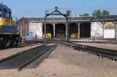 | Chicago and North Western Roundhouse | building | 1998 | 98001411 |
| Dairy Building | building | 1990 | 90001642 | |
 | Hattie O. and Henry Drake Octagon House | building | 1992 | 91002045 |
 | Grace Episcopal Church | building | 1989 | 89000828 |
| Habicht & Habicht Department Store | building | 2020 | 100005318 | |
| Jefferson School | building | 2019 | 100004620 | |
 | Margaret and Vernon Maxon House | building | 1999 | 98001409 |
| McMonies Barn | building | 2004 | 04000762 | |
| Milford Hutterite Colony | district | 1982 | 82003909 | |
| Old Riverside Hutterite Colony | district | 1982 | 82003910 | |
| Albert S. Piper Homestead Claim Shanty | building | 1998 | 98001126 | |
 | Pyle House | building | 1974 | 74002288 |
| South Dakota Dept. of Transportation Bridge No. 03-020-008 | structure | 1993 | 93001260 | |
| South Dakota Dept. of Transportation Bridge No. 03-327-230 | structure | 1993 | 93001261 | |
| South Dakota Dept. of Transportation Bridge No. 03-338-100 | structure | 1993 | 93001269 |
Every wildfire the federal occurrence database records inside this county: 152 of them, burning about 6,531 acres. 8 started naturally and 7 were recorded as arson. Each settlement page carries the fires within five miles of it.
| Reported cause | Fires |
|---|---|
| Missing data/not specified/undetermined | 55 |
| Debris and open burning | 49 |
| Equipment and vehicle use | 23 |
| Natural | 8 |
| Arson/incendiarism | 7 |
| Railroad operations and maintenance | 4 |
| Recreation and ceremony | 2 |
| Fireworks | 1 |
| Smoking | 1 |
| Misuse of fire by a minor | 1 |
| Other causes | 1 |
The five largest, by the area the report gives. One of them was set deliberately.
| Date | Cause | Size | Reported by | Name on the report |
|---|---|---|---|---|
| 22 April 2009 | Debris and open burning | 1,250 acres | South Dakota Wildland Fire Suppression | not named |
| 17 July 2002 | Equipment and vehicle use | 1,000 acres | Huron Wetland Management District | ROSEHILL |
| 21 March 2003 | Debris and open burning | 620 acres | Huron Wetland Management District | CAIN CREEK |
| 26 March 1999 | Railroad operations and maintenance | 400 acres | Bristol Volunteer Fire Department | BNSF |
| 26 March 2004 | Debris and open burning | 300 acres | South Dakota Wildland Fire Suppression | LEGRAND |
| 5 December 1999 | Arson/incendiarism | 300 acres | Huron Volunteer Fire Dept. | ROGER WALLMAN |
| 20 November 2017 | Debris and open burning | 200 acres | South Dakota Wildland Fire Suppression | LARSEN BRUSH |
| 12 February 2000 | Debris and open burning | 200 acres | Hitchcock Volunteer Fire Department | LYLE MARSHALL #1 |
Every settlement page carries the fires within five miles of it - see the settlement index below.
The NOAA Storm Events Database holds 689 reports for this county, causing no deaths, 3 injuries and about $24,653,530 in recorded property damage. Each settlement page carries the reports that name it.
| Kind of event | Reports |
|---|---|
| Hail | 286 |
| Thunderstorm Wind | 282 |
| Flood | 59 |
| Tornado | 38 |
| Flash Flood | 12 |
| Heavy Rain | 4 |
| Lightning | 4 |
| Funnel Cloud | 4 |
The most serious of them, by death, then injury, then recorded damage. The accounts are quoted exactly as the forecast office filed them.
| When | Event | Place named | Harm | What the report says |
|---|---|---|---|---|
| August 2006 | Tornado (F3) | Wessington | 2 hurt, $15,000,000 | A tornado, entering Beadle County from Hand County to the west, destroyed 8 houses, damaged at least 7 other houses, and destroyed or damaged numerous farm buildings. One of the destroyed houses and several destroyed small buildings were on a farmstead 2 miles south of Wessington, and five large high voltage transmission towers were blown down about 3 miles southeast of Wessington. A woman was cut on the neck at one farm southwest of Wolsey where the house and all other buildings were destroyed; the injury was not life threatening. The tornado tossed a car and 2 pickups up to 50 feet at the same farm. Another non life threatening injury occurred southeast of Wolsey, again on a farm where the house and all buildings were destroyed. Several vehicles were destroyed or damaged. The tornado killed 10 head of cattle at one farmstead just south of Wolsey. The tornado snapped off numerous power poles, caused widespread tree damage, and severely damaged a bridge where it crossed U.S. Highway 14. The tornado also caused crop damage, but the amount of crop damage was not known. The tornado dissipated one and a half miles southwest of Huron. |
| September 1967 | Tornado (F1) | not stated | 1 hurt, $2,500 | no account filed |
| April 2011 | Flood | Bonilla | $2,000,000 | Major flooding of the James River, as well as flooding of small streams and lakes in the county, continued through April. Much farmland remained flooded, both near to and away from the James River. The James River was 7.3 feet above flood stage at Huron on April 1st, and fell very slowly during the month. Over 50 miles of roads remained closed by the flooding at the start of the month, including South Dakota Highway 28 in the eastern part of the county. Water was running over other roads, from flooded streams, creeks, and fields as well as from the James River. Many roads were heavily damaged. The damage to township and county roads alone was estimated near the end of April at 1.7 million dollars. Some homes and businesses were also flooded, with the flooding of these places slowly alleviating through the month. High water and groundwater levels from record precipitation in the year 2010, a main reason the flooding onset was so fast in March, was also a main reason that the flooding subsided so slowly during April. |
| August 2006 | Tornado (F2) | Huron | $2,000,000 | A tornado severely damaged 3 houses and destroyed or damaged a barn and several smaller buildings on farmsteads. The tornado knocked down power poles, with a transformer on one of the poles starting a brief fire. A tree shelter belt and crops were damaged. The amount of crop damage was not known. |
| June 2003 | Tornado (F3) | Cavour | $1,500,000 | A tornado destroyed farm buildings and numerous trees, resulting in F3 damage southwest of Cavour. Homes and businesses within the town of Cavour were severely damaged (F2). Winds of 120 mph were measured by an anemometer on top of a grain elevator in Cavour. |
| August 2002 | Thunderstorm Wind | Huron | $1,000,000 | Thunderstorm winds destroyed a car wash, blew the roof off a recreation center and bowling alley with resulting damage to the inside, and damaged an apartment building and former restaurant. The winds also caused tree damage, including large trees blown down, and blew down power poles and lines. |
| August 1998 | Thunderstorm Wind | Huron | $1,000,000 | no account filed |
| May 2007 | Flood | Broadland | $500,000 | Heavy rainfall caused flooding of low areas including fields, homes, businesses, schools, roads, streams, and bridges. The flooding was a longer term event than flash flooding, which had also resulted. Long term major flooding of the James River also resulted, with the river peaking at 6.7 feet above flood stage at Huron on May 7th. Numerous parks and other recreation areas were affected, especially in the Huron area. Some roads and bridges were washed out by the high water. The flooding delayed planting of crops in some areas. |
| June 2013 | Thunderstorm Wind | Huron | $200,000 | Thunderstorm winds peeled off an apartment roof, damaging contents inside with water and wind, and displacing the residents of ten units. The winds also caused extensive tree and power line damage, some roof damage, and blew over two nearby semi trucks. Signs were also blown over. |
| August 2004 | Thunderstorm Wind | Huron | $200,000 | Thunderstorm winds blew down numerous power lines, several poles, and caused widespread tree damage. Several roads were blocked by large limbs and other debris. The winds also blew the roof off a mobile home, destroyed a small storage building, and damaged other small structures. Numerous vehicles and some homes were damaged by tree debris. |
| March 2019 | Flood | Virgil | $110,000 | Flooding resulted in damage to public infrastructure including county and township roads and culverts. |
| August 2011 | Thunderstorm Wind | Wessington | $100,000 | Thunderstorm winds blew the roof off a storage building at a business, blew down power lines, destroyed a machine shed on a farm, damaged farm equipment inside the shed, and caused widespread tree damage. The tree damage affected about 15 percent of the trees in the town of Wessington. |
| June 2002 | Thunderstorm Wind | Huron | $100,000 | Thunderstorm winds caused tree damage, including a few trees blown down. The roof of an apartment building was also damaged. |
| July 2002 | Thunderstorm Wind | Huron | $100,000 | Thunderstorm winds caused widespread tree damage. The winds also blew down power lines and poles, resulting in a power outage. Minor damage to homes was also reported. |
| August 2002 | Thunderstorm Wind | (Hon)Huron Arpt | $100,000 | Thunderstorm winds in a wet microburst blew around and damaged at least three airplanes. The winds also destroyed several farm buildings, with debris blown a half mile. One farm home was damaged with windows broken and minor roof damage. Trees and power lines were down near the airport. |
| August 2000 | Thunderstorm Wind | Bonilla | $100,000 | Thunderstorm winds destroyed a dairy barn and a double garage, broke windows, and caused additional damage to a house, farm equipment, and trees. |
| July 2015 | Tornado (EF1) | Huron | $50,000 | A tornado damaged homes, mainly roofs and siding. The tornado also damaged a garage, destroyed a partially anchored storage shed, blew down power poles and lines, tossed a 5th wheel camper 75 yards, and damaged crops. |
| June 1994 | Hail | near Virgil | $50,000 | The hail damaged crops and windows. |
| October 1996 | Thunderstorm Wind | Iroquois | $50,000 | no account filed |
| June 2017 | Thunderstorm Wind | (Hon)Huron Arpt | $35,000 | Irrigation Center pivot point overturned. |
| August 2020 | Thunderstorm Wind | (Hon)Huron Arpt | $30,000 | A portion of a garage roof was torn off. A car and boat were rolled over near the house. Property damage costs are rough estimates. |
| August 2004 | Thunderstorm Wind | Huron | $30,000 | Boat lifts were blown over and several boats were blown around and damaged at Lake Byron. |
| July 1972 | Tornado (F2) | not stated | $25,000 | no account filed |
| April 1957 | Tornado (F1) | not stated | $25,000 | no account filed |
| May 1953 | Tornado (F1) | not stated | $25,000 | no account filed |
| June 2012 | Hail | Wolsey | $20,000 | Large hail dented vehicles, broke windshields, and damaged roofs. There was also an unknown amount of crop damage. |
| June 2009 | Thunderstorm Wind | Wolsey | $20,000 | Thunderstorm winds caused tree damage, including numerous trees and large limbs blown down. Falling trees and tree debris damaged power lines and caused a power outage. A car was also damaged by a falling tree. |
| August 2004 | Thunderstorm Wind | Cavour | $20,000 | Thunderstorm winds caused tree damage, including 8 inch diameter limbs broken off. Power lines were knocked down by tree debris. |
| July 2000 | Thunderstorm Wind | Cavour | $20,000 | Thunderstorm winds damaged farm buildings. |
| August 2020 | Thunderstorm Wind | (Hon)Huron Arpt | $15,000 | A camper was flipped by strong thunderstorm winds. Property damage cost is a rough estimate. |
| August 2019 | Flood | Huron | $15,000 | Water up to a foot in depth ponded across sections of South Dakota Highway 37 south of Huron. |
| July 2019 | Thunderstorm Wind | Huron | $15,000 | Several limbs down throughout Huron, along with power lines. Several uprooted trees. Numerous tents and awnings at a soccer tournament were destroyed. |
| June 2010 | Thunderstorm Wind | Huron | $15,000 | Thunderstorm winds destroyed a pole barn, and peeled back the roof of a timber supply center building. |
| August 2019 | Flood | Hitchcock | $10,000 | A continuation of flooding from July, the James River at Huron (gage site HURS2) crested 4.40 feet above flood stage on August 5. Many rural roads near the river were inundated, with continued flooding of significant amounts of agricultural land. Minor flooding continued at the end of the month. |
| August 2019 | Flood | Huron | $10,000 | Excessive rainfall caused erosion of a culvert under Truck Route 37 to the west of Huron. |
| September 2019 | Flood | Hitchcock | $10,000 | A continuation of minor flooding from August, the James River at Huron (gage site HURS2) responded rapidly mid-month to 2 to 3 inches of rainfall from September 10-12 near and upstream of Beadle County to crest 3.95 feet above flood stage on September 17. Many rural roads near the river remained inundated, with continued flooding of significant amounts of agricultural land. Minor flooding continued at the end of the month. |
| July 2003 | Thunderstorm Wind | Yale | $10,000 | Thunderstorm winds destroyed a storage shed, flipped over a fifth wheel camper, and caused tree damage, including several trees down. |
| August 2002 | Thunderstorm Wind | Huron | $10,000 | Thunderstorm winds damaged trees and power lines. |
| July 1998 | Lightning | Huron | $10,000 | no account filed |
| June 1995 | Thunderstorm Wind | Huron | $9,000 | Thunderstorm winds uprooted a three-foot diameter tree, which caused extensive damage to a nearby car. |
| August 2020 | Thunderstorm Wind | Huron | $7,500 | A power pole was snapped off by thunderstorm winds. Property damage cost is a rough estimate. |
| June 2021 | Thunderstorm Wind | Huron | $5,000 | Strong thunderstorm outflow winds took down numerous branches and several tree limbs up to 5 to 6 inches in diameter across most of the city of Huron. Crop damage is an estimate from insured losses. Information provided by the United States Department of Agriculture. Property damage costs are a rough estimate. |
| October 2019 | Flood | Hitchcock | $5,000 | A continuation of minor flooding from September, the James River at Huron (gage site HURS2) started the month at 1.23 feet above flood stage on October 1. Significant amounts of agricultural land remained flooded. Minor flooding persisted at the end of the month. Property damage costs are rough estimates. |
| August 2019 | Flood | Huron | $5,000 | Heavy rain resulted in street flooding to a depth of approximately 6 inches. |
| June 2013 | Thunderstorm Wind | Huron | $5,000 | Thunderstorm winds blew down seven power poles onto a road, and caused tree damage. |
| May 2013 | Thunderstorm Wind | Hitchcock | $5,000 | Thunderstorm winds blew a large metal bin into a mobile home. |
| May 2011 | Thunderstorm Wind | Bonilla | $5,000 | Thunderstorm winds overturned a camper. |
| May 2010 | Thunderstorm Wind | Huron | $5,000 | Thunderstorm winds blew down a 60 foot tall pine tree, and damaged the roof of a business. |
| May 2007 | Thunderstorm Wind | Iroquois | $5,000 | Thunderstorm winds damaged a barn and unrolled straw bales. |
| August 2004 | Lightning | Hitchcock | $5,000 | Lightning struck two large trees. Debris from the trees knocked down power lines, causing a power outage. |
| May 2003 | Lightning | Huron | $5,000 | Lightning struck an empty barn, causing a fire which destroyed the barn. |
| May 2003 | Lightning | Huron | $5,000 | Lightning struck a house, causing a small roof fire. |
| July 1997 | Heavy Rain | Huron | $5,000 | Heavy rainfall of 6 inches over a small area temporarily flooded lowlands, ditches, and at least one road. |
| July 1997 | Thunderstorm Wind | Broadland | $5,000 | Thunderstorm winds damaged a grain bin. |
| June 1994 | Thunderstorm Wind | Huron | $5,000 | A barn was destroyed and a hog feeder was damaged. |
| July 1994 | Thunderstorm Wind | Huron | $5,000 | Thunderstorm Winds blew the roof off of a house and destroyed a riding lawn mower at Lake Byron. |
| August 1999 | Thunderstorm Wind | Yale | $5,000 | no account filed |
| May 1998 | Hail | Huron | $5,000 | no account filed |
| August 2019 | Hail | Wessington | $3,000 | A car was dented by falling and blowing hail. |
| August 1992 | Tornado (F1) | not stated | $2,500 | no account filed |
The Survey's mineral resources record lists 6 workings inside this county. 1 still produces and 5 are closed or unrecorded. Each settlement page carries the workings within five miles of it.
| Commodity | Workings |
|---|---|
| Sand and Gravel, Construction | 6 |
The least common of them first, because a county's hundredth gravel pit says nothing its first ten did not.
| Where | Site | Commodity | Status | Recorded |
|---|---|---|---|---|
| Beadle County Highway Pit | Sand and Gravel, Construction | Past Producer | ||
| Gravel Pit | Sand and Gravel, Construction | Past Producer | ||
| Gravel Pit | Sand and Gravel, Construction | Past Producer | ||
| Gravel Pit | Sand and Gravel, Construction | Past Producer | ||
| Gravel Pit | Sand and Gravel, Construction | Past Producer | ||
| Gravel Pit | Sand and Gravel, Construction | Producer |
Named settlements recorded in the Geographic Names Information System, each with the topographic sheets covering it. Villages, hamlets and abandoned places alike. Each is shown with the nearest named watercourse or landform and the survey quadrangle it falls on.
Lake Byron township · 57350 · On Foster Creek · Lake Byron quadrangle
11 sheets, 1895 to 1985