 Block
From the record
13 National Register listings published here.
Sources: the National Register database, National Park Service
16 topographic sheets cover 12 settlements here, and 13 properties are on the National Register of Historic Places.
13 National Register listings published here.
Sources: the National Register database, National Park Service
Every property in this county listed on the National Register of Historic Places, with the year it was listed and the federal nomination document.
| Photograph | Property | Type | Listed | Reference |
|---|---|---|---|---|
| James and Wilhelmina Anderson House | building | 2020 | 100005111 | |
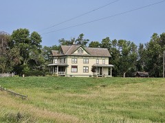 | Charles A. Barber Farmstead | district | 1988 | 88000048 |
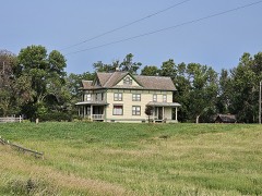 | Charles A. Barber Farmstead (Boundary Increase) | structure | 1996 | 96001226 |
 | Chilson, Chil and Julia House | building | 2020 | 100005112 |
 | Lars J. Fiksdal House | building | 1995 | 95000279 |
 | First National Bank Building | building | 2005 | 05000626 |
 | William Havens House | building | 1985 | 85000182 |
 | Anton and Mary Agnes Karpen House | building | 2008 | 08000042 |
 | Roslyn Auditorium | building | 2001 | 01000097 |
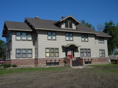 | Waddel Mansion | building | 1994 | 94000564 |
 | Waldorf Hotel | building | 1979 | 79002401 |
 | John and Kittie Williams House | building | 2008 | 08000043 |
 | Zoar Norwegian Lutheran Church | building | 1990 | 90001644 |
Every wildfire the federal occurrence database records inside this county: 129 of them, burning about 6,517 acres. 3 started naturally and 8 were recorded as arson. Each settlement page carries the fires within five miles of it.
| Reported cause | Fires |
|---|---|
| Missing data/not specified/undetermined | 53 |
| Debris and open burning | 40 |
| Equipment and vehicle use | 10 |
| Arson/incendiarism | 8 |
| Misuse of fire by a minor | 7 |
| Smoking | 5 |
| Natural | 3 |
| Fireworks | 2 |
| Recreation and ceremony | 1 |
The five largest, by the area the report gives. None of them was recorded as arson.
| Date | Cause | Size | Reported by | Name on the report |
|---|---|---|---|---|
| 21 October 2000 | Debris and open burning | 2,000 acres | Bristol Volunteer Fire Department | PHEASANT OPENER |
| 30 April 1992 | Missing data/not specified/undetermined | 1,435 acres | Waubay National Wildlife Refuge | SPRING LKE |
| 1 June 2009 | Debris and open burning | 309 acres | South Dakota Wildland Fire Suppression | not named |
| 21 May 2008 | Debris and open burning | 307 acres | South Dakota Wildland Fire Suppression | not named |
| 29 September 2001 | Equipment and vehicle use | 300 acres | Langford Volunteer Fire Department | MARK JOHNSON |
| 13 April 2002 | Debris and open burning | 212 acres | Sisseton Agency | SHEPHARD |
| 24 May 2002 | Misuse of fire by a minor | 133 acres | Sisseton Agency | BLUEDOG |
| 5 May 2008 | Debris and open burning | 132 acres | South Dakota Wildland Fire Suppression | not named |
Every settlement page carries the fires within five miles of it - see the settlement index below.
The NOAA Storm Events Database holds 456 reports for this county, causing no deaths, 15 injuries and about $3,032,330 in recorded property damage. Each settlement page carries the reports that name it.
| Kind of event | Reports |
|---|---|
| Hail | 207 |
| Thunderstorm Wind | 185 |
| Tornado | 32 |
| Flood | 18 |
| Flash Flood | 11 |
| Funnel Cloud | 3 |
The most serious of them, by death, then injury, then recorded damage. The accounts are quoted exactly as the forecast office filed them.
| When | Event | Place named | Harm | What the report says |
|---|---|---|---|---|
| July 2008 | Thunderstorm Wind | Webster | 10 hurt | The lumber yard and cabinet shop in Webster were destroyed. Power lines and poles were downed along with hundreds of trees. A semi was overturned on Highway 12 west of Webster injuring the driver. Several other injuries occurred in Day County as a result of the windstorm. The injuries were minor to moderate with scrapes and abrasions to lower back injuries and a broken collar bone. |
| July 2005 | Thunderstorm Wind | Waubay | 4 hurt | Eighty mph winds or higher destroyed a 14 by 40 foot trailer home at Enemy Swim Lake. The four occupants inside were not seriously injured. The winds also damaged the roofs of two other homes, damaged several boat lifts and docks, downed some power lines and poles, damaged the school, and downed many trees and branches. |
| June 1973 | Tornado (F1) | not stated | 1 hurt, $2,500 | no account filed |
| June 1979 | Tornado (F1) | not stated | $2,500,000 | no account filed |
| July 1996 | Tornado (F2) | Pierpont | $200,000 | no account filed |
| April 2023 | Flood | Pierpont | $150,000 | Many roadways were flooded, including 447th Avenue south of Waubay. |
| April 2019 | Flood | Pierpont | $104,300 | no account filed |
| June 1994 | Hail | not stated | $50,000 | Hail damage occured in a continuous strip with widespread crop damage. Some vehicles were damaged, receiving broken windows and dents. |
| August 2009 | Flash Flood | Andover | $10,000 | no account filed |
| July 1994 | Thunderstorm Wind | Waubay | $5,000 | Thunderstorm Winds blew down some power lines and tree limbs. |
| April 2006 | Flash Flood | Crandall | $5,000 | no account filed |
| June 1953 | Tornado (F2) | not stated | $2,500 | no account filed |
| October 1994 | Thunderstorm Wind | Grenville SD | $2,000 | Thunderstorm winds blew shingles away and caused further damage to the roof of a house, allowing water to leak into three rooms. |
| May 1994 | Hail | Roslyn | $500 | Roof shingles were ripped off of a house. |
| May 1994 | Thunderstorm Wind | Roslyn | $500 | Roof shingles were ripped off of a house. |
| June 1954 | Tornado (F1) | not stated | $30 | no account filed |
| June 2025 | Hail | Grenville | - | A trained spotter reports hail to the size of half-dollars. Their vehicles received numerous dents, along with a broken windshield. |
| June 2025 | Flood | Waubay | - | The Day county Emergency Manager sent photos of flooding of fields, ditches and with water over a portion of 148th st. |
| August 2025 | Hail | Pierpont | - | Hail up to ping pong ball size along with wind caused significant crop damage, stripped leaves from trees, and damaged shingles. |
| August 2025 | Thunderstorm Wind | Roslyn | - | The caller stated that winds, estimated at 60 mph, with nickel size hail, caused damage to crops. |
| August 2025 | Thunderstorm Wind | Roslyn | - | The Fire Department in Roslyn reported numerous trees down in town. |
| August 2025 | Thunderstorm Wind | Roslyn | - | A trained spotter reported thunderstorm winds damaged the awning on a camper trailer. |
| August 2025 | Flood | Roslyn | - | Heavy rain caused water to run over South Dakota Highway 27 one mile south of Pierpont. Water was also reported over 422nd ave, 3 miles east of Pierpont, where a vehicle hydroplaned into the ditch. One of the rural county roads 5 miles southeast of Pierpont was partly washed out. Roadside ditches were full across the better part of northwest and north central Day county, with water overtopping several additional roads. 3.6 inches of rainfall was measured 6 miles east southeast of Pierpont by a resident, while a trained spotter 1 mile south of Roslyn recorded 4.64 inches. A resident 7 miles west of Roslyn would go on to estimate they received 5 inches of total rainfall. |
| August 2025 | Flood | Pierpont | - | The Marshall County Emergency Manager reported flooding on multiple roads located south of Langford in Day county. Flooding was also reported along the creek located near the Back Forty Beef Farm, 5 miles southeast of Pierpont. |
| August 2023 | Thunderstorm Wind | Webster Muni Arpt | - | A trained spotter reported wind damage to his corn field. |
| May 2022 | Thunderstorm Wind | Webster Muni Arpt | - | A trained spotter reported estimated 70 mph wind gusts and tree damage. |
| May 2022 | Thunderstorm Wind | Grenville | - | Tree branches were downed by severe winds. |
| May 2022 | Thunderstorm Wind | Grenville | - | Straight-line winds damaged the side of a farm building by removing a few panels. |
| May 2022 | Thunderstorm Wind | Webster Muni Arpt | - | Several roof panels were lifted off a farm building. |
| May 2022 | Tornado (EF1) | Webster Muni Arpt | - | A tornado 7 miles to the south-southeast of Webster hit an|outbuilding, pulling the roof off and knocking over the interior|wall. The debris from the building was carried to the northwest|for over 250 yards and spread out to the west. A calving shed was|rolled to the north and then northwest. A animal trailer was|tipped over and a metal windmill was knocked over and twisted. |
| June 2022 | Thunderstorm Wind | Lily | - | The wind was recorded by a personal weather station. |
| June 2022 | Hail | Waubay | - | The report was relayed via social media. |
| May 2022 | Thunderstorm Wind | Webster Muni Arpt | - | A barn was destroyed by estimated 80 mph wind gusts. |
| August 2021 | Tornado (EF0) | Webster Muni Arpt | - | A brief touchdown of a tornado occurred with no damage reported. |
| August 2021 | Hail | Butler | - | A satellite depicted hail swath from a severe thunderstorm that started in Edmunds County across southern Brown County entered Day County continuing its crop damage. The storm weakened as it moved into Roberts County. The scar dimensions covered approximately 60 square miles in Day County. |
| August 2021 | Hail | Butler | - | Windshields were broken and tree damage occurred from two inch hail. |
| October 2021 | Tornado (EF0) | Roslyn | - | The fire department reported a brief tornado touchdown. |
| October 2021 | Thunderstorm Wind | Roslyn | - | The fire department reported trees down in Roslyn due to 60 to 70 mph estimated winds. |
| October 2021 | Thunderstorm Wind | Roslyn | - | Several trees were downed by estimated 70 mph winds. |
| June 2021 | Thunderstorm Wind | Andover | - | A farm shop lost its roof from winds near 70 mph. |
| July 2020 | Thunderstorm Wind | Webster | - | Estimated seventy mph winds downed several trees in Webster. |
| July 2020 | Thunderstorm Wind | Grenville | - | Estimated seventy mph winds flipped a pontoon and downed a tree at Pickerel Lake. |
| August 2020 | Thunderstorm Wind | Waubay | - | Sixty mph winds were estimated. |
| June 2020 | Thunderstorm Wind | Bristol | - | Estimated ninety mph winds destroyed a machine shed. |
| June 2020 | Thunderstorm Wind | Bristol | - | Seventy-five mph winds downed several trees and power lines in Bristol. |
| June 2020 | Thunderstorm Wind | Webster Muni Arpt | - | Sixty mph winds were estimated. |
| June 2020 | Thunderstorm Wind | Webster Muni Arpt | - | Sixty mph winds were estimated. |
| March 2019 | Flood | Pierpont | - | Snowmelt flooding resulted in fifteen roads covered by water from overwhelmed culverts. |
| August 2019 | Flood | Pierpont | - | Several homes on Blue Dog Lake on the north side of Waubay became surrounded by water. Water was up against seven or eight homes. Much of the sandbags placed earlier were underwater. Many roads were saturated or underwater in Day county. |
| July 2019 | Thunderstorm Wind | Pierpont | - | Some tree branches were downed. |
| September 2019 | Tornado (EF1) | Bristol | - | The tornado touched down in a field west of 424th Ave, crossed the road and tracked along the northern edge of a farmstead 4 miles north of Bristol. Multiple broken tree branches were noted, with some tossed 50 to 80 yards from the original source. One fiberglass shed was destroyed and tossed about 70 yards. Another outbuilding was lifted off the foundation and set down about 30 yards away. The tornado continued east of the farmstead, crossing two small lakes. The track was clearly shown by cattails flattened in a convergent pattern. The tornado then struck another tree with limbs broken and tossed. The final evidence of the tornado was a downed deer stand. |
| September 2019 | Tornado (EF0) | Webster | - | A witness observed a tornado touch down over a lake and then track onto a pasture before lifting. No damage occurred. |
| September 2019 | Tornado (EF0) | Bristol | - | Witnesses observed a tornado. Additional evidence of the touchdown was an area of convergent pattern-flattened cattails. |
| July 2018 | Thunderstorm Wind | Waubay | - | Seventy mph winds tipped over two campers with one rolling at Bitter Lake Lodge. |
| June 2018 | Thunderstorm Wind | Webster Muni Arpt | - | Two trees were snapped by an estimated eighty mph wind. |
| July 2018 | Thunderstorm Wind | Roslyn | - | Estimated sixty mph winds occurred. |
| July 2018 | Thunderstorm Wind | Roslyn | - | Sixty mph winds occurred again with another thunderstorm in Roslyn. |
| June 2017 | Thunderstorm Wind | Holmquist | - | Ninety mph winds or higher downed numerous trees with a storage shed completely destroyed. |
| June 2017 | Thunderstorm Wind | Holmquist | - | Several power poles were downed by an estimated ninety mph winds. |
| June 2017 | Thunderstorm Wind | Webster | - | An estimated seventy-five mph wind downed several power lines in Webster. |
The Survey's mineral resources record lists 9 workings inside this county. 7 still produce and 2 are closed or unrecorded. Each settlement page carries the workings within five miles of it.
| Commodity | Workings |
|---|---|
| Sand and Gravel, Construction | 9 |
The least common of them first, because a county's hundredth gravel pit says nothing its first ten did not.
| Where | Site | Commodity | Status | Recorded |
|---|---|---|---|---|
| Day County Pit | Sand and Gravel, Construction | Producer | ||
| Donahue Sand & Gravel Pit | Sand and Gravel, Construction | Producer | ||
| Ellington Pit | Sand and Gravel, Construction | Producer | ||
| Gaikowski Pit | Sand and Gravel, Construction | Producer | ||
| Gravel Pit | Sand and Gravel, Construction | Past Producer | ||
| Gronke Pit | Sand and Gravel, Construction | Producer | ||
| Lesner Pit | Sand and Gravel, Construction | Producer | ||
| Opitz Pit | Sand and Gravel, Construction | Past Producer | ||
| Opitz Pit #2 | Sand and Gravel, Construction | Producer |
Named settlements recorded in the Geographic Names Information System, each with the topographic sheets covering it. Villages, hamlets and abandoned places alike. Each is shown with the nearest named watercourse or landform and the survey quadrangle it falls on.