 Block
From the record
10 National Register listings published here.
Sources: the county history on the Internet Archive · the National Register database, National Park Service
39 topographic sheets cover 18 settlements here, and 10 properties are on the National Register of Historic Places.
10 National Register listings published here.
Sources: the county history on the Internet Archive · the National Register database, National Park Service
Every property in this county listed on the National Register of Historic Places, with the year it was listed and the federal nomination document.
| Photograph | Property | Type | Listed | Reference |
|---|---|---|---|---|
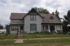 | Gov. Frank M. Byrne House | building | 1992 | 91002044 |
| Dr. William Edgerton House | building | 2010 | 10000951 | |
 | Faulk County Courthouse | building | 1993 | 92001857 |
 | Faulkton American Legion Hall | building | 2005 | 05000034 |
| C.W. Parker Carousel No. 825 | structure | 2017 | 100001399 | |
| Maj. John A. Pickler Homestead | building | 1973 | 73001742 | |
| Sievers School | building | 2014 | 14000031 | |
| South Dakota Dept. of Transportation Bridge No. 25-218-141 | structure | 1993 | 93001288 | |
| South Dakota Dept. of Transportation Bridge No. 25-380-142 | structure | 1993 | 93001262 | |
 | Frank and Clara Turner House | building | 1986 | 86000245 |
Every wildfire the federal occurrence database records inside this county: 58 of them, burning about 2,572 acres. 17 started naturally and 1 was recorded as arson. Each settlement page carries the fires within five miles of it.
| Reported cause | Fires |
|---|---|
| Natural | 17 |
| Missing data/not specified/undetermined | 16 |
| Debris and open burning | 12 |
| Equipment and vehicle use | 11 |
| Smoking | 1 |
| Arson/incendiarism | 1 |
The five largest, by the area the report gives. None of them was recorded as arson.
| Date | Cause | Size | Reported by | Name on the report |
|---|---|---|---|---|
| 19 March 2004 | Debris and open burning | 650 acres | South Dakota Wildland Fire Suppression | GROTTLE BROS. |
| 5 August 2005 | Debris and open burning | 600 acres | South Dakota Wildland Fire Suppression | DEITER BROTHERS |
| 16 July 2006 | Natural | 250 acres | South Dakota Wildland Fire Suppression | not named |
| 16 July 2006 | Natural | 150 acres | South Dakota Wildland Fire Suppression | not named |
| 3 August 2006 | Natural | 100 acres | South Dakota Wildland Fire Suppression | not named |
| 11 October 2015 | Equipment and vehicle use | 100 acres | South Dakota Wildland Fire Suppression | RICK RAUSCH |
| 30 July 2006 | Missing data/not specified/undetermined | 80 acres | South Dakota Wildland Fire Suppression | not named |
| 3 August 2006 | Natural | 75 acres | South Dakota Wildland Fire Suppression | not named |
Every settlement page carries the fires within five miles of it - see the settlement index below.
The NOAA Storm Events Database holds 366 reports for this county, causing no deaths, no injuries and about $388,600 in recorded property damage. Each settlement page carries the reports that name it.
| Kind of event | Reports |
|---|---|
| Hail | 193 |
| Thunderstorm Wind | 130 |
| Tornado | 21 |
| Flood | 9 |
| Flash Flood | 7 |
| Funnel Cloud | 6 |
The most serious of them, by death, then injury, then recorded damage. The accounts are quoted exactly as the forecast office filed them.
| When | Event | Place named | Harm | What the report says |
|---|---|---|---|---|
| April 2023 | Flood | Onaka | $150,000 | no account filed |
| April 2019 | Flood | Onaka | $121,100 | no account filed |
| July 1994 | Thunderstorm Wind | Miranda to Doland | $50,000 | Thunderstorm Winds caused widespread tree damage and undetermined crop damage. |
| June 1957 | Tornado (F3) | not stated | $25,000 | no account filed |
| June 1952 | Tornado | not stated | $25,000 | no account filed |
| September 1999 | Flash Flood | Seneca | $10,000 | no account filed |
| August 1985 | Tornado (F1) | not stated | $2,500 | no account filed |
| April 1973 | Tornado (F2) | not stated | $2,500 | no account filed |
| July 1966 | Tornado (F2) | not stated | $2,500 | no account filed |
| June 2025 | Thunderstorm Wind | Chelsea | - | Caller states that some shingles were blown from the roof. |
| July 2025 | Hail | Cresbard | - | Hail with a diameter of 3.5 inches was measured five miles north of Cresbard. |
| July 2025 | Hail | Cresbard | - | Baseball-sized hail was reported near Chelsea, causing damage to vehicles, siding, and nearby crops. |
| July 2025 | Thunderstorm Wind | Chelsea | - | Thunderstorm winds estimated at 60 mph and large hail resulted in stripped siding and damage to surrounding crops. |
| August 2025 | Thunderstorm Wind | Faulkton Muni Arpt | - | The COOP observer 1 mile west of Faulkton estimated thunderstorm wind gusts at around 60 mph. |
| May 2024 | Funnel Cloud | Chelsea | - | A trained spotter observed a funnel cloud west of Warner. |
| June 2024 | Tornado (EF0) | Onaka | - | A tornado briefly touched down in a field, and was later confirmed by satellite. |
| April 2022 | Thunderstorm Wind | Cresbard | - | Estimated 70+ mph winds moved a grain cart around 15 feet. |
| August 2022 | Thunderstorm Wind | Chelsea | - | An out building was blown through a windbreak and across the road, and another building had its north doors blown out by estimated 80 mph winds. |
| June 2022 | Thunderstorm Wind | Norbeck | - | The wind was recorded by a personal weather station. |
| August 2022 | Thunderstorm Wind | Faulkton | - | An elm tree was snapped, and several 2 to 4 inch diameter branches were downed by estimated 70 mph winds. |
| July 2022 | Flash Flood | Faulkton Muni Arpt | - | A trained spotter reported a four mile stretch of County Road 11 south of Faulkton was closed due to high flood waters. |
| June 2022 | Thunderstorm Wind | Onaka | - | Winds were estimated to be between 50 and 60 mph, the timing of which was based on radar. |
| May 2021 | Thunderstorm Wind | Orient | - | Multiple grain bins were blown over by estimated 80 mph winds. |
| July 2020 | Thunderstorm Wind | Chelsea | - | Estimated seventy mph winds scattered several chemical bulk containers about the yard. |
| July 2020 | Thunderstorm Wind | Faulkton Muni Arpt | - | Estimated sixty mph winds brought down several large tree branches along with a dead tree. The dead tree fell onto a building. |
| August 2020 | Hail | Burkmere | - | Golf ball hail stripped some leaves off some beans. |
| June 2020 | Tornado (EF1) | Seneca | - | West of South Dakota Highway 47, minor roof damage occurred to a house, a calving shed was pushed 10 feet to the northeast and sheet metal from a barn was tossed across the highway to the east northeast into an open field. On the main property, damage was done to a dog kennel, a tree was uprooted, pine trees were snapped at the trunk and stripped of needles, fencing was leveled, and a batting cage and playhouse were tossed. Further northeast several calf sheds were moved or rolled. One calving shed was lofted into the air over a grove of trees. |
| June 2020 | Tornado (EF1) | Burkmere | - | A pole barn was completely destroyed with anchoring poles pulled straight up out of the ground. A second well anchored outbuilding was ripped off of its foundation while a third outbuilding was tossed. Debris from all three destroyed buildings was spread between one half to three quarters of a mile to the northeast across an open field. Debris lumber from the buildings was pierced into the ground. Some fencing was damaged and farm equipment was pushed and tipped over. The main house suffered shingle and siding damage. |
| June 2020 | Thunderstorm Wind | Burkmere | - | Several buildings were damaged by an estimated eighty mph wind. |
| June 2020 | Thunderstorm Wind | Burkmere | - | Estimated eighty mph winds destroyed two greenhouses, damaged the siding on the house, and broke a window. The winds also tipped over an auger and other equipment along with denting a hopper bin. |
| June 2020 | Thunderstorm Wind | Seneca | - | Several buildings were damaged by estimated seventy mph winds. |
| June 2020 | Thunderstorm Wind | Faulkton | - | A tree was downed by estimated seventy mph winds. |
| June 2020 | Thunderstorm Wind | Faulkton | - | Several power poles and lines were downed by estimated eighty mph winds along with many large tree limbs. |
| March 2019 | Flood | Onaka | - | Several county and township roads were flooded. |
| July 2019 | Thunderstorm Wind | Miranda | - | Sixty mph winds were estimated. |
| July 2019 | Thunderstorm Wind | Onaka | - | Estimated seventy mph winds tore many shingles off the roof. |
| July 2018 | Hail | Millard | - | Large hail damaged many acres of corn and beans. |
| July 2018 | Hail | Orient | - | Golf ball hail damaged many acres of corn and beans. |
| July 2018 | Hail | Onaka | - | Quarter hail damaged the bean crop and peeled paint of a building. |
| June 2018 | Thunderstorm Wind | Onaka | - | Estimated one-hundred mph winds knocked over a concrete grain silo, totaled a pole barn, and caused extensive tree damage. |
| June 2018 | Thunderstorm Wind | Wecota | - | A machine shed was partially destroyed along with several grain bins damaged by estimated ninety mph winds. |
| June 2018 | Thunderstorm Wind | Cresbard | - | Severe winds of over ninety mph damaged several buildings and grain bins along with downing multiple power poles. |
| June 2018 | Thunderstorm Wind | Chelsea | - | An estimated eighty mph wind from a thunderstorm brought down a tree. Before the rain began, blowing dust occurred with the visibility down to an eighth of a mile. |
| June 2018 | Thunderstorm Wind | Faulkton | - | A large tree was uprooted by an estimated seventy mph wind. |
| June 2018 | Thunderstorm Wind | Faulkton | - | Estimated seventy mph winds brought many tree branches down along with knocking out power for about half of Faulkton. |
| July 2017 | Thunderstorm Wind | Wecota | - | Seventy mph winds downed a tree along with many large tree branches. The winds combined with tennis ball hail caused damage to windows and crops. |
| September 2016 | Hail | Zell | - | Hail caused some minor damage to the bean crop. |
| July 2016 | Thunderstorm Wind | Rockham | - | Sixty mph winds were estimated. |
| July 2016 | Thunderstorm Wind | Miranda | - | Seventy mph winds downed four power poles along with causing some crop damage. |
| July 2015 | Hail | Chelsea | - | A large area of crops were damaged from golf ball size hail. |
| July 2015 | Thunderstorm Wind | Cresbard | - | Sixty mph winds downed several tree branches. |
| July 2015 | Thunderstorm Wind | Chelsea | - | Sixty mph winds were estimated. |
| June 2014 | Thunderstorm Wind | Faulkton | - | Sixty mph winds were estimated. |
| June 2014 | Flash Flood | Cresbard | - | Very heavy rains of around 3 inches flooded a township road for several hours. |
| August 2014 | Tornado (EF0) | Wecota | - | A tornado touched down about a mile south of Highway 20 and tracked northward to about a mile north of Highway 20. The tornado tracked mainly across open country and caused only minor tree damage near a home. |
| August 2014 | Tornado (EF0) | Wecota | - | The tornado touched down about a mile south of Highway 20 and traveled over four miles to the northeast before lifting. The tornado caused minor damage to two farms. A garage door was blown over the roof of the garage along with tree damage. A livestock trailer was also blown over along with more tree damage at the second farm. |
| June 2014 | Tornado (EF0) | Cresbard | - | A tornado was confirmed by aerial photography from a local pilot. The tornado scoured a path through some crops. |
| June 2013 | Thunderstorm Wind | Cresbard | - | Sixty mph winds were estimated. |
| May 2012 | Thunderstorm Wind | Cresbard | - | Sixty mph winds downed some large tree limbs. |
| May 2012 | Thunderstorm Wind | Cresbard | - | Sixty mph winds were estimated by the public. |
The Survey's mineral resources record lists 1 working inside this county. It still produces. Each settlement page carries the workings within five miles of it.
| Commodity | Workings |
|---|---|
| Sand and Gravel, Construction | 1 |
The least common of them first, because a county's hundredth gravel pit says nothing its first ten did not.
| Where | Site | Commodity | Status | Recorded |
|---|---|---|---|---|
| Heber Pit | Sand and Gravel, Construction | Producer |
History of Faulk County, South Dakota, Together with Biographical Sketches of Pioneers and Prominent Citizens devotes a chapter to each township: its boundaries and streams, who settled it and when, the mills, the schools and the churches. All 6 are reproduced here in full. Each row shows the township's own shape and where it lies in the county, drawn from the Census Bureau's boundary. Which settlements belong to which township is computed from that same boundary, not taken from the book.
| Shape and position in the county | Township | Settlements in it | Length | Sections |
|---|---|---|---|---|
| Devoe Township | Devoe | 256 words | 0 | |
| Orient Town | Orient | 378 words | 2 | |
| Rockham Town | Rockham | 306 words | 1 | |
| Saratoga Township | Brentwood Colony | 24 words | 0 | |
| Seneca Town | Seneca | 113 words | 0 | |
| Zell Township | Zell | 351 words | 0 |
One book written about this county, cut here where the book itself is cut, at its printed chapters: 15 chapters in all. Every chapter is public domain, machine-read from the scan and reproduced complete. A chapter already given under one of the county's towns is not repeated in this list.
| Chapter | Length |
|---|---|
| Chapter 1: Introductory | 1,207 words |
| Chapter 2: Vstate History | 5,851 words |
| Chapter 5: The First Settiver | 704 words |
| Chapter 7: The Bivizzard of Jan. 12, 1888 | 1,853 words |
| Chapter 9: The Western Third of the County | 977 words |
| Chapter 12: New Social Relations | 983 words |
| Chapter 14: The Donation of a Church Bei.l | 654 words |
| Chapter 16: Educational | 540 words |
| Chapter 18: F^auivk County in 1908 | 1,322 words |
| Chapter 19: From County Commissioner's Record | 3,160 words |
| Chapter 21: Eari.y History | 448 words |
| Chapter 27: Social Organization | 2,506 words |
| Chapter 28: Church Organization | 1,635 words |
| Chapter 29: The Woman Suffrage Question | 5,747 words |
| Chapter with an unread heading (no. 15 of those read) | 43,828 words in 3 parts |
Named settlements recorded in the Geographic Names Information System, each with the topographic sheets covering it. Villages, hamlets and abandoned places alike. Each is shown with the nearest named watercourse or landform and the survey quadrangle it falls on.