 Block
From the record
15 National Register listings published here.
Sources: the National Register database, National Park Service
13 topographic sheets cover 10 settlements here, and 15 properties are on the National Register of Historic Places.
15 National Register listings published here.
Sources: the National Register database, National Park Service
Every property in this county listed on the National Register of Historic Places, with the year it was listed and the federal nomination document.
| Photograph | Property | Type | Listed | Reference |
|---|---|---|---|---|
| Big Stone City Hall | building | 2004 | 04000764 | |
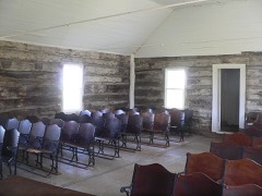 | Brown Earth Presbyterian Church | building | 1984 | 84003288 |
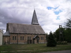 | First Congregational Church of Milbank | building | 1978 | 78002553 |
 | First National Bank of Milbank | building | 1978 | 78002554 |
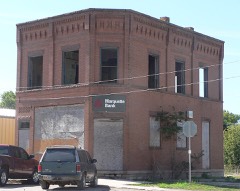 | First State Bank Building | building | 1987 | 87000221 |
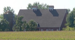 | Herman Friewald Barn | building | 2008 | 08000045 |
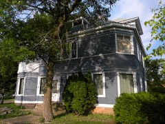 | James A. and Ida Bell Gold House | building | 2008 | 08000046 |
 | Grant County Courthouse | building | 1993 | 92001858 |
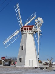 | Hollands Grist Mill | structure | 1981 | 81000573 |
 | Emil and Hannah Johnson House | building | 2008 | 08000047 |
| George and Mary Koch Farm | district | 2008 | 08000048 | |
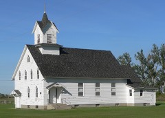 | Lebanon Lutheran Church | building | 1977 | 77001244 |
 | Milbank Carnegie Library | building | 1978 | 78002555 |
 | Ole Nelson Barn | building | 2008 | 08000049 |
 | Swedish Lutheran Church of Strandburg | building | 1978 | 78002556 |
Every wildfire the federal occurrence database records inside this county: 59 of them, burning about 383 acres. None started naturally and 1 was recorded as arson. Each settlement page carries the fires within five miles of it.
| Reported cause | Fires |
|---|---|
| Missing data/not specified/undetermined | 44 |
| Debris and open burning | 9 |
| Railroad operations and maintenance | 4 |
| Equipment and vehicle use | 1 |
| Arson/incendiarism | 1 |
The five largest, by the area the report gives. One of them was set deliberately.
| Date | Cause | Size | Reported by | Name on the report |
|---|---|---|---|---|
| 4 November 2020 | Debris and open burning | 70 acres | South Dakota Wildland Fire Suppression | not named |
| 5 May 2008 | Debris and open burning | 50 acres | South Dakota Wildland Fire Suppression | not named |
| 6 November 2020 | Missing data/not specified/undetermined | 43 acres | Waubay Wetland Management District | SDWDR-FY21-WF-STREICH |
| 23 August 2000 | Debris and open burning | 40 acres | South Shore Volunteer Fire Department | MIETIS |
| 13 May 2015 | Missing data/not specified/undetermined | 20 acres | South Dakota Wildland Fire Suppression | LODGE FIRE |
| 23 April 1999 | Arson/incendiarism | 17 acres | Waubay National Wildlife Refuge | VANHOUT |
| 6 March 2000 | Missing data/not specified/undetermined | 12 acres | South Shore Volunteer Fire Department | WILLIS PALMER |
| 11 April 2011 | Missing data/not specified/undetermined | 10 acres | South Dakota Wildland Fire Suppression | BERG |
Every settlement page carries the fires within five miles of it - see the settlement index below.
The NOAA Storm Events Database holds 281 reports for this county, causing no deaths, 2 injuries and about $1,059,800 in recorded property damage. Each settlement page carries the reports that name it.
| Kind of event | Reports |
|---|---|
| Hail | 128 |
| Thunderstorm Wind | 83 |
| Flood | 25 |
| Tornado | 22 |
| Flash Flood | 14 |
| Lightning | 5 |
| Funnel Cloud | 3 |
| Wildfire | 1 |
The most serious of them, by death, then injury, then recorded damage. The accounts are quoted exactly as the forecast office filed them.
| When | Event | Place named | Harm | What the report says |
|---|---|---|---|---|
| July 2008 | Thunderstorm Wind | Milbank | 2 hurt | Many trees were downed throughout the city of Milbank. Two semis were blown off of Highway 12 near Milbank resulting in injuries to the drivers. |
| June 2008 | Flash Flood | Hiland | $250,000 | no account filed |
| August 1981 | Tornado (F1) | not stated | $250,000 | no account filed |
| April 2023 | Flood | Hiland | $150,000 | no account filed |
| June 2013 | Thunderstorm Wind | Milbank | $131,000 | Eighty mph winds caused major tree and structural damage in and around Milbank. Many trees were downed. |
| April 2019 | Flood | Hiland | $75,800 | no account filed |
| May 1994 | Hail | Strandburg | $50,000 | The hail broke windows, and damaged shingles, siding, and vehicles. There was undetermined crop damage. |
| July 1994 | Hail | Labolt | $50,000 | no account filed |
| July 2013 | Flash Flood | Hiland | $40,000 | no account filed |
| August 1955 | Tornado (F2) | not stated | $25,000 | no account filed |
| March 2009 | Flash Flood | Marvin | $20,000 | Flash flooding damaged a bridge along with several township roads in Grant county. |
| August 2017 | Lightning | Milbank | $10,000 | Lightning blew out a transformer which snapped a power pole and downed some power lines in Milbank. |
| May 1977 | Tornado | not stated | $2,500 | no account filed |
| May 1973 | Tornado (F1) | not stated | $2,500 | no account filed |
| August 2007 | Lightning | Milbank | $2,000 | Lightning struck a home in Milbank damaging some of the siding, sheet rock, electrical wiring and outlets, and blew a chunk of cement out of the basement. |
| October 1994 | Thunderstorm Wind | Milbank SD | $1,000 | Thunderstorm winds damaged a commercial building under construction. |
| June 2025 | Flood | Milbank | - | The Milbank COOP observer reported standing water in farm fields between Milbank and Twin Brooks. |
| June 2025 | Flood | Hiland | - | A resident of Grant county submitted photos of their flooded homestead including water over the road and up to the foundation of the residence. |
| August 2025 | Flood | Milbank Arpt | - | The river crested at 1059.7 feet, or 3.7 feet above flood stage, at 2:00 p.m. CST on August 7th. At its peak, the water reached just shy of the bottom of the bridges on 145th Street and 480th Avenue. The low water crossing on 479th Avenue was flooded, along with nearby agricultural lands. |
| May 2023 | Tornado (EF0) | Labolt | - | A storm chaser posted photos of a rope tornado moving through pasture and an open field. The tornado may have clipped some trees as well before dissipating. |
| April 2023 | Flood | Milbank Arpt | - | The South Fork Whetstone River gauge near Milbank peaked just above flood stage at 1113.83 feet, with water reaching the bottom of the bridge on 148th Street. Otherwise the impact was mainly to agricultural lands. |
| April 2023 | Flood | Big Stone City | - | The Whetstone River gauge above Big Stone City recorded a peak of 19.65 feet on April 13th, which is just below major flood stage. |
| April 2023 | Flood | Milbank Arpt | - | The North Fork Whetstone River gauge near Milbank peaked in moderate flood stage at 1062.40 feet on the evening of April 15th, with water crossing over 479th Avenue and topping the bridge on 144th Street. Additionally water reached the bridges at 145th Street and 480th Avenue. At this intersection, a vehicle drove into flood waters and drifted down river, initiating a multi agency water rescue. Additionally, significant amounts of agricultural land was flooded. |
| April 2023 | Flood | Hiland | - | Big Sioux river near Florence peaked in major flood stage at 9.58 feet in the early morning hours of April 13th. This is a record flood stage for this location. Being the headwaters of the Big Sioux the main impacts were to local and county roads and bridges as well as agricultural lands. |
| May 2022 | Tornado (EF1) | Twin Brooks | - | Roughly 300 yards to the south of the farm a calf shed was picked|up and lofted to the north, over the shelterbelt on the south|side of the property. The calf shed would land in the feed lot|area and pushed up against a barn. A stave silo was moved off the|foundation about a foot, but otherwise remained erect. A pole barn |was severely damaged, with the west wall collapsed and the south wall|pushed in. A wood grain bin shifted off the foundation and was|pushed 300 feet to the north. Two empty grain bins were|destroyed. One tossed into a creek on the north end of the|property. The second was destroyed and lofted. A cattle trailer|at the same location was pushed about 100 feet before it was|rolled into the creek. Pieces of debris from the farm would be|found across Highway 12 and over a mile to the north northeast of|the property. |
| May 2022 | Tornado (EF1) | Albee | - | The south to north tornado track started south of 156th St along 482nd Ave where a farm exhibited clear tornado damage which included mangled trees, barn roof damage, barn doors split in half, residential roof and siding damage and a camper completely destroyed. The track would continue roughly three miles north in the vicinity of 153rd St. Another farm would sustain damage, with tops of trees missing in one shelterbelt and uprooted and snapped trees in a second shelterbelt. The dormer of the residence was ripped off and landed 85 to 100 yards from the house in a northeast direction. North of this property a dairy farm had a machine shed with collapsed walls. This farm was housing dairy cattle that were transported from the Estelline area after a May 12 tornado destroyed barns on that property. The last indication of the tornado track was through a shelter belt a quarter mile north of 153rd St. |
| May 2022 | Thunderstorm Wind | Big Stone City | - | The roof of a Big Stone City business was blown off, and parts of it ended up in a tree about 360 feet to the north by estimated 80 mph winds. |
| May 2022 | Thunderstorm Wind | Hiland | - | Winds damaged building doors and shingles, and downed trees. A nearby weather station reported 84 mph wind gusts. |
| May 2022 | Tornado (EF1) | Labolt | - | Two properties near the intersection of 164th St and 475th Ave sustained damage. The first farm had a roof ripped off a barn, damage to a machine shed, a destroyed stave silo, debris pierced through house walls, roof panels off house, broken house windows, snapped and uprooted trees, and a dented grain bin. The second residence had half a barn roof ripped off and tossed a quarter mile to the northeast. The track continued northeast roughly six miles, crossing Grant County Highway 15, between 158th St and 159th St. Near this location a farmstead sustained complete loss of a machine shed and power lines were downed. The track would come to an end roughly two more miles to the northeast near 157th St, where another farm would sustain complete loss to a machine shed and debris spread across the field to the north northeast. |
| May 2022 | Thunderstorm Wind | Labolt | - | Severe winds downed multiple trees and blew over a shed. |
| May 2022 | Tornado (EF1) | Albee | - | The southwest half of a machine shed shop was completely|destroyed. The north side remained upright and on the foundation,|however garage doors and entry doors no longer close properly due|to a counter clockwise twisting of the frame. 2x12 rafters from|the machine shed were launched through the walls of a nearby shed. |Another shed on the property also lost one third of its roof. |Debris from the buildings was spread to the northeast with large |pieces of wood pierced vertically into the ground along the track. |Debris was tossed northeast between one quarter and one half mile |from the farm. |
| June 2022 | Thunderstorm Wind | Milbank | - | Significant straight-line wind snapped and uprooted many trees at the cemetery northeast of Milbank. It also destroyed a two-stall shed and another outbuilding had roof damage. |
| September 2022 | Hail | Strandburg | - | The timing and location of the report are approximated. |
| August 2021 | Thunderstorm Wind | Hiland | - | Estimated wind speeds of 65 mph occurred. |
| July 2020 | Thunderstorm Wind | Marvin | - | Six grain bins received considerable denting from estimated seventy-five mph winds. |
| August 2020 | Thunderstorm Wind | Big Stone City | - | Estimated sixty mph winds brought down several large tree limbs. |
| June 2020 | Thunderstorm Wind | Marvin | - | A semi was blown over on Interstate-29. No injuries were reported. |
| June 2020 | Thunderstorm Wind | Troy | - | Sixty mph winds were estimated. |
| March 2019 | Flood | Hiland | - | Many county and township roads went underwater and were closed. |
| July 2018 | Thunderstorm Wind | Revillo | - | Sixty mph winds were estimated. |
| June 2018 | Thunderstorm Wind | Albee | - | Sixty-five mph winds were estimated. |
| June 2018 | Flash Flood | Albee | - | Heavy rains of 3 to 6 inches over a short period of time caused flash flooding from the Albee area to the Revillo area. There was overland flooding along with several roads flooded with a road closure. |
| June 2018 | Thunderstorm Wind | Twin Brooks | - | Sixty mph winds were estimated. |
| June 2017 | Thunderstorm Wind | Milbank | - | A large section of the roof on a dairy barn was blown off by estimated eighty to ninety mph winds. |
| June 2017 | Thunderstorm Wind | Milbank | - | Multiple trees were downed by estimated seventy to eighty mph winds along with many electrical lines downed. A few fires were started by the electrical lines. |
| June 2017 | Thunderstorm Wind | Albee | - | Three large trees were downed by an estimated eighty mph winds. |
| August 2017 | Flash Flood | Twin Brooks | - | Very heavy rains brought a creek out of its banks with flooding over the road. |
| August 2017 | Hail | Milbank | - | Hail covered the entire highway. |
| August 2016 | Thunderstorm Wind | Milbank | - | Sixty mph winds were estimated. |
| June 2015 | Thunderstorm Wind | Hiland | - | Sixty mph winds downed some tree branches. |
| August 2015 | Thunderstorm Wind | Marvin | - | Sixty mph winds were estimated. |
| July 2015 | Hail | Marvin | - | Nickel size hail damaged some nearby corn. |
| July 2015 | Thunderstorm Wind | Marvin | - | Sixty mph winds were estimated. |
| June 2014 | Flash Flood | Milbank | - | Numerous county roads were over topped around Milbank along with a few culverts being washed out. A quick 2 to 3 inches of rain brought on the flash flooding. |
| August 2014 | Flash Flood | Milbank | - | Very heavy rains of 4 to over 5 inches resulted in the flash flooding of a few roads north of Milbank. One road was closed for a time due to flash flooding. |
| June 2013 | Thunderstorm Wind | Twin Brooks | - | Several trees were downed along with many tree branches south of Corona. |
| June 2013 | Thunderstorm Wind | Milbank | - | Major tree and structural damage occurred in and around Milbank from eighty mph winds. |
| June 2013 | Thunderstorm Wind | Albee | - | Seventy mph winds caused some minor barn and machine shed roof damage. |
| June 2013 | Thunderstorm Wind | Milbank | - | A lot of tree damage occurred along State Highway 15 into Milbank. |
| June 2013 | Flash Flood | Marvin | - | Over three inches of rain caused water to go over a part of Highway 123 south of Wilmot. |
The Survey's mineral resources record lists 35 workings inside this county. 19 still produce and 16 are closed or unrecorded. Each settlement page carries the workings within five miles of it.
| Commodity | Workings |
|---|---|
| Sand and Gravel, Construction | 20 |
| Granite | 15 |
The least common of them first, because a county's hundredth gravel pit says nothing its first ten did not.
| Where | Site | Commodity | Status | Recorded |
|---|---|---|---|---|
| American Rose Quarry | Granite | Producer | ||
| B F Coggins Granite Co Pit | Granite | Past Producer | ||
| Carnelian No 1 Quarry | Granite | Producer | ||
| Cold Spring Granite Co Quarry | Granite | Producer | ||
| Columbia Granite Quarry | Granite | Producer | ||
| D G Kaddez and Co Quarry | Granite | Past Producer | ||
| Dakota Granite Co Quarry North | Granite | Producer | ||
| Dakota Granite Co South Quarry | Granite | Past Producer | ||
| Delano Granite Quarry | Granite | Past Producer | ||
| Hunter Granite Quarry | Granite | Producer | ||
| Mahogany Quarry | Granite | Producer | ||
| Melrose Granite Quarry | Granite | Producer | ||
| North Star Granite Quarry | Granite | Producer | ||
| Sequoya Quarry | Granite | Producer | ||
| Steiner Rausch Granite Pit | Granite | Producer | ||
| Big Stone Sand and Gravel Pit | Sand and Gravel, Construction | Producer | ||
| Big Tom Hill Gravel Pit | Sand and Gravel, Construction | Past Producer | ||
| Concrete Materials Co Pit | Sand and Gravel, Construction | Producer | ||
| Fiebelcrn Pit | Sand and Gravel, Construction | Producer | ||
| Gravel Pit | Sand and Gravel, Construction | Past Producer | ||
| Gravel Pit | Sand and Gravel, Construction | Past Producer | ||
| Gravel Pit | Sand and Gravel, Construction | Past Producer | ||
| Gravel Pit | Sand and Gravel, Construction | Past Producer | ||
| Gravel Pit | Sand and Gravel, Construction | Past Producer | ||
| Gravel Pit | Sand and Gravel, Construction | Past Producer | ||
| Gravel Pit | Sand and Gravel, Construction | Past Producer | ||
| Gravel Pit | Sand and Gravel, Construction | Past Producer | ||
| Gravel Pit | Sand and Gravel, Construction | Past Producer | ||
| Gravel Pit | Sand and Gravel, Construction | Past Producer | ||
| Gravel Pit | Sand and Gravel, Construction | Past Producer | ||
| Korstjens Pit | Sand and Gravel, Construction | Producer | ||
| Mueller Pit | Sand and Gravel, Construction | Producer | ||
| Stolpman Pit | Sand and Gravel, Construction | Producer | ||
| Stolpman Pit No 2 | Sand and Gravel, Construction | Producer | ||
| Trapp Pit | Sand and Gravel, Construction | Producer |
Named settlements recorded in the Geographic Names Information System, each with the topographic sheets covering it. Villages, hamlets and abandoned places alike. Each is shown with the nearest named watercourse or landform and the survey quadrangle it falls on.