 Block
From the record
12 National Register listings published here.
Sources: the National Register database, National Park Service
22 topographic sheets cover 11 settlements here, and 12 properties are on the National Register of Historic Places.
12 National Register listings published here.
Sources: the National Register database, National Park Service
Every property in this county listed on the National Register of Historic Places, with the year it was listed and the federal nomination document.
| Photograph | Property | Type | Listed | Reference |
|---|---|---|---|---|
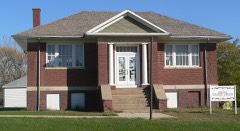 | Dallas Carnegie Library | building | 1976 | 76001734 |
| Fort Randall | district | 1976 | 76001735 | |
| Gregory Buttes Stone Steps | site | 2004 | 04000763 | |
| Gregory County Courthouse | building | 2021 | 100006095 | |
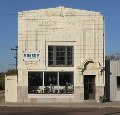 | Gregory County State Bank | building | 1998 | 98001399 |
 | Gregory National Bank | building | 2013 | 13000573 |
 | Herrick Elevator | district | 2003 | 03000498 |
 | Herrick Public School | building | 2000 | 00001000 |
| Pocahontas Schoolhouse | building | 1973 | 73001743 | |
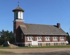 | St. Augustine Church | building | 2009 | 09000944 |
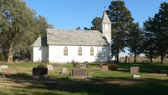 | St. John's Catholic Church | building | 2009 | 09000945 |
 | Tackett Underwood Building | building | 1999 | 99000678 |
Every wildfire the federal occurrence database records inside this county: 111 of them, burning about 2,441 acres. 9 started naturally and 1 was recorded as arson. Each settlement page carries the fires within five miles of it.
| Reported cause | Fires |
|---|---|
| Missing data/not specified/undetermined | 59 |
| Debris and open burning | 19 |
| Equipment and vehicle use | 16 |
| Natural | 9 |
| Misuse of fire by a minor | 4 |
| Smoking | 2 |
| Fireworks | 1 |
| Arson/incendiarism | 1 |
The five largest, by the area the report gives. None of them was recorded as arson.
| Date | Cause | Size | Reported by | Name on the report |
|---|---|---|---|---|
| 19 February 2014 | Missing data/not specified/undetermined | 900 acres | South Dakota Wildland Fire Suppression | LANDING CREEK |
| 25 September 2000 | Equipment and vehicle use | 215 acres | Highmore Volunteer Fire Department | OLSON |
| 5 August 2012 | Missing data/not specified/undetermined | 142 acres | South Dakota Wildland Fire Suppression | LECHTENBERG FIRE |
| 16 August 2012 | Equipment and vehicle use | 112 acres | Karl Mundt National Wildlife Refuge | KARL MUNDT |
| 24 March 2011 | Missing data/not specified/undetermined | 100 acres | South Dakota Wildland Fire Suppression | SOUTH FORK FIRE |
| 2 May 2009 | Debris and open burning | 90 acres | South Dakota Wildland Fire Suppression | not named |
| 6 October 2011 | Missing data/not specified/undetermined | 90 acres | South Dakota Wildland Fire Suppression | HORN FIRE |
| 1 July 2002 | Equipment and vehicle use | 70 acres | Ravinia Volunteer Fire Department | RIVER HILLS SOUTH OF DAM |
Every settlement page carries the fires within five miles of it - see the settlement index below.
The NOAA Storm Events Database holds 400 reports for this county, causing no deaths, 10 injuries and about $16,683,250 in recorded property damage. Each settlement page carries the reports that name it.
| Kind of event | Reports |
|---|---|
| Hail | 246 |
| Thunderstorm Wind | 111 |
| Tornado | 27 |
| Flood | 7 |
| Flash Flood | 6 |
| Lightning | 1 |
| Funnel Cloud | 1 |
| Heavy Rain | 1 |
The most serious of them, by death, then injury, then recorded damage. The accounts are quoted exactly as the forecast office filed them.
| When | Event | Place named | Harm | What the report says |
|---|---|---|---|---|
| May 1959 | Tornado (F1) | not stated | 3 hurt, $25,000 | no account filed |
| August 2019 | Tornado (EF1) | Burke | 2 hurt, $7,000,000 | A tornado developed and touched down in the heart of town near Washington and 7th streets, causing damage to several trees at the touchdown point. Shortly after, the tornado severely damaged several structures while tracking south, including leveling several buildings at the lumber yard, destroying the civic center, and causing significant damage to the school. The start of the school year was delayed by two weeks due to extent of the damage. Two people were (directly) injured by debris when a garage collapsed on them while moving vehicles to safety. Numerous power transmission poles and lines were removed by the tornado. Around 2 miles south southeast of Burke, the tornado struck a residence causing severe damage to the roof. Shortly thereafter, the tornado lifted before reaching the intersection of 295th Street and 345th Avenue after traveling a bit less than 4 miles. The path width reached a maximum of 75 yards within the city of Burke. Up to 3000 trees were damaged by the tornado in and near Burke. Property damage costs are rough estimates. |
| May 1962 | Tornado (F1) | not stated | 2 hurt, $2,500,000 | no account filed |
| August 1954 | Tornado (F2) | not stated | 2 hurt, $250 | no account filed |
| August 2002 | Hail | Herrick | 1 hurt, $100,000 | Large hail, driven by severe winds, broke windows in vehicles and buildings, and cause other damage to vehicles. A man was slightly injured when he was hit by hail while sitting in his pickup, after the hail had broken the window. Some area crops, already described to be in poor shape, were totally destroyed by the wind driven hail. The amount of crop damage was not known. The hail accumulated up to six inches, with drifts to two feet. |
| August 2009 | Hail | Dixon | $2,000,000 | Large hail, up to two inches in diameter, fell in a swath a few miles wide from northwestern to south central Gregory County. The hail broke numerous windows, severely damaged siding and roofs of homes and other buildings, and severely damaged vehicles, while covering the ground in several places. Property damage was especially severe in the town of Gregory. Crop damage was also severe along the swath, with corn crops in some areas destroyed to the point of only small stubble left. |
| March 2019 | Flood | Paxton | $1,380,000 | Flooding resulted in extensive damage to public infrastructure including numerous county and township roads, culverts, and some bridges. |
| August 2002 | Tornado (F2) | Herrick | $1,000,000 | A tornado destroyed a church, a county highway shop, several garages, several small sheds, a mobile home, a camper, and a ten thousand bushel silo. The church was ripped from its foundation, with debris and contents blown over a wide area. Tree damage includes uprooted trees, and power lines were blown down. A resulting power outage lasted for several hours. Windows in many homes and some businesses were broken. The Herrick Honey House was severely damaged, and a honey truck was tipped over. Holes were punched in the walls of some houses by flying debris. |
| August 2019 | Flash Flood | Dixon | $630,000 | Numerous county roads were damaged with culverts or roads washed out. |
| July 1999 | Hail | Gregory | $500,000 | no account filed |
| June 2024 | Flood | Paxton | $352,000 | Rainfall amounts across Gregory County from June 20-22 generally ranged from 2 to 5 inches. Some overland flooding ensued with 84 damage reports to roads, most due to plugged culverts. Preliminary damage assessments estimate loss to public infrastructure across the county to be nearly 352 thousand dollars. |
| June 1966 | Tornado (F2) | not stated | $250,000 | no account filed |
| September 2019 | Flood | Paxton | $205,000 | Flooding resulted in crop losses and damage to public infrastructure including numerous county and township roads, culverts, and some bridges. Crop loss estimates provided by the United States Department of Agriculture. |
| August 2019 | Thunderstorm Wind | Burke | $100,000 | A metal building was destroyed by strong thunderstorm winds. |
| June 2009 | Hail | Carlock | $100,000 | Large hail covered the ground in a swath several miles long. The hail broke windows in numerous vehicles and several buildings, covered the ground, and severely damaged crops. A swath of crops several miles long, especially oats, alfalfa, and corn, was estimated to be near 100 percent loss. The amount of crops damage could not be determined, as there were several areas where crops, especially corn, was expected to partially recover. |
| June 2008 | Hail | Fairfax | $100,000 | Large hail damaged crops in the area, but the amount of crop damage was not known. The hail also damaged roofs, siding, and windows, especially on farm buildings and vehicles. The hail also dented vehicles. |
| June 2008 | Hail | Gregory Arpt | $100,000 | Large hail covered the ground to a depth of 2 inches. The hail broke window, damaged roofs and siding, and dented vehicles. The hail also caused severe crop damage in the area. The amount of crop damage was not known. |
| June 2008 | Hail | Bonesteel | $50,000 | Large hail damaged the siding and broke windows on homes, dented vehicles, and caused crop damage in the area. The amount of crop damage was not known. |
| September 1997 | Thunderstorm Wind | St Charles | $50,000 | Thunderstorm winds blew over a large electrical transmission tower, leaving 750 people without power for four hours. The winds also blew over a semi-trailer and caused tree damage. |
| June 1994 | Thunderstorm Wind | Burke | $50,000 | A radio antenna tower and many trees were blown down. |
| August 2019 | Thunderstorm Wind | Burke Muni Arpt | $40,000 | Wooden power poles broken off by thunderstorm winds. A large area of 80 to 100 mile per hour winds accompanied the tornadic development. |
| May 2007 | Thunderstorm Wind | Gregory | $30,000 | Thunderstorm winds heavily damaged a Cenex fertilizer building. Equipment inside the building was damaged as it was blown across an adjoining field. The winds also damaged several houses, and blew trailers into a street. |
| August 2019 | Thunderstorm Wind | Burke | $25,000 | Numerous large branches were brought down on power transmission lines in the city of Burke. |
| June 2020 | Hail | Lucas | $10,000 | Hail damaged several cars. Property damage costs are rough estimates. |
| June 2003 | Thunderstorm Wind | Lucas | $10,000 | Thunderstorm winds blew the roof off a large hay shed and destroyed a cattle shed. Several windows were broken at a lodge. |
| June 2002 | Thunderstorm Wind | Herrick | $10,000 | Thunderstorm winds blew down power lines and poles, and caused tree damage. |
| July 1999 | Thunderstorm Wind | Dallas | $10,000 | no account filed |
| July 1997 | Thunderstorm Wind | Lucas | $10,000 | no account filed |
| July 2017 | Thunderstorm Wind | Fairfax | $6,000 | Grain bin damaged and outbuildings. |
| August 2019 | Flash Flood | Gregory | $5,000 | Several roads were under a half foot to foot of flowing water in town. Property damage costs are rough estimates. |
| August 2019 | Hail | Dixon | $5,000 | Hail destroyed a car windshield and headlights. |
| July 2008 | Thunderstorm Wind | Dixon | $5,000 | Thunderstorm winds destroyed a farm building and blew the debris across a road. The winds also blew down power lines. |
| June 2008 | Hail | Burke | $5,000 | Large hail severely damaged 500 acres of oat, corn, and sunflower crops on one farm. The amount of crop damage was not known. The hail also broke windows on one side of a house on the farm, and damaged the siding and roof of the house. |
| August 2003 | Thunderstorm Wind | Bonesteel | $5,000 | Thunderstorm winds ripped siding off a house, flipped over a large dumpster, and caused tree damage. |
| May 2000 | Hail | Gregory | $5,000 | no account filed |
| August 1997 | Thunderstorm Wind | St Charles | $5,000 | no account filed |
| September 1985 | Tornado (F1) | not stated | $2,500 | no account filed |
| May 1965 | Tornado (F3) | not stated | $2,500 | no account filed |
| May 2025 | Thunderstorm Wind | Bonesteel | - | Thunderstorm wind gust was measured by a personal weather station. |
| July 2025 | Hail | Gregory Arpt | - | In addition to hail up to half dollar size, heavy rain and 40-50 mph wind gusts stripped some leaves from trees. |
| July 2025 | Thunderstorm Wind | Dixon | - | Thunderstorm wind gusts were measured by a Road Weather Information System sensor 2 miles east of Dixon. |
| July 2025 | Thunderstorm Wind | Herrick | - | Thunderstorm wind gusts were measured by a personal weather station. |
| July 2025 | Thunderstorm Wind | Bonesteel | - | Several large tree limbs down in town. |
| July 2025 | Thunderstorm Wind | Ft Randall | - | Thunderstorm wind gusts were measured by a Road Weather Information System sensor near Pickstown. |
| July 2025 | Hail | Burke | - | Hail occurred for 15 minutes, as size varied from quarters to golf balls. Most hail was quarter to half-dollar size. |
| August 2025 | Thunderstorm Wind | Dixon | - | Thunderstorm wind gusts were measured by South Dakota Mesonet station GRMS2 Gregory 16N. |
| August 2025 | Thunderstorm Wind | Herrick | - | Thunderstorm wind gusts as high as 62 mph were measured by a personal weather station. |
| August 2025 | Thunderstorm Wind | Paxton | - | Thunderstorm winds, which gusted as high as 60 mph, were measured by South Dakota Mesonet station GGMS2 Gregory 7SSW. |
| August 2025 | Thunderstorm Wind | Dixon | - | Thunderstorm wind gusts were measured by a Road Weather Information System sensor 2 miles east of Dixon. |
| August 2025 | Thunderstorm Wind | Dixon | - | Thunderstorm wind gusts were measured by South Dakota Mesonet station GRMS2 Gregory 16N. |
| July 2025 | Tornado (EF2) | Bonesteel | - | This was the third tornado documented by a storm chaser across Gregory County. This tornado touched down west of Whetstone Bay on the Missouri River, north of Whetstone Township Highway and to the west of County Road 57. After a very short distance, the tornado broke multiple power poles along County Road 57 as it traveled south-southeast. The tornado then traveled for 5 miles across unpopulated complex terrain with no road access, although its damage path was visible on Copernicus Sentinel data 2025. Coming out of the hills, the tornado hit a single family dwelling, with the collapse of all exterior walls among other major damage. Two nearby outbuildings were also destroyed. The tornado continued to the south-southeast for approximately 1.5 miles before it flipped a camper and destroyed an abandoned trailer on the north side of Bonesteel. The tornado lifted a few hundred yards north of Eldeen Avenue, missing the city-center of Bonesteel. The tornado was rated EF2 with an estimated maximum wind gust of 135 mph. The average path width was estimated at 125 yards. |
| July 2025 | Tornado (EF1) | Dixon | - | A storm chaser documented the initial touchdown of a tornado a little over a mile to the northwest of Dixon, SD just north of 276th Street in an open field. The tornado traveled to the east-southeast for around 2 miles before it impacted the north side of a farmstead where it damaged the shelter belt and destroyed an older outbuilding. As it continued along the path, it crossed near the intersection of SD 47 and SD 44 where it downed power poles and twisted a couple of SDDOT truck shelters. The tornado then traveled over mainly open fields for another 2 to 3 miles before taking a slight turn more to the southeast. After around 5 more miles on a southeastward path, the tornado lifted in an area of more uneven terrain. The tornado was rated EF1 with an estimated maximum wind gust of 110 mph. The average path width was around 100 yards. |
| July 2025 | Tornado (EF0) | Lucas | - | A storm chaser documented the initial touchdown of a tornado less than one mile northwest of Lucas, SD a bit southeast of the intersection of 283rd Street and 347th Avenue. The tornado then tracked southeast for around one mile, narrowly missing the town of Lucas but uprooting three large pine trees at 284th Street and 348th Avenue. After crossing the intersection, the tornado shredded the tree line just to the east of a hunting lodge. The tornado traveled across an open section before turning more southerly and again impacting a tree line at the mid-section line. The tornado crossed 349th Avenue and left a track in some mature corn before lifting just east of 349th Avenue. The tornado was rated EF0 with an estimated maximum wind gust of 85 mph. The average path width was 25 yards. |
| June 2025 | Thunderstorm Wind | Dixon | - | Winds measured by South Dakota Mesonet station Gregory 16N. |
| June 2025 | Hail | Herrick | - | Hail fell for several minutes, but was only briefly nickel to quarter size. |
| June 2025 | Hail | Herrick | - | Dime to quarter-sized hail fell near Herrick. |
| July 2024 | Thunderstorm Wind | Dixon | - | An extended duration of strong to severe winds gusted at times to 61 mph at the SDSU mesonet station 16 miles north of Gregory. |
| July 2024 | Thunderstorm Wind | Dixon | - | Thunderstorm wind gusts reached severe levels at the South Dakota Road Weather Information System site near Dixon, then attained a peak of 72 mph at 223 am CST. |
| July 2024 | Thunderstorm Wind | Dallas | - | A thunderstorm wind gust of 58 mph was measured by the South Dakota Road Weather Information System site at Dallas. |
| July 2024 | Hail | Lucas | - | Hail ranged from golf ball to baseball size. Multiple windshields were broken with large dents in vehicles and corn was stripped of most of its leaves. |
The Survey's mineral resources record lists 11 workings inside this county. 7 still produce and 4 are closed or unrecorded. Each settlement page carries the workings within five miles of it.
| Commodity | Workings |
|---|---|
| Sand and Gravel, Construction | 11 |
The least common of them first, because a county's hundredth gravel pit says nothing its first ten did not.
| Where | Site | Commodity | Status | Recorded |
|---|---|---|---|---|
| Burke Sand & Gravel Pit | Sand and Gravel, Construction | Producer | ||
| Buryanek Gul Pit | Sand and Gravel, Construction | Producer | ||
| Cahill Pit | Sand and Gravel, Construction | Past Producer | ||
| Dave Liebel Pit | Sand and Gravel, Construction | Past Producer | ||
| Fedde Pit | Sand and Gravel, Construction | Producer | ||
| Grimm Pit | Sand and Gravel, Construction | Past Producer | ||
| Hollis Haisch Gravel Pit | Sand and Gravel, Construction | Producer | ||
| Opperman Sand & Gravel Pit | Sand and Gravel, Construction | Past Producer | ||
| Paul Liebel Pit | Sand and Gravel, Construction | Producer | ||
| Rosebud Sioux Gravel Pit 1121 | Sand and Gravel, Construction | Producer | ||
| Rosebud Sioux Pit 219 1/2 | Sand and Gravel, Construction | Producer |
Named settlements recorded in the Geographic Names Information System, each with the topographic sheets covering it. Villages, hamlets and abandoned places alike. Each is shown with the nearest named watercourse or landform and the survey quadrangle it falls on.
Southeast Gregory unorganized territory · 68719 · Fort Randall Dam quadrangle
10 sheets, 1955 to 1990
East Gregory unorganized territory · 57571 · Saint Charles quadrangle
8 sheets, 1955 to 1990