 Block
From the record
7 National Register listings published here.
Sources: the National Register database, National Park Service
27 topographic sheets cover 14 settlements here, and 7 properties are on the National Register of Historic Places.
7 National Register listings published here.
Sources: the National Register database, National Park Service
Every property in this county listed on the National Register of Historic Places, with the year it was listed and the federal nomination document.
| Photograph | Property | Type | Listed | Reference |
|---|---|---|---|---|
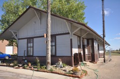 | Chicago, Milwaukee, and St. Paul Railroad Depot | building | 1986 | 86001478 |
| Tom Jones Ranch | district | 1990 | 90001653 | |
 | Minuteman Missile National Historic Site | site | 1999 | 01000275 |
 | Mt. Moriah Masonic Lodge #155 | building | 2004 | 04000765 |
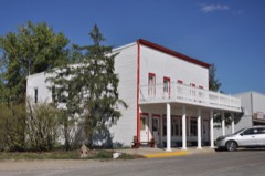 | Pearl Hotel | building | 2007 | 07000587 |
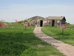 | Prairie Homestead | district | 1974 | 74001891 |
| Triangle Ranch | building | 1994 | 94000563 |
Every wildfire the federal occurrence database records inside this county: 478 of them, burning about 46,381 acres. 118 started naturally and 19 were recorded as arson. Each settlement page carries the fires within five miles of it.
| Reported cause | Fires |
|---|---|
| Natural | 118 |
| Missing data/not specified/undetermined | 104 |
| Equipment and vehicle use | 66 |
| Debris and open burning | 56 |
| Misuse of fire by a minor | 51 |
| Fireworks | 20 |
| Arson/incendiarism | 19 |
| Other causes | 17 |
| Smoking | 12 |
| Power generation/transmission/distribution | 11 |
| Recreation and ceremony | 3 |
| Railroad operations and maintenance | 1 |
The five largest, by the area the report gives. None of them was recorded as arson.
| Date | Cause | Size | Reported by | Name on the report |
|---|---|---|---|---|
| 1 November 1999 | Power generation/transmission/distribution | 9,000 acres | Trail City Volunteer Fire Department | BULLHEAD |
| 10 August 2006 | Natural | 5,700 acres | Pine Ridge Agency | GOOD FIRE |
| 16 July 2017 | Misuse of fire by a minor | 5,305 acres | Pine Ridge Agency | WANBLEE TIMBER |
| 15 September 2000 | Natural | 5,000 acres | Interior Volunteer Fire Department | REDWATER/LENZGRAF |
| 10 August 2006 | Natural | 2,000 acres | Pine Ridge Agency | THOMPSON |
| 25 December 1999 | Debris and open burning | 1,100 acres | Pine Ridge Agency | KYLE |
| 5 March 2000 | Debris and open burning | 1,100 acres | Pine Ridge Agency | CLUSTER |
| 19 July 2012 | Missing data/not specified/undetermined | 1,084 acres | Nebraska National Forest | CACTUS |
Every settlement page carries the fires within five miles of it - see the settlement index below.
The NOAA Storm Events Database holds 701 reports for this county, causing no deaths, 5 injuries and about $3,536,560 in recorded property damage. Each settlement page carries the reports that name it.
| Kind of event | Reports |
|---|---|
| Thunderstorm Wind | 354 |
| Hail | 292 |
| Tornado | 20 |
| Flood | 20 |
| Flash Flood | 9 |
| Heavy Rain | 3 |
| Wildfire | 2 |
| Funnel Cloud | 1 |
The most serious of them, by death, then injury, then recorded damage. The accounts are quoted exactly as the forecast office filed them.
| When | Event | Place named | Harm | What the report says |
|---|---|---|---|---|
| June 2001 | Thunderstorm Wind | Wanblee | 2 hurt, $382,500 | no account filed |
| June 2025 | Tornado (EF2) | Kadoka | 2 hurt | The tornado touched down 100 yards west of the Highway 73 White|River Bridge. As the tornado moved to the southeast in the river|valley, the first residence that suffered significant damage was|just east of Highway 73, on County Road 29. This home suffered|partial exterior wall collapse, with most of the roof structure|gone. Additionally, mature Cottonwood trees were snapped at|this location. As the tornado continued to move east-southeast|down the river valley, it encountered house number 2, also on|County Road 29. Several outbuildings were destroyed at this|location, along with mature Cottonwood trees that were|snapped and partially debarked. The 3rd residence, located along|County Road 80, or Red Stone Rd, was a new manufactured home that|suffered complete destruction. Two individuals were in the home at|the time and suffered minor injuries. The home was strapped down,|with the straps anchored in concrete. It is estimated the house|rolled 3 times, with the house separating from the frame. The|frame became partially wrapped around the trunk of a fallen|Cottonwood tree. There were numerous mature Cottonwood trees|snapped and partially debarked, as well as uprooted, on this|property. The debris from the house was blown to the north through|northeast toward the White River. The tornado continued moving|east-southeast in the river valley, snapping and debarking mature|Cottonwood trees before it lifted. |
| June 2001 | Thunderstorm Wind | Cedar Pass | 1 hurt | no account filed |
| August 2011 | Hail | Belvidere | $500,000 | Large hail caused significant damage to vehicles on Interstate 90 between mile markers 170 and 174. Wind gusts reached 50 mph. |
| June 2008 | Flood | Belvidere | $500,000 | The White River overflowed its banks from south of Interior to south of Belvidere and covered Highway 44. Flooding was reported along Cottonwood Creek, the South Fork of the Bad River, and their tributaries. Flooding was also reported around Cottonwood, Kadoka, and Interior. |
| May 2012 | Thunderstorm Wind | Kadoka | $400,000 | Wind gusts estimated at 90 mph blew roofs off two buildings, including the hardware store, and downed trees and power poles. |
| March 2019 | Flood | Wanblee | $250,000 | Ice jams, combined with runoff from melted snow, caused minor to moderate flooding along the White River and other small creeks in Jackson County. Minor flooding occurred near Interior from March 22 through March 25. Further downstream, south of Kadoka, moderate flooding occurred with widespread flooding of agricultural land and outbuildings. On March 25, the high flows eroded away the river bank where the stream gage south of Kadoka was located. Based on high water marks, the USGS determined the river crested at 15.34 feet at the old location and 16.72 feet at the new upstream location. This would be the fourth highest river level at this location and the highest river level since 1982. Additional flooding occurred around the Long Valley and Wanblee areas, including along Fish Creek Road, where a county bridge was destroyed by flood waters. |
| May 2019 | Flood | Cottonwood | $200,000 | Significant flooding occurred along the White River south of Kadoka. A record gauge height of 17.57 feet was set (flood stage is 13 feet), with a peak flow of 17,800 cfs, which is the highest flow recorded since measurements began at this location in 1942. Widespread flooding of agricultural land occurred and several outbuildings were inundated. A county road and bridge about 10 miles downstream of the gauge were washed out and SD Highway 44 south of Interior was covered with water in three locations. |
| July 2013 | Hail | Kadoka | $200,000 | Hail damaged vehicles along Interstate 90 near Kadoka. |
| June 2010 | Hail | Belvidere | $150,000 | Hail damaged automobiles and buildings in Belvidere. |
| July 2009 | Thunderstorm Wind | Kadoka | $150,000 | The combination of wind and hail damaged automobiles and buildings in Kadoka. |
| May 2007 | Heavy Rain | Interior | $67,000 | Almost four inches of rain (3.95) fell in six hours. Water briefly covered highway 44 south of the White River when a culvert plugged up with debris. |
| July 2010 | Thunderstorm Wind | Long Valley | $50,000 | Some automobiles in Long Valley were damaged by the winds and hail. |
| May 2005 | Hail | Longvalley | $50,000 | no account filed |
| May 2010 | Thunderstorm Wind | Belvidere | $30,000 | Thunderstorm wind gusts tore part of a roof off a house, damaged the interior of the house, and scattered the debris across the yard. The garage doors were blown inward and a fuel tank was thrown into a car. |
| June 2013 | Hail | Potato Creek | $30,000 | no account filed |
| August 2011 | Thunderstorm Wind | Kadoka | $25,000 | Minor damage occurred in Kadoka from winds gusts estimated around 80 mph. |
| June 2010 | Hail | Cactus Flats | $25,000 | Golfball sized hail caused minor damage to automobiles. |
| June 1980 | Tornado (F0) | not stated | $25,000 | no account filed |
| June 1980 | Tornado (F0) | not stated | $25,000 | no account filed |
| June 1980 | Tornado (F0) | not stated | $25,000 | no account filed |
| June 1980 | Tornado (F0) | not stated | $25,000 | no account filed |
| June 1980 | Tornado (F0) | not stated | $25,000 | no account filed |
| June 1980 | Tornado (F0) | not stated | $25,000 | no account filed |
| July 1979 | Tornado (F1) | not stated | $25,000 | no account filed |
| May 1964 | Tornado (F2) | not stated | $25,000 | no account filed |
| June 2024 | Thunderstorm Wind | Potato Creek | $20,000 | Wind driven hail up to quarter size broke house and car windows and uprooted trees. |
| June 2015 | Thunderstorm Wind | Belvidere | $20,000 | Four semi tractor-trailers were blown over along Interstate 90 between mile markers 170 and 174. Four nearby grain bins and a pole barn were blown down; one flew across the Interstate. Several telephone poles were snapped. Time was estimated by the sheriff. |
| October 2011 | Thunderstorm Wind | Cottonwood | $20,000 | The roof was blown off a seed house and buildings and a tractor were damaged by strong wind gusts. |
| June 2011 | Flash Flood | Belvidere | $20,000 | Heavy rain flooded a 600 foot section of SD Highway 63 north of Interstate 90, washed out several rural roads, and caused a stock dam to fail. Significant flooding occurred along Ash and Brave Bull Creeks in northeastern Jackson County. |
| June 2010 | Hail | Belvidere | $20,000 | Hail accumulated into drifts. |
| July 2003 | Thunderstorm Wind | Cedar Pass | $20,000 | Wind damaged buildings and campground structures at Badlands National Park's Cedar Pass and large trees were uprooted. |
| July 1995 | Thunderstorm Wind | Kadoka | $20,000 | Strong winds of 60-75 mph did major damage in parts of Kadoka. Roofs were torn off buildings, big trees were uprooted, buildings and vehicles were damaged. An Old Home bread truck was laid over on Interstate-90 near Kadoka. People said the roar of the wind sounded like a tornado. Damage was estimated in the tens of thousands of dollars. |
| August 2011 | Hail | Belvidere | $20,000 | no account filed |
| June 2010 | Hail | Kadoka | $20,000 | no account filed |
| July 2011 | Flash Flood | Kadoka | $10,000 | Streets, yards, parks, and a few homes in Kadoka flooded after more than three inches of rain fell. |
| April 2010 | Thunderstorm Wind | Belvidere | $10,000 | Thunderstorm winds blew roofs off three pole barns and scattered the tin across a county road. |
| July 2010 | Thunderstorm Wind | Wanblee | $10,000 | The combination of hail and wind produced minor damage to a home and automobile. |
| July 2007 | Thunderstorm Wind | Interior | $10,000 | Thunderstorm wind gusts snapped 5 power poles and a flag pole and blew a horse trailer down a hill. |
| May 2006 | Thunderstorm Wind | Interior | $10,000 | Airplane hanger damaged. |
| June 2013 | Hail | Cactus Flats | $10,000 | no account filed |
| June 2005 | Hail | Belvidere | $10,000 | no account filed |
| May 2005 | Hail | Longvalley | $10,000 | no account filed |
| May 2012 | Hail | Kadoka | $5,000 | Wind-driven hail damaged shingles and broke house windows. |
| August 2012 | Thunderstorm Wind | Belvidere | $5,000 | A tractor trailer was blown over by the strong winds. |
| March 2011 | Flood | Interior | $5,000 | Flooding occurred along the White River. At least two homes were surrounded by water and several oubuildings were flooded. The river gage on the SD Highway 44 bridge southeast of Interior crested at 15.5 feet, or 1.5 feet above flood stage. The river gage on the SD Highway 73 bridge south of Kadoka crested at 13.7 feet, or 0.7 feet above flood stage. |
| July 2011 | Flash Flood | Interior | $5,000 | Water flowed over stock dams and small streams flooded south of Potato Creek. |
| September 2011 | Hail | Long Valley | $5,000 | Golf ball sized hail broke windows. |
| June 2010 | Thunderstorm Wind | Cedar Pass | $5,000 | Strong winds and hail caused minor damage to automobiles. |
| December 1995 | Thunderstorm Wind | Cottonwood | $5,000 | The thunderstorm that began in Pennington County moved east into northern Jackson County causing light structural damage in the Cottonwood area and blew over a tractor-semitrailer on Interstate 90 between Wall and Kodoka. |
| July 2015 | Hail | Long Valley | $5,000 | no account filed |
| June 2012 | Hail | Interior | $5,000 | no account filed |
| July 2009 | Hail | Cottonwood | $5,000 | no account filed |
| June 2005 | Hail | Kadoka | $5,000 | no account filed |
| July 2013 | Hail | Belvidere | $3,000 | Large hail damaged the north side of a building. |
| June 2010 | Hail | Wanblee | $3,000 | Quarter sized hail and gusty winds broke windows of houses and produced hail drifts. |
| July 2001 | Thunderstorm Wind | Cottonwood | $2,000 | Windows were broken out of a home. |
| June 1996 | Hail | Interior | $1,500 | no account filed |
| June 2016 | Thunderstorm Wind | Belvidere | $1,000 | Signs were blown down by the wind. |
| May 2012 | Thunderstorm Wind | Kadoka | $1,000 | Trees were uprooted by the wind. |
The Survey's mineral resources record lists 3 workings inside this county. None of them still produces: all are closed or unrecorded. Each settlement page carries the workings within five miles of it.
| Commodity | Workings |
|---|---|
| Zeolites | 3 |
The least common of them first, because a county's hundredth gravel pit says nothing its first ten did not.
| Where | Site | Commodity | Status | Recorded |
|---|---|---|---|---|
| Unidentified Occurrence | Zeolites | Occurrence | Clinoptilolite | |
| Unidentified Occurrence | Zeolites | Occurrence | Clinoptilolite | |
| Unidentified Occurrence | Zeolites | Occurrence | Clinoptilolite |
Named settlements recorded in the Geographic Names Information System, each with the topographic sheets covering it. Villages, hamlets and abandoned places alike. Each is shown with the nearest named watercourse or landform and the survey quadrangle it falls on.
Northwest Jackson unorganized territory · 57567 · Cottonwood SW quadrangle
6 sheets, 1955 to 1980
Northwest Jackson unorganized territory · 57775 · Cottonwood quadrangle
6 sheets, 1955 to 1980
Northeast Jackson unorganized territory · 57543 · Kadoka quadrangle
6 sheets, 1951 to 1980
Southwest Jackson unorganized territory · 57547 · Long Valley quadrangle
5 sheets, 1955 to 1983
Southwest Jackson unorganized territory · 57750 · On Bull Creek · Potato Creek quadrangle
6 sheets, 1950 to 1980
Northeast Jackson unorganized territory · 57543 · Weta quadrangle
6 sheets, 1950 to 1980
Northeast Jackson unorganized territory · 57521 · Stamford quadrangle
5 sheets, 1955 to 1980